ThinkPad T60 with Google Maps in Motion
Gimmick or practical you decide...
Source: Crave
Related Source:bulknews
Labels: Google Map, Motion, T60, ThinkPad
posted by Mapperz @ 8:42 am
0 comments
![]()
![]()
Mapperz - The Map & GIS News finding blog. With so many Mapping sites online. This blog tries to provide you with the best maps and services that are currently available online. @mapperz
Gimmick or practical you decide...
Labels: Google Map, Motion, T60, ThinkPad
posted by Mapperz @ 8:42 am
0 comments
![]()
![]()
Google Earth vs ArcGIS Explorer which is better?


Labels: ArcGIS Explorer, compared, Earth, ESRI, Google
posted by Mapperz @ 5:46 pm
5 comments
![]()
![]()
Update: ESRI's answer to Google Earth is available here (login required)


Labels: ArcGIS, ArcGIS Explorer, Beta, Online
posted by Mapperz @ 8:24 am
0 comments
![]()
![]()
Track the Sun setting or rising in real-time.
As the map runs in real-time, you can watch different parts of the earth move from night to day (and vice versa).
You can choose between close-up views of the sunrise (night-to-day) and sunset (day-to-night) halves of the terminator. Sunrise (the part of the earth moving out of the shadow) is shown in yellow, moving across the landscape. Sunset (the parts of the earth moving into shadow) is shown in blue.
Latitude is how far north or south of the equator (from 0 to 90 degrees) a place is. You can choose which latitude you want the view centred on. Either click the map (you may find navigation easier if you zoom out first) to centre on that latitude, or enter a value from +90 degrees (the North Pole) to -90 degrees (the South Pole).
Note that areas within the Arctic and Antarctic circles may be in permanent daylight or night during winter or summer, so it's impossible to show sunrise and sunset in such cases.
posted by Mapperz @ 11:00 pm
0 comments
![]()
![]()

Labels: England, Interactive Map., Oxford, Travel
posted by Mapperz @ 9:10 pm
1 comments
![]()
![]()

Labels: Congestion, Google, Mapping, Mashups, Traffic, Travel
posted by Mapperz @ 7:52 pm
0 comments
![]()
![]()
A nice update from gTraffic incorporating time to a Google Maps Mashup.


Labels: Google Map, gTraffic, Time, update
posted by Mapperz @ 7:59 pm
0 comments
![]()
![]()
Some google mappers have noticed that you can create kml files from google maps


Labels: Directions, Google Map, KML, XML Google Earth
posted by Mapperz @ 3:29 pm
6 comments
![]()
![]()
Stefan Blanke has been working on a very sophisticated Google Map Editor


posted by Mapperz @ 5:36 pm
0 comments
![]()
![]()
Using the Time Element it is possible to Animate features within Google Earth 4 (Beta 6).
 in 3D - Google Earth")
posted by Mapperz @ 8:30 am
0 comments
![]()
![]()
Nice to see animated icons coming into Google Maps.

posted by Mapperz @ 5:08 pm
1 comments
![]()
![]()
Google Maps 'Ads' Sponsored Links

Labels: Adverts, Google, Maps, Sponsored Links
posted by Mapperz @ 1:00 pm
0 comments
![]()
![]()
Since the hot topic. UK Addresses -Geocoded via Google Maps API


posted by Mapperz @ 9:13 pm
0 comments
![]()
![]()
Based in the Geography department at the University of Sheffield they been busy creating new cartograms.

Labels: Cartogram, Mapping, University, World
posted by Mapperz @ 1:05 pm
0 comments
![]()
![]()
Google are seeming to be testing Map Integration into their Web Search results

Labels: Google, Maps, Web.Search
posted by Mapperz @ 8:32 am
0 comments
![]()
![]()
Average weather charts for 4305 global locations. Most show precipitation, many show high and low temperatures, some also have humidity.

Labels: Charts, Climate, Global, Google, Map, Mapping, Rainfall, Weather
posted by Mapperz @ 8:40 am
1 comments
![]()
![]()

Labels: Cartography, Free, London, Maps, UK
posted by Mapperz @ 5:31 pm
0 comments
![]()
![]()
Google Maps Mania posts are filled with the lastest google maps mashups.

posted by Mapperz @ 12:04 pm
1 comments
![]()
![]()
posted by Mapperz @ 10:02 pm
0 comments
![]()
![]()
A simple way to create a Google Map with Search. Ideal for all non-coders...

posted by Mapperz @ 8:43 pm
0 comments
![]()
![]()
Google have added 'Click to Call' on the North American maps (http://maps.google.com/) but not available in the UK (http://maps.google.co.uk) as yet.

posted by Mapperz @ 10:21 am
0 comments
![]()
![]()
The AA Travel Planner has been updated. Points of Interest (POI) have been now included into the Travel Planner and the Street by Street Map Finder


Labels: AA, Maps, Planner, Street by Street, Travel
posted by Mapperz @ 12:49 pm
0 comments
![]()
![]()
A new mapping website that helps the non-coder create a web map with points of interest (POI).

Along with your own custom icons placed in step 1, Aardvark Map gives you the option to automatically add other content onto your map from our partner sites. If you don't want any of this extra content, skip to step 3.
To add the content overlays, simply select select the appropriate checkboxes below.
Step 3
Saves the map and provides you with the unique map code:
Once any custom points and content overlays have been added, you can generate the map code.

posted by Mapperz @ 8:11 am
0 comments
![]()
![]()
Good to see that Google are expanding data coverage across the world. But be very wary on the accuracy of the data.


Labels: Cartographic, Data, Generalization, Google, Issues, Maps
posted by Mapperz @ 8:41 am
0 comments
![]()
![]()
Interesting to see the outcome of this test.


posted by Mapperz @ 2:44 pm
1 comments
![]()
![]()
Mapperz reported back in August 2006 about UK Geocoding using Local Live and the permalink feature. This contains the Longitude and Latitude of the Centre of the Map.


Labels: 3D, Geocoding, Live Local, Postcode, UK, Virtual Earth
posted by Mapperz @ 9:34 pm
0 comments
![]()
![]()
22 November


posted by Mapperz @ 4:52 pm
5 comments
![]()
![]()

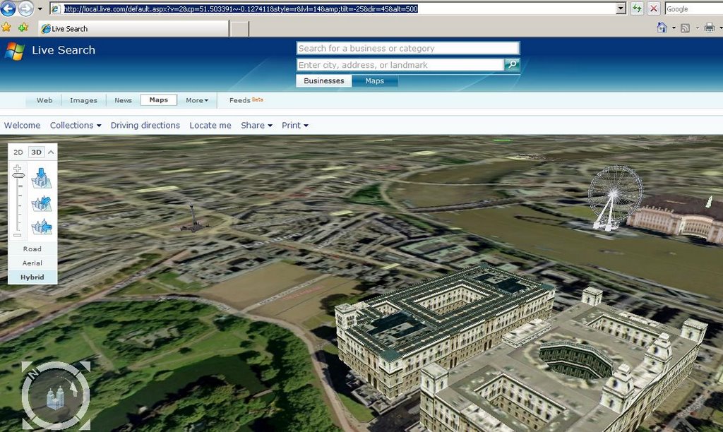
Labels: 3D, Features, Live Local, London
posted by Mapperz @ 12:03 pm
0 comments
![]()
![]()
SkylineGlobe


posted by Mapperz @ 8:51 am
0 comments
![]()
![]()
Official News Blog


posted by Mapperz @ 12:19 am
0 comments
![]()
![]()
Map 24 - 3D on your Mobile (need to sign up for free download)

posted by Mapperz @ 12:37 pm
0 comments
![]()
![]()


© 2014 Mapperz | Contact: mapperz at gmail dot com ( @mapperz|Mapperz 2017
This site supports social networking
![]()
![]()

