->

25 August 2010

ArcGIS Explorer (Build 1500) Released

ArcGIS Explorer (Build 1500) Released

ArcGIS Explorer Build 1500 Released

View OpenStreetMap in 3D (2d is default) via basemaps
ArcGIS Explorer Build Open Street Map in 3D

ArcGIS Explorer Build import your data
Import your .shp, .kml, .gpx, .txt, .csv or even File Geodatabases!

"KML improved; KML handling has been improved in both 2D and 3D mode, and regionated KML is now supported in 2D mode. KML interoperability has also been enhanced; notes can be shared (exported) as KML and KML can be shared (exported) as layer packages or converted to notes. The KML file association can be set to ArcGIS Explorer.

Symbols (more); ArcGIS Explorer symbols have been updated to improve appearance in 2D and 3D modes. Symbol management tools have been enhanced with improved support for custom (user) symbols."

Buffering a point by 100km is possible via Analysis

ArcGIS Explorer Presentation Slide
Create driving directions, add slide (like screen grabs) to presentation - playback is full screen and glides to various screen grabs.

ArcGIS Explorer features new capabilities that enhance interoperability with the ArcGIS system and KML. These features include:

ArcGIS Online integration
Support for ArcGIS Explorer Online maps, including presentations and notes
Share (export) to layer package or KML
Create notes from features
Create notes from KML
Add data directly from Excel spreadsheets

Download here [98.4mb]:
Useful Links

Source:

Labels: , , , ,

14 August 2009

ArcExplorer (build 900) - GIS for Everyone finally...

ArcExplorer (build 900) - GIS for Everyone finally... who has a pc'

There has been quite a wait for this version of ArcExplorer from ESRI. Though finally a product that can be used by all users.
Think along lines of Microsoft Office now has a geo-spatial browser.

ESRI ArcExplorer (build 900)
GIS for Everyone finally...

What is new and why it is finally a useful product?ArcExplorer Import Content
  • New User Interface (very Microsoft Office ribbon like)

  • GIS analysis (such as visibility, direction finding, and proximity search)
  • GeoRSS feeds import
  • New basemap galley for easy access to different base maps
  • 2D/3D modes now caters for the 2D map perspective.
  • Improved KML support and support for layer packages (.lyr support & the .lpk introduced at ArcGIS 9.3.1)
  • GPX data import
  • JPEG 2000, GeoTIFF, MrSID import
  • New presentation mode - useful for presentations.
  • Bing Maps *free to ArcGIS Desktop users - Though visit Bing Maps to view for free.
  • Localisation - dependant on your language
  • Projections - Expansion package required.
Other notes:
ArcGIS Explorer SDK (direct link to .exe file) - 24.5mb
"For developing custom add-ins which extend the capabilities of ArcGIS Explorer. Requires Visual Studio .NET. Note: The SDK must be installed after installing ArcGIS Explorer. For more information read the ArcGIS Explorer SDK Installation Guide"

Optional Expansion Packs:
(direct links to .exe files)

Data Access Expansion Pack (9.9mb)
Expands geodatabase functionality by allowing direct connections to multi-user geodatabases

Fonts Expansion Pack (2.7mb)
Adds more ESRI fonts for use with ArcGIS Explorer. ESRI fonts are used when displaying ArcGIS Layer files and Layer packages.

Projection Engine Expansion Pack(15.2mb)
Adds more projections and geotransformations for use with ArcGIS Explorer

Source:
http://blogs.esri.com/Info/blogs/arcgisexplorerblog/archive/2009/08/13/what-s-new-in-arcgis-explorer.aspx

Official Page:
http://www.esri.com/software/arcgis/explorer/index.html

What's New Guide (with video)
http://www.esri.com/software/arcgis/explorer/whats_new.html

Demos:
http://www.esri.com/software/arcgis/explorer/demos.html

System Requirements
http://www.esri.com/software/arcgis/explorer/system_requirements.html

Download Page:
http://resources.esri.com/arcgisexplorer/900/index.cfm?fa=home
(the main program is 78.4mb)

@Mapperz

Labels: , , , , , , ,

08 October 2007

4D Data in ArcGIS Explorer

4D Data in ArcGIS Explorer - Timeline

"Time Navigator can animate any ESRI Shapefile with point geometry and a timestamp field. The timestamp fields can be date, numeric or textual. Time Navigator is developed as a custom task for ArcGIS Explorer build 410 and can be downloaded from downloaded from ArcScripts (source code is included)." mrrichie


Source: Ogle Earth

Labels: , , , ,

15 August 2007

ArcGIS Explorer - Build 410 Released

ArcGIS Explorer Build 410

Improvements - it's smoother

Result Properties
source: ESRI

* When a result is generated it has a default zoom extent, or view. The default view is from an overhead perspective. You can capture a new view by moving and/or tilting to a new perspective, then using the result property sheet to capture the new view. The view property is persisted with the result.

Navigation with ArcGIS Explorer has been enhanced in the following ways.

Observer Elevator Movement: By default, zooming in and out on the map using the mouse or keyboard will zoom relative to the target location. Holding down the Ctrl-key and using the + and – keys will change the observer elevation. This is similar to traveling up and down in an elevator. This type of movement is useful for viewing vertical features in your map at differing elevations.

Zooming to Cursor Position: Zooming to a location on the map has been enhanced by zooming to the mouse pointer position. You can still zoom to the center of the map by holding down the Ctrl-key while scrolling the mouse wheel. Zooming out always occurs from the center of the map.

Look Replaces Pan at Tilt Angles Larger Than 45 Degrees: In previous versions of ArcGIS Explorer, double clicking on the map when viewing the map tilted beyond 45 degrees would center the clicked location. This often changed the distance from the observer location to the target. Now when the map is tilted beyond 45 degrees, a double-click will use the Look functionality, changing the observer's view without changing the observer position.


* Subsurface Navigation
To get a subsurface view of the earth, tilt your map then hold down the Ctrl key and use the + or - keys to move straight down below the earth or to move straight up.


* Easier Navigator Access
Access to the Navigator is easier; the target area which maximizes the control has been made larger.


* Faster Opening of Server Folders
The performance of opening servers publishing services in multiple sub-folders has been improved.


* Improved Stars
Stars now appear as different sizes and are centered at the observer position to illustrate their correct location, providing a more realistic appearance for the sky and globe.


* Close Shortcut
The keyboard shortcut which closes the application is now Alt-F4 to adhere to standard shortcut conventions.

* Point measurements and point notes now store the view properties captured at the time of their creation. For example, when you add a point note the current view will be captured and stored with the note. You can double-click the note to zoom to the specified view. The view properties can be edited through the result property sheet


* New Find Address task replaces the previous Find Address task found in earlier builds. The new task provides the capabilities to enter address or place in a single input from which it will be parsed and matched.

The Find Route and Get Driving Directions tasks provide a convenient drop down menu allowing you to choose which language to display your directions and routes. The following languages are supported: Danish, Dutch, English, French, German, Italian, Norwegian, Portuguese, Spanish, and Swedish

Free Download
http://services.arcgisonline.com/410/explorer/software/downloadpage.html
(No login required)

Labels: , , , ,

01 May 2007

ArcGIS Explorer (380 Build)

ArcGIS Explorer (380 Build) available for download from ESRI
(if you dare too)

ArcGIS Explorer Build 380
More Google Earth like, but slower.

"You can also change the appearance of ArcGIS Explorer by using skins. At present, each of the three skins that ship with ArcGIS Explorer has a distinct color scheme but does not differ in functionality. The skin color is determined by the color scheme active for your version of the operating system"
Rather have more functionality

Download ~(need an ESRI User Account to access the download)

ArcGIS Explorer Build 380 Crash

Yes it is a serious problem when you try opening a kmz file and it crashes.

ESRI please fix this.
And add support for Personal Geodatabases (your own files). (please)
They have shapefiles...

Labels: , , , ,

17 January 2007

All ESRI Downloads in One Location

Some of latest Free downloads for GIS from ESRI in one location.

Software(Free)

ArcExplorer 9.2 (bulid 350) (43.4 MB)
ArcExplorer 9.2 (AIX) arcexplor92_aix.tar
ArcExplorer 9.2 (HP-UX) arcexplor92_hp.tar
ArcExplorer 9.2 (Linux) arcexplor92_linux.tar
ArcExplorer 9.2 (Solaris) arcexplor92_solaris.tar
ArcExplorer 9.2 (Windows) arcexplorer92_windows.zip

ArcReader 9.2 (175 MB)
ArcReader 9.2 Linux arcreaderlinux92.tar
ArcReader 9.2 Solaris arcreadersolaris92.tar
ArcReader 9.2 Windows arcreader92.zip

More Downloads

Labels: , , , ,

05 January 2007

ArcGIS Explorer 9.2 Gets Fixed

ArcGIS Explorer 9.2 (Build 350) Gets Fixed

Fixed Features

Source: Spatial Adjusted

Note:You will need to Register to Download this Software

ArcGIS Explorer 9.2 (Build 350) is 28.4 MB in file size.

ArcGIS 9.2 Explorer Versions
Version 1.0.348 to 9.2.350

Labels: , , , ,

29 November 2006

Google Earth vs ArcGIS Explorer

Google Earth vs ArcGIS Explorer which is better?
Google Earth Wins

Well this was one of the quickest tests mapperz has ever done.

Google Earth Wins! by a mile.

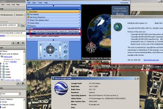
The simplest of tasks - search for '10 Downing Street, London, UK'

Google Earth - 3 seconds to rotate the earth and zoom right into Downing Street and display the aerial photographs at full resolution.

ArcGIS Explorer - Place not Found, Please check your spelling....
(login needed)

ESRI can we please have ArcGIS service pack 1 before the end of the year?
(ESRI software users know about the x.0 curse)

Mapperz recommends Google Earth for the time-being.

Update:
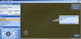
Is it 10 Downing Street, London?
Okay so now you can find 10 Downing Street, London, UK
After entering 3 Input Boxes and Scrolling through a long list to Find Great Britain and Northern Ireland.
Then it did not actually find it after asking for conformation.

But look at the image it's not clear and does not show the real location.
Took 34 seconds to do this in ArcGIS Explorer and this result is not really what the 'User' wants.

Google Earth still wins... in our book.

The other very annoying feature is you cannot add personal geodatabases to ArcExplorer.

Time to convert .mdb into .kml??

Labels: , , , ,

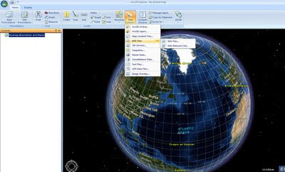
ArcGIS Online (Beta) - ArcGIS Explorer

Update: ESRI's answer to Google Earth is available here (login required)
ArcGIS Explorer

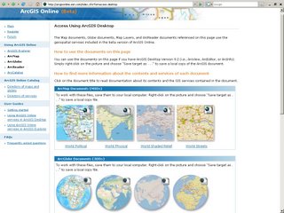
ESRI has finally released ArcGIS Online (Beta) for the ArcGIS 9.2 products

ArcGIS Online Beta

If your lucky enough to have 9.2 (Arc installed and running you will be able to use this service.
You are required to login (can use your existing ESRI account).

Take a look at the National Geographic Maps in ArcGIS 9.2
(yes mapperz helped make them)

"Using ArcGIS Online, you can:
  • Explore data for many digital worlds seamlessly in both 2D and 3D maps—for example using ArcGIS Explorer, the free 3D application for ArcGIS.
  • Create your own digital worlds in 2D and 3D by combining ArcGIS Online services with your local data and services from ArcGIS Server, ArcIMS, Open Geospatial Consortium WMS services, and KML Services.
  • Embed ArcGIS Online services into your own maps and applications and share the results with others.
  • Add user tasks from your own secure servers and fuse them with services from ArcGIS Online and other servers—for example, visibility modeling, proximity search, or demographic analysis."
ArcGIS Onlline can be used with the following software:

* ArcGIS Explorer 9.2
* ArcMap 9.2
* ArcGlobe 9.2
* ArcReader 9.2
* ArcCatalog 9.2

Labels: , , ,