->

31 May 2007

Google Developer Day 2007


http://code.google.com/events/developerday/uk-home.html

The Day to find out even more under the Google Empire.

If you cannot go - this will be streamed live on the web

http://googledeveloperday2007-uk.blogspot.com/2007/05/london-developer-day-to-be-streamed-on.html

here to the stream

Labels: , , , , ,

30 May 2007

Google Mapplets - Preview

Google are rolling out Google Maps API Mapplets


Google Mapplets are mini-applications that you can embed within the Google Maps site

Google Mapplets in Action
Here is a first example of a Mapplet in action. Notice the new tab next to 'My Maps'

link
http://maps.google.com/maps/mm?

mapprev=1&ie=UTF8&om=1&z=4

"Mapplets are mini-webpages that are served inside an IFrame within the Google Maps site. You can put anything inside this mini-webpage that you can put into a normal webpage, including HTML, Javascript, and Flash. Google provides a Javascript API that gives the Mapplet access to services such as manipulating the map, fetching remote content, and storing user preferences.

When a Mapplet is enabled by the user, Google's servers will fetch the Mapplet source code from your web server, and then serve it to the user from gmodules.com. To reduce the load on your server, gmodules.com will cache your source code for several hours."


Full Documentation on this is available here:
http://www.google.com/apis/maps/documentation
/mapplets/index.html

See some Mapplet Gadgets

This looks very promising in delivering your on live content on a google based map.
With the addition of buffering and geographical analysis of multiple types of data this becomes more of a geographical information system than a plain old map.

Describing content in visual form empowers people to understand their surroundings.

Mapperz

Labels: , ,

Street View on Google Maps

Street View on Google Maps
San Fran Google Maps Street View

The Five Cities with 'Street View' New!

Denver
Las Vegas
Miami
New York
San Francisco (of course)

Features are:


Blue outlines show roads where street view is available.

This icon shows where you are on the map. The green arrow points in the direction you're looking. You can drag the icon to navigate to a different location. You can also just click on a blue outlined road to go there.

Drag the street view to look around 360°. Use the arrow buttons to navigate down the street. You can also use the arrow keys on the keyboard.


Report Inappropriate Image
Google takes concerns about its services very seriously. Please use the link below to report concerns about an inappropriate street view.


Internet Explorer might need MSXML 3.0 SP7

Internet Explorer might need MSXML 3.0 SP7 for the 'Street View' to function correctly.

Fire Fox seems a bit quicker in displaying this function.

All ready there are some strange viewings
The headless man
The Street through the building
Doctor Who using his Tardis?


More on Tardis's

The option to rotate and slide linear east/west - a north/south option is available which is very useful. Only when zoomed out fully in Street View mode

East - West Slide1East - West Slide2

Seems there was no beta for this, is this a first for google?
Was everyone aware that they were photographed?

Mapperz

Labels: , , ,

29 May 2007

192.com Mapping - High Resolution Images

192.com Mapping - High Resolution Images

192.com St_Paul's Cathedral Hi Res

More Mapping Competition from 192.com - with transitional action from the cartographic map to aerial imagery a nice implementation.

The main advantage with this is that the aerial imagery is constant across the UK.
Google Maps, Microsoft Live Local, Multimap mapping has patchy areas that are poor resolution in places.

On par with Micosoft Live Local resolutions however the tiles appear faster in 192.com with the added transitional effect makes the user aware of the fact that data is loading.
Data source is cities revealed and overview mapping.

Mapperz back in the UK

more information on this at Guardian Unlimited: Technology

Labels: , , , ,

24 May 2007

The People’s Map (Beta)

The People’s Map (Beta) for the UK

Peoples Map Beta


The People’s Map is free for private and Non-Commercial use.

Layers available:
  1. The People's Map
  2. Get Mapping Imagery
  3. Out of Copyright Map

"The People's Map is a revolutionary new concept in mapping. Professional and Private users maintain the People's Map by providing update information using the editing suite. The information is checked and compiled into high quality cartographic maps at all scales with fair and straightforward licensing."


Terms of Use and Copyright Information here

Posted by Mapperz in Canada

Labels: , , , , ,

22 May 2007

BBC, Nokia & Ymogen = GeoStories

News has location
BBC, Nokia & Ymogen team up to create GeoStories

GeoStories is a project combining GPS, News and Innovation together. Students from Brighton University have started this unique project.

This is a very likely and useful way of reporting news and adding location to the story.


Geo-Stories Project
GeoStories uses Google Maps to show locations of events per story

"Ymogen are working with Nokia and BBC Innovation to produce Geo-Stories, an innovative 'citizen story' project, which explores how content (video, pictures and text) combined with location and time can most effectively be used to create crowd pulling stories."

Nokia N-series mobile phone(s) are used to store location and record video and geotagged photos

View the GeoStories

Posted by Mapperz in Canada

Labels: , , , , ,

20 May 2007

Yahoo Local UK Changes

Yahoo Local UK and Ireland Changes Mapping


Yahoo Local Map Static Yahoo Local Map Dynamic


Now uses Map24 to search locally


The maps are available either in a Static or Dynamic Mode. Search radius can be applied in static mode. Carefully with Firefox in dynamic mode as panning can cause firefox to close without warning (a map24 api bug?).


Blogged by Mapperz in Canada

Labels: , , , ,

14 May 2007

More International Geocoding from Google Maps API

Holiday Post
Geocoding in the API is now enabled for the following countries

  • Brazil
  • Portugal
  • Hungary
  • Poland
  • Czech Republic

More over on the official blog...
http://googlemapsapi.blogspot.com/2007/05/
looking-for-somewhere-in-brazil.html


Posted by Mapperz in Canada

Labels: , ,

07 May 2007

Twango - Multimedia in Google Earth
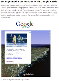
Twango - Multimedia in Google Earth

Twango content in Google Earth

How to use:

Install Google Earth

View geo-tagged media from the Twango community:
most popular media, most popular members (approx location), most recent media, most recent photos, most recent videos, most recent audio

Geo-tagged media from a particular channel:
Go to the channel page, click the Subscribe button, then click the icon on the popup.

View all geo-tagged media from a particular member:

Supported file types: 3g2, 3gp, 3gp2, 3gpp, 3gpp2, aac, aif, aifc, aiff, amr, asf, asr, asx, au, avi, bmp, cad, cmx, cod, css, dib, doc, dot, dtd, dwf, fla, flv, gif, ico, ief, ifo, ipx, jfif, jpe, jpeg, jpg, lsf, m1a, m1v, m3u, m4a, m4p, m4v, mdi, mid, midi, mov, movie, mp2, mp3, mp4, mpa, mpe, mpeg, mpg, mpp, mpv2, mqv, nsc, odf, odg, odp, ods, odt, pbm, pdf, pgm, png, pot, ppm, pps, ppt, psd, pub, qt, ra, ram, ras, rgb, rmi, rtf, rtx, scd, sit, snd, swf, tif, tiff, tsv, txt, vsd, vss, vst, vsx, vtx, wav, wax, wbmp, wm, wma, wml, wmp, wmv, wmx, wri, xbm, xla, xlc, xlm, xls, xlt, xlw, xml, xsd, xsl, xslt, z, zip.

More info:
http://blog.twango.com/

Labels: , , , ,

01 May 2007

ArcGIS Explorer (380 Build)

ArcGIS Explorer (380 Build) available for download from ESRI
(if you dare too)

ArcGIS Explorer Build 380
More Google Earth like, but slower.

"You can also change the appearance of ArcGIS Explorer by using skins. At present, each of the three skins that ship with ArcGIS Explorer has a distinct color scheme but does not differ in functionality. The skin color is determined by the color scheme active for your version of the operating system"
Rather have more functionality

Download ~(need an ESRI User Account to access the download)

ArcGIS Explorer Build 380 Crash

Yes it is a serious problem when you try opening a kmz file and it crashes.

ESRI please fix this.
And add support for Personal Geodatabases (your own files). (please)
They have shapefiles...

Labels: , , , ,