->

30 August 2011

FixMyTransport.com Beta

FixMyTransport.com Beta

FixMyTransport
Clean Mapping Interface to report problems with your routes (bus, train,tram/metro ferry)

FixMyTransport options

FixMyTransport was built to help people get common public transport problems resolved. It is targeted specifically at smaller problems such as persistently broken ticket machines, buses that always leave early, or silly rules that appear to do nothing but create inconvenience for travellers.

What is it all about?
At a basic level, FixMyTransport makes it easy for people to send problem reports to the companies or authorities responsible for those problems.

However, we know that simply sending an email often won't be enough to get a problem resolved. That's why we've built a complete system to make it easy to gather support other people, whether fellow commuters, colleagues or friends. We believe that this is worth doing because a transport company that doesn't respond to one person may very well respond to ten.

We hope that FixMyTransport will also help people by becoming part of the wider internet community of transport activists and campaigners. In particular, we hope that that community comes to see FixMyTransport as a place where experts and old hands can transfer their skills to people who have little or no experience of lobbying for change.


As well as being aimed at helping people to solve transport problems, FixMyTransport represents an experiment to discover whether a sufficiently well designed internet service can help tip people over the edge from grumbling about a problem to taking action to resolve it. We welcome your thoughts on how to measure whether or not we're succeeding.

Created by http://www.mysociety.org/

FixMyTransport.com Beta (with map interface openlayers/googlemaps)
http://www.fixmytransport.com/

Labels: , ,

25 August 2011

Storm Surge Simulator - Google Maps (for Miami Dade County)

Storm Surge Simulator - Google Maps (for Miami Dade County)


an update 26/08/2011 - Google Crisis Response set up a web mapping tool.

Hurricane Irene 2011 Google Crisis

Google Crisis Response has put together a Google Map for the 2011 Hurricane Season. The map currently shows the projected route of Hurricane Irene with the option of viewing a number of other layers on the map.

As well as viewing the forecast track of Hurricane Irene the map includes:
  • a cloud imagery layer from the Navy Research Lab
  • a layer showing coastal areas placed under tropical cyclone watches or warnings
  • evacuation routes from FEMA
  • a surge storm probability layer
  • real-time Stream Gage Data from USGS
Via Google Maps Mania


Original Post:
Storm Surge Simulator - Google Maps (for Miami Dade County)
Storm Surge Predictor Miami Dade County
Click on the Map and have the depth chart show the height of the predicted storm surge.
The Storm Surge Simulator is a public service provided by Florida International University

Please note:
The color-coded zones on the map illustrate a worst case snapshot for a hurricane category under "perfect" storm conditions.

Storm Surge Map (Simulator) Example
http://earl.cis.fiu.edu/gic/#lat=25.469412666272984&lon=-80.41580464050293

More information on this Storm Surge Simulator
http://www.miamidade.gov/OEM/storm-surge-simulator.asp

source:
http://blog.gisuser.com/2011/08/25/hurricane-tip-miami-dade-county-rolls-out-storm-surge-simulator/

Labels: , , , , ,

22 August 2011

Bing Maps Streetside - London UK

Bing Maps Streetside - London UK

Bing Maps Streetside - London UK
Streetside is now available for some parts of London, England

Bing Maps Streetside - Westminster Bridge London UK
Westminister Bridge, London Bus and London Eye Iconic Landmarks, but do not expect 'Google Streetview' type functionality this is more a slide-show of images.


More information on Streetside
http://www.microsoft.com/maps/en-GB/streetside.aspx

View Streetside - London UK (click the icon next to Traffic)
http://www.bing.com/maps/?v=2&cp=51.50085314131346~-0.12088798043215165&lvl=14&dir=0&sty=r&trfc=1&form=LMLTCC

cross-posted from BingMapsWatch

Labels: , , , ,

18 August 2011

Google Maps World Weather

Google Maps World Weather

Google Maps World Weather
Work in°C | °F or km/h | mph | m/s with the additional option to overlay clouds

Works well.

http://maps.google.com/maps?lci=weather


Video Introduction


source:
http://googleblog.blogspot.com/2011/08/rain-or-shine-see-weather-in-google.html

Labels: , ,

11 August 2011

USGS Historical Map Release

USGS Historical Map Release (Coming Soon)

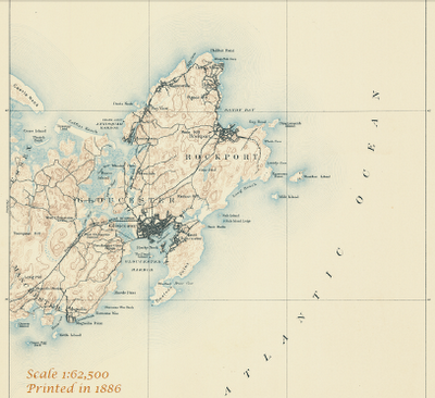
The USGS Historical Quadrangle Scanning Project (HQSP) is scanning all scales and all editions of approximately 250,000 topographic maps published by the U.S. Geological Survey (USGS) since the inception of the topographic mapping program in 1884.

USGS Map Locator
National Map Viewer can locate historical Maps for user to download

Because historical maps are stored in a limited number of collections and are not readily available, the USGS National Geospatial Program has begun a project to convert these historical printed topographic quadrangles to an electronic format (GeoTIFF and GeoPDF®). This project serves the dual purpose of creating a master catalog and digital archive copies of the irreplaceable collection of topographic maps in the USGS Reston Map Library as well as making the maps available for viewing and downloading from theUSGS Store and The National Map Viewer.
USGS Map 1886
One of the first Maps Created by USGS back in1886 will be available to download.

Source:
http://dracutlibrary.wordpress.com/2011/08/11/historical-maps/

Official PDF on the project
http://pubs.usgs.gov/fs/2011/3009/fs20113009_013111.pdf [PDF]

Link to the National Map Viewer [USGS Store]
http://store.usgs.gov/b2c_usgs/usgs/maplocator/%28ctype=areaDetails&xcm=r3standardpitrex_prd&carea=%24ROOT&layout=6_1_61_48&uiarea=2%29/.do

*Some maps will require a purchase - but most will be free of charge to download in GeoPDF and GeoTiff formats.


Labels: , , , , ,

04 August 2011

New v4 Map Channels

New v4 Map Channels

update 10/08/2011
Map Channels 'Map Place Maps' is now available for mobile phone.

"Mobile Place Maps are a quick and convenient method of providing a place map, plus the route to get there."

Map Channels Mobile Place Maps
Map Channels Mobile Place Maps is available here: http://www.mapchannels.com/MobilePlaceMaps.aspx


The successful Map Channels has been updated once again with some more useful tools.

"Map Channels lets users easily embed maps into websites and blogs. A number of tools are available to create maps from KML, GeoRSS or spreadsheet map data. A range of features and options let you customize the map appearance to meet a range of mapping needs. "

New v4 Map Channels

What is Ne
w?
  • Search facility is now powered by the Google Places API.
  • User can define a list of localities, giving quick links to map locations.
  • The footer bar can be customized by using a HTML template to show categories, layers and localities.
  • An information panel can be used in addition to the info window to display detailed place information.
User Interface Improvements
  • A map is provided to (optionally) set the initial map centre and zoom level.
  • A preview of the feed data is displayed (useful to spot if an incorrect feed url has been supplied).
  • Additional help for setting up a data feed.

Map Channels Editor (users are required to login to create a map)
New v4 Map Channels Editor

Map Channels

View the v4 Demo Map (as above)
http://www.mapchannels.com/Mc4Edit.aspx?id=mc4_demo_1_1

Follow Map Channels on Twitter

Labels: , , , ,

02 August 2011

Great British Picnics Map

Great British Picnics Map

Great British Picnics Map
Search and select picnic sites across the UK by environment or activity.

The Guardian newspaper (&partners) have produced a useful Google Map on Picnic
The newspaper and lastminute.com to ideas where to picnic. They have also worked with Enjoy England to create a Google Map based guide to great destinations in the .

The Guardian has now partnered with Country Life Butter to create a Google Maps guide to great picnic spots in the England, Wales, Scotland and Northern Ireland.

User and can search for a picnic sites or by activity, for example spots that are good for hikers, cyclists, bird watchers etc. Searches can be environment, such as by beach, riverside or country park.

The map can be viewed here:
http://www.guardian.co.uk/great-british-picnics


Labels: , , , , ,