->

13 September 2011

GIS Stack Exchange Blog (New)

The GIS Stack Exchange Community now has a GIS Blog for interesting topics and expansion of questions and events from http://gis.stackexchange.com/questions

If you are interested in GIS, Cartography,Web Mapping, Databases you can also join in and expand the knowledge sharing that answers questions quickly.

http://gis.blogoverflow.com/

GIS Community Blog


Welcome to the New GIS Blog Overflow, a new additional to GIS Stack Exchange Community

New content will be coming soon from community members from the GIS Stack Exchange.

Popular & reoccurring topics on GIS.SE, events related to GIS and the GIS.SE community with a random collection of posts by different authors will give a good wide cross-section of articles.

  • Popular questions will be also expanded.
  • Commercial and Open Source related GIS posts (includes beta software) are welcomed.
  • Community GIS News and Events will also be included

Potential Blog Author?

If you have a post that you would like to be included please contact the moderator (Mapperz or mapperz@gmail.com) by leaving a comment on this blog post.

Many thanks to the community users input who have made this blog possible

Labels: , , , ,

22 August 2011

Bing Maps Streetside - London UK

Bing Maps Streetside - London UK

Bing Maps Streetside - London UK
Streetside is now available for some parts of London, England

Bing Maps Streetside - Westminster Bridge London UK
Westminister Bridge, London Bus and London Eye Iconic Landmarks, but do not expect 'Google Streetview' type functionality this is more a slide-show of images.


More information on Streetside
http://www.microsoft.com/maps/en-GB/streetside.aspx

View Streetside - London UK (click the icon next to Traffic)
http://www.bing.com/maps/?v=2&cp=51.50085314131346~-0.12088798043215165&lvl=14&dir=0&sty=r&trfc=1&form=LMLTCC

cross-posted from BingMapsWatch

Labels: , , , ,

01 April 2011

OpenWhatEverMap

OpenWhatEverMap

'An Open Awsumnez Map'

http://openwhatevermap.org/

Labels: , , ,

07 June 2010

Bing Maps API 6.3 Released [AJAX] & REST Service

Lots Bing Maps news out this week. MoreBing Maps Apps and A New Bing Maps SDK

But more importantly for the developers who make these mapping applications

So this post covers Bing Maps API 6.3 Released [AJAX]
Bing Maps AJAX New Version 6.3

The new AJAX Control is version 6.3 and has the following changes:

Core functionality version of the map control. The Bing Maps AJAX Control is now available in both full functionality [6.3] and core functionality [light 6.3c] versions. If you do not have advanced mapping needs, you can enhance the performance of your map control application by using the core version of the latest map control. Note the version number (v=6.3c) for the core control which is now a slimmer down to an impressive 35kb. Meaning your maps will load much faster in the web browser.

Replace the Map Control Script to:
http://ecn.dev.virtualearth.net/mapcontrol/mapcontrol.ashx?v=6.3c&mkt=en-us


New Search and Geocode methods.
The new VEMap.Search Method and the VEMap.Geocode Method provide an easier way to return the most accurate search results. The current VE.Find Method has like 11 arguments for making your request more specific. If you know what you want and would rather slim your request down to 3 (query, callback, options).

Sample: (Geocode): map.Geocode(‘1 Microsoft Way, Redmond, WA’, findCallback, options);

Sample: (Search): map.Search(‘Fish Tacos in San Diego’, findCallback, options);

Drag-able Push-pins!
Drag-able pushpins. With the latest version of the Bing Maps AJAX Control, your pushpins become drag-able by simply setting the VEShape.Draggable Property of the pushpin to true. There are also optional events associated with the dragging motion that you can capture and fire off additional events such as search queries or grabbing pixels to convert to lat/lons.

Sample:
var pushpin = null;

pushpin = new VEShape(VEShapeType.Pushpin, map.GetCenter());
pushpin.Draggable = true;
pushpin.onstartdrag = StartDragHandler;

pushpin.ondrag = DragHandler;

pushpin.onenddrag = EndDragHandler


Good stuff for Bing Maps Platform developers! hope to see some cool applications coming from these new APIs.#Bing Map Apps API that was also released today. The Bing Map Apps API allows you to submit your Silverlight application to be published on Bing Maps.

New Bing Maps REST Service: (now with example requests and responses)

"This was in addition to the Bing Maps SOAP Service (via Windows Communication Foundation) and the AJAX Control that have been in use for years now. Today, we’re announcing a REST interface into those wonderful maps, aerial images, and geocoding and routing systems for your grubby coding hands to get all dirty. And, the beauty with REST is that you simply need to build URL queries and handle the JSON or XML responses."
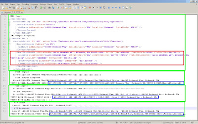
Bing Maps AJAX New Version 6.3 - REST Geocoding XML etc
Click for a bigger version: Geocoding by XML, PIPE|, TAB and CSV responses from BING Maps using REST method.
Blue and Red represent the actual geo-info you are after to plot markers on a map
Source:
http://msdn.microsoft.com/en-us/library/ff701732%28v=MSDN.10%29.aspx

http://www.bing.com/community/blogs/maps/archive/2010/06/07/rest-easy-bing-maps-has-you-covered.aspx


Links:
http://www.microsoft.com/maps/isdk/ajax/ not updated to 6.3 yet.
http://www.bing.com/community/blogs/maps/ 4 Bing Maps related posts:
New Developer Forum
http://www.bing.com/community/forums/12283.aspx not much here yet.

Labels: , , , , , ,

09 March 2010

New Google Geocoding Web Service

New Google Geocoding Web Service

The service is now 'not limited' but you are required to show the results on a Google Map.
Examples given to help user understand the importance of this update.
Lots of updated content and improvement from feedbackNew Service v3 Geocoding
  • Unlimited Usage*
  • Status Codes (in Plain English!)
  • Java Support (Parsing XML with XPath)
"*Note: the geocoding service may only be used in conjunction with a Google map; geocoding results without displaying them on a map is prohibited."
[2,500 requests may be sent to the Geocoding Web Service per day from a single IP address]

but purley for example based on the official example given
Geocoding London (UK)
http://maps.google.co.uk/maps/api/geocode/xml?address=London&sensor=false
New Google Geocoding Web Service

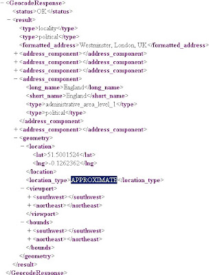
Reverse Geocoding 51.5001524,-0.1262362 (London)
http://maps.google.com/maps/api/geocode/xml?latlng=51.5001524,-0.1262362&sensor=false

Countries Support
http://spreadsheets.google.com/pub?key=p9pdwsai2hDMsLkXsoM05KQ&gid=1
Note: en-GB ENGLISH (GREAT BRITAIN) enabled

New Status Codes - now in Plain English
  • "OK" indicates that no errors occurred; the address was successfully parsed and at least one geocode was returned. example
  • "ZERO_RESULTS" indicates that the geocode was successful but returned no results. This may occur if the geocode was passed a non-existent address or a latlng in a remote location. example
  • "OVER_QUERY_LIMIT" indicates that you are over your quota. (your geocoding too fast!)
  • "REQUEST_DENIED" indicates that your request was denied, generally because of lack of a sensor parameter. example
  • "INVALID_REQUEST" generally indicates that the query (address or latlng) is missing. example
Now for the new content:

geometry contains the following information:

* location contains the geocoded latitude,longitude value. For normal address lookups, this field is typically the most important.
*location_type stores additional data about the specified location. The following values are currently supported:
o "ROOFTOP" indicates that the returned result is a precise geocode for which we have location information accurate down to street address precision.
o "RANGE_INTERPOLATED" indicates that the returned result reflects an approximation (usually on a road) interpolated between two precise points (such as intersections). Interpolated results are generally returned when rooftop geocodes are unavailable for a street address.
o "GEOMETRIC_CENTER" indicates that the returned result is the geometric center of a result such as a polyline (for example, a street) or polygon (region).
o "APPROXIMATE" indicates that the returned result is approximate.
* viewport contains the recommended viewport for displaying the returned result, specified as two latitude,longitude values defining the southwest and northeast corner of the viewport bounding box. Generally the viewport is used to frame a result when displaying it to a user.
* bounds (optionally returned) stores the bounding box which can fully contain the returned result.

Java Support
Parsing XML with XPath

Although it is not as lightweight as JSON, XML does provide more language support and more robust tools. Code for processing XML in Java, for example, is built into the javax.xml packages
please see http://code.google.com/apis/maps/documentation/geocoding/#XMLParsing for full details.

Full Documentation (updated)
http://code.google.com/apis/maps/documentation/geocoding/
Official Blog Post
http://googlegeodevelopers.blogspot.com/2010/03/introducing-new-google-geocoding-web.html
Mano Marks (Google Geo Developer Advocate)
http://randommarkers.blogspot.com/2010/03/client-side-geocoding-rocks.html

Full terms and conditions
http://code.google.com/apis/maps/terms.html#section_10_12
Maps API Terms
http://code.google.com/apis/maps/terms.html

Labels: , , , , , ,

12 February 2010

Google Maps Gets Beta Labs

Google Maps Gets Beta Labs
*Google Account signin required
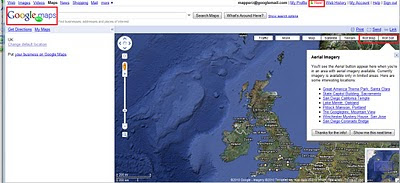
Google Map has now enabled Google Labs experiments that you can now add some nice and useful functionality.
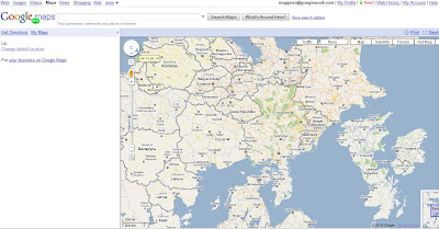
Google Maps Labs Rotated
A new prespective - Note the Map Labels (Text) are correct way up but the map is upsidedown.

Google Maps Labs New
New Features and Tools in Google Maps via Google Maps Labs - Rotate Map Types (Sat

Google Labs experiments that you can now add the following functionality:

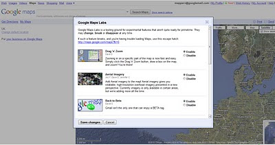
Drag 'n' Zoom
Zooming in on a specific part of the map is now fast and easy. Simply click the Drag 'n' Zoom button, draw a box on the map.
Google Maps Labs

Google Maps Labs Drag Zoom
New Button for Drag Zoom - Useful!

Click on the Green beaker New! to access the new features (simliar to gmail labs)

The Options are as follows
Aerial Imagery (Includes Rotate)
Add Aerial imagery to the map! Aerial imagery gives you rotatable, high-resolution overhead imagery presented in a new perspective. Currently imagery is only available in certain areas, but we're adding more all the time.

Back to Beta
Gmail isn't the only one that can enjoy a BETA tag.

Where in the World Game
Test your knowledge of world geography. Guess the name of the country from satellite imagery, and try to beat your top score.

Rotatable Maps
Tired of North always being up? Add rotatable map types and give East, West and South a fair go.

What's Around Here?
Adds a second search button that searches for "*", returning the top results in the current view. A great way to browse the map.

LatLng Tooltip
Displays a tooltip next to the mouse cursor showing the latlng directly underneath it.

LatLng Marker
Adds an option to the context menu that lets you drop a mini marker showing the latlng of the position that the cursor was pointing at when the context menu was evoked.

Smart Zoom
Ever zoom in too far and get the message "We don't have imagery at this zoom level"? Ensure you don't see it again, with Smart Zoom, which will check in advance what imagery exists, and ensure you can't zoom in beyond it.

source:
http://blogoscoped.com/archive/2010-02-12-n86.html
Related
http://googlemapsmania.blogspot.com/2010/02/google-maps-in-google-labs.html
Official Post
http://google-latlong.blogspot.com/2010/02/introducing-google-maps-labs-your.html

Labels: , , , , , ,

09 February 2010

New Street View Coverage for Norway & Finland

New Street View Coverage for Norway & Finland

update:
Canada has large coverage updates too
Canada Streetview Expands
New Canadian Coverage (substantial)
Yukon (Whitehorse)
Northewest Terroritories (YellowKnife)
Alberta (example Grande Prairie)
Bristish Columbia (example Prince George) (also includes Snow Mobile Streetview)
Saskatchewan (Example Prince Albert)
Manitoba (Lake Winniepeg)

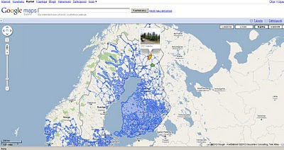
Google Maps Street view Finland
New Suomi (Finland) Street View Coverage

View the New Coverage
and drag the yellow pegman, drop on anywhere that is blue.


Google Maps Street view Norway

Norge (Norwegian) Street View Coverage

View the Norge Streetview


Also available on the Desktop via Google Earth see
http://www.gearthblog.com/blog/archives/2010/02/streetview_added_to_norway_and_finl.html

Source:
http://googlemapsmania.blogspot.com/2010/02/street-view-arrives-in-norway-finland.html

Labels: , , , , , , , ,

20 January 2010

Bing Maps Destination Maps (Map App)

Bing Destination Maps (Map App)

Bing Destination Maps Apps save styles
Bing Maps Destination Maps (Map App) European Map Style.

Bing Map Explorer moved out of beta today, and some new experimental 'Map Apps' have appeared in a continuing effort to make Bing Maps more widley used.

Bing Destination Maps Apps
The Maps are customised by dragging the edges of the rectangle.

Maps Apps are extension tools to Bing Maps they are only accessible in the sliverlight version.
A good link to observe this tools is
http://www.bing.com/community/blogs/maps/archive/2009/12/21/bing-maps-application-gallery-overview-new-apps.aspx

Desination Maps, now this is very new, though basic Map Types 'American' 'European', Sketchy (Pencil) and Treasure Maps Styles.


This App does have great potential if:
Legend can be added
Annotation/Text can be (Title, Comments)
Simple Arrows, Line,point polygons can be added.
Simple layer contol - move minor roads above major roads.

Destination Map Format Export JPEG
Basic Map - though the Destination Map App has good potential if it has a few more customising tools.

Sharing can be improved by allowing users to specify the size and currently only jpeg and pdf formats are available for export.

Will the Bing/Microsoft Research team work on this?

Current coverage:
  • USA
  • Canada
  • Mexico
Source:
http://www.bing.com/community/blogs/maps/archive/2010/01/19/new-bing-maps-application-destination-maps.aspx

Labels: , , , , , , ,

08 December 2009

Birds Eye View - Google Maps API - New

Birds Eye View - Google Maps API- Aerial Imagery
*limited coverage currently
**currently only available via the Google Maps API V2)

Users of Bing Maps (Virtual Earth/Live Maps fame) will recognised this maptype.

Birds Eye View Google Maps - New Map Mode
New Map Mode - Tilted Aerial Imagery comes to the Google Maps API.
(techies call it oblique aerial and its taken from aircraft from the side or front)
getmapping has a good set of examples
http://www2.getmapping.com/Services/Obliques


"Starting today [8th December 2009], developers will have access through the Google Maps API to high-resolution overhead imagery that is presented in a new aerial perspective. This is currently available in 2 spots in California: San Jose and San Diego. This new perspective gives users the ability to tilt their view of the world. In addition to seeing hotel rooftops like in our current "satellite" view, users can now see both the rooftop and sides of the hotel at an angle. In fact, users can rotate around all the sides of a hotel to get 4 different views from back to front"

2 Official Blog Posts
http://googlegeodevelopers.blogspot.com/2009/12/getting-better-view-with-maps-api-v2.html

http://google-latlong.blogspot.com/2009/12/changing-your-perspective.html

"What's great about this new imagery is that all of your existing data and Google Maps services like driving directions can be displayed on your map with no extra work. This is a result of a lot of code and computing power that reprojects the imagery to make it easy to overlay data on the map given lat/lon locations like in any other Google Map type. The result is a great user experience together with easy display of data on the map"

Documentation
http://code.google.com/apis/maps/documentation/introduction.html#AerialMapTypes

Examples:

Simple
http://code.google.com/apis/maps/documentation/examples/aerial-simple.html
Now with Auto-rotate
http://code.google.com/apis/maps/documentation/examples/aerial-rotation.html

@mapperz uber widescreen version (1200x800)
http://mapperz.googlepages.com/Aerial_RotateGoogle_Maps.html

Labels: , , , , ,

30 November 2009

OpenSteetMap Potlatch 2 Development Preview

OpenSteetMap Potlatch 2 Development Preview
"It's not just an online map editor - it's a Live Cartographic Online Editor"
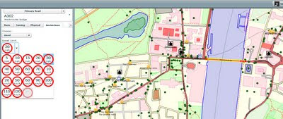
Potlach 2 Editor

OpenStreetMap users are getting a brand new online 'cartographic' editor in the form of Potlatch TWO (2.0)
Potlatch 2 is a complete rewrite.

Aim:

  • Speed

  • Ease-of-use

  • Flexibility

Four big new features :

1.New feature – friendly tagging system Potlatch 2 has a friendly, intuitive tagging system. The mapper can use graphical menus, dedicated fields, and icons to get the tagging just right – without the need to remember tag names and values.

Graphical Presets - no need to lookup or remember tags

Potlach 2 has a friendly, intuitive tagging system. The mapper can use graphical menus, dedicated fields, and icons to get the tagging just right – without the need to remember tag names and values.

2.New feature – 'What You See Is What You Get' (WYSIWYG) rendering Potlatch 2 has an all-new rendering engine far in advance of the current one.


Potlach 2 Editor MapCSS


source:http://www.opengeodata.org/2009/11/30/introducing-a-new-osm-editor-potlatch-2/
With road names, patterned fills, rotated icons, and much more,form a Cartographic editing experience can be like working live on the familiar Mapnik rendering, the cyclemap, Osmarender, or anything you like -making it much more approachable for the beginner.Thumbs ups for this!

3.Cascading Style Sheets - CSS but for Maps = MapCSS


Just like the tagging, the rendering is easy to customise. It uses a special form of CSS, called MapCSS, which lets you create wonderful-looking maps with just a few lines of text. The tagging and rendering together make Potlatch 2 ideal for ‘vertical’ mapping applications, such as a cycle-specific editor or a building/addressing editor. Stylesheets aren’t just about making the map look pretty: you can create stylesheets to help your mapping, such as one that highlights roads without names.
So if your only interested in Footpaths then only show footpaths


Because this integrates fully with MapCSS stylesheets, you can choose to temporarily hide background data, or show (say) only footpaths… whatever you like.

So Potlatch 2 will have an accompanying ‘OSM Guide’, explaining the basics with friendly, illustrated text. It will be concise, focused and clear.

4.New feature – vector background layer Mappers are working more and more with imports. But the approach until now has been to import data directly into the map – and many people have pointed out the problems this can lead to.Highly requested


Potlatch 2 will support vector background layers.

You can load OSM-formatted data from servers or files, and work on bringing it into the map the way you want, at your own pace.
Fully rewritten in ActionScript 3 Potlatch 2 is written in ActionScript 3, a Java-like language with an open source compiler and full docs available online. The Potlatch 2 source comes with instructions on getting started and is, of course, permissively licensed under the WTFPL.
Potlatch 2 thus far has been written by Dave Stubbs and Richard Fairhurst (Great Work). But we would love to see more people hacking on the source. There’s a potlatch-dev mailing list especially for this.

New Existing Features likely to be coming:
Some other features, like Yahoo and tiled backgrounds, are finished but not currently exposed through the editor: they’ll be along shortly. Others, such as GPS track support, the Beginners’ Guide and the vector background layer are not coded yet but are intended for the initial release.Load Import Shapefile? Export Shapefile options?? Would be good. [Hint]


Potlatch 1 has some three years of development behind it, of course, and much of this feature set has not yet been ported to Potlatch 2. There’ll be countless little UI tweaks (no keyboard shortcuts yet, for example!); and as you’d expect for an in-development version, performance can sometimes be sluggish and there’s a lot of optimisations we’d like to do.
But with work progressing so fast, this seemed a great time to talk about it. Both the tagging system and the renderer are enormously flexible and we’d like to see people hacking on them as soon as possible.
Live Version
at:http://www.geowiki.com/potlatch2/
Renderer alone at:
http://www.geowiki.com/halcyon/

Should you want to try a particular area, just put the lat and lon in the URL like this:


http://www.geowiki.com/potlatch2/?lat=52.2&lon=0.1http://www.geowiki.com/halcyon/?lat=52.2&lon=0.1

Source Code is at:http://trac.openstreetmap.org/browser/applications/editors/potlatch2

More on MapCSS and documentation at:http://wiki.openstreetmap.org/wiki/MapCSS

Full Credit and Original Post
http://www.opengeodata.org/2009/11/30/introducing-a-new-osm-editor-potlatch-2/

Labels: , , , , , , ,

08 October 2009

Google StreetView for Canadian Cities - New!

Google StreetView for Canadian Cities - New!

Seems a long time waiting but finally Google Street View comes to Canada.
Google Street View Canada

The service is now available in much of the Greater Toronto Area and in Vancouver and the surrounding area, north to Whistler (2010 Winter Olympics Venues) and east to Chilliwack, British Columbia


Google Street View is also available in the Ontario cities of Hamilton, Kitchener, Waterloo, Ottawa also Calgary, Canmore, Banff and Lake Louise in Alberta, Montreal and surroundings, Quebec City and finally Halifax in Nova Scotia.


Source and embedded StreetView Scenes available at
http://googlemapsmania.blogspot.com/2009/10/street-view-comes-to-canada.html

Don't forget you can embedded your own StreetView tours easily with
http://www.streetcities.com/

Labels: , , , , , ,

09 September 2009

New Canadian Toporama WMS service - Examples

New Canadian Toporama WMS service - Examples

update:12/09/2009

Geospatial provides a little more information on ftp access {bulk downloads} to map data.
http://geospatial.blogs.com/geospatial/2009/09/nrcan-wms-service-for-canadian-vector-topo-maps.html


new link:
http://tinyurl.com/nuseox
(newer code)

WMS [Web Mapping Service]
is not new - in GIS and Technology terms is old.
But there are plenty of services, organisations, governments out there that do serve their content via this format.

So why this post - Well there was a Google Maps API Thread that was becoming very interesting:
"mentionned last week that canadian topo maps (NRCAN) are of poor quality. This is true. But a new service have been implemented in may by NRCAN to replace it. It seems this introduction passed unnoticed so far. I myself searched for a long time and to find information about this new service. NRCAN has introduced in may the Toporama WMS service. This gives access to the new CANTOPO, the new generation of Topographic Maps (1 :50,000) produced by NRCAN. Theses maps are in vector format. The availability of this new vector format for canadian topo maps gives us more precision and clarity as compared to the old Raster Maps format who where a scan of the Paper Maps. Texts describing rivers and local points of interest do not anymore collapse when zooming to lower levels. The map is also of higher quality at higher zoom level. And
the information shown on the maps is adapted to the zoom levels. "
PierreB

Then the talented google map api programmer PapaBear picked up on this and quickly developed this:
Canada Vector WMS Maps - Service - Google Map Mashup
the new generation of Topographic Maps from CANTOPO
The quality and content from this dataset is rich in detail, contours, very small lakes, buildings, rail road etc

Though the full credit goes to PapaBear for the example and PierreB for thier knowledge and skills to put this together in a very short space of time.

"This map is of a station (survey marker) very near the border in
Maine. It should open with USGS topo map type. These topos usually
overlap the border and show a short distance into Canada (usually to
the next 7.5 or 15 minutes of longitide, depending on the scale).

The map type is changed with the selector in the upper right. I have
kept the old raster version from NR canada (type "CanRas") as well as
the new vector maps (type "CanVec").

You can compare the USGS topos and the 2 Canadian types for the same
locale. The USGS map tiles are also raster data (and these have been
know to have missing areas and occasional mis-registration) but they
are higher resolution scans than the old NR Canada tiles..

The topography is not too interesting, since it's a swampy area, but
nevertheless the different map type are all visible. "

If you want to see a working example then go to:
http://members.bellatlantic.net/~vze2h6gy/papabear/BM_Station_GMap.html#FILE=Maine_Peaks.js&index=QF1769&title=1&width=960&height=720&showrm=1

{note: this is a testing environment and change be moved or changed without notice}

But hopefully users will be impressed with the resources and hopefully make use of the wms services still out there.

Well done.

Labels: , , , , , , ,

22 July 2009

New Map of Somerset

New Map of Somerset

update:9am 22/07/09

All Points Blog debates whether this "Tube Style Map for Tourism - Does this Make Sense?"

http://apb.directionsmag.com/archives/6170-Tube-Style-Map-for-Tourism-Does-this-Make-Sense.html

Wiki Entry - http://en.wikipedia.org/wiki/Topological_map
"a map that has been simplified so that only vital information remains and unnecessary detail has been removed. These maps lack scale, and distance and direction are subject to change and variation, but the relationship between points is maintained"


"A London Tube-style map has been created detailing major tourist attractions in Somerset.

More than 100 museums, stately homes, castles, gardens, archaeological sites and railways feature on seven lines."

BBC News [Somerset]

New Topological Map of Somerset County
New topological map representing of things to do and see in Somerset.

Topographical Map of Somerset County
Traditional 'topographical representation' map of Somerset
Image Source:http://www.visitsomerset.co.uk/


"It aims to promote public access to, and interest in, the two areas’ heritage."

"the goal is to preserve, protect, promote and interpret the heritage of Somerset"

For more information go to the Visit Somerset
or visit:
http://www.youtube.com/somersetmuseums

source:
http://www.visitsomerset.co.uk/dbimgs/Somerset%20Routes%20Booklet.pdf

[pdf]
News Source:
http://news.bbc.co.uk/1/hi/england/somerset/8160773.stm

Labels: , , , , , ,

19 June 2009

192.com Mapping Updates

192.com Mapping Updates

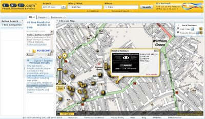
"New on 192.com is ability to see the list of people or businesses that matched your search criteria highlighted on the map. This makes it even easier to identify the person or business you are looking for. For example, you may know that a person definitely lives in the midlands. Or you may be looking for a business that is located on the high street or close to the tube.

You can also use the Locations grouping on the Refine Search panel to filter by any area in the UK, from country level right down to postcode."

What's New on 192.com

Image 192.com: Search results for People or Businesses are now mapped.

Other new searches:

You can now search all of 192.com from any page of the site. You can choose to Search All or select a particular section that you are interested in including:

  • People
  • Businesses
  • Places
  • Property prices
  • Electoral roll
  • Directors
  • Family records
  • Company credit reports
  • Visual timelines
  • Websites Mapped
Websites are now geocoded to a real business locations.

What's New on 192.com on the Map
Websites are now geocoded to real world locations

Websites now mapped on 192.com
Filtering by Website on a map - unique to 192.com

http://www.192.com/content/help/whatsnew/#maps


Try it out:
http://www.192.com/all/search/

Source:
http://blog.192.com/?p=21

Labels: , , , , , , ,

20 May 2009

Google Maps Data API - New!

Google Maps Data API - New!
(so new not had chance to play with it!)

Google Maps Data API - New!

Why Use the Google Maps Data API?

  • Storage scales simply with usage. You shouldn't have to worry about maintaining a data store to build a cool Google Maps mashup. Focus on building the client, and we'll provide hosting and bandwidth for free.
  • Geodata is accessible across platforms and devices. With many client libraries and clients, accessing stored geodata is possible from anywhere, whether it's on the web, a mobile phone, a 3D application, or even a command line.
  • Realtime geodata requires realtime indexing. For a lot of geographic content, freshness is important. Geodata from the Google Maps Data API can be instantly indexed and made searchable in Google Maps.
  • Rendering geodata is better and faster with the right tools. Through JavaScript, Flash, 3D, static images and more, we'll continue to provide better ways to render your content to meet platform and latency demands.

Some Applications That Have Already Been Made:

  • My Maps Editor for Android allows users to create and edit personalized maps from an Android mobile phone. Integration with the phone's location and camera makes it easy to document a trip with photos and text on a map.
  • ConnectorLocal is a service that informs users about the places where they live, work and visit by gathering trusted hyperlocal information from many sources. Using the Google Maps Data API, ConnectorLocal makes it easy for users to import and export geodata in and out of Google Maps, and also improves their ability to have data indexed in Google Maps for searching.
  • My Tracks enables Android mobile phone users to record GPS tracks and view live statistics while jogging, biking, or participating in other outdoor activities. Stored with Google Maps Data API, these tracks can be accessed, edited and shared using the My Maps feature in Google Maps.
  • Platial, a social mapping service for people and places, uses the Google Maps API to host geodata for community maps on both Platial and Frappr.
More information and Source:
http://googlegeodevelopers.blogspot.com/2009/05/
introducing-google-maps-data-api-in.html

Labels: , , , ,

28 March 2009

Street Tours - Street View New!

Street Tours - Street View New!


Map Channels have been busy once again and produced a handy set of tools where you can record Google Street View sightings in your own custom map and then embed on to your website.

"Create your own mapped Google Street View tours - embed onto your website"


Street View Tours - Coverage Availability
Blue areas indicate where Street View is currently available.

Future coverage are likely to expand for the UK and new areas such Germany, Belgium and Canada will be introduced.

related links:
http://streetcities.com/Main.aspx
http://www.mashedworld.com/Home.aspx [Street Tours available here]
http://www.mapchannels.com/DualMaps.aspx

Labels: , , ,

25 February 2009

Google Map Maker Directions - New!

Google Map Maker Directions - New!

Last week, Google switched on the MapMaker Tiles for API developers. See previous post (12th Feb '09).

MapMaker is based on user generated content.

"With Google Map Maker, you can become a citizen cartographer and help improve the quality of maps and local information in your region. You are invited to map the world with us!"

Now those tiles have graduated to Google Maps. 31 countries (of 160+) have made it so far - though this is likely to expand through the year and beyond.

The Full List is available
http://sites.google.com/site/mapmakeruserhelp/countries-on-google-maps

But wait there is more...

Driving Directions in MapMaker New!
(but use with caution)
Google Map Maker Directions - New
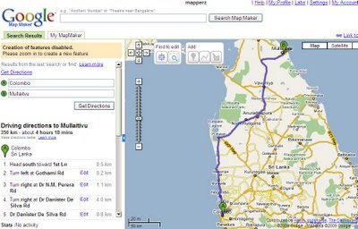
Directions in a simpler form have been enabled, usually only the likes of TeleAtlas navigation is used on Google maps but now user contributed content is being used for the first time available in Map Maker Mode only at present [google login required].

Some of the countries do not have the simplified driving directions available.

Here is a working example
http://www.google.com/mapmaker?hl=en&ctype=0&saddr=Quetta&daddr=Zhob&dirflg=&gw=56&ll=30.192618,68.895264&spn=4.756322,7.426758&z=7
but don't expect this to be the shortest route.

Here is a better example
http://www.google.com/mapmaker?hl=en&ctype=0&saddr=Colombo&daddr=Mullaitvu&dirflg=&gw=56&ll=8.070086,80.330403&spn=2.724552,3.713379&z=8

Source:
http://sites.google.com/site/mapmakeruserhelp/using-directions

Labels: , , , , ,

02 February 2009

Google Earth 5 (Beta) More New Layers

Google Earth 5 (Beta) More New Layers

KML Update:
The KML documentation has now been updated for users wanting to create tours underwater.
http://code.google.com/apis/kml/documentation/kmlreference.html#kmlextensions

Official Posts
http://google-latlong.blogspot.com/2009/02/new-in-google-earth-50-historical.html

http://google-latlong.blogspot.com/2009/02/deep-dive-into-ocean-in-google-earth.html

http://googlegeodevelopers.blogspot.com/2009/02/ocean-time-machine-and-touring-new-kml.html

Google Earth 5 New Layers
Google Earth 5 - Real-time buoys data provides current conditions the ocean.

"If you've ever wondered how your neighborhood has changed throughout time, Google Earth now gives you access to the past. With a simple click, check out suburban sprawl, melting ice caps, coastal erosion, and more."

Google Earth 5 New Layers

New toolbar gives easier access to control features
Dive beneath the surface of the ocean

In the new ocean layer, you can plunge all the way to the floor of the sea, view exclusive content from partners like BBC and National Geographic, and explore 3D shipwrecks like the Titanic.

  • Dive beneath the surface and visit the deepest part of the ocean, the Mariana Trench
  • Explore the ocean with top marine experts, including National Geographic
  • Learn about ocean observations, climate change, and endangered species
  • Discover new places including surf, dive, and travel hotspots and shipwrecks
Track and share your paths with others

Take placemarks a step further and record a free-form tour in Google Earth. Simply turn on the touring feature, press record, and see the world. You can even add a soundtrack or narration to personalize the journey.

Please Visit the Excellent http://www.gearthblog.com

for more detailed and in depth information on the newest release of Google Earth.

Historical Imagery
New Google Mars
New Google Ocean

To Download Google Earth 5 go:
http://earth.google.com/ocean/
**High Speed Broadband recommended if using this free product.

Labels: , , , , ,

23 January 2009

Interactive Google Maps API - Playground - New!

Interactive Google Maps API - Playground - New!

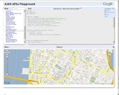
Confused by code? Want to see how the pieces of code fit together to create Google Maps API mashups? Interactive fully editable code and then click Run to see the result.

Interactive Google Maps API Playground

Code Menu button allows the user to save the source
Export creates an id and uses the 'http://savedbythegoog.appspot.com' (Google App Engine) to make a page live, login and and this is saved in a 'Saved Code' Menu

Custom Saved AJAX Playground
Saved Code [requires login]

Here is an excellent new section to the Google Maps API Documentation http://code.google.com/apis/maps/documentation/reference.html Code Samples > Code Playground - New!

Hopefully this inspires more developers and people interested in creating their own maps based on Google Maps. This new interactive page gives users a jump start in the right direction.


Virtual Earth has had an Interactive SDK page for quite a while now available at:
http://dev.live.com/Virtualearth/sdk/

(not editable code unless copy and paste into an editor (notepad or dreamweaver etc))

The Google Interactive Playground is now also available for:

Visualization API (includes Chart API)
Search API
Language API (Translate)
Blogger Data API
Libraries API
Earth API
Feeds API
Calendar Data API


Source:
http://google-code-updates.blogspot.com/2009/01/playing-around-with-googles-ajax-apis.html

Labels: , , , ,

20 January 2009

Google Bathymetric Earth

Google Bathymetric Earth

Update 23/01/2009
This Bathymetry is now available in Google Maps - Satellite Mode

Google Maps now has the Bathymetry

See it here
http://maps.google.co.uk/?ie=UTF8&ll=51.890054,-26.542969&spn=35.807862,79.101563&t=h&z=4


Google Earth Bathymetry Pacific
Google Earth Bathymetry
Bathymetry has now been made available in Google Earth - Looks good from along way out but when you zoom in it becomes a little less useful.

But when the terrain [3D] option is switched on it doesn't reflect the true depth of the oceans, a little disappointing. Maybe a future enhancement...

Now there are a few good blogs more involved with Google Earth [Users and Developers]

Here are their thoughts - for more detailed information and comments visit the blog sites.
"Hopefully they can vastly improve the edge matching, aka the coastline, then I wont mind."
Barry Hunter Nearby Blog 18/01/2009/01

"But what this layer also hints at is that the mooted and hoped-for true 3D ocean landscape is likely not arriving anytime soon to Google Earth. A true bathymetry DEM for the globe would have been a real feat, but instead we'll be looking at a 2D rendering of it for a while yet."
Stefan Green Ogle Earth 20/01/2009

"some island atolls which had low resolution data look less "visible" in the new imagery. Particularly noticeable are the Maldives, also St. Helens, Montagu Island, and many other islands now show "floor" instead of the islands"
Frank Taylor - Google Earth Blog 17/01/2009


If you don't have Google Earth [available for Mac & PC] you can download it for free from
http://earth.google.com/

It's been a little while since the last update to the software, so expect a new version in the near future.
Mapperz

Labels: , , ,