->

26 October 2010

Evolution: European OpenStreetMap

Evolution: European OpenStreetMap

Evolution of European OpenStreetMap coverage from skobblertutorials on Vimeo.

Hence why Mapquest(Open) and Bing Maps (OSM App) are becoming more mainstream

Labels: , , , , ,

10 May 2010

Global Action Atlas by National Geographic

Global Action Atlas by National Geographic

Global Action Atlas by National Geographic. The application allows users to peer into areas where our planet needs help. National Geographic and Bing Maps invite you to support efforts across the globe to help people in need, protect plants and animals, usands of others who are donating, volunteering, and sharing knowledge on behalf of community-based projects working to solve global challenges.

National Geographic Global Action Atlas Bing Map
"The Global Action Atlas spotlights hundreds of local, cause-related projects from around the world to a large audience of concerned citizens, giving individuals opportunities to take action by donating, volunteering, advocating, and sharing information. The Atlas enhances and extends the mission of the National Geographic Society"

Themes of interest include Conservation, Humanitarian Affairs, Cultures, Exploration, Climate Change and Energy.

Global Action Atlas

  • Conservation: Includes categories on animals and plants; fresh water; landscapes; migrations and corridors; and oceans and coastal areas.
  • Climate Change: Focuses on projects having to do with forest conservation and management; renewable energy; reforestation; and ocean impacts.
  • Cultures: Features projects focusing on preserving endangered languages; cultural preservation; archeology; and indigenous rights.
  • Energy: Focuses on technology; energy efficiency; and energy investment.
  • Exploration: Focuses on taking action to help preserve our planet; to explore its mysteries through sustainable travel; and to raise awareness about cultures and environments, and science and adventure projects.
  • Humanitarian Affairs: Includes projects focusing on water and sanitation; emergency relief; health; education; empowering women; and poverty and hunger.

View the Global Action Atlas - http://www.actionatlas.org/map

source:http://www.bing.com/community/blogs/maps/archive/2010/05/10/new-bing-maps-application-global-action-atlas.aspx

Labels: , , ,

22 March 2010

Online Spatial Database Clouds - SQL Azure

Online Spatial Database Clouds - SQL Azure
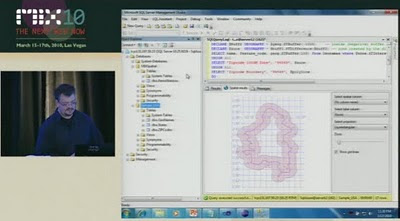
(spatial database support coming due to demand of user feedback)

SQL Azure Spatial POI Along Route
Using a Spatial database (SQL Azure) to find Gas (petrol) Stations along a route.
New Functionality - Azure Spatial Database Support using cloud computing related topic - http://en.wikipedia.org/wiki/SQL_Azure


Last Wednesday (March 17th), Dave Robinson of the SQL Azure Team announced upcoming support for spatial data in SQL Azure. You can view the announcement at the MIX Conference in the video of Dave’s presentation, Building Web Applications with Microsoft SQL Azure (go to 18:40 on the timeline for the start of the spatial data portion of his talk).
SQL Azure - Spatial Buffer
Spatial buffering a polyline - but across the web (not local database) - Windows SQL Azure will have spatial capabilities - to be released April 2010.

"SQL Azure provides a highly available and scalable relational database engine in the cloud. In this demo-intensive and interactive session, learn how to quickly build web applications with SQL Azure Databases and familiar web technologies. We demonstrate how you can quickly provision, build and populate a new SQL Azure database directly from your web browser. Also, see firsthand several new enhancements we are adding to SQL Azure based on the feedback we’ve received from the community since launching the service earlier this year."

This uses the same technology as Microsoft SQL 2008 Server
basically it supports latitude and longitude.

A "Flat Earth" (GEOMETRY or planar) data type represents geospatial data which has been projected from its native, spherical, coordinate system into a plane.
A "Round Earth" data type (GEOGRAPHY) uses an ellipsoidal model in which the Earth is defined as a single continuous entity.

source:
Video
http://live.visitmix.com/MIX10/Sessions/SVC07 (46.45) jump to 18.36if have no time.

Related blog
http://blogs.msdn.com/edkatibah/archive/2010/03/21/spatial-data-support-coming-to-sql-azure.aspx

SQL Azure Labs
http://blogs.msdn.com/sqlazure/archive/2010/03/19/9981936.aspx

Labels: , , , , , , , ,

17 March 2010

Worldwide Telescope (WWT) now in Bing Maps

Worldwide Telescope (WWT) now in Bing Maps [Preview mode]

The Sky at night (and day) in Bing Maps Explore

With the new Bing Maps Worldwide Telescope (WWT) App you can explore the constellations and other known space objects just like you would navigate through a regular Bing Maps.Worldwide Telescope Preview in Bing Maps
To access this use the "Map Apps" and choose Worldwide Telescope

Drag Telescope Icon Preview in Bing Maps
Drag the Telescope image to a location on the map you want to view (this sets the view up as "looking up" from that point from the Earth)

Worldwide Planets and charts
Exploring Planets is made easy from the data catalogue on the left hand side in the legend panel and click the very small "fly to" links. Zooming is very fast but not quite light speed.

View the Sky in Bing Maps
http://www.bing.com/maps/explore
Select >Maps Apps >Worldwide Telescope

For much more details and vast about of pulling tons of collections from the Worldwide Telescope Community including Constellations, Solar System, All-Sky Surveys, Spitzer Studies, Chandra Studies, Hubble Studies, Astrophotography, Radio Studies, NOAO Studies, Gemini Studies, Messier Catalog, Planets/Moons, Earth (Bing!), Panoramas, and Tours.
Then go to:
http://www.bing.com/community/blogs/maps/archive/2010/03/10/new-bing-maps-application-worldwide-telescope.aspx

Labels: , , , , , , , , ,

05 February 2010

'Eye on Earth' EEA and Microsoft Bing Mapping

'Eye on Earth' EEA and Microsoft Bing Mapping

Green EU citizens are being encouraged to contribute their own environmental observations to a website.

The Eye on Earth platform is a joint venture between the European Environment Agency (EEA) and Microsoft.

Eye On Earth Bing Map

Features:

  • Air Quality
  • Air Quality Model
  • Bathing Waters

1 is Very Good (Dark Green)
5 is Very Bad (Red)

Overlaying Air Quality data from Official EEA sources and from 'user' feedback using Bing Maps.

An impressive language support exists for covering all European Languages.


View Eye on Earth - http://eyeonearth.cloudapp.net/

*The project makes use of Microsoft mapping software and Windows Azure - the "cloud"-based operating system.

Room for expansion:

"The EEA's future ambitions for the site stretch beyond water and air monitoring."

source:

http://news.bbc.co.uk/1/hi/technology/8499059.stm


Labels: , , , , , , ,

20 January 2010

Bing Maps Destination Maps (Map App)

Bing Destination Maps (Map App)

Bing Destination Maps Apps save styles
Bing Maps Destination Maps (Map App) European Map Style.

Bing Map Explorer moved out of beta today, and some new experimental 'Map Apps' have appeared in a continuing effort to make Bing Maps more widley used.

Bing Destination Maps Apps
The Maps are customised by dragging the edges of the rectangle.

Maps Apps are extension tools to Bing Maps they are only accessible in the sliverlight version.
A good link to observe this tools is
http://www.bing.com/community/blogs/maps/archive/2009/12/21/bing-maps-application-gallery-overview-new-apps.aspx

Desination Maps, now this is very new, though basic Map Types 'American' 'European', Sketchy (Pencil) and Treasure Maps Styles.


This App does have great potential if:
Legend can be added
Annotation/Text can be (Title, Comments)
Simple Arrows, Line,point polygons can be added.
Simple layer contol - move minor roads above major roads.

Destination Map Format Export JPEG
Basic Map - though the Destination Map App has good potential if it has a few more customising tools.

Sharing can be improved by allowing users to specify the size and currently only jpeg and pdf formats are available for export.

Will the Bing/Microsoft Research team work on this?

Current coverage:
  • USA
  • Canada
  • Mexico
Source:
http://www.bing.com/community/blogs/maps/archive/2010/01/19/new-bing-maps-application-destination-maps.aspx

Labels: , , , , , , ,

15 January 2010

New Bing Streetside Coverage: Vancouver and Whistler

New Bing Streetside Coverage: Vancouver and Whistler for the Winter Olympics 2010

Streetside Bing Maps Vancouver
Blue represents the Bing Streetside coverage for Vancouver show here.

Streetside Bing Maps Vancouver
Downtown Vancouver, lots of big features gearing up the Winter Olympics 2010 will be held on 12th–28th February.

Streetside Bing Maps Whistler
Whistler is also in the streetside coverage. Lot of building and construction works in preparation of the big events next month.

Google also have Streetview Coverage of Vancouver & Whistler

View Bing New Streetside in Vancouver
http://www.bing.com/maps/explore/#5872/lat=49.282699&lon=-123.119823&alt=13.53&z=30&h=44.9&p=11.7&pid=5082/5003/0.5071=WNB&1.6002=q:Vancouver:lat:51.5120151209378:long:0&o=&a=0:1&n=0

Related links
http://www.vancouver2010.com/

http://en.wikipedia.org/wiki/2010_Winter_Olympics

Previous Post
http://mapperz.blogspot.com/2009/12/big-street-view-update-for-canada.html

Source:
http://www.bing.com/toolbox/blogs/maps/archive/2010/01/15/new-streetside-coverage-vancouver-and-whistler.aspx

Labels: , , , , ,

14 January 2010

Edmonton Opens Up City Data

Edmonton Opens Up City Data

The City of Edmonton in Alberta, Canada is following suit of Vancouver and Toronto and opening up city (public) data.

Data available now (more available after review of the community preview Feb 2010).
  • 2009 Census - Age and Gender
  • 2009 Census - Dwelling Unit Ownership
  • Bus Stops Edmonton Transit Locations
  • City Council Meeting Schedule
  • City Parks Locations of various City parks in Edmonton
  • Community League Centres Locations in Edmonton
  • Locations of all Fire stations in Edmonton
  • Locations of historical buildings in Edmonton
  • List of Planned Road Closures throughout the City of Edmonton
  • Police Stations Locations in Edmonton
  • Locations of School buildings in Edmonton

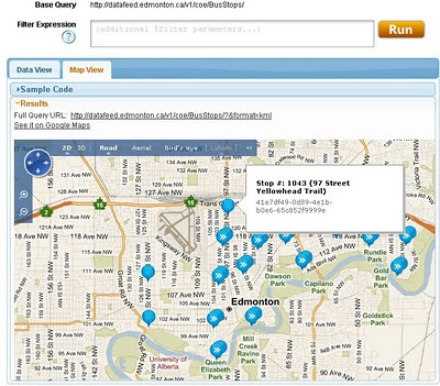
Though Edmonton take it a stage further and provide feeds and data overlay map ready so users can quickly make use of the data.

Edmonton Bing map
Default View of Bus Stops Overlay on the Edmonton City of Edmonton Website

Getting to the Data
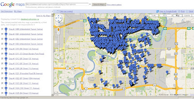
Edmonton KML
This example show the direct feed http://datafeed.edmonton.ca/v1/coe/BusStops/ as a KML (Google Earth) file loaded directly on Google Maps.
To view this Data as above - http://maps.google.com/?q=http://datafeed.edmonton.ca/v1/coe/BusStops/?format=kml

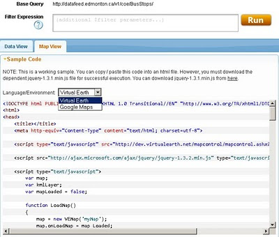
There is a stage futher, not only do City of Edmonton provide Scripts ready made so it makes it much easier for non programmers to create their own web maps.
Edmonton bing map source
Default is Bing (Virtual Earth) Maps though drop-down Language Environment reveals Google Maps API source code.
Mapperz edited mashup
This a mapperz example taken from the code above. Though there are two important changes for the examples to work.
1. jquery-1.3.1.min.js needs to be fully mapped to your server/website
2.Google Maps API requires a specific API Key for YOUR site (API Key signup)

Other changes mapperz made are simply moving the latitude and longitude to centre on Edmonton and not Washington DC.

Links - and Well done to the City of Edmonton making this available.
http://data.edmonton.ca/

mapperz version (tweaked to work)
http://mapperz.googlepages.com/edmonton_google_map_source.html

source:
http://www.calgaryherald.com/Edmonton+releases+downloadable+databases/2438135/story.html

Labels: , , , , , , ,

11 January 2010

Switch Maps (Google,Yahoo,OSM, Bing...) in One Map

Switch Maps (Google,Yahoo,OSM, Bing...) in One Map

Map Channels have released Switch Maps

Switch Maps by Map Channels
Switch Maps - Straight forward, easy to use and embed in your website or blog.
(Just copy and paste the code)

Switch Maps allow you to create a map that contains:
  • Google Maps
  • Google Earth (3D Globe) - plugin required
  • Street View
  • Bing Maps
  • Bing Maps - Bird's Eye View
  • Open Street Map
  • Yahoo Maps.
Creating a map is very easy select your map type then customise the map controls and set the width & height of your map.
Then use the 'Update' Button then Switch Maps creates the code that will allow you to embed your map in a website or blog.


Try Switching Map modes: Useful if one map type doesn't coverage your area another will.

Switch Maps also includes the option to include layers that show user photos from Panoramio and Picasa.
You can see some of the many map views available in Switch Maps in the Switch Maps Gallery.

Related links:
http://googlemapsmania.blogspot.com/2010/01/google-maps-plus-some.html
http://www.mapchannels.com/SwitchMaps.aspx
http://www.mapchannels.com/News.aspx

Well done to Map Channels on creating this excellent and versatile map creation tool.

Labels: , , , , ,

03 December 2009

BING Maps Explore (Streetside)

BING Maps Explore (Streetside)
*Sliverlight required & in beta
**Streetside mode is in some USA Cities only currently

BING Maps Explore Streetside
Looks familiar to Google StreetView but is a light blue indicating 'StreetSide' coverage.

BING Maps Explore Streetside - Streetside Mode
Streetside mode - has similar features to streetview, controls are slightly different.

BING Maps Explore Map Apps
Apps for your BING Maps - Nearby App (useful), Traffic, Twitter App displays geo-tweets, many more to explore.

BING MAPS BETA NEARBY CLUSTER MARKERS
Nearby Map App- Markers(Icons) group in clusters when there is not enough space to display all markers at zoom levels.

BING MAPS BETA STREETSIDE
BING Maps Explore has new controls - automatic 'finds' the best map mode for your zoom level

try it
http://www.bing.com/maps/explore/

warning to firefox users - can cause memory leaks and freeze up your browser.

source:
http://www.bing.com/community/blogs/maps/archive/2009/12/02/bing-maps-adds-streetside-enhanced-bird-s-eye-photosynth-and-more.aspx

Labels: , , , , , ,

10 November 2009

Bing Maps Revamp - Draggable Routes

Bing Maps Revamp - Draggable Routes

Bing Maps Revamp
Routes can be picked up and moved around the current map - distances are shown on the fly.

Bing Maps Revamp Private Roads
Information on private roads and gated roads is much clearer now.

New Functions
  • Draggable Routes – Bing Maps now allows you to generate a route, then you can change the route, you can simply grab any part of it and drag it to where you want the route to actually go. To use draggable routes, click the directions link in the welcome pane or the car icon near the bottom of the welcome pane. Enter a start and end, generate a route, then grab anywhere on the route to move the route line. The route will regenerate for you.
  • Zoom Bar – No longer just a zoom in and zoom out button, the zoom bar allows you to jump to specific zoom levels within predefined settings.


  • Embeddable Map Cutomizer (EMC) – You can now take a map view right from Bing Maps and embed it into your site. To do this, you’ll want to click the Share button once your map is where you want it to be. You can copy the embed code from there; or, you can click the Customize View link which will take you to the embeddable map customizer (EMC). The EMC allows you to set a map to the map height and width (small, medium, large or custom); the map type (static or draggable); the map styles (road, aerial, aerial w/ labels); and, add links to Bing Maps for Viewing a Larger Map or Getting Directions. Once you’ve set everything the way you want it, click Generate Code and there is your code. You copy it, then paste it into your web page and you’ll have the map you wanted.
Backend:
Dynamic Compute – We’ve moved the processing power closer to the user. Using Microsoft’s ECN, we now have Bing Maps running in data centers in 7 locations around the world. This means wherever you are around the world, you will access Bing Maps from the closest geographic node to where you are physically located.

Front End
New Navigation – We also added a subset of features to a button bar along the bottom of the welcome pane. Each button loads features on Bing Maps. Welcome loads the welcome pane; the car loads the route planner; the star loads My Places, formerly called Collections; the envelop loads the ability to share the map with someone via email, copying a URL or embedding the map into a web page (more on that below); the printer icon is for printing; and, stoplight will load a traffic overlay with flow and incident information.

Faster Cold Start:
Diet Bing Maps - The default Bing Maps home page dropped from 678kb to 484kb. It zips through the pipes much faster now.

source:
http://www.bing.com/community/blogs/maps/archive/2009/11/10/bing-maps-gets-an-overhaul-and-some-new-features.aspx

Labels: , , , , , , , ,

02 November 2009

Weather.com goes into the 'Future' (Bing Maps)

Weather.com goes into the 'Future' (Bing Maps)

Weather.com Temperature Bing Future Map BetaWeather.com Cloud and Radar Bing Future Map Beta
The new 'Future' button starts moving into a predicted mode using 'trupoint' technology at 15 minute intervals up to 6 hours into the future.

http://www.weather.com/weather/map/interactive/30004?from=36hr_maps&zoom=8&interactiveMapLayer=radar


"The Weather Channel's unique TruPointSM technology delivers the most accurate weather reports and forecasts - for more locations - than any other weather provider.

NEW: TruPoint technology is now available on weather.com interactive maps! See exactly where storms are forecasted for up to the next six hours so you can better plan and prepare for any activity."


Summary of TruePoint Technology

  • A highly localized weather forecast; accurate down to a one-square mile area.
  • Allows you to zero in on specific places such as schools and parks.
  • Available every 15 minutes across a 6 hour period.
  • Available only within the 48 contiguous United States.
  • A proprietary technology developed and used exclusively by The Weather Channel.
  • Full details on the technology here:
    http://www.weather.com/encyclopedia/trupoint.html?from=hrly_trupointlogo

    source:
    http://www.bing.com/community/blogs/maps/archive/2009/11/01/weather-com-adds-futures-on-bing-maps.aspx

    Labels: , , , , , , ,

    20 October 2009

    Crime Maps (England & Wales ) Released

    Crime Maps (England & Wales ) Released

    Crime Maps (England & Wales ) Released
    The long awaited crime maps have been released.

    Crime Maps Guilford, Surrey (England & Wales ) Released
    Bing Maps are used with Police boundaries that are thematically styled with crime rates.
    centring the map with the 'gun' sight target pulls up information from the authority. Up to 5 authoritiies can be compared at once.

    "The map was launched today by Home Office minister David Hanson and National Policing Improvement Agency (NPIA) deputy chief executive Steve Mortimore"

    Quick Links
    http://maps.police.uk/view/avon-somerset/
    http://maps.police.uk/view/devon-cornwall/
    http://maps.police.uk/view/dorset/
    http://maps.police.uk/view/wiltshire/
    http://maps.police.uk/view/hampshire/
    http://maps.police.uk/view/surrey/
    http://maps.police.uk/view/sussex/

    related previous posts:
    http://mapperz.blogspot.com/2009/08/bbc-crime-map-truth-about-crime.html
    http://mapperz.blogspot.com/2008/08/london-metropolitan-police-crime.html

    Source:
    http://www.inthenews.co.uk/news//crime/government-launches-crime-maps-to-public-$1335231.htm

    News links (they finally catch up)
    http://uk.news.yahoo.com/5/20091020/tuk-online-maps-let-public-compare-crime-45dbed5_2.html
    http://news.bbc.co.uk/1/hi/uk/8315089.stm
    http://www.dailymail.co.uk/news/article-1221604/Crime-maps-allow-householders-check-areas-boon-burglars.html

    Labels: , , , , , ,

    14 August 2009

    ArcExplorer (build 900) - GIS for Everyone finally...

    ArcExplorer (build 900) - GIS for Everyone finally... who has a pc'

    There has been quite a wait for this version of ArcExplorer from ESRI. Though finally a product that can be used by all users.
    Think along lines of Microsoft Office now has a geo-spatial browser.

    ESRI ArcExplorer (build 900)
    GIS for Everyone finally...

    What is new and why it is finally a useful product?ArcExplorer Import Content
    • New User Interface (very Microsoft Office ribbon like)

    • GIS analysis (such as visibility, direction finding, and proximity search)
    • GeoRSS feeds import
    • New basemap galley for easy access to different base maps
    • 2D/3D modes now caters for the 2D map perspective.
    • Improved KML support and support for layer packages (.lyr support & the .lpk introduced at ArcGIS 9.3.1)
    • GPX data import
    • JPEG 2000, GeoTIFF, MrSID import
    • New presentation mode - useful for presentations.
    • Bing Maps *free to ArcGIS Desktop users - Though visit Bing Maps to view for free.
    • Localisation - dependant on your language
    • Projections - Expansion package required.
    Other notes:
    ArcGIS Explorer SDK (direct link to .exe file) - 24.5mb
    "For developing custom add-ins which extend the capabilities of ArcGIS Explorer. Requires Visual Studio .NET. Note: The SDK must be installed after installing ArcGIS Explorer. For more information read the ArcGIS Explorer SDK Installation Guide"

    Optional Expansion Packs:
    (direct links to .exe files)

    Data Access Expansion Pack (9.9mb)
    Expands geodatabase functionality by allowing direct connections to multi-user geodatabases

    Fonts Expansion Pack (2.7mb)
    Adds more ESRI fonts for use with ArcGIS Explorer. ESRI fonts are used when displaying ArcGIS Layer files and Layer packages.

    Projection Engine Expansion Pack(15.2mb)
    Adds more projections and geotransformations for use with ArcGIS Explorer

    Source:
    http://blogs.esri.com/Info/blogs/arcgisexplorerblog/archive/2009/08/13/what-s-new-in-arcgis-explorer.aspx

    Official Page:
    http://www.esri.com/software/arcgis/explorer/index.html

    What's New Guide (with video)
    http://www.esri.com/software/arcgis/explorer/whats_new.html

    Demos:
    http://www.esri.com/software/arcgis/explorer/demos.html

    System Requirements
    http://www.esri.com/software/arcgis/explorer/system_requirements.html

    Download Page:
    http://resources.esri.com/arcgisexplorer/900/index.cfm?fa=home
    (the main program is 78.4mb)

    @Mapperz

    Labels: , , , , , , ,

    24 July 2009

    Where's Gary? Walkers Map Game Quiz

    Where's Gary? Walkers Map Game Quiz

    "The aim of the Game is to find Gary and give him a right clicking!"

    He’s hiding somewhere in the Multimap map, and all you’ve got to do is find him.
    Type in your answer to the question, click go and see if you have found Gary.
    If you get stuck just click on the hints below and you’ll jump closer to his location.

    When you find Gary, just click on him and then Gary will move to a new location,
    where you’ll be able to look for him again.

    Where is Gary Linker Map Quiz Game
    Walkers Crisps and Multimap have join together to create a fun game.

    Find Gary three times in a day and you can claim one ‘Gary’s Great Trips’ point.
    You can boost your points total playing ‘Where’s Gary’
    by one point each day.

    If you’ve already claimed today’s point you can still continue to practice your Gary
    hunting skills for tomorrow!

    Try Finding Gary Lineker
    http://explore.multimap.com/Walkers/quiz.html

    or
    http://www.walkers-crisps.co.uk/garysgreattrips/video/wheregary.html

    Who is Gary Lineker?
    http://en.wikipedia.org/wiki/Gary_Lineker
    (was a good football player now a sports presenter/pundit for BBC Sport)

    Promotion is by Walkers Snacks Limited

    Labels: , , , , , , ,

    24 June 2009

    BBC Audio Map of the World

    BBC Audio Map of the World 'Save Our Sounds'
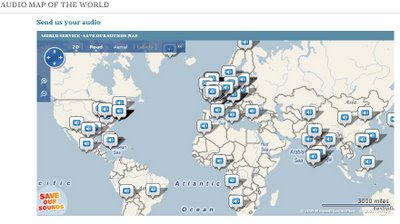
    "BBC wants you to help build an interactive map of the world. So get involved and send in recordings of sounds from where you live. Listen to the sounds of the world - and then send us your audio."


    BBC World Audio Map - Save Our Sounds
    The Map has already a good few audio snippets you can listen to directly from the map.

    "Save Our Sounds, but we need your help to create an audio map of the world. We’re especially keen to preserve endangered sounds for future generations.

    You can get involved by sending us sounds from where you live, and then listen your way around the world with our interactive map."

    View the BBC Audio Map

    http://www.bbc.co.uk/worldservice/specialreports/saveoursounds/index.shtml


    Source: And more 'BBC' Bing Mashups
    http://www.bing.com/community/blogs/maps/archive/2009/06/23/bbc-goes-big-on-bing-maps.aspx

    Labels: , , , , ,

    05 June 2009

    Bing Maps Silverlight - World Tour

    Bing Maps Silverlight - World Tour

    Bing Maps Silverlight World Tour

    "Microsoft will announce the latest imagery updates to its Bing Maps platform, which for the first time, can all be viewed using the brand new ‘Bing Maps World Tour’ application. Just about every month, Microsoft adds tens of terabytes of new content to Bing Maps, bringing new locations to life and reinvigorating pre-existing areas with fresh, high resolution imagery. Now, thanks to Silverlight and Windows Azure technology"

    To see a live example of this (silverlight plug-in required)
    http://bingmapsupdates.cloudapp.net/

    YouTube Video of it in action.


    Source with thanks to:
    Guy McGerr
    www.webershandwick.co.uk

    Labels: , , , ,

    03 June 2009

    Bing Maps for Mobile (with directions)
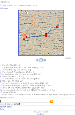
    Bing Maps for Mobile (with directions)

    related update: Just released!
    Bing Maps 3D -
    http://tinyurl.com/Bing-Maps-3D
    (though it is/was the same as Virtual Earth plugin just renamed)
    source:
    http://www.microsoftwindowsos.com/bing-maps-3d-has-been-released


    Bing Maps for Mobile (Cell) Phone is now available with Driving Directions and Walking Directions.

    Bing Maps for Mobile Devices
    Clean and Simple -Very fast response for Mobile devices.


    There seems to be a neat function that it takes traffic information and applies it to the outcome or at least a warning of possible delays.

    It is possible to test this function on a normal web browser

    Other features are available (weather, local information etc.) from http://m.bing.com/

    here is the link

    http://tinyurl.com/BingMapsMobile

    Labels: , , , , , ,