->

30 November 2007

GeoWizards 9.7 for ArcGIS

GeoWizards 9.7 for ArcGIS
One of the best all round third party extensions you can get for ArcGIS - lots of functionality is *Free*

"A collection of powerful data manipulation, topology and surface functions for ArcGIS "
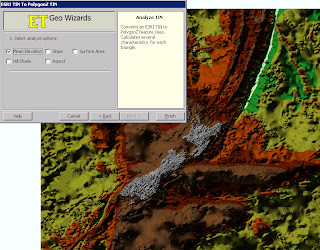
GeoWizards 9.7 TIN to Features Elevation

New functions are:

Map To Google Earth
Feature Class to Google Earth
Import from Google Earth
Polygon Characteristics
Perpendiculars from points to polylines
ESRI TIN To PolygonZ
Shape To ShapeZ
Point To Multipoint
Disperse Points
Random Points On Polylines
Random Points In Polygons
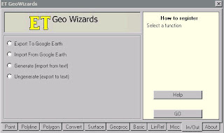
GeoWizards 9.7 Import or Export to Google Earth (KML)

* New method (number of vertices) included in the Split Polyline function
* Create Centerlines and Aggregate Polygons functions added to the version for ArcGIS 8.x.
* Scripting and toolbox implementation of the Ungenerate function added.
* Two new options added to the Features To Bounding Rectangles function.

Improved is:
* Improved performance and ability to handle large datasets. Functions affected:
o Build TIN
o Build Thiessen
o Aggregate Polygons
o Create Centerlines
* The Clean Dangles function allows user defined Fuzzy/Cluster tolerance to be assigned - better user control over the function.
* Improved error reporting
* **Several Functions improved to handle datasets with Z or M values. In the previous versions the input Z(M) values were dropped .
Functions affected:
o Clean Polygons
o Clean Polylines
o Erase
o Batch Erase
o Clean Dangling Nodes
o Clip
o Batch Clip
o Advanced Merge
o Symmetric Difference
o Merge Layers
o Split By Location

Bugs fixed:

Point Intersection function produces incorrect results if a polygon dataset that have polygons with holes is used.

A licensing problem in the Scripting and ToolBox implementations in ArcGIS 9.0.

***Inability of some of the functions to handle correctly datasets containing true Arcs. Functions affected:
Build Polygons
Clean Polygons

***Some of the tools of the ToolBox implementation produce an Windows error if used within a script run from the command prompt. The results are derived, but the tool breaks up the script. Tools affected:
o Clean Polygons
o Clean Polylines
o Clean Dangling Nodes
o Clip
o Erase
o Advanced Merge
o Symmetric Difference
o Thin Points
o Aggregate
o Interpolate Contours
o Create Centerlines
* Point Angle And Position function fails in some cases when the source paint dataset is a PGDB feature class
***Several functions fail if the output is File Geodatabase:
o Points To Polylines
o Points To PolylinesZM
o Points To PointsZM
o Points To Polygons
o Points To PolygonsZM
o Batch Drop Z(M)
o Batch Clip
o Batch Erase

** Only the version for ArcGIS 9.0 and above
*** Only the version for ArcGIS 9.2

One of the best and most useful functions that this extension has is 'Create Shapefile' inside ArcMap to create a new point, line or polygon.

For more information and to download this extension go to:
http://www.ian-ko.com/

Labels: , , , ,

28 November 2007

Google Maps Mobile 'My Location' (Beta)

Google Maps Mobile 'My Location'
(with or without GPS - uses mobile/cell triangulation)

"See your location on the map, with or without GPS. Save time and tedious keystrokes finding where you are, what's around you, and how to get there. Watch the video on the right to see how it works."

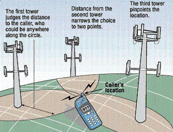
 Mobile Cell Triangulation

Roughly how it works....

Here is the video guide.


"Why the uncertainty? The My Location feature takes information broadcast from mobile towers near you to approximate your current location on the map - it's not GPS, but it comes pretty close (approximately 1000m close, on average). We're still in beta, but we're excited to launch this feature and are constantly working to improve our coverage and accuracy.

The My Location feature is available for most web-enabled mobile phones, including Java, BlackBerry, Windows Mobile, and Nokia/Symbian devices."


Yes, it can be disabled.

Source: http://searchengineland.com/071128-110000.php

Labels: , , , ,

Google Maps Terrain

Update
Google Maps API users will be pleased to know the Terrain Layer will be available.
Sneek Peek

http://gmaps-samples.googlecode.com/svn/trunk/terrain/terrain_maptypecontrol.html
But wait for the official blog post...
http://mapperz.googlepages.com/Google_Terrain.html
(ok maybe not wait)


Google Maps Terrain
New!
Google Maps Terrain - The Alps
A nice new visual layer called 'Terrain' a physical representation of the ground and elevation
Google Maps Terrain - New York
Large U.S. Cities have Oblique 2.5D Buildings in Terrain Mode.
But where is the Hybrid Mode gone?
Google incorporated the hybrid feature into the satellite mode. Just click Satellite and then you’ll see the checkbox appear which says “show labels.” If the box is checked roads/streets will be labeled just as Hybrid mode.

Labels: , , , , ,

27 November 2007

Tabula Peutingeriana Map

Tabula Peutingeriana Map (one of the first find your nearest maps?)

Visitors walk on a carpet depicting the "Tabula Peutingeriana" as they look at original fragments of the ancient roadmap of the Roman Empire dating back to the late 12th or early 13th century in the national library in Vienna November 26, 2007

"The parchment scroll, nearly 7 metres (yards) long, could only be displayed briefly because too much light would damage it, before it was returned to storage at Austria's National Library, where it has been since 1738"

Tabula Peutingeriana Map
Image Source: Reuters

"It's a bit like when you look at a map of the Vienna underground system, it's not accurate but it gives you a good idea of how to get around"
Andreas Fingernagel of the Austrian National Library

Sources:
Reuters
BBC News

Labels: , , , , , ,

22 November 2007

Nokia Sports Tracker Beta Map

Nokia Sports Tracker Beta Map

Nokia Sports Tracker Beta

http://sportstracker.nokia.com/nts/main/index.do

Sports Tracker version 1.63 is available from this site (login required)

  • Integrated with Google Maps: "satellite" or "map" view.
  • Store and display your activities online
  • View detailed data such as speed, distance etc
  • Upload geotagged photographs of your activities
  • Live Sharing of activities
  • Free (no subscription)
Download for Nokia Phones
http://sportstracker.nokia.com/nts/download.jsp
But still not integrated with Nokia Maps!
(now that would be very useful)

for more detailed information on the sports tracker
http://www.e-series.org/archives/450

still not sure why it only uploads gpx files and not kml files

What tools do I need to use the Nokia Sports Tracker Online service?

For viewing the stuff on Nokia Sports Tracker Online you need a web browser.

Mozilla Firefox is recommended.

http://sportstracker.nokia.com/nts/faq.jsp


Labels: , , , , , , ,

20 November 2007

Google Reverse Geocoder Update

Google Reverse Geocoder Update New! v1.0.2

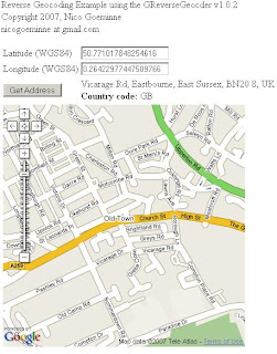
Reverse Geocoding is the inverse relationship where each geographical coordinate is mapped to the nearest known address. Currently this feature is not directly supported by the Google Map API. But can be done by Nico's Reverse Geocoder for Google Maps API using Google's Directions functionality.

Based on the Original Post by Mapperz


Nico has been keen to add some more useful functionality to the Reverse Geocoder.

Reverse Geocoding Updated - New v1.0.2

Pan and Zoom click your location and the address and country code is shown.

What is New?
  • all supported countries
  • house number support (experimental)
Test Country support here
http://nicogoeminne.googlepages.com/full2.html

Available Counties:

CountryGClientGeocoderGDirectionsGReverseGeocoder
Austria x x p
Australia x x p
Belgium x x x
Brazil x x x
Canada x x p
The Czech Republic x x p
Denmark x x p
Finland x x p
France x x x
Germany x x x
Hong Kong x n n
Hungary x x p
India x n n
Ireland x x p
Italy x x x
Japan x n n
Luxembourg x x x
The Netherlands x x x
New Zealand x x x
Norway x x p
Poland x x p
Portugal x x p
Singapore x x p
Spain x x p
Sweden x x p
Switzerland x x p
Taiwan x n n
Thailand x x p
United Kingdom x x x
United States x x x

(x=available, n=not available, p=probably available but not tested)

Experimental House Number Support

Since v1.0.2. Once the Reverse geocoder is set up experimental house number support is enabled by calling the setExperimentalHouseNumber method as shown in the example.

reversegeocoder.setExperimentalHouseNumber(true);

Important note:
THIS FEATURE IS EXPERIMENTAL AND USES MULTIPLE
GClientGeocoder AND GDirections
REQUESTS WHICH COULD EXCESS THE GOOGLE REQUEST LIMITS.
That's exactly why it is disabled (uncommented) in the full example.
Use it on own risk.

Labels: , , , , , , , ,

19 November 2007

ESRI ArcGIS 9.2 - Tips and Tricks (Updated)

updated 16/11/2007
So ArcGIS 9.2 and with Service Pack 4 installed.
and still going slow?

Here is Mapperz ArcGIS Tips and Tricks to get you more productive without the caffeine.

Okay Please note not supported by Mapperz but these methods 'help' ArcGIS run faster and give extra memory allocation.

You will have to log on your system as an administrator to make these tweaks

Before ArcGIS the Operating System should be tuned for ArcGIS.

Based on Windows XP Pro Starting Point

Make XP Run for ARCGIS better

RAM, Virtual Memory, Pagefile and all that stuff
http://support.microsoft.com/kb/555223

How to set performance options in Windows XP
http://support.microsoft.com/kb/308417/

Edit the Boot.ini My Computer>Properties>Advanced>Start Up and Recovery>Edit (Boot.ini)

/MAXRAM

If using an AMD Processor switch off 'Data Execution Protection'
* A common problem this is left on and some ArcGIS code is detected as 'bad' code therefore arcgis install will roll back
and unistall.

NOEXECUTE=ALWAYSOFF


http://www.microsoft.com/technet/sysinternals/
information/bootini.mspx

How to configure SQL Server to use more than 2 GB of physical memory
http://support.microsoft.com/kb/274750
SQL Server 2GB

Increases the size of the user process address space from 2 GB to 3 GB
(and therefore reduces the size of system space from 2 GB to 1 GB).
Giving virtual-memory
intensive applications such as database servers a larger address space can improve their performance

/3GB

so boot.ini looks like this

[boot loader]
timeout=30
default=multi(0)disk(0)rdisk(0)partition(2)\WINDOWS
[operating systems]
multi(0)disk(0)rdisk(0)partition(2)\WINDOWS="Microsoft Windows XP Professional" /noexecute=AlwaysOff /MAXMEM /3GB /fastdetect

Now install ArcGIS 9.2 with the service pack 4
(you can make these changes after you have installed ArcGIS)

Got Floating licenses?
If so and you want to share Arc/Info licenses but allow the user to use ArcGIS you can add ArcView single license to the Desktop Administrator.

It is very simple to do this. Just add the ArcView DVD to the DVD and got to install it. It will detect that ArcInfo is already installed and adds a component into desktop administrator.
Arc Desktop 9.2 Administrator

ArcGIS Improvements

C:\arcgis\Utilities\AdvancedArcMapSettings.exe
Change
Jet Engine to 120000 from the default 9600
This allows more records to be written from memory to shapefile/geodatabase


Printing Large Plots? (over 40 inches)
http://support.esri.com/index.cfm?fa=knowledgebase.
techarticles.articleShow&d=30516

Resizing from 42 inches to 60 inches
arcview\arcpress\etc directory
arcexe9x\etc\device1.dat file
To make the RTL drivers print wider than 36":
in the four lines beginning with 'RTL', change '10350' to '12150' to print 42" wide
'14550' to print 50" wide
and '17550' to print 60" wide

Finally got a PC with or over 2GB of RAM?
make the page file size bigger

Using RegEdit (Only do this if you know what it is)

HKEY_LOCAL_MACHINE\System\CurrentControlSet\Control\
SessionManager\MemoryManagement

c:\pagefile1\pagefile.sys 3000 4000
c:\pagefile2\pagefile.sys 3000 4000
c:\pagefile3\Pagefile.sys 3000 4000

Source:
Overcoming the 4,095 MB paging file size limit in Windows
http://support.microsoft.com/kb/237740


and a last tip is those pesky *.aux files that ArcGIS creates for raster display - delete them by a dos batch file and apply it to your start up (aux_delete.bat)

ECHO OFF
ECHO .
ECHO .
ECHO .
ECHO ***************************************
ECHO * *
ECHO * DELETING TEMPORARY AUX FILES... *
ECHO * *
ECHO ***************************************
ECHO .
ECHO .
ECHO ON
cd c:\data
cd d:\data
del *.aux /s
exit

*change c:\data & cd d:\data to your own raster locations

that should make ArcGIS go a little faster.

This post is a result of user experience and Microsoft Pages and ESRI Support.
Use at your own risk.

Use the ESRI Web Based Help - this is more up-to-date than the Installed version.

Labels: , , , , , , ,

17 November 2007

Google UK Carbon Footprint Project Map

Google UK Carbon Footprint Project Map

Google UK - The Carbon Footprint Project Map

Google Aims
"Google aims to help people find information that matters to them quickly and easily. Through the UK Carbon Footprint Project we make information on calculating and reducing your carbon footprint, as well as information on climate change in the UK, easily accessible to everyone"

The project enables you to calculate your carbon footprint, choose personalised carbon-reducing actions and compare your footprint and actions to those of others around the country by placing yourself on the Google UK Carbon Footprint Map.

The Map

Use the Google UK Carbon Footprint Map to find resources and facts about the UK’s carbon emissions and climate change. They have worked with partners to create special layers for the map which will show information such as recycling rates of local councils, heat map images of famous buildings, where your nearest recycling points are and predicted future weather under different carbon emission scenarios.

Google UK - The Carbon Footprint Project Map - Waste

The map also shows everyone taking part across the country, making it easy to see how individual actions add up to make a difference. The constantly updated project statistics will show how many people are taking part and the total carbon saved. To show the real impact of what is achieved, the carbon saving will be compared to carbon emissions of places across the country, effectively "wiping out" the carbon emissions of towns and cities.

Questions your be asked on your impact.

For Schools (Carbon Footprint Projects)

If everyone does there bit - it might just work.

Labels: , , , ,

16 November 2007

ArcGIS 9.2 Service Pack 4 Soon

ArcGIS 9.2 Service Pack 4 Out Now

So here is the ESRI Service Pack 4 Link
http://support.esri.com/index.cfm?fa=downloads.patchesServicePacks
.viewPatch&PID=17&MetaID=1351

176mb for the ArcGIS Desktop SP4 installer
379mb for the ArcGIS Desktop Help

Nothing new but lots of bug fixes....

Mapperz top picks...

  • NIM002728 - GeoTIFF files created with the ArcMap Export Map function should contain spatial reference information in addition to the currently encoded position and transform.
  • NIM007791 - Append Annotation tool in ArcToolbox creates duplicates of all fields for each annotation feature class being appended.
  • NIM007843 - Text symbol halos often fail to draw correctly, or they drop out.
  • NIM008760 - File geodatabase raster catalogs with managed imagery crash ArcGIS Engine applications.
  • NIM009820 - Graphic elements added using the Insert Picture command may have some pixels turn black when the MXD is saved with elements in "Save picture as part of document" mode. Parts of the picture may also turn black during export to PDF or other vector graphics formats.
  • NIM010025 - Closing the map when multiple editors are editing a version concurrently does not save edits when requested.
  • NIM011119 - Browsing for PMF (ArcPublisher) files will no longer cause the computer to freeze.
  • NIM011379 - When switching from the Maplex labeling engine to the standard ESRI labeling engine, the View Unplaced Labels function stops working for the standard labeling engine, and any previously displayed unplaced labels are removed.
  • NIM011521 - The ExportCAD function now creates a new PRJ file if overwriting an existing CAD file that already has a PRJ file, along with the CAD file.
If you have a spare 15-20 minutes you can read the full list of bug fixes.
http://support.esri.com/index.cfm?fa=downloads.patchesServicePacks
.viewPatch&PID=17&MetaID=1350

ArcGIS 9.3 (with Postgres support) out Early Next Year 2008

here is a good article on ArcGIS 9.3 new features (pending after beta)
http://www.directionsmag.com/article.php?article_id=2494&trv=1

Look for to this 'Geoprocessing' where users can share their geoprocessing models

One is described here 'Regression Analysis'
http://blogs.esri.com/Info/blogs/ucblog/archive/
2007/06/20/eoprocessing-advancements
-provide-greater-scientific-analysis.aspx

Labels: , , , ,

15 November 2007

Google Directions Tweak

Google Directions Tweak - Non Stop

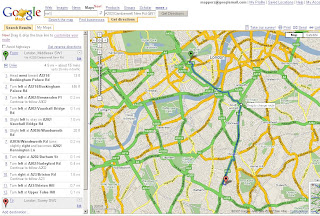
The Google Directions with the draggable route (auto-recalculates your route) has had a tweak.
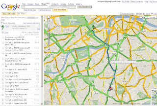
When you now drag the route and release at a location there is no longer an intermediate stop marker added. This makes a small but very good improvement on the results of the directions.

here is a quick example sw1 to sw2 and re-routed
Google Maps Drag Directions Update Tweak

Google Maps Drag Directions Update Tweak - Non Stop
see the route, now excludes a stop so directions are more accurate.

Simple but very useful.

Official blog post on this
http://google-latlong.blogspot.com/2007/11/viva-la-via.html

Labels: , , , ,

14 November 2007

New Draggable Geograph Map (Beta)

New Draggable Geograph Map

Geograph Map just got easier to use...

Geograph Draggable Map Beta
New draggable maps using Ordnance Survey 1:50,000 mapping (Landranger series)
What is Geograph?
"The Geograph British Isles project aims to collect geographically representative photographs and information for every square kilometre of the UK and the Republic of Ireland, and you can be part of it."

Draggable Geograph Map of Great Britain (beta)

64% complete for the British Isles
http://www.geograph.org.uk/numbers.php

How is this done?
Servers “Jam” “Toast”, “Scone” and “Crumpet” (a good start to any day)
http://blog.dixo.net/2006/07/28/geograph-servers-coming-to-life/

This site uses an Educational Licence from the Ordnance Survey
"Great Britain 1:50 000 Scale Colour Raster Mapping © Crown copyright Ordnance Survey. All Rights Reserved. Educational licence 100045616."

How is the done?
"But basically it just (JUST!?) involved cutting up 12GB of raw tiff files from the
OS, into more manageable png chunks using imagemagick, and then on
demand but cached on disk it cut into png tiles. The overlay is also
generated in php, ondemand and cached with memcached. And of course it
using openlayers as the client library."
Barry Hunter (nearby.org.uk)

Mapperz thanks Barry for sharing his time and tweaks on this. Well done and keep up the good work.


Just a quick note to UK Teachers out there - the 16th November is the last date to get Free Ordnance Survey Maps (for 11 year olds)
http://freemaps.ordnancesurvey.co.uk/freemapsfor11yearolds/

Labels: , , , , , , ,

12 November 2007

Bird Flu Map - Hits UK Norfolk/Suffolk

Bird Flu - Hits UK Norfolk/Suffolk

"Further restrictions are being put in place in a wider area surrounding the infected premises near Diss as a precautionary measure.

In consultation with ornithologists and other experts, a wider Restricted Zone has been established in addition to the controls put in place earlier today; i.e. the 3 km Protection Zone and 10 km Surveillance Zone around the Infected Premises. The new Restricted Zone covers much of Norfolk and the whole of Suffolk.

This is still an early stage in the outbreak. The new Restricted Zone requires the isolation of poultry from wild birds. Movements within this zone can take place, but movements are not permitted out of the new zone at present. We expect to make available general licences for low risk movements out of the zone shortly.

No movements of poultry are permitted at present in the 3km and 10km zones around the Infected Premises.

These measures are a precaution while the results of further laboratory tests and investigations into the outbreak are awaited.

In addition, the national general licence permitting bird gatherings in England has been revoked, and bird shows and pigeon racing will not be permitted for the time being.

As further information becomes available, and in consultation with ornithological and other experts, the restrictions in place may be adjusted."

Advice from the Food Standards Agency remains that properly cooked poultry and poultry products, including eggs, are safe to eat

Based on the information from the Defra Website and BBC News

A Google Earth KML File can be created for overlay on Google Maps/Google Earth
3KM Restriction Zone
10KM Surveillance
(Subject to change)


View Larger Map

Labels: , , , , , , ,

09 November 2007

East Coast England Flood Map

East Coast England Flood Map

England Flood Map
Source: BBC News/Environment Agency/Science Media Centre


Floo
d warnings are in place in Norfolk and Suffolk in eastern England, as a tidal surge builds in the North Sea.


Why is this happening?

Tidal Surge Map
Source: BBC News/MetOffice
  • Prevailing SW winds carry depression to NW Scotland
  • "Mean" current forces surge to right of wind direction
  • If low also moves east, surge is forced southwards
  • Shallower seabed means surge elevations higher in southern parts of North Sea
  • Spring Tides
Full Story on the BBC News Website

Has this happen before?
Yes in 1953 but with out the technologies in weather and sea surges prediction caused widespread flooding.
http://www.bbc.co.uk/weather/features/understanding/1953_flood.shtml

Labels: , , , , ,