->

31 December 2007

Testing the N82 with Sports Tracker (Beta)

Testing the N82 with Sports Tracker (Beta)
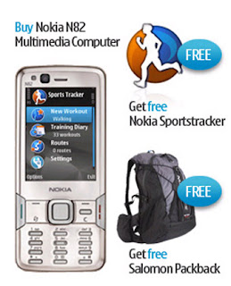
Nokia N82 with Adventure Pack

Mapperz goes testing....N82 Sports Tracker (Beta) and Nokia Maps (phone, sports tracker software and bag generously supplied by WOM World)
http://www.womworld.com/nseries/category/n82/

Not going to go into details of build quality, looks or if it makes phone calls. There are plenty of other sites doing this.
Gets Go!

Sports Tracker enables the user to log or track your progress, it displays a pace, speed, altitude etc.
Official Full Details
http://research.nokia.com/research/projects/SportsTracker/

Sport Tracker Beta Site
http://sportstracker.nokia.com/nts/main/index.do (login required to use the service Free)

Mapperz coverage of the Sport Tracker Beta (previous post)
http://mapperz.blogspot.com/2007/11/nokia-sports-tracker-beta-map.html

Integrated GPS
Get as quick fix with the assistance of:

BlueTooth GPS (not needed)
A-GPS on
Integrated GPS on
Network Based on

Access point
GPRS (check default as will use WAP which is more expensive)
nokia server for A-GPS
supl.nokia.com

WOM wanted Mapperz to test out.
"Testing the sports trackers ability to track journey routes, along with other info regarding altitude, distance etc would be really interesting!"

So here is a train journey...
N82 Sports Tracker Beta in Google Earth

A tracking issue or gps issue?

N82 Sports Tracker Beta GPS errors?
Think the issue here is that the GPS and lack of 'field of view' to the sky.
A 'wobble' in the tracking - due a high filter correction method as default?
here is an interesting article
http://wubbahed.com/2007/07/12/gps-quality-on-the-n95/
Highlights the GPS being 'hyper-active' (note this was from an N95 with firmware updates)
The N82 seems better than the N95 for 'gps filtering'

Maybe there is a call for the A-GPS to be active on startup with an option to disable it on tracking mode (unless within an urban area). This should create a smoother tracking line.

Improvements: that could make this the perfect mobile map device:
  • Nokia please add the Nokia maps (map data) to the sports tracker. Not the navigational functions just the base map. (Mapperz has done this via Nokia Feedback). This would improve the usefulness of the application beyond 'tracking'.
  • Automatic screen rotation option to switch it off. Walking briskly with it in hand for using it in Nokia Map mode was jumping into landscape mode.
  • Ghost Tracking - where a previous track can be overlaid, very useful to runners, walkers etc would like to do the same routes in part of their routine.=
  • Imperial/Decimal Mode but with the option of Meters in Height (UK distance in Miles but UK height in Meters)
Spot the difference between Sports Tracker and Nokia Maps
Noticed when in Nokia Maps - the 'tracking' would snap to roads running along next to the railway. But the Sport Tracker did not.
This is a small issue - there must be some sort of rank - Motorways more important than Rail or A Roads on the Vector Map Data.
Have noticed that when going over a bridge going over a motorway/primary route the cursor snaps the major road rather than the road your are on.

N82 v N95
Not an easy one but there are improvements in the N82 over the N95.
Start up is faster & less crashing when running multiple applications
Camera Flash at night is much better on the N82 by miles.
Battery life has improved on the N95 (even after firmware v20).
But the N82 battery seems to go further than the N95 by about 6 hours (general use).
Screen size is a little smaller than the N95 but in general not any less functional.
It's slightly cheaper

If you want go for an unlocked N82 for 2008.
Test a N82 (limited places left)
http://www.nseries.com/index.html?l=campaigns,n82,demand#l=campaigns,n82,demand

If buying it - its worth getting directly from here at £399 +£3.99 standard delivery.
(you get a free bag.)
http://shop.nokia.co.uk/nokia-uk/product.aspx?sku=3759722&section_id=530&culture=en-GB

Clincher - N82 with TomTom - in Car
The N82 is a better navigational device for getting around London against the TomTom
XL Europe. why?
TomTom data was out of date and 'drop out' from GPS mode in between high buildings.
N82 had up to date data and no drop out was noticed (A-GPS and cell based positioning was on)

Full Spec of the N82 in depth.
http://www.gadgetnutz.com/modules/news/article.php?storyid=00420

Yes you can make and receive phone calls to.

Thanks to WOM World for the chance to test the phone and sports tracker.
Labels: , , , , , ,

28 December 2007

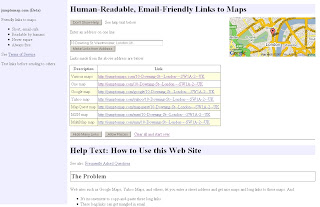
Jump to Map (Beta) - Human Readable Links

Jump to Map (Beta)

Jump to Map

Create Human Friendly links (urls) to maps.

  • Short, email-safe.
  • Readable by humans.
  • Never expire.
  • Always free.

Web sites such as Google Maps, Yahoo Maps, and others, let you enter a street address and create nice maps and long links to these maps.

* It's inconvenient to copy-and-paste these long links.
* These long links can get jumbled in email.
* These links seem to be in some odd computer language—they make no sense to the human reader.

Some web sites on the Internet will let you make a short link from a long one.
* You have to visit two different web sites.
* You still have to figure out how to copy-and-paste the long link.
* The short link still makes no sense to human readers.

Example
10 Downing St, Westminster, London
returns
10 Downing St, Westminster, London, US
but
10 Downing St, Westminster, London, UK
creates the correct location.
http://jumptomaps.com/10-Downing-St--London---SW1A-2--UK


http://jumptomap.com/

Labels: , , , , ,

27 December 2007

iPhone GPS

iPhone with GPS

  • better fix
  • better accuracy
iPhone LOCO GPS
iPhone with GPS Module


iPhone LOCO GPS dimensions
Loco GPS

Images courtesy of
http://partfoundry.com

More Information:
http://partfoundry.com/iphonegps.html


The GPS module will work on both the iPhone as well as the iPod touch

price
$89
£44.98

Labels: , , , ,

21 December 2007

Live Search Maps - Coverage Updated

Live Search Maps Coverage Updated

(Virtual Earth has updated 36.3 TB of data)
UK Coverage listed here

Liverpool Buildings in 3D Virtual Earth
Liverpool gets 3D Buildings

Aerial Imagery
Supplied by GetMapping UK:

* England\Wales (12.5 cm)
* Scotland (25 cm)

BIRD'S EYE AERIAL IMAGERY
Castleford, UK
Chester, UK
Crewe, UK
Darlington, UK
Dearne Valley Urban Area, UK
Harrogate/Knaresborough, UK
Hartlepool, UK
Leeds, UK (1 & 2)
London, UK (several AOIs here)
Macclesfield/Pretsbury, UK
Middlesborough, UK
Milton Keynes, UK
Newcastle, UK
Reading/Workingham, UK
Scarborough, UK
Scunthorpe, UK
York, UK (1 & 2)
*AOI = Area of Interest

3D City
* Liverpool, UK (43.04 sq. mi.)

For more Worldwide updates go to the Official Virtual Earth Blog.
http://virtualearth4gov.spaces.live.com/Blog/cns!369B39F890CE30C1!607.entry

Labels: , , , ,

20 December 2007

Yahoo Maps Re-route Directions

Yahoo Maps have made a change to the directions function. You can now re-route by dragging the original route (similar to google maps directions).

Yahoo Maps Drag and Drop Routes - before

Yahoo Maps Drag and Drop Routes - after
Try it at
http://maps.yahoo.co.uk/ (UK Centred)
or
http://maps.yahoo.com/ (US Centered)

Labels: , , , ,

19 December 2007

Ordnance Survey - OpenSpace API ( now with Demo)

19/12/2007
update: Found a Demo Page with using OpenSpace API

OpenSpace Map Image for Illustration
Image is for illustration only.

On closer inspection there is a lot of content which has been removed at the larger scales.
Live Demo
http://www.maptasm.com/


Ordnance Survey - OpenSpace API
(Alpha)

Ordnance Survey OpenSpace Logo

"Got a great idea? Make it work with the best mapping in the world."
(well Great Britain anyways)

"OS OpenSpace is a free Ordnance Survey service that allows you to embed Ordnance Survey maps covering England, Scotland and Wales in your web applications using our Javascript® application programming interface (API)."

Some Functionality :

The OS OpenSpace API and all the data provided is in British National Grid (ESPG 27700).
The API also provides the ability to covert between National Grid and latitude and longitude (ESPG 4326) and vice versa.


OS OpenSpace allows your API key to access up to 30 000 tiles of data and up to 1 000 place name look-ups per day for free

Can you add Ads to the API?
No, please see the OS OpenSpace Developer Agreement (there can be no form of financial gain).
FaceBook, MySpace apps?
No, The application you build cannot result in any financial gain to you (the developer of the application), the user or any other party; please see the OS OpenSpace Developer Agreement .


Note: Any Content you create using the Open Space API - Will not be yours, as it is 'dervived' from Ordance Survey Products.

the ownership and licensing of the copyright and other intellectual property rights in:

* any data supplied to you by us; and
* any data created by you.

Primarily, you cannot use any data you create for any commercial purpose.

No 1:25,000 (Explorer range) or 1:10,000 Rasters


More Information:
The Guardian
http://www.guardian.co.uk/technology/2007/dec/13/freeourdata.software

Ed Parson's (Ex CTO Ordnance Survey) briefly mentions it too
http://www.edparsons.com/


OS OpenSpace is currently running as a closed alpha test service.

OS OpenSpace Developer Agreement is 16 Pages long.

http://openspace.ordnancesurvey.co.uk/openspace/index.html


It's a good step forward, but very restrictive in use.
Hopefully can be developed for Educational and Charity Institutions

At least Microsoft haven't bought them yet.

Stefan Geens writes an excellent roundup of the implications of this API. Removing ads from his site could only run the OpenSpace API on the Ogle Earth site for 12 hours a day due to the amount of traffic it generates.
http://www.ogleearth.com/2007/12/ordnance_survey.html
(But I think he will stick to his current formula with ads.)

Labels: , , , , ,

18 December 2007

Defra UK Airport Noise Maps

Defra UK Airport Noise Maps Available


"In 1996 the European Commission issued a Green Paper in which it was stated that an estimated 20% of the EU citizens were exposed to noise levels that scientists and health experts considered to be unacceptable, at which most people become annoyed, sleep is disturbed and health may be at risk."

UK Airports Noise Maps from Defra
All available from
http://www.defra.gov.uk/environment/noise/ambient.htm#aviation
(1 to 4mb PDF's with Ordnance Survey 1:50,000 Rasters included, Arcview 3.2 was use - north arrow and scale bar giveaway there.)

Airports included:
Birmingham International Airport
Blackpool Squire’s Gate Airport
Bournemouth Airport
Bristol Lulsgate Airport
Coventry Airport
Leeds Bradford Airport
Liverpool John Lennon Airport
London City Airport
London Gatwick Airport
London Heathrow Airport
London Luton Airport
London Stansted Airport
Manchester International Airport
Newcastle International Airport
Nottingham East Midlands Airport
Shoreham Airport
Southampton Eastleigh Airport
Southend Airport

Glossary to help understand the maps

Decibel (dB)
The decibel (dB) is a logarithmic unit of measurement that expresses the magnitude of a physical quantity relative to a specified or implied reference level. Its logarithmic nature allows very large or very small ratios to be represented by a convenient number. Being a ratio, it is a dimensionless unit. Decibels are used for a wide variety of measurements including acoustics, and for audible sound A-weighted decibels (dBA) are commonly used.

dB(A)
A unit of sound pressure level, adjusted in accordance with the A weighting scale, which takes into account the increased sensitivity of the human ear at some frequencies

LAeq,T
The notional A-weighted equivalent continuous sound level which, if it occurred over the same time period, would give the same noise level as the actual varying sound level. The T denotes the time period over which the average is taken, for example LAeq,8h is the equivalent continuous noise level over a 8 hour period.

Lday
The A-weighted average sound level over the 12 hour day period of 0700 – 1900 hours.

Levening
The A-weighted average sound level over the 4 hour evening period of 1900 – 2300 hours.

Lnight
The A-weighted average sound level over the 8 hour night period of 2300 – 0700 hours.

Lden
The day, evening, night level, Lden is a logarithmic composite of the Lday, Levening, and Lnight levels but with 5 dB(A) being added to the Levening value and 10 dB(A) being added to the Lnight value

LAeq,16h
The A-weighted average sound level over the 16 hour period of 0700 - 2300

Noise Bands
Areas with similar noise exposure in 5 dB(A) ranges according to the key shown with the maps

Noise Contours
Lines showing the locations with the same noise exposure according to the key shown with the maps.

Labels: , , , , , ,

14 December 2007

Google Maps API - See the Sky, Moon and Mars

Google Maps API - have released Sky, Moon and Mars tiles in Version 2.95 of the API.

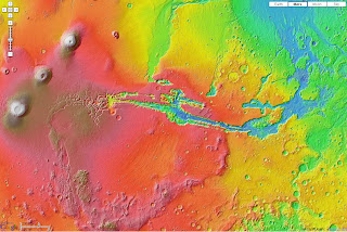
Google Maps API Mars Elevation Mode
Mars Elevation Tiles

This means you can now call up the tiles that Google Maps Moon/Mars and Google Earth Sky mode use.

Google Maps API Mars Mode
Mars there is an Infrared option too.

Google Maps API Sky Mode
It's dark out there!

Google Maps API Moon Mode
no cheese but good detail.

The original page
http://econym.googlepages.com/example_moon.htm

one bug found by Mike Williams [Google Maps API Guru]
http://econym.googlepages.com/bug_moon.htm
polylines disappears on switching modes
[this bug is already reported]

Mapperz version soon followed - as the curiosity got to them.

http://mapperz.googlepages.com/Google_SKY_MOON_MARS_Official_API.htm
l

More info:
http://groups.google.com/group/Google-Maps-API/browse_thread/thread/9da5d9f4d8dae310#

Official Blog Post
http://googlemapsapi.blogspot.com/2007/12/maps-from-another-world.html
Official Examples
http://gmaps-samples.googlecode.com/svn/trunk/planetary/planetary_maptypes.html

Labels: , , , , ,

12 December 2007

Microsoft Windows Update Kills ArcGIS Help

Microsoft Windows Update Kills ArcGIS Help

"ESRI® announces the ArcGIS 9.2 Desktop Help Search Patch. This patch solves an issue where the search tab in ArcGIS Desktop help becomes inoperable. We recommend all ArcGIS Desktop 9.2 users download and install this patch at their earliest convenience to ensure the highest quality experience when working with ArcGIS Desktop 9.2"

BBC 's Little Britain - Computer Says No!

    NIM013534 - AnswerWorks search in ArcGIS Desktop Help will stop functioning after a Microsoft Windows Update.

    Description

    The ArcGIS Desktop help uses a 3rd party search engine called AnswerWorks. Microsoft has released a security update to Internet Explorer affecting the Desktop help search to become inoperable. This patch resolves the issue of the search engine being non functional by updating the 3rd party search engine.


NOTE:
ArcGIS Desktop 9.2 Service Pack 4 must be installed before you can install this Patch.
If you have installed client setups from a shared Network Administrative ArcGIS Desktop setup, this Patch must be applied to all client installations.

Download the Patch
http://support.esri.com/index.cfm?fa=downloads.patchesServicePacks.viewPatch&PID=43&MetaID=1357

Labels: , , , , ,

06 December 2007

Géoportail 3D (Beta)

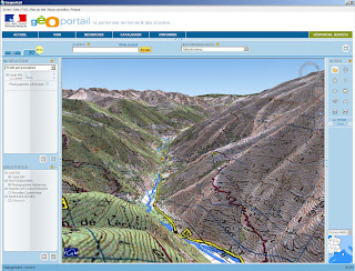
Géoportail 3D (Beta)

Géoportail in 3D
Clear maps draped in 3D

New Features:
  • Géoportail also takes into account the calculation of distances on the floor. Not as the crow flies.
  • Buildings in 3D on GeoPortal
  • Visualization of Land Parcels 3D
  • L'Institut National de l'Audiovisuel (INA) Videos (10000+)
English Translation of
http://www.renalid.com/2007/12/06/lancement-officiel-de-geoportail-3d/
(more screen shots and information here)

Windows Only (plug-in required)
GeoPortal 3D is only available on Windows by installing the latest version of TerraExplorer from Skyline Software


A quick play... in 3D mode.

Mapperz

Labels: , , , , , ,

05 December 2007

Yell Maps - New Features

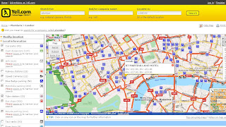
Yell Maps - New Features

Yell Maps - New Features

MultiMap Based Mapping
Microsoft Virtual Earth Birds Eye View Mode
Points of Interest (POI)
  • Car parks
  • Cash dispensers
  • WiFi Access
  • Railway stations
  • Speed Cameras
  • Blue Badge parking
  • Motorbike parking
  • Public toilets
  • Tube stations
  • Bus stops (Includes Bus Routes for that location)
  • Traffic news
  • Bicycle parking
  • Taxi ranks
  • River taxis
Note: POI Features are available in the Birds Eye View - Helps visually to users and builds a mental picture for when they get there.

Yell New Maps Birdseye with POI Overlayed

Yell New Maps Birdseye POI East Oblique View

Where to find these maps
http://www.yell.com/ucs/HomePageAction.do
and search with the 'Show on Map' ticked.

Think this is the first type of cross Mapping as using Multimap for the base mapping - but then Microsoft Virtual Earth is being used in the Birds Eye View.

Yell have done a good update and this will be the best mapping they have had on there website.
Prediction - 2008 Hybird Mapping API. Though check Terms and Conditions on using different mapping applications together, some prohibit use with 'competitors' mapping solutions.
i.e. Yahoo Geocoder is only allowed to be used with Yahoo Maps.

Labels: , , , , , ,

03 December 2007

thelondonpaper knowledge map

thelondonpaper knowledge map

"News International's free daily newspaper, has launched an interactive map of London with daily listings of theatre, comedy and art shows, as well as live music and nightclub events."

thelondonpaper map
up to date information overlayed Google Maps (including tube lines)
select 'when' [bottom right in the legend] and all the information updates in front of you.

Simple, Clean and Fast - the way maps should deliver information to the end user.

http://knowledge.thelondonpaper.com/

map found via http://www.brandrepublic.com

Labels: , , , , , ,