->

12 February 2009

Google Map Maker Tiles come to the API

Google Map Maker Tiles come to the API

Update:
One of the best areas of difference is in Sri Lanka
Here is the differences in Colombo


Google Maps Normal Tiles limited in content.
This shows the power of user contributed content.

http://mapperz.googlepages.com/mapmaker_api_sri_lanka.html
(Warning this example is in the latest *experimental* version of the api v146b and GLog is always displayed)

Google Map Maker gives users the power to add, edit and amend data in Google Maps.
This has been running for awhile, but as yet it has not been used by Google in the Main Google Maps Site.

A first. The Google Maps API has had the option of (G_MAPMAKER_NORMAL_MAP);
for a while but this has not been enabled, until today.Normal Google Map Tiles
Here is one Country in Google Maps with very little data coverage. Iceland.

But now with the API you can switch on the User Made Tiles from Google Map Maker.

Google Map Maker Tiles - Available
Not much more detail , but it is better than the normal tiles from Google Maps.
Note:Copyright is Google only. (Coastline TeleAtlas still?)

There are a number of Countries and this is one example, so check the list and see if the country your are interested has more content than the original Google Map Tiles.

You can view the example here:
http://mapperz.googlepages.com/mapmaker_api_iceland.html


Mapperz would like to thank Mike Williams for the tip off .
http://groups.google.com/group/Google-Maps-API/browse_thread/thread/4d44eed7fca98d35?hl=en#


Full list of Countries in Google Map Maker
* Algeria
* American Samoa
* Angola
* Anguilla
* Antigua and Barbuda
* Argentina
* Armenia
* Aruba
* Azerbaijan
* Bahamas
* Bahrain
* Bangladesh
* Barbados
* Belize
* Benin
* Bermuda
* Bhutan
* Bolivia
* Botswana
* British Indian Ocean Territory
* British Virgin Islands
* Burkina Faso
* Burundi
* Côte d'Ivoire (Ivory Coast)
* Cambodia
* Cameroon
* Cape Verde
* Cayman Islands
* Central African Republic
* Chad
* Chile
* Christmas Island
* Cocos Islands
* Colombia
* Comoros
* Congo
* Cook Islands
* Costa Rica
* Cuba
* Cyprus
* Democratic Republic of Congo
* Djibouti
* Dominica
* Dominican Republic
* Ecuador
* El Salvador
* Equatorial Guinea
* Eritrea
* Ethiopia
* Falkland Islands
* Faroe Islands
* Fiji
* French Guiana
* French Polynesia
* French Southern and Antarctic Lands
* Gabon
* Gambia
* Ghana
* Greenland
* Grenada
* Guadeloupe
* Guam
* Guatemala
* Guinea
* Guinea-Bissau
* Guyana
* Haiti
* Heard Island and McDonald Islands
* Honduras
* Iceland
* India
* Iran
* Jamaica
* Jordan
* Kazakhstan
* Kenya
* Kiribati
* Kuwait
* Kyrgyztan
* Laos
* Lebanon
* Lesotho
* Liberia
* Libya
* Madagascar
* Malawi
* Maldives
* Mali
* Malta
* Marshall Islands
* Martinique
* Mauritania
* Mauritius
* Mayotte
* Micronesia
* Midway Islands
* Mongolia
* Montserrat
* Morocco
* Mozambique
* Myanmar
* Namibia
* Nauru
* Nepal
* Netherlands Antilles
* New Caledonia
* Nicaragua
* Niger
* Nigeria
* Niue
* Norfolk Island
* Northern Mariana Islands
* Oman
* Pakistan
* Palau
* Panama
* Papua New Guinea
* Paraguay
* Peru
* Philippines
* Pitcairn Islands
* Qatar
* Reunion
* Rwanda
* Saint Helena
* Saint Kitts and Nevis
* Saint Lucia
* Saint Vincent and the Grenadines
* Samoa
* São Tomé and Príncipe
* Senegal
* Seychelles
* Sierra Leone
* Solomon Islands
* Somalia
* South Georgia and the South Sandwich Islands
* Sri Lanka
* Sudan
* Suriname
* Svalbard and Jan Mayen
* Swaziland
* Syria
* Tajikistan
* Tanzania
* Timor-Leste
* Togo
* Tokelau
* Tonga
* Trinidad and Tobago
* Tunisia
* Turkmenistan
* Turks and Caicos Islands
* Tuvalu
* Uganda
* Uruguay
* Uzbekistan
* Vanuatu
* Venezuela
* Vietnam
* Wallis and Futuna
* Western Sahara
* Yemen
* Zambia
* Zimbabwe


You can view the example here:
http://mapperz.googlepages.com/mapmaker_api_iceland.html

Labels: , , , ,

25 January 2009

Multimap - Ordnance Survey 1:25,000 Mapping Available

Multimap - Ordnance Survey 1:25,000 Mapping Available

update 26/01/2009 11.36am: from the forum link below- there has just been a reply from Multimap:

"We've worked with OS to get the data which features in the OS OpenSpace API (such as the 1:50k Landranger maps), also published in the Open API. Unfortunately, the 1:25k Explorer maps are not currently available through OpenSpace, so we can't currently make them available in a product such as the Open API. We can however make them available through our commercial API product (Multimap API)."
Julian Skeels, Senior Program, Manager Multimap

Come on Ordnance Survey free up your data! before your sold by the treasury...

“A STRING of state-owned household names including the Met Office, mapmaker Ordnance Survey and the Forestry Commission, are being prepared for sale by the government in the next two years to raise cash for the stretched public purse. ”
source:
James Ashton - The Times (November 23, 2008)


Finally 1:25,000 [Explorer] Mapping is available online for viewing and printing thanks to Multimap (Microsoft cash injection?).

This is the best overall mapping product Ordnance Survey produce for leisure tourism activities in Great Britain (England, Wales and Scotland).

View map of Malvern, Malvern Wells, Worcestershire, England, WR14 4 on Multimap.com
Get directions to or from Malvern, Malvern Wells, Worcestershire, England, WR14 4

[RSS Readers cannot show the embedded map so please visit http://mapperz.blogspot.com/ to see the Ordnance Survey 1:25,000 Mapping embedded in the blog - thanks]

Now users can see official public footpaths, more detailed contours, field boundaries etc.

This beats the only other current accessible service from Ordnance Survey 'Get a Map' service hands down.

Available Multimap Open API? No (currently - see comments & update)
Is this available in the MultiMap API? Yes
Possibly, with an experienced developer would be able create a workaround to switch the tiles when the map zoom scale is higher than 16. (this has been done! borderline with ToS)
Though it would be adviseable to wait and see if Multimap updated thier documentation on the Open API
*note the updated red notations (need to be dated) these have been like this for a while now.

Legend
A full legend of all the map symbols and representations
http://leisure.ordnancesurvey.co.uk/leisure/tscontent/products/os/explorer/symbols/25k_English_Legend_March08.pdf

Tile Source Structure.
http://mc2.tiles-cdn.multimap.com/ptiles/map/mi932/16/031313/100323/232.png
(does allow access to the raster png files but not recommended to do direct access to them as likely to be breaking multimap terms and conditions and ordnance survey copyright).

Source and a good question
http://forums.multimap.com/viewtopic.php?f=1&t=165

Official Blog Post
http://blog.multimap.com/2009/01/21/os-explorer-maps-on-multimapcom/

Labels: , , , , , ,

16 December 2008

Tiger Data 2008 Released

Tiger Data 2008 Released

update 20/01/2009
A new potentially good source is for Road Linework [editable in a GIS]
is the
National Transportation Atlas Database
http://www.bts.gov/publications/national_transportation_atlas_database/2008/
Now Available in ESRI Shapefile format

Tiger 2008 - US Census Bureau Logo
(Topologically Integrated Geographic Encoding and Referencing system)

The US Census Bureau has recently released the Tiger 2008 data to the public to download and use freely.

Shapefiles (most GIS Software can view them)
http://www2.census.gov/cgi-bin/shapefiles/national-files
Don't have a GIS?
A free Open Source GIS is Quantum GIS


Technical details are available

http://www.census.gov/geo/www/tiger/tgrshp2008/TGRSHP08.pdf

FTP available
ftp://ftp2.census.gov/geo/tiger/TIGER2008/

This updates the earlier post (April 2008)
http://mapperz.blogspot.com/2008/04/tiger-2007-data-release-esri-shapefile.html

The one thing the US Census website lacks is a geographical way of selecting the data.
County Finder at Maps Huge.com
Maps Huge helps users find neighbouring (neighboring) counties

Need to know an area in a visual way?
try
http://maps.huge.info/county.htm
or
http://maps.forum.nu/gm_main.html

Labels: , , , , ,

28 July 2008

State of the Map 2008 : Presentations - Open Street Map

State of the Map 2008's July 12th-13th Castletroy, Limerick has now got presentations available for people that could not attend the event.

These include:

OSM Cycle Map - See how much coverage there is now and the weekly process involved.
OpenStreetMap Cycle Map
http://www.gravitystorm.co.uk/osm/

OpenRouteService - The 'driving directions' using OSM data in German (see previous post)

The State of France - Highlighting activity and where needs to be mapped.

'So I have all this data'
- Showing the numerous OSM Style's (Mapnik, OSMRender, Cycle Map) and Green Maps (Sutton & Enfield examples).

The State of Italy - Looks into the success of OSM in the City of Milan from 2007 to 2008.

MapWarper - Showing some technical details of georefencing images. (Also see http://wrp.geothings.net/)

The Commerical Viability of OpenStreetMap
- How to make money and issues highlighted with OSM data - Make it easier to use!

FreeMapIndia 2008 (part1 & part 2) - A Photo Journal of Mapping and Talking OSM in India - Part 2 shows more technical mapping aspects.

OpenStreetMap vs The World
- "iTunes for your GPS" The Comparison to OSM and Google Maps for Haywards Heath. (mentioned here by Mapperz). OSM vs Reality and 'Wrong Names', 'Missing Roads' and Wrong Spellings of Street Names.

The State of Spain (Take 2) - The continuous task of data collection and the task that lies ahead. The mention of gvSIG GIS. Highlighting that GIS is important in managing OSM data.

London Mapping Marathon - Mapping shown at small scales - London looks complete, larger zoom levels show that there is a lot of roads un-named, incorrect junctions etc. (See older post)
But also shows the huge improvement of the past year.

Using Crowd Sourced Data in a Commercial Mapping API
- Investigates the Flickr, Geonames and Wikipedia methods. Conclusion is 'crowd sourced' data can work. Positive effects for little effort.

Look out for Video and more content coming to
http://wiki.openstreetmap.org/index.php/State_Of_The_Map_2008


Related Events:
Society of Cartographers
44th Annual Summer School, Aberdeen
1-4 September 2008
http://www.abdn.ac.uk/cartographers08/
"Presentations include ones on changing coastlines, 3D panoramas, kayak mapping, and cycle mapping – with presenters including Tom Patterson (US National Parks Service), Ed Parsons (Google), Paul Hardy (ESRI) and Professor Danny Dorling (University of Sheffield). There is a very full programme that includes many interesting topics, workshops and plenty of networking opportunities"
(thanks to SteveC via email)

Labels: , , , ,

16 April 2008

Google Earth 4.3 (Beta) Now Available

updated
New Keyboard Shortcuts
http://earth.google.com/intl/en_uk/userguide/v4/ug_keyboard.html
(dependant on language selected)


Google Earth 4.3 (Beta) is now available to download

Google_Earth 4.3 beta now available
Google earth 4.3 has new features...

Google Earth 4.3 beta better 3D Buildings
3D buildings look more true 3D and real. (Can now view in daylight/shadows/nighttime)


Google Earth StreeView

StreetView in Google Earth (See the 'Layers' >StreetView)
Click on the curved photographs zooms into a 'StreetView' Mode (Like in Google Maps)
See the Video for more details...


Video from the GEarthBlog http://www.gearthblog.com/

New Features

New navigational controls - New features enabling better ways to look around at 3D buildings - takes few seconds to get use to the new navigation but works well.

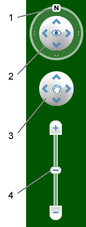
Google Earth navigation controls offer the same type of navigation action that you can achieve with mouse navigation. In addition, you can use the controls to zoom and swoop (perhaps for a perspective on terrain) or to rotate your view. The following diagram shows the controls and explains their functions.
New Navigation Controls

Click the north up button to reset the view so that north is at the top of the screen. Click and drag the ring to rotate your view.
Use the Look joystick to look around from a single vantage point, as if you were turning your head. Click an arrow to look in that direction or continue to press down on the mouse button and drag to change your view.
Use the Move joystick to move your position from one place to another. Click an arrow to move in that direction or continue to press down on the mouse button and drag to move.
Use the zoom slider to zoom in or out (+ to zoom in, - to zoom out). Double-click the icons at the end of the slider to reset the zoom all the way in or out. As you move closer to the ground, Google Earth swoops (tilts) to change your viewing angle to be parallel to the Earth's surface.
You can also use the keyboard to control navigation. See 3D Viewer Navigation in Keyboard Controls for more information.


  • Imagery Dates - You will now be able to easily see the dates when imagery was taken for most imagery (but, not all).

  • More 3D buildings, faster loading - Faster loading the 3D building models.

  • New photo-textured cities.

  • Day/Night Lighting - Real-time sunlight lighting option. Daylight/Time slider control of the sun's shadow position across the globe.

  • New Languages Support - even UK English!

Source:

http://earth.google.com/intl/en_uk/userguide/v4/

Download Google Earth 4.3

Labels: , , , , , ,

18 December 2007

Defra UK Airport Noise Maps

Defra UK Airport Noise Maps Available


"In 1996 the European Commission issued a Green Paper in which it was stated that an estimated 20% of the EU citizens were exposed to noise levels that scientists and health experts considered to be unacceptable, at which most people become annoyed, sleep is disturbed and health may be at risk."

UK Airports Noise Maps from Defra
All available from
http://www.defra.gov.uk/environment/noise/ambient.htm#aviation
(1 to 4mb PDF's with Ordnance Survey 1:50,000 Rasters included, Arcview 3.2 was use - north arrow and scale bar giveaway there.)

Airports included:
Birmingham International Airport
Blackpool Squire’s Gate Airport
Bournemouth Airport
Bristol Lulsgate Airport
Coventry Airport
Leeds Bradford Airport
Liverpool John Lennon Airport
London City Airport
London Gatwick Airport
London Heathrow Airport
London Luton Airport
London Stansted Airport
Manchester International Airport
Newcastle International Airport
Nottingham East Midlands Airport
Shoreham Airport
Southampton Eastleigh Airport
Southend Airport

Glossary to help understand the maps

Decibel (dB)
The decibel (dB) is a logarithmic unit of measurement that expresses the magnitude of a physical quantity relative to a specified or implied reference level. Its logarithmic nature allows very large or very small ratios to be represented by a convenient number. Being a ratio, it is a dimensionless unit. Decibels are used for a wide variety of measurements including acoustics, and for audible sound A-weighted decibels (dBA) are commonly used.

dB(A)
A unit of sound pressure level, adjusted in accordance with the A weighting scale, which takes into account the increased sensitivity of the human ear at some frequencies

LAeq,T
The notional A-weighted equivalent continuous sound level which, if it occurred over the same time period, would give the same noise level as the actual varying sound level. The T denotes the time period over which the average is taken, for example LAeq,8h is the equivalent continuous noise level over a 8 hour period.

Lday
The A-weighted average sound level over the 12 hour day period of 0700 – 1900 hours.

Levening
The A-weighted average sound level over the 4 hour evening period of 1900 – 2300 hours.

Lnight
The A-weighted average sound level over the 8 hour night period of 2300 – 0700 hours.

Lden
The day, evening, night level, Lden is a logarithmic composite of the Lday, Levening, and Lnight levels but with 5 dB(A) being added to the Levening value and 10 dB(A) being added to the Lnight value

LAeq,16h
The A-weighted average sound level over the 16 hour period of 0700 - 2300

Noise Bands
Areas with similar noise exposure in 5 dB(A) ranges according to the key shown with the maps

Noise Contours
Lines showing the locations with the same noise exposure according to the key shown with the maps.

Labels: , , , , , ,