->

31 March 2008

3D Geology Maps

3D Geology Maps using Virtual Earth


Geology Maps Available (US only)

Arizona Grand Canyon NP

Colorado (western half)

Utah (state level)

Washington State (state level)

http://www.3dgeomaps.com/ (3D-plugin required to view in 3D)

Future of Virtual Earth?

There is some impressive functions and new features coming to Virtual Earth very soon.

Microsoft is storing 15 PetaBytes of data that is used with Virtual Earth. (a lot)
The next VE release is April (due 10th April 2008)

  • "Enhanced experiences with bird's eye view in 3D, and new bird's eye hybrid view..."
  • Reverse geocoding for U.S. users.
  • Walking directions for North America and European Union users.
  • Traffic-based driving directions.
  • New cross-browser support.
  • Improved printing support for maps.

Sources:

http://www.nateirwin.net/VirtualEarth61BringsMoreFeatures.aspx

http://www.liveside.net/blogs/main/archive/2008/03/19/virtual-earth-at-mix08-with-silverlight-and-seadragon.aspx

Compatiablity with Virtual Earth + Silverlight
Virtual Earth + Silverlight + Seadragon
MS VE Silverlight 2.0 Beta SDK coming soon

Labels: , , , , , ,

28 March 2008

Google Maps API adds StreetView Officially

update:28/03/2008

and there is the impressive Dual Maps - Virtual Earth and Google Map with StreetView side-by-side.


When you move the Maps/Streetview updates, when you turn the birdseye/streetview turns
Dual Maps by the Beach
Google Maps with StreetView and Virtual Earth with Birdseye View side by side at the beach.

Google Maps API adds StreetView Officially

New cities or StreetView coverage expanded
Albuquerque, NM
Anchorage, AK
Austin, TX
Cleveland, OH
Fairbanks, AK
Little Rock, AR
Madison, WI
Nashville, TN
Rockford, IL
Richmond, VA
Spokane, WA
St. Petersburg, FL
Tampa, FL
Yosemite National Park, CA
(thanks GoogleMapsMania saved Mapperz a job)


Google Maps API StreetView Drive
Why not 'visualize' the drive before you go?

Now you can custom build your own Streetview maps (subject to coverage).

Several good examples are available view:

Clickable StreetView Layer

Query StreetView Tiles/Structure


StreetView Layer and Draggable Human Icon

StreetView Panorama with POV (Point of View)


http://code.google.com/apis/maps/documentation/demogallery.html?searchquery=street


Source:
http://groups.google.com/group/Google-Maps-API/browse_thread/thread/6e025c86acfc1002/bf0174dced87cc9e#bf0174dced87cc9e

Official Blog Post
http://googlemapsapi.blogspot.com/2008/03/street-view-in-api-or-how-i-spent-my.html

Documentation (uses v2.104)
http://code.google.com/apis/maps/documentation/reference.html#GStreetviewPanorama

Labels: , , , ,

27 March 2008

ArcGIS Service Pack 5 Released

ArcGIS Service Pack 5 Released

Important Notes:
It is important to keep all versions of ArcGIS products installed on the same machine in sync to avoid any software conflicts.

ArcGIS Desktop 9.2 users: The ArcGIS Desktop Help updates setup (ArcGISDesktopHelp92sp5.msp) includes updates for ArcGIS 9.2 Desktop Documentation, including Help files, core extension Help files, geoprocessing tool Help files, tutorials, tutorial videos, and an updated "What's new in ArcGIS 9.2?" pdf. The ArcGIS Desktop setup (ArcGISDesktop92sp5.msp) must be applied before the ArcGIS Desktop Help update.

Product Version: 9.2.0.1324
ArcGIS Service Pack: 5 (build 9.2.5.1450)

*Users must have administrator privileges to install the service packs


ArcGIS Desktop (ArcInfo, ArcEditor, ArcView)
ArcGISDesktop92sp5.msp 178 MB

ArcGIS Desktop Help updates
ArcGISDesktopHelp92sp5.msp 383 MB

ArcGIS Desktop Developer Kit for the Microsoft .Net Framework (no updates since SP4)
DesktopSDKDNet92sp4.msp 51 MB

ArcGIS Desktop Developer Kit for Visual Basic 6 (no updates since SP2)
DesktopSDKVB692sp2.msp 1 MB

ArcGIS Desktop VBA Developer Resources (no updates since SP2)
DesktopSDKVBA92sp2.msp 1 MB

ArcGIS Desktop Developer Kit for Visual C++ (no updates since SP4)
DesktopSDKVCPP92sp4.msp 75 MB

ArcReader
ArcReader92sp5.msp 61 MB

ArcGIS Desktop Evaluation Edition
ArcGISEvalEdition92sp5.msp 177 MB

ArcGIS Tutorial Data (no updates since SP4)
Tutorial92sp4.msp 4 MB


ArcGIS Engine Runtime
ArcGISEngine92sp5.msp 120 MB

ArcGIS Engine Developer Kit for the Microsoft .Net Framework (no updates since SP4)
ArcGISEngineSDKNet92sp4.msp 51 MB

ArcGIS Engine Developer Kit for C++ (no updates since SP4)
ArcGISEngineSDKCPP92sp4.msp 69 MB

ArcGIS Engine Developer Kit for the Java Platform (no updates since SP2)
ArcGISEngineSDKJava92sp2.msp 1 MB

ArcGIS Engine Developer Kit for Visual Basic 6 (no updates since SP2)
ArcGISEngineSDKVB692sp2.msp 1 MB

ArcGIS Engine Developer Kit for Visual C++ (no updates since SP4)
ArcGISEngineSDKVCPP92sp4.msp 66 MB


ArcGIS Server for the Microsoft .Net Framework
ArcGISServerDotNet92sp5.msp 283 MB

ArcGIS Server Web ADF Runtime for the Microsoft .Net Framework (no updates since SP4)
ArcGISServerWebADFRuntime92sp4.msp 23 MB

ArcGIS Server for the Java Platform
ArcGISServerJava92sp5.msp 261 MB

All Available to Download from Here
http://support.esri.com/index.cfm?fa=downloads.patchesServicePacks.viewPatch&PID=43&MetaID=1377

Labels: , ,

Virtual Earth Update (40TB Worth)

Virtual Earth Update (40TB Worth)

Another huge amount of tiles updated - this list is long
http://blogs.msdn.com/virtualearth/archive/2008/03/25/new-imagery-march-2008.aspx


UK
Birds Eye Views


London

Wigan

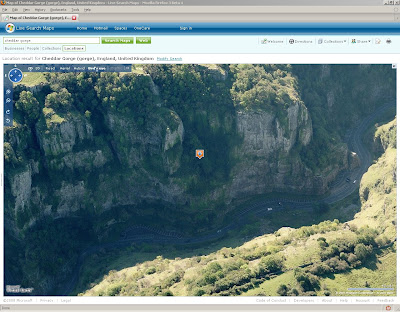
Cheddar

Cheddar Gorge BirdsEye View Live Maps
Cheddar Gorge in BirdsEye Mode
Cheddar Gorge 3D View Live Maps
Cheddar Gorge in 3D Mode

Harlow

Sawbridgeworth


Orthophoto's (Aerial)

Norwich


Ipswich

Cambridge

Hereford

Ludlow

Diddlebury Area

Coventry (South)

Bury St. Edmonds

Labels: , , , ,

26 March 2008

Postgres Plus Released (25-Mar-08)

Postgres Plus has been launched

"Postgres Plus is an easy-to-use lightning-fast and massively scalable open source database for today's Web 2.0 and next generation applications."

Postgres Plus
Postgres Plus benefits include:
  • Fully open source and pre-configured binary distribution supports the most popular environments, including Linux 32 and 64, Windows, and Mac
  • 5-minute install automatically delivers the most commonly needed PostgreSQL add-ons, including advanced encryption and client connectors for Java, Ruby/Rails, PHP, Ajax, J2EE, and REST/Web Services
  • Automated MySQL migration tools let you move existing applications in no time
  • Update notification service lets you know about important updates that need to be installed

*Postgres Plus is "spatially enabled", allowing it to be used as a back-end spatial database for geographic information systems (GIS) or any of the Mapping API's out there (Gooogle Maps API, Virtual Earth API, Yahoo Maps API('s), etc)).

Getting Started, with walk-through screenshots available
http://www.enterprisedb.com/learning/getting_started.do

Documentation
http://www.enterprisedb.com/learning/documentation.do

Download (Mac, Windows , Linux)
http://www.enterprisedb.com/products/download.do
(Windows Version is 116mb)


Please Note: "Postgres Plus Advanced Server (Developer)" is Free
Postgres Plus Advanced Server (Subscription) is $5,995 per socket


Postgres Plus is Compatible with PostGIS
http://postgis.refractions.net/

phpPgAdmin 4.2-Beta-2 is also available
http://phppgadmin.sourceforge.net/?page=download

Labels: , , , , ,

25 March 2008

MetaCarta - GeoSearch News

MetaCarta Launches New Web Site that Collects Local News from Around the World and Visually Displays it on a Map

Meta Carta GeoSearch News
Geographical Search News: http://geosearch.metacarta.com/

GeoSearch News lets users specify their place-of-interest by entering a place name in a text box or panning/zooming a map to a desired place or region. Users can refine their search by simply repositioning the map. Search results are presented in order of relevance as determined by a combination of keyword(s) and the specified geography.

“GeoSearch News is an entirely new way for people to find news on the web.
It combines the unique power of geographic search with keyword search and is the single place to find current news stories, from a wide variety of sources, about any place, quickly.”

MetaCarta Press Release

Labels: , , , ,

23 March 2008

SQL Server 2008 and Virtual Earth (WebGIS)

SQL Server 2008 and Virtual Earth - Looks to become a powerful online GIS (WebGIS)

Most Mapping Applications take data from a database, here users input (Points,Polylines & Polygons) and gets stored in a spatial database, After data is stored, the data can be used in simple analysis, buffering, interesecting, clipping etc. No need to have a desktop GIS anymore (?)

SQL Server 2008 as backend to WebGIS


"In the previous parts we have first been looking on the database side and how we can use various mechanisms to load and extract data and we even implemented a geocoder in the database. Then we moved on and investigated various ways to retrieve data from SQL Server 2008 and visualize them in Virtual Earth. In this final part we will now focus on using Virtual Earth as a simple data editor which allows us to write data back to SQL Server 2008."


14 tutorials using Microsoft SQL Server 2008 and Vitrual Earth


http://blogs.msdn.com/publicsector/archive/2008/03/22/virtual-earth-drawing-on-the-map-and-storing-the-result-in-sql-server-2008.aspx


Inserting a Polygon into SQL Server 2008
A polygon created and inserted into sql server 2008 on the fly.

Labels: , , , , ,

20 March 2008

Google Chart API - Maps New!

Quick update:
Overlaying Google Charts in Google Map (Via KML GeoXML Overlay)
http://mapperz.googlepages.com/chart_overlay.html

Google Charts API - Maps
New!

The Google Chart API lets you dynamically generate charts on the fly.


Google Chart API now generates thematic Maps.

From the Google Chart API Group:

"We released a new version of the Google Chart API. It adds many new features that you requested here in this group, for example sparklines, radar charts and thematic maps.

The most important change however is that we removed the limit on the number of requests. This means you can use the Google Chart API without worrying about reaching a limit.

For the documentation about the new features and usage policy please see the updated documentation page: "
http://code.google.com/apis/chart/

The example Chart API Map (above) can be generated with this url.
http://chart.apis.google.com/chart?cht=t&chs=440x220&chd=s:_&chtm=europe&chld=GB&chco=ffffff,edf0d4,13390a%20=GBFR&chd=s:Af9&chf=bg,s,EAF7FE

This would be good if you could overlay kml...
or overlay pie charts (or any other) onto a Google Map.

Other changes to the Chart API
  • Text encoding with data scaling New!
  • Bar chart zero line New!
  • Radar charts New!
  • Sparklines New!
  • Solid fill Extended!
  • Line styles Extended!
  • Shape and range markers Extended!
  • Required and optional parameters Extended!
  • Usage policy Extended!

Labels: , , , , ,

More UK Bluetongue Outbreaks Maps

More UK Bluetongue Outbreaks Maps (Defra)


More Bluetongue Maps
Defra have released layered pdf's (able to switch on and layers of detail)

*you can have Ordnance Survey MiniScale Maps for 'free' if you switch off all the layers and save - but your not going to do that are you?


"As at 14:00 on 19 March 2008 there were 110 confirmed premises affected by Bluetongue. The most recent cases were found as a result of pre-movement testing during the vector-free period. This figure will normally be updated weekly on a Friday where necessary."

http://www.defra.gov.uk/animalh/diseases/notifiable/bluetongue/pdf/map-bt-pzsz080319.pdf

(197kb)

Labels: , , , ,

18 March 2008

UK Debt Maps

UK Debt Maps

UK Debt Map Experian via the BBC News

http://newsvote.bbc.co.uk/1/hi/business/7301082.stm

"Nearly a third of the 5.7 million new problems dealt with by staff at Citizens Advice bureaux in 2006-7 concerned debt, making it the biggest single issue they faced."

Most indebted
1. Richmond-upon-Thames
2. Putney
3. Kingston-upon-Thames
4. Windsor
5. Wandsworth
Least indebted
1. Dumfries
2. Chesterfield
3. Merthyr Tydfil
4. Skegness
5.Bangor


Highest rises
1. Penzance
2. Bromley
3. Skipton
4. Eastleigh
5. Bromsgrove
6. Abergavenny
7. Newbury
8. St Helens
9. Beverley
10. Newark On Trent

PDFs (hosted on the BBC Site)
Total Debt Levels (2mb)
Year on Year Change (2mb)

Mortgage Debt (2mb & spot the mistake!)
Credit Card Debt (2mb)

Sources: BBC News
Experian and Experian Micromarketer G3

Labels: , , , ,

14 March 2008

Google Sky (Web Version) Released

Google Sky (Web Version)

Google Sky
Google have just released Google Sky (Web Version) - Works in the same way as Google Maps does, but you now look up from the Earth to view the Sky at Night.


Google Sky Web Version
Google Sky Web Version (English UK)
Date Collected from:
Digital Sky Survey
Digitized Sky Survey
Hubble Space Telescope.

"Select the thumbnail images at the bottom of the display to bring up the planets, the constellations, highlights from the Hubble Space Telescope, famous stars, galaxies and nebulae, views of the universe in the x-ray, ultraviolet and infrared"

Other items available through Google Sky:

Backyard Astronomy - Highlights the stars, galaxies and nebulae that can be seen with a pair of binoculars or a small telescope. These placemarks tell you about the celestial objects as well as providing links to sites such as Google Scholar where more detailed information can be found
Infrared - An infrared view of the sky from the Infrared Astronomical Satellite (IRAS). Change the transparency of this layer by moving the slide bar to blend the optical and infrared.

Microwave - A view of the microwave sky from NASA's Wilkinson Microwave Anisotropy Probe (WMAP), which shows the universe as it was 380,000 years after the big bang.

Historical - The sky as drawn by Giovanni Maria Cassini (printed in 1792) showing the constellations in their classical form from the collections of David Rumsey

Is the imagery different from Sky in Google Earth?
The images seen in Google Sky are identical to those found in Sky in Google Earth. Google have changed the projection to display these images within Google Maps (the Mercator projection). As with Google Maps this means that the northern and southern celestial pole cannot be shown.
Source: Google Sky Help Pages

Official Google Blog: http://googleblog.blogspot.com/2008/03/space-jam.html
Lat Long Blog: http://google-latlong.blogspot.com/2008/03/organizing-more-than-one-worlds.html

Labels: , , , ,

13 March 2008

BBC School Report Map 2008

BBC School Report Map using Microsoft Virtual Earth

BBC School Report 2008 Map Virtual Earth
"This is a map of schools taking part in School Report 2008. Navigate and zoom by using the buttons at the top left of the map. Click on a marker to find out about that school."

and in 3D...

BBC School Report 2008 Map Virtual Earth 3D

Map Feedback
http://news.bbc.co.uk/1/hi/school_report/7293814.stm

(Currently locations in 3D do not display the info window correctly)

*3D View requires Virtual Earth 3D (Beta) plugin pre-installed


Labels: , , , ,

12 March 2008

StreetView - MapJack vs Google

Update3 17/03/2008
MapJack adds Sausalito, CA, USA to the list.

Update2, 15/03/2008
http://wanderingken.com/loc/street.htmlhttp://wanderingken.com/loc/street.html
has draggable markers and 'flip' to streetview mode (full screen)
just needs the directional markers to complete the set.

Update Google Map API StreetView New! 13/03/2008
Working well here:
http://keirclarke.googlepages.com/streetviewapi.htm
(just need the drag human icon now)

unofficial documentation (Mike Williams)
http://econym.googlepages.com/reference.htm#GStreetviewClient
Example
http://econym.googlepages.com/temp_streetviewpanorama2.htm


StreetView - MapJack vs Google


MapJack
MapJack is designed to provide good looking pictures from cities all over the world, and to get the "immersive" feeling of actually being there.
MapJack feature three main functions.
Displays immersive panorama pictures. Map the current location in both the panoramic pictures and showing directions.
The search function, find street addresses and local businesses
MapJack Coverage:
San Francisco, USA Chiang Mai, Thailand
Coming Soon are:
Lake Tahoe
Yosemite National Park
Pacifica
Palo Alto
San Jose
Las Vegas

Here is a Video showing the functionality of MapJack in Thailand.


Full Help
http://www.mapjack.com/Help.html
Unlike the Google Maps StreetView you can do the following in MapJack
Brightness
Sharpness
Preload pictures
Show visual aids (compass,loading wheel, address information, movement and zoom buttons on screen.)
Show blue dots (MapJack Coverage)
Show grid (texture and projection mapping the picture.)
Quality - you can increase or decrease the Quality of the panoramic image.

Top Tip
Click and hold the radar beam near the 'Jack' (Icon) and panorama picture shows what Jack can currently see. The 'radar' beam coming out from under Jack is an indication
of what direction Jack is looking, and how wide he can see.

Privacy and legal issues.
MapJack panoramas are all captured on public property with the intention to show a city and it's features. If you feel that a picture contains unproper exposure use the
Feedback Form.

Google StreetView
Google StreetView released on May 29th, 2007 with a few cities in the US, now covering more cities in the US. 32 cities in fact


We are now watching you Google.


Google Maps API StreetView New! (good timing)
A very recent development (today 12/03/2008) has been the found but Mike Williams. Version 2.103 of the Google Maps API has had StreetView functionality added.

This is NOT official so not supported (as yet). Mike Williams has a few *temporary links* in which users can view this.


Shows todays progress.
Mapperz version

Well who wins?

In this case, it's unfair to say either is a clear winner, Mapperz prefers MapJack's 'User Interface' has more functions more interaction on the surroundings, while the might of Google tries to map and photograph every square inch of every US City (and told not to in places) they do have more coverage.

But MapJack wins on being the first location outside of the US (Chiang Mia, Thailand). Well done.
No UK yet but maybe in the near future (?)
So a draw? Well I think there is a learning curve for both - seeing both developments is innvotation in itself, hopefully they can learn from each others methods and
visualisation. Comments welcome on this.

Future of Streetview.
Privacy and security is the big issue. Some Countries even neighbours of the US are aware of there own privacy laws (Canada) Coverage need to be complied with.
This will be a big presence in the coming months and years, rumours and sightings of cars with 360 degree cameras on them are abundant. Even London

Labels: , , , , ,

11 March 2008

Deep Zoom - Sliverlight 2 Beta

Deep Zoom - Sliverlight 2 Beta
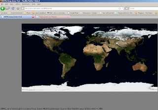
Deep Zoom Sliverlight Map
Deep Zoom requires silverlight 2 beta 1, works in firefox 3beta3.


This has potential - this is only one single image (4.1mb) but if you used quadtiles then the quality of the image when zooming would be preserved - this requires pre-processing and can be time consuming when dealing with high resolution images.
A Free Application 'MapCruncher' will produce tiles that can be used.
The extra item here is that you are not restricted to using raster data.
Vector Data can also be used.

Sliverlight highlights:

  • Custom branded experiences using 2D vector graphics, animation, styling, and skinning.
  • Highly sophisticated across major browsers on Mac, Windows, Linux, and devices.
  • HD video and adaptive streaming techniques for world-class media experiences.
  • Unparalleled interactivity with high resolution content through Deep Zoom technology enabling smooth browsing independent of screen size.

To Create 'Vector Tiles' there is a little known set of python scripts available here
http://research.microsoft.com/MapCruncher/TiledVectors/TiledVectorsDemo-1.1/description.html

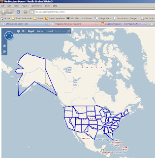
There is a demo that works straight from the download (USA States)

In Virtual Earth
Tiled Vectors_Virtual Earth 2D
Very Generalised when zoomed out.

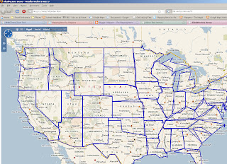
Tiled Vectors Virtual Earth 2D zoom

A Very Generalised Dataset but when you zoom in is much faster at displaying. Notice the less generalised data when zoomed in (this demo is purely to show the process).
When in 3D mode the Vector lines are rasterised on the fly.

Limitations - Polylines only - Polygon generalisation can be more demanding.

Combined the Four Products (Sliverlight, MapCruncher, TileVectors and Virtual Earth) and you have a nice production line for creating your own online/offline interactive maps.

Labels: , , , , , , ,

10 March 2008

ArcGIS 9.2 Service Pack 5 - Announcement

ArcGIS 9.2 Service Pack 5 - Announcement
The last service pack for ArcGIS 9.2 is due this month

Top Pick

NIM005856 - The Load Objects option does not work as expected.

NIM009501 - Windows NON-Administrator user cannot add a JPEG to an ArcGIS client such as ArcMap and ArcCatalog

NIM009632 - File geodatabase performance is poor when multiple computers whose names exceed 14 characters are accessing its data.

NIM010212 - The Multipart To Singlepart tool fails with polygon feature classes containing very thin parts

NIM011533 - ArcMap crashes after intersecting smoothed polygons

NIM012154 - Copy/Paste of a file geodatabase does not work correctly on Vista.

NIM013010 - Building a map cache from a compressed file gdb feature class can exhaust memory and lead to a crash.

NIM013246 - Representation symbology does not display correctly when a join is present

NIM013456 - Export to Shapefile fails when the underlying feature class contains a BLOB.

NIM031256 - Cartographic line symbols intermittently do not maintain CMYK color values when exported to EPS format from ArcMap.

NIM031622 - Export Dataset does not properly set the associated feature class in some cases.

Full List
http://support.esri.com/index.cfm?fa=downloads.patchesServicePacks.
viewPatch&PID=66&MetaID=1381

Labels: , , , ,

07 March 2008

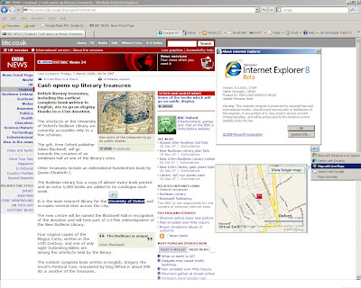
Internet Explorer 8 (Beta) - Mapping Placename Locations

Internet Explorer 8 - Map Locations fast


Simple and useful - Select a placename on a webpage (BBC News in this example)

Right click and get a map of the selected text.

This is 'geocoding' on the fly using selected text and sending a request to Microsoft Live and return the Map in the overview window.

IE8 Map Live Geocoding
Note: Map Overlay moved to show selected text
News Page Source: BBC News

IE8 is available (for developers) - Release notes here
Please note this is in 'Emulate IE7' mode as the 'tooltips' seems to be disable in IE8 Mode.

Typically you only get Microsoft Live Maps....
** Double clicking on the map zooms in but no option for zooming out, or changing map mode.
*** Route from here could be easily implemented from this.

Labels: , , , , , ,

06 March 2008

Master Class: Creating Custom Maps

Creating Custom Maps with John Coryat

How do you do 'Custom Tiles' in Google Maps?

An excellent presentation explains it all.

Software/scripts required
Perl 5.8 with DBI, GD and CGI modules
USNaviguide_Google_Relpix Perl module
USNaviguide_Google_Tiles Perl module
PostgreSQL 8.2 with PostGIS Extension (Mapperz recommends PostgreSQL)
Apache 2.0 webserver
ProjectedImage.js (Javascript)
US Census Cartographic Boundary County Shapefiles
Geonames.org US.zip data file

Or the PDF version

http://www.usnaviguide.com/ws-2008-02/presentation.pdf(5.5mb file)

Examples and Presentation Materials
http://www.usnaviguide.com/ws-2008-02/download.zip (111mb file)

Well done http://maps.huge.info/blog

Labels: , , , , ,

05 March 2008

OpenSpace Tiles in Google Earth

update: 38 second clip on You Tube by request - video capture by SnagIT

OpenSpace Tiles in Google Earth

"Gavin Brock has produced an Ordnance Survey Overlay for Google Earth which enables you to view public footpaths in Google Earth. Unfortunately the kml of the overlay doesn’t appear to work when loaded into Google Maps." Google Maps Mania

Not sure on the legal aspects (OS Copyright) on this but it is impressive to see 1:50,000 Landranger Series in 3D. Some footpaths are available but 1:25,000 (Explorer Series) is the official scale for public footpaths and rights of way, currently 1:25,000 is not available in the Openspace API.

Labels: , , ,