->

29 November 2010

Olympic Park Ordnance Survey Map

Olympic Park Ordnance Survey Map

Olympic Park Ordnance Survey Map
Olympic Park Ordnance Survey Map Progress

"Hopefully it will give you a taster of the development that has taken place on the site since 2001 and the contribution that Civil Engineers have made."

Full PDF available at
http://blog.ordnancesurvey.co.uk/2010/11/mapping-the-olympic-park/

Labels: , , ,

19 April 2009

The Times: Best walks in the British Isles with Maps

The Times: Best walks in the British Isles with Maps
The Times are promoting the best of British walks with the use of custom made route maps and Google maps.
The Routes are also available for Mobile Phones:
http://timesmobile.mobi/walks

Here are the 20 Walks in PDF Format

All have Blister Ratings, Pub Ratings and View Ratings.

1. Alfriston - Seven Sisters, East Sussex, by Alan Franks
2. Oxford - Wolvercote circular by Libby Purves
3. Branscombe to Beer, Devon, by Monty Halls
4. Land's End to Nanjizal by Alex Wade
5. Withypool, Exmoor, Somerset by Alice Thomson
6. Porlock Weir to Culbone Church, Exmoor, Somerset by Joe Swift (Porlock Weir spelling is wrong on the pdf)
7. Oxwich Bay, Gower Peninsula, Wales by Kate Humble
8. Brecon Beacons Horseshoe, Wales, by Damian Whitworth
9. Snowdon via the Pyg Track, Wales by David Aaronovitch
10. Malham Cove , Yorkshire Dales by Matthew Hoggard
11. Muker-Keld, Yorkshire Dales by Ann Treneman
12. Seathwaite - Scafell Pike, Lake District by Giles Whittell
13. Ullswater, Lake District by Hunter Davies
14. Arthur's Seat, Edinburgh by Hugo Rifkind
15. Skipness-Claonaig, the Kintyre Way, Scotland by Ben Macintyre
16. Sileve Binnian, Mourne Mountains, Northern Ireland by David Sharrock
17. Chew Green, Northumberland by Christopher Somerville
18. Blythburgh - Eastbridge, Suffolk by Simon Barnes
19. Wells-next-the-Sea to Cley, Norfolk by Richard Morrison
20. The New River and the Lee, Hertfordshire by Derwent May

**There seems to be a copyright acknowledgment issue here - some pdf's reveal that there is Ordnance Survey 1:50,000 rasters underneath the 'walking route maps' but there is no crown copyright acknowledgment on the map or pdf's. Hope the Times realize this is breaking crown copyright.

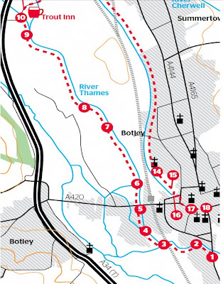
2 Botleys no Oxford
Two Botleys on the - map confusion - No Oxford? - Summertown sliced off and where are the toilets? No Scale? No copyright**? [image for illustration only]

Cartographically these maps are not the best - the editors missed the importance of Toilets on the routes and there are various spelling mistakes and label mis-placement but they do guide you for their purpose.

They do also presume you have the relevant Ordnance Survey Explorer Maps [1:25,000].
These can be viewed from Multimap [OS Map mode] and Where is the Path for free.

Labels: , , , , , ,

20 August 2008

Free Maps for Education (in PDF format)

Free Maps for Education (in PDF format)

Maps International
have release free maps in A3 paper size
(297mm×420mm or 11.7''×16.5'')

Maps International Educational Free Maps - Europe
Politically coloured Europe map for Free

Maps International Educational Free Maps - World
This World Map is available for educational use at not cost.
(Politically coloured World map with hill shading and bathymetry.)

"Maps International Education shop provides education wall maps and geography teaching resources and aids for all ages. Our product range is extensive and includes the new exclusive Primary Schools wall maps. Also available to purchase are key geography texts for higher and further education including subjects such as Earth Sciences, Regional and Area Planning and many more Geography based subjects."

Other Free Maps available:
  • UK map with major transport links including motorways, primary routes, ferry routes and airports.
  • UK map with major transport links including motorways and airports.
  • UK map with parliamentary boundaries and names.
  • Wales map with country/ county/ district/ unitary boundaries and names
  • Scotland map with country/ county/ district/ unitary boundaries and names
  • England map with country/ county/ district/ unitary boundaries and names.
  • Europe map with hill shading and hypsometry.
  • Outline black and white World map with country borders, capitals and country names.
  • Outline black and white World map with country borders only.

These Maps in PDF format are available from
http://www.mapsinternational.co.uk/education_downloads.asp

TERMS OF USE
All material is copyrighted and should not be reproduced for commercial use. If you intend to use the free resources for anything other than classroom use, then contact Maps International on Free Phone 0800 038 6277 or sales@mapsinternational.co.uk to discuss the cost and royalties applicable. No responsibility can be assumed for the accuracy of the information given.

Labels: , , , , , , , , ,

22 April 2008

OpenStreetMap Now Exports Maps!

OpenStreetMap Now Exports Maps!

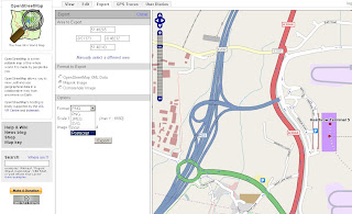
Open Street Map Export Maps
Need a map for Terminal 5 now you can export to PNG,JPEG,PDF,SVG or Postscript (for Mapnik Image style)

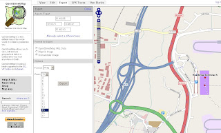
Open Street Map Export Maps Formats
Osmarender Image output is PNG or JPEG

Nice and easy function gives users the ability to export the map they see to a map in different formats.

"And this is just the start - our mailing lists are already buzzing with possibilities for new formats, such as Adobe Illustrator for cartographers, or shapefiles for GIS professionals."

http://www.openstreetmap.org/


source: http://www.opengeodata.org/?p=290

Labels: , , , , , ,

20 March 2008

More UK Bluetongue Outbreaks Maps

More UK Bluetongue Outbreaks Maps (Defra)


More Bluetongue Maps
Defra have released layered pdf's (able to switch on and layers of detail)

*you can have Ordnance Survey MiniScale Maps for 'free' if you switch off all the layers and save - but your not going to do that are you?


"As at 14:00 on 19 March 2008 there were 110 confirmed premises affected by Bluetongue. The most recent cases were found as a result of pre-movement testing during the vector-free period. This figure will normally be updated weekly on a Friday where necessary."

http://www.defra.gov.uk/animalh/diseases/notifiable/bluetongue/pdf/map-bt-pzsz080319.pdf

(197kb)

Labels: , , , ,

04 January 2008

Graphics and Shapes Extension for ArcGIS

Graphics and Shapes Extension for ArcGIS 9.2

11/08/2008
A few extra functions have been added:
  • Added “Build Polygon” function
  • Added Polyline Azimuth options to “Calculate Geometry” tool.
  • Multiple minor edits to code and manual, described in full in manual.
  • Build 1.1.76 (January 10, 2008) Corrects a bug where the Spheroidal Length was being written to the wrong field.
version 1.1.76
http://arcscripts.esri.com/details.asp?dbid=15376

"Description: This extension includes a large suite of tools for calculating geometric attributes of vector features and for selecting and naming graphics. All tools are available at the ArcView license level."

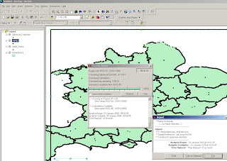
Jeff Jenness Graphics Shape Tools for ArcGIS Results
Cleaner and Faster than conventional 'ESRI' Toolsets (and a progress bar that works)


Jeff Jenness Graphics Shape Tools for ArcGIS
Simple layout of functions - much better than those geoprocessing tools in the toolbox you can never find the name for.

Tools for Graphics
Graphic Elements to Shapes
Select Graphic Elements by Type
Select All Graphic Elements
Unselect All Graphic Elements
Flip Graphic Element Selection
Zoom to Selected Graphic Elements
Name Graphic Elements
Tools for Shapes
Convert Polygons to Label Points
Convert Shapes to Centroids
Convert Shapes to Spherical Centroids (detailed method explained in PDF)
Convert Shapes to Vertices
Convert Polylines to Polygons
Convert Polygons to Polylines
Split Multipart Features
Combine Features
Calculate Geometry


"Jeff Jenness is an independent GIS consultant specializing in developing analytical applications for a wide variety of topics, although he most enjoys ecological and wildlife-related projects. He spent 16 years as a wildlife biologist with the USFS Rocky Mountain Research Station in Flagstaff, Arizona, mostly working on Mexican spotted owl research. Since starting his consulting business in 2000, he has worked with universities, businesses and governmental agencies around
the world, including a long-term contract with the United Nations Food and Agriculture Organization (FAO) for which he relocated to Rome, Italy for 3 months. His free ArcView tools have been downloaded from his website and the ESRI ArcScripts site over 190,000 times."

Full and comprehensive documentation (in PDF Format)
http://www.jennessent.com/downloads/Graphics_Shapes_Online.pdf

Source:
Jenness, J. 2008. Tools for Graphics and Shapes: Extension for ArcGIS. Jenness Enterprises.
Available at: http://www.jennessent.com/arcgis/shapes_graphics.htm

Labels: , , , , ,

02 October 2007

'At-Risk' Post Office Outlets Mapped

last update:
Yorkshire area
http://mapperz.googlepages.com/yorkshire_post_offices
_at_risk_name.html


Outreach Post Offices Planned (replacing these Post Offices)
http://mapperz.googlepages.com/outreach_post_offices_named.html

data from...
http://news.bbc.co.uk/1/shared/bsp/hi/pdfs/02_10_07_po_total.pdf
so if that is wrong so will the location on the map

update:

Midlands is Mapped now.
http://mapperz.googlepages.com/Midlands_post_offices
_at_risk_named.html
*Starkholmes, 133 Starkholmes, Road Matlock E4 5JA was not mapped due to an incorrect postcode.

Kent 'at-risk' Post Office Outlets Mapped


"The Post Office has announced the first 180 branches earmarked for closure under its plan to shut 2,500 by the end of next year."

based on the pdf on the BBC website - Mapperz mapped them. In 15 minutes
http://news.bbc.co.uk/1/hi/uk/7023244.stm


How was this done so quick?

  • Copy and pasted addresses and postcodes from the PDF into notepad, save as .txt
  • Rename as .csv
  • Open this in OpenOffice (or Word) as comma delimited.
  • Adjusted the Postcodes into one column
  • Appended the lat/lng to the Post Office 'at risk' in OpenOffice
  • Saved as .xls
  • Published this as 'public' (will not work if your don't)
*to create the link between the spreadsheet and google map via the Public Spreadsheet Key.
**the wizard does do a lot of things, icons sizes, colours, viewport, map extent based on data.
The Mapperz modified a little html to make the map centre on Europe before zooming to the Kent era.

View the 'At Risk' Post Offices in Kent Map

Mismatched postcodes with the geocoder
Kent had one Postcode that was incorrect replacing the 'I' for a '1' worked.
TN13 IHZ should be TN13 1HZ

Labels: , , , , , ,

07 August 2007

Foot and Mouth Map - Surrey

Update - a second outbreak confirmed (11am BST 07/08/07)

A Second Outbreak Foot and Mouth Map
More info on the Defra and BBC News pages

Foot and Mouth Map - Surrey (UK)


"Following an investigation of suspected vesicular disease by Animal Health on a holding near Guildford in Surrey, laboratory results on Friday evening, 3 August indicated the presence of the Foot and Mouth Disease (FMD) virus in samples from cattle on the premises."
Source: Defra

here is the map (available as a pdf here)
Defra Foot and Mouth Map - Surrey UK

What is foot and mouth? (wiki)

The interactive version is now available.
http://www.gisdiseasemap.defra.gov.uk/intmaps/FMD/map.jsp
Defra Foot and Mouth Interactive Map - Surrey

More information on the BBC News Website

Mapperz

Labels: , , ,

04 March 2007

Ordnance Survey New Product - Sitemap™

Ordnance Survey Releases A New Product - Sitemap™

Ordnance Survey Sitemap™
Image Source: Ordnance Survey

"OS Sitemap provides customers with extracts of Ordnance Survey mapping in a number of different formats and to different scales. It is has been developed to suit the requirements of a broad range of customers - from private individuals requiring a paper map to large design and engineering organisations wanting map data to be used within a computer system."

OS Sitemap provides a detailed and seamless view of topography of Great Britain:
Three scales
  • 1:1250 (Derived from OS Master Map)
  • 1:2500 (Derived from OS Master Map)
  • 1:10 000

Available in Paper (Colour or Black and White)
Raster Images (LZW compressed Tiff or PDF format)
Vector (DXF but not NTF or GML)

But is it cheap?
No, cheaper than OS Master Map but for Personal use and even small businesses it is expensive. Use Open Street Map (free) as an alternative instead.

Prices, the PDF just points to Sitemap at the end available at Ordnance Survey Mapping and Data Centres, it depends on a number of factors

Raster or Vector formats
Colour or Black and White
Size of Area needed
and complex pricing structuring dependant on your use, commercial vector on a website will lead to many ££££.

To find your nearest stockist

60 Layers of Features however here are some that are Not included are

Roads under 100 metres (Private Land)
Rights of Way
Detail under bridges (so captured from aerial photography and not surveyed?)
Detail under elevated roads
Buildings below a minimum size (resolution of image not high enough to capture it?)
Land parcel areas and House Numbers

Good for Ordnance Survey to create new digital products, however they need to make purchasing and costs more accessible to the public.
If they reduce prices they would gain more customers and not scare many off with complex pricing, are all 47% of Ordnance Survey is paid by the tax payer.
so do UK tax payers with get a 47% discount with that?

mapperz
likes OS products and uses them most days in a commercial sense, though OS need to make it easier and cheaper for Joe Public to use it for personal use.

Labels: , , , , , , , , ,