->

30 December 2010

OpenTripPlanner Portland

OpenTripPlanner Portland

A trip planner with a difference

"A trip planner helps you figure out how best to get where you want to go. A multi-modal trip planner lets you plan routes using multiple "modes," for example, on foot, bike, train, bus, or some combination thereof. A good multi-modal trip planner allows you to easily tailor your trip to your preferences, for example by eliminating transfers, walking a more scenic path, or only riding buses with bike storage."

What is OpenTripPlanner?

OpenTripPlanner is an open source multi-modal trip planner. It brings together work from a number of existing open source projects, including Graphserver, OneBusAway, and FivePoints, and aims to be easy-to-use, flexible, reliable, and fast.
OpenTripPlanner Portland
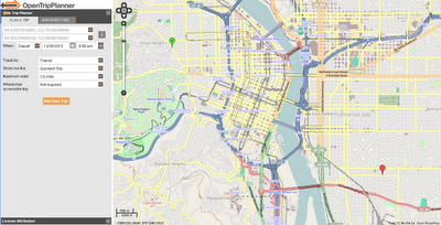
Planning a trip is very straightforward - right click to create start point and right click to add destination.
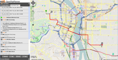
OpenTripPlanner Portland Route
Lots of Options - like Transit only - with changes includes - clearly laid-out.


For Developers
  • Plans true multi-modal trips combining walking, biking and transit
  • Plans wheelchair accessible trips
  • Plans depart by/arrive by trips
  • Takes road type, bike lane, and elevation data into account when planning bike trips
  • Show elevation maps for bike trips
  • Imports data from GTFS, shapefiles, OpenStreetMap, and the National Elevation Dataset
  • Plans trips in about 100ms in a moderate sized city
  • Exposes a RESTful API (XML and JSON), which other apps or front-ends can build on

Try the OpenTripPlanner for Portland
http://maps5.trimet.org/otp/

wiki for developers
http://opentripplanner.org/wiki

Labels: , , ,

24 December 2010

Pegmans Gets A Hat

Pegmans Gets A Hat

Pegman finds a Hat
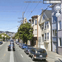
Pegman gets a Christmas hat for the weekend? http://goo.gl/maps/jAgL

Predictions - 2011 will bring,

A new perspective to old fashioned raster maps... with the help of HTML5.

OpenStreetMap will go mainstream... more so than at present.

AddressPoint (UK Postal Address locations) become more accessible without huge costs.

Fusion Tables SPATIAL will improve vastly.

Best of 2010 mapping
Opendata from Ordnance Survey. (No April Fools there)

Ovi Maps downloads maps via wifi to phone (no more Ovi Suite!)

Bing Maps Apps more usable adding OpenStreetMap.

MapQuest pump $1million in Open Source Data.

Labels: , , , ,

16 December 2010

OS OpenSpace & Google Maps v3 Meet

OS OpenSpace & Google Maps v3 Meet

Another great example from Bill Chadwick

OS OpenSpace & Google Maps v3 Meet
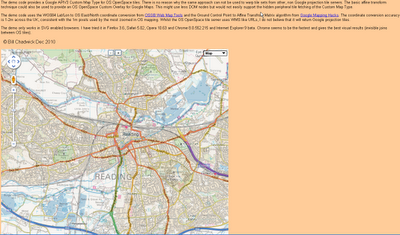
Merging Map Tiles Ordnance Survey and Google Maps based on v3 Google Map API

"The demo code provides a Google APIV3 Custom Map Type for OS OpenSpace tiles. There is no reason why the same approach can not be used to warp tile sets from other, non Google projection tile servers. The basic affine transform technique could also be used to provide an OS OpenSpace Custom Overlay for Google Maps. This might use less DOM nodes but would not easily support the hidden peripheral tile fetching of the Custom Map Type.

The demo code uses the WGS84 Lat/Lon to OS East/North coordinate conversion from OSGB Web Map Tools and the Ground Control Point to Affine Transfrom Matrix algorithm from Google Mapping Hacks. The coordinate conversion accuracy is 1-2m across the UK, consistent with the 1m pixels used by the most zoomed in OS mapping. Whilst the OS OpenSpace tile server uses WMS like URLs, I do not believe that it will return Google projection tiles.

The demo only works in SVG enabled browsers. I have tried it in Firefox 3.6, Safari 5.02, Opera 10.63 and Chrome 8.0.552.215 and Internet Explorer 9 beta. Chrome seems to be the fastest and gives the best visual results (invisible joins between OS tiles)."

Full credit to Bill Chadwick

View the Map

http://wtp2.appspot.com/warpdemo.htm

Labels: , , , ,

14 December 2010

File Geodatabase API BETA - January 2011

File Geodatabase API BETA - January 2011

File Geodatabase API  BETA - January 2011
Image source: ESRI - File Geodatabase API announced.

The File Geodatabase API provides a non-ArcObjects based means by which advanced developers can work with File Geodatabases. The File Geodatabase API will be C++ based and will provide the ability to perform the following tasks:
  • Create, Open and Delete file geodatabases
  • Read the schema of the geodatabase
All content within a geodatabase can be opened for read access
  • Create schema for objects within the simple feature model
  • Tables
  • Point, Line, and Polygon feature classes
  • Feature datasets
  • Domains
  • Subtypes
  • Read the contents of datasets in a geodatabase
  • All dataset content within a geodatabase can be read
  • Insert, Delete and Edit the contents of simple datasets:
Tables
  • Point, Line, Polygon, Multipoint, and Multipatch feature classes
  • Perform attribute and (limited) spatial queries on datasets
  • Spatial queries will be limited to the envelope-intersects operator
  • Navigate relationships and work with Attachments
This API is targeted for advanced developers who require access to the File Geodatabase without an ArcObjects license for purposes of interoperability. A commonly requested user scenario is to open File Geodatabase tables outside of an ArcObjects based application to view or modify data. This API does not replace ArcObjects as the recommended approach to interacting with the geodatabase.

The File Geodatabase API leverages the work done in ArcGIS 10 to simplify the Geodatabase system tables. Therefore, the File Geodatabase API only supports file geodatabases from release 10 or later. We are planning to deliver the API as a single downloadable ZIP containing:

C++ library (single dll, lib, .h)
API documentation in html format
(Supported on Windows only for the initial release)

Limitations of the File Geodatabase API

While the File Geodatabase API will support reading the schema and data of complex geodatabase types, the API will not honor geodatabase behavior on inserts, deletes or updates to the following dataset types:

  • Annotation and Dimension feature classes
  • Relationship Classes
  • Networks (GN and ND)
  • Topologies
  • Terrains
  • Representations
  • Parcel Fabrics

The API will not prevent users from attempting to edit objects with complex behavior, the onus will be on the developer to understand what they should and should not edit through the API and avoid editing datasets that have geodatabase behavior. There will be a method called Table::IsEditable which will provide developers with the ability to determine whether a dataset can be safely edited.

Other limitations of the File Geodatabase API at its initial release:
  • Rasters (Raster Dataset, Raster Catalog, Mosaic Datasets and Raster Attributes) are not supported with the initial release of the File Geodatabase API.
  • Spatial queries with the File Geodatabase API will be limited to the envelope-intersects operator.
http://blogs.esri.com/Dev/blogs/geodatabase/archive/2010/12/13/File-Geodatabase-API-details.aspx

source:
http://slashgeo.org/2010/12/14/ESRI-Announces-File-Geodatabase-API-Details

Labels: , , ,

13 December 2010

Google Zeitgeist Mapped

Google Zeitgeist Mapped

Based on the aggregation of billions of search queries people typed into Google this year.


Labels: , , ,

06 December 2010

Google Earth Engine

Google Earth Engine

Google Earth Engine
Image from Google Maps Mania
Google Earth Engine uses Google Maps and Google Earth to present satellite imagery and current and historical data to enable global-scale monitoring and measurement of changes in the earth’s environment.

Using Earth Engine you can browse though the data catalog and select to view satellite imagery from MODIS and Landsat 5. If you then select 'workspace' you can view the satellite imagery overlaid on Google Maps.

Each satellite imagery data set comes with a timeline slide control, so you can select the date of the imagery you wish to view. The Map Gallery section allows you to browse through maps created by Google's launch partners and the Earth Engine team.

Cross-Posted from Google Maps Mania
http://googlemapsmania.blogspot.com/2010/12/google-earth-engine-launched.html

Labels: , ,

02 December 2010

Google Earth 6

Google Earth 6


For
PC

Windows XP, Windows Vista or Windows 7

Mac
Mac OS X 10.5.0 or later

Linux
LSB 4.0 (Linux Standard Base) libraries


Google Earth lets you fly anywhere on Earth to view satellite imagery, maps, terrain, 3D buildings, the ocean and even galaxies in outer space. Explore rich geographical content, save your toured places and share with others. Download the latest version free of charge.

Google Earth 6 Features

  • Zoom from outer space to Street View

  • View buildings, bridges and trees in 3D

  • Find locations, driving directions and more


http://www.google.co.uk/intl/en_uk/earth/index.html

Labels: , , , ,