->

30 January 2007

Spatial Join (Analysis) Returns to ArcGIS

Spatial Join returns to ArcGIS 9.2, This function has been missing since ArcView 3.x, which is a much needed function in the GIS field.

This geoprocessing function is found in Analysis Tools>Overlay>Spatial Join

Please note this function is not Spatial Join by attributes as in previous versions of ArcGIS nor the Join on the tables.

This Spatial Join (Analysis) is by the features location.
"Creates a table join in which fields from one layer's attribute table are appended to another layer's attribute table based on the relative locations of the features in the two layers."

There is are three very powerful new functions also available in this example.
This quick example is setting up the Spatial Join selecting the Rivers that fall with different countries and assigning the river with a country name using intersect
.
Data is from the ESRI DVD World Data that was shipped with ArcGIS 9.2

Spatial Join (Analysis) Window
The spatial join using one to many on intersect features


Spatial Join (Analysis)in Model Builder
Using the Model Builder to create this process (yes there are new funky shapes in model builder)

Spatial Join (Analysis)in Iteration Mode Model Builder

Model of Spatial Join but with 3 Iterations using values in the search radius (10, 20, 30 kilometres are examples)

The batch can be created by right clicking the saved model and selecting batch.
More info on batch set ups here

Labels: , , , , ,

29 January 2007

Cartographic Representations - OverPass (Part 5 ) of...

Cartographic Representations are a big leap in ArcGIS 9.2

It allows the GIS/Cartographer more control on how the Map is displayed and this has been covered in Parts 1-4.
Part 4
Part 3
Part 2
Part 1

However this is part 5 but on requests from regular blog readers and ArcGIS users, there will be more examples on Cartographic Representations.

The gap between ESRI USA and ESRI UK Users has been 2 months hence why this post has taken so long to get on the blog. Mapperz has only used ArcGIS Desktop 9.2 Arc/Info for 2 days, one day was updating all the service packs

Please note this functionality is only available with ArcGIS Desktop Arc/Info (the super expensive one)

Carto what? Overpasses??
Cartographic Representations Overpasses Image source ESRI
Image Source: ESRI
  • Generates mask polygons at the intersections of stroke representations to symbolize one set of strokes passing above the other. Optionally, linear parapet features can be generated adjacent to these masks.
  • Requires intersecting line features symbolized with stroke representations as inputs.
  • Feature classes without representations are not supported by this tool.
  • The Input Above Features With Representations layer can be the same as the Input Below Features With Representations layer in the case of self-overlapping features.
  • When Input Above and Input Below representations are the same, a SQL expression is encouraged for further refinement of feature selection.
  • Overpass masks are created based on the user-indicated margin sizes.

This post covers Overpasses (where a road overpasses a railway/railroad).

This Tool is found in Cartography Tools > Symbolization Refinement > Create Overpass

First you need a Cartographic pair of representations to be able to do this. Mapperz is using the Examples are using the ArcGIS Tutorial >ArcTutor\Representations\Exercise_1.mxd

Convert Symbols to Cartographic Representations

Converting to Representation

Representations Overpass Function
OverPass dialog in ArcTool Box in ArcMap 9.2

Representations Overpass Processing
Processing.... yawn.

Representations OverPasses Completed

Result - This has been emphasized in Red and larger than normal for a project to create OverPasses.

The same method can be also applied to UnderPasses

Stand-alone Maplex user? (Not ArcMap Labelling Extension)
Underpass/Overpass can be exported to shapefile format and used to mask road/rails etc for Adobe Illustrator export (recommended as ESRI Export still not quite there from ArcMap).

Labels: , , , , , , ,

28 January 2007

Google Book Search Adds Maps

Google Book Search Maps

Google Book Search Adds Maps
Around the World in 80 days

Google Book Search now includes maps based on the content of the book.

More info on the Offical Book Search Blog

Around the World in 80 days
http://books.google.co.uk/

Mapperz

Labels: , ,

27 January 2007

RSS Feeds to GeoRSS Maps

RSS Feeds to GeoRSS
GeoRSS Blog Feed Mapperz Google Map
RSS?
GeoRSS?
Give your posts the spatial location element with http://exploreourpla.net/
converts your rss/atom feeds into maps in seconds.

RSS to GeoRSS Mapperz Blog Feed

To add your rss feed simply go to
http://exploreourpla.net/georss +url of RSS feed in full

Example
http://exploreourpla.net/georss/http://mapperz.blogspot.com/rss.xml
http://exploreourpla.net/georss/http://mapperz.blogspot.com/atom.xml

More info
Source:geonames.org
Related:addressfix.com

Mapperz

Labels: , , , , , ,

26 January 2007

LookLocal Maps (now beta 2)

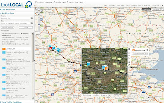
LookLOCAL is an online mapping and location based search site. Access and compare data from Google Maps, Yahoo! Local Maps, and Live Search Maps. View over 6,000 traffic cams, import your own KML layers. LookLOCAL is becoming a personalised online mapping portal.

LookLocal Maps Google with Driving Directions

"We built the site to integrate the search results and data from the three main online map providers. The idea being that it provides the user with the best of all three through a single seamless interface. Thanks for pointing out the zoom box. I've seen those and they are helpful for navigating. The zoom tool on our site is a thin client version of our patented Pliable Display Technology. The idea behind this type of visualization is that you can view additional detail without zooming the bigger picture (your context) off of the screen.

LookLocal Maps Live Local with Driving DirectionsLookLocal Maps Yahoo Map with Driving Directions

The beta 2 version now includes traffic cameras (North America and the UK), listings for some of the world's favourite travel destinations, and the ability to represent multimedia files on a map.

A worthwhile look at the development labs to for:

  • LookOUT is a great new add-in for Microsoft® Outlook® that enables you to easily map a location or find directions straight from your Outlook Contacts window.
  • The new LookLOCAL toolbar extension for Firefox® allows you to map search results or find directions directly from your Firefox browser toolbar.
  • LookWMS is a PDT-enabled Java Web Map Client with several unique features that enable you to access maps from servers that implement the OpenGIS® WMS specification.

Mapperz

Labels: , , , , ,

25 January 2007

Tag Maps - Explorer Maps

Tag Maps - World Explorer, Night Explorer & Trip Explorer

"TagMaps are a new way to visualize text on geographic maps. TagMaps can be used to communicate key characteristics of location-based data in an easy-to-understand way."
  • Visualise text (tags) geographically on a Yahoo! Maps.
  • Where Flickr tags are added to map for easy locating
World Explorer, Night Explorer & Trip Explorer Maps

There are three types of map available:
More Information at the FAQ
Yahoo! Map Developer API

Source: ProgrammableWeb

Mapperz

Labels: , , , ,

GPolygon Example - Google Maps API

Updated with New Content and New Links

Mapperz was Googled on the Official Google Map Blog

"Some of you have probably noticed (<-mapperz link) that we've added a new tool to your Google Maps API toolbox, the GPolygon. Just think of all the colorful triangles, octagons, hendecagons, icosagons, etc. that you'll be able to overlay on your map. I'll be really impressed if someone is able to build a googolgon, a polygon with 10100 sides."

More details about the GPolygon class can be found in the Maps API reference.

Permalink

Posted and thanks to Brandon Badger, Product Manager, Google Maps API.

Mapperz also wants to thank all the Google Maps API Group and all the helpful mappers out there.
Important Google Map People
Mike Williams
ESA also inspired mapperz with the polygon fill and bouncy icons
Pamela Fox (now Google Employee, )

Google Maps API 2.69 GPolygon Simple Topology Example

The orginal post

update 19/01/2007
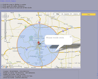
Live Link to the Gpolygon example - a filled polygon with an outline - this is testing if a polygon is inside or outside a mouse click or mouse movement defined by a user, but can be used to find markers/icons that fall inside a polygon - this method is called simple topology (points that fall inside a polygon).

update2
Circle Topology using the Gpolygon method

Google Maps GPolygon Topology Circle

live link and more clever google maps api trickery

more Gploygons

Stars Circles GPolygons

Example to show people what can be done with GPolygon
(stars, circles, polys):

25/01/2007

Last update on this hot topic

Official Post by
  • We define several utility functions to aid in generating random numbers and colors
  • When the map is clicked, we find the clicked pixel using fromLatLngToPixel on the result of G_NORMAL_MAP.getProjection().
  • We start generating random variables for small radius, large radius (used for stars), number of sides, and color.
  • If the draw mode selected is polygon, we iterate from 0 to number of sides. In each iteration, we calculate the new pixel location using good old trigonometry. We convert the pixel back to latitude/longitude using fromPixelToLatLng and add it to our points array.
  • If the draw mode selected is a star or circle, the process is almost the same. For stars, we iterate twice as much as the number of sides, calculating points at the large radius on the odd iterations. For circles, we ignore the randomly generated number of sides and always iterate 20 times around the clicked pixel for a nice round look.
  • Now for the magic - we create a new GPolygon with the points array and style parameters, and add it to the map.
  • Now here's the challenge: my own example is pretty useless, except for its teaching value. How can you put GPolygon to work for your app? Exploit the GPolygon for all it's worth (and don't forget its friend, GPolyline), and ping us with your creations on the forums.

http://googlemapsapi.blogspot.com/2007/01/gpolygon-example.html

Labels: , , , , ,

24 January 2007

ArcGIS 9.2 is Delivered to UK Users

ArcGIS 9.2 is Delivered to UK Users

UK Users can finally get there hands on ArcGIS 9.2 (Arc/Info, ArcEditor and ArcView)

Though a few surprises lurk:
  • DVD only (Lots of CD only users beware)
  • No Service Pack 1 included
  • Documentation is in PDF format (no hardcopy unless you print them)
Though there is one useful leaflet called ArcGIS Desktop - A Selection of Time-Saving Tips and Shortcuts (This will be put to the test).

Cartographic Representations part 5 coming soon.

Mapperz recommends installing the updated version of the Service Pack1
updated on the 9th January (43.7mb)

Also use the ArcGIS 9.2 Help Web Version
as is more up-to-date than the desktop installed version

Source: Mapperz

Labels: , , , , , ,

23 January 2007

Oblique Aerial Photos & More 3D Buildings Windows Live Local / Virtual Earth

Some nice 3D Photographic Images coming from Microsoft is are making their way through Windows Live Local / Virtual Earth

High Res Oblique Aerial Monte Carlo
Monte Carlo


Textured 3D Buildings in Miami
Miami in 3D
(use IE7 with 3D Virtual Earth Plugin pre-installed)

Source: Virtual Earth Blog

Labels: , , , , , ,

U-turns Google Maps Directions

Some advanced driving needed...
U-turn Google Map Directions

and 246 U-turns later

246 U-turns Later Google Map Directions

Source:theinquirer

link to google map directions

mapperz

Labels: , ,

22 January 2007

Google Analytics to Google Earth

Google Analytics to Google Earth

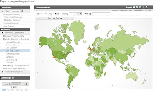
Mapperz Analytics PageMapperz Analytics GeoMap Overlay


In Google Analytics, open Marketing Optimization, then Visitor Segment Performance.
Click on Geo Map Overlay and you get their best world-map overlay.
If you look at the upper right of the data window, you see an Export section, and the first icon is a T.
Click it and cut the data out, then paste it here and hit Submit.
source:Analytics2KML

This file is returned to your browser with the proper MIME type for Google Earth,
and upon submission it may open up in Google Earth immediately.
If not, you will be prompted to save a file that is in Google KML format.
Some browsers (Like FireFox) may give the file a .php extension so rename the file to a .kml, which will open in Google Earth.

Mapperz Analytics in Google Earth
Source: http://freegeotools.blogspot.com/

Labels: , , , ,

20 January 2007

Detailed Shaded Relief of the World

Detailed Shaded Relief of the World

Detailed Shaded Relief of the World
One of the biggest custom tiles for google maps your likely to see.

This gives high quailty coverage and is still in 'work in progress' so more to come.

"We have uploaded up to zoom level 8 completely and have the Northern hemisphere of level 9 completed - Southern Hemisphere in progress - just 60,000 tiles to go"

Well done to Jon Parker for his time and efforts on this demanding project

Global Mapper
was used to create the shaded relief colours.

VMAP0 vector data to include rivers and lakes and mask the coastline

Rasterised with Digital Elevation Model (DEM) to produce more detailed at larger scale (zoom in)

Global Mapper Batch tiles

Level 0 - 1 tile

Level 1 - 4 tiles

Level 2 - 16 tiles

Level 3 - 64 tiles

Level 4 - 256 tiles

Level 5 - 1024 tiles

Level 6 - 4096 tiles..

Time 3 hours (approx) for Level 0 -6.
Source Data:
ftp://topex.ucsd.edu/pub/srtm30_plus/data/

Level 7 - 8110 tiles - 3-4 hours

Level 8 - 32440 tiles 12 - 18 hours


Processing now

Level 9 - 129760 tiles - over a week so far

to do

Level 10 - 519040 tiles (approx a month!)

(Level 10 is the limit for the srtm 90 dems)
source:
http://srtm.csi.cgiar.org/

File sizes currently at 109 Gb and growing....

Other information...

The search is powered by directly by Geonames

The flag icons supplied for free.

It was all put together using Globalmapper

The post process was done using EyeBatch

Powered by the Google Maps API

posted by Mapperz

update: more info in map room
note not to be confused with http://www.shadedrelief.com/

Labels: , , , ,

19 January 2007

Travel Intelligence Maps

Travel Intelligence Maps

Nice Map Integration of the Mapsack

Features
  • Hover on linked text (side panel) to highlight Point of Interest (poi's)
  • Map display area is link with the photo rail at the bottom.
  • Nice and clean interface
  • Fast database retrieval of information (ajax?)

Travel Intelligence UK Map

More Maps like these please!

Labels: , , , ,

Map Blog Feed For Mobile Devices

Get your Mapperz Blog Feed For Mobile Devices

Mapperz feed on your mobile device

This is a cut down version of what is available on the main mapperz blog and to reduce data charges, images removed and content is reduced to 50 characters.
  • Supports older web/wap enabled mobile phones.

Top Tip:Use GPRS (data transfer) mode rather than pay per minute on wap.

Blog feed to mobile feed provided by winksite.com

simply add this url
http://winksite.com/mapperz/mobile

Network charges vary.

Labels: , , , ,

18 January 2007

NeoEarth - Blog Visitors by World Map

NeoEarth - Blog Visitors by World Map

These seem to get flasher...


Available from neoworx.net (NeoEarth)
Compare Free

  • Basic display past 24 hours visitors.
Premium
  • Detailed display
    All online and past visitors
  • Fully customizable
    12 maps each in 4 sizes
  • Exclusive Day/Night feature
  • Full-scale map allowing detailed navigatio

Labels: , , , , ,

17 January 2007

Mapshark - Search 600 Mapping Sites

Mapshark

With so many mapping blogs online, and no time to view them all.
Mapshark Custom Search now including Mapperz
Search 600+ mapping sites in one place.

Now includes all mapperz posts from this blog.

Labels: , , ,

Phoogle Maps (v2.01)

Phoogle Maps (v2.01) includes International Address Support.
  • 1 Address (Outside United States)
  • Multiple Addresses
  • Displaying Valid/Invalid Points
  • Customizing the Info Window
Phoogle Maps PHP with Google Maps and Yahoo Geocoder
"Phoogle Maps (pronounced like Foogle Maps) is a PHP class that integrates itself with the Google Maps API and with the Yahoo Geocoding API to make an easy to use interface to display Google Maps on your site."


Mapperz Note to Users: Check the Yahoo Maps API Terms and Conditions before investing time on this. There maybe infringement using the Yahoo Geocoder with Google Maps.

Labels: , , , ,

Powerful Mapping Applications

Using Google Maps API and Oracle Application Express (APEX)
Google Maps and Oracle Apex
Source and image: inside-apex this blog has lots more information and links to build your own powerful mapping application.

Mapperz

Labels: , , ,

All ESRI Downloads in One Location

Some of latest Free downloads for GIS from ESRI in one location.

Software(Free)

ArcExplorer 9.2 (bulid 350) (43.4 MB)
ArcExplorer 9.2 (AIX) arcexplor92_aix.tar
ArcExplorer 9.2 (HP-UX) arcexplor92_hp.tar
ArcExplorer 9.2 (Linux) arcexplor92_linux.tar
ArcExplorer 9.2 (Solaris) arcexplor92_solaris.tar
ArcExplorer 9.2 (Windows) arcexplorer92_windows.zip

ArcReader 9.2 (175 MB)
ArcReader 9.2 Linux arcreaderlinux92.tar
ArcReader 9.2 Solaris arcreadersolaris92.tar
ArcReader 9.2 Windows arcreader92.zip

More Downloads

Labels: , , , ,

15 January 2007

Retro Map - BBC Ceefax Map Live

Retro Map - BBC Ceefax Map Live
Ceefax Weather Map Page 401 BBC Ceefax

See old style Ceefax (from analogue signal) live on the internet.
(click the 400 at the bottom then 401 for the Weather Map)

Also available for mobile devices

Ceefax (wiki)

Ceefax TV
© Ceefax is a registered trademark of the BBC Corporation
© Aertel is a registered trademark of RTE

Labels: , , , ,

Gchart - Currency, Local Time and Weather Map

Gchart Currency Map
Gchart - Currency, Local Time and Weather Map all available on from one source and one map.
Simple and a easy to use.

Also mapped is video and web blogs

Mapperz (now with rss email feed - visit blog to subscribe)

Labels: , , , , , ,

13 January 2007

Food Tube Map - London Restaurants

Food Tube Map - London Restaurants

Food Tube Map London UK


London Restaurants, searchable by Tube station or by cuisine, complete with live booking service.

Quick, easy and fast mapping.The live booking is an excellent idea.
Keep an eye on the special offers.

Mapperz

Labels: , , , ,

12 January 2007

UK Wii Map

UK Wii Map
Wii Map UK

MapWii maps Nintendo Wii's, across the World. Use the map and simply click the "Request" to contact the Wii user. Over 7000 (Currently) Wiis have been mapped worldwide, with thousands added daily. Designed for the Wii Internet Channel, hence the long narrow map in most internet browsers.
To add your Wii (not wee) you need to login in and register.

Source: Google Map Mania

Labels: , , , ,

11 January 2007

MapSpeller™ for ArcGIS® Extension

MapSpeller is a spatially-smart map spell-checker.

MapSpeller for ArcGIS Desktop
Image: Edgetech America, Inc

The MapSpeller for ArcGIS extension is for all ArcGIS Desktop users who want to avoid the embarrassment, delays and costs of typos on their maps. Before printing, MapSpeller quickly checks for, and suggests corrections to, spelling errors in and around GIS maps using patent-pending processes. Simple to install and easy to use, MapSpeller is an ingenious and effective tool that will quickly pay for itself by saving users the cost of expensive reprints.

Currently
Edgetech America, Inc.has filed for a U.S. patent for, and reserved international filling rights to, a GIS map spell checking and correction system.

As we all make the odd spelling mistake. Don't we?
Hope that more than just US English is Supported.
Mapperz just needs a dyslexia corrector


Labels: , , ,

iPhone Maps

Update on the Device Name.
Apple seem to have forgotten an internet search on 'iPhone'
hence CISCO Systems are suing them for using their trademark name.

New names for Apple (for Free)
"Wireless Dog and Bone" (Cockney (East London) slang for Phone)
"ILMTCMD" (Internet lightweight multi-touch communications mobile device)
iTelephone is also CISCO

but PhonePod more likely

The CISCO iPhone (yes little "i")


Like creating a search engine or map search and calling Google 2.0/Google Maps 2.0
(no not intending to Google Inc)

More on this from BBC News

iPhone works with Google Maps see here (quicktime required)

iPhone with Google Maps

"With Google Maps and iPhone’s amazing Maps application, you can view maps and satellite images, or get directions and traffic information, all from iPhone’s remarkable, easy-to-use touch interface."


But wheres the GPS? to tell you, your not lost.

Might look pretty but who has used one?

Nokia might have the edge with the N95 (has GPS integrated)

One question for both products. Battery Life?

Update with Phone Specifications (Official)
iPhone Spec
N95 Spec

Remember at the end of the day it is your choice

Mapperz

Labels: , , , , ,

09 January 2007

UK Google Maps Mashup Roundup Part 6

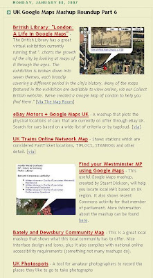
Google Maps Mania does a 6th Roundup on UK Based Mashups

Google Maps Mania UK Roundup Part 6
Image: Google Maps Mania

Some of the highlighted posts have more information on the mapperz blog.

Like
BlockHunter
Bristol Live,Work & Play
London: Life in Maps

and a few others not listed
Golf Course Finding Map
Zoomf Property Map (update)
Care Homes Map


Mapperz

Labels: , , ,

08 January 2007

Drive More Traffic to Your Maps API Site - Include KML Files

From the Offical Maps API Blog

)

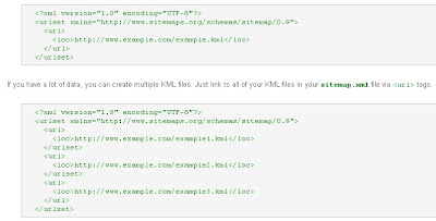
Publishing a KML Sitemap involves a few easy steps:

  • Identify those features on your maps site which can be displayed as KML features.
  • Convert those features into KML equivalents and publish them within one or more KML files.
  • Create a sitemap.xml file that identifies links to all of your KML files.
  • Place the sitemap.xml in the root directory of your site.
More Information here

A simple sitemap.xml example

Sitemap XML Examples
Note:Sitemap.xml files must have no more than 50,000 URLs
and must not be larger than
10MB

Mapperz RSS Feed

Mapperz

Labels: , , ,

Golf Course Finding Map

Golf Course Finding Map

Golf Course Finding Map

But with some clever integration
  • Search 10,20 or 50 Mile Radiuses
  • Dynamic Pan (Auto updates finding new courses in the radius range)
  • Dynamic Overview Pan as above but the overview map syncronized with the main map
  • Interactive Sidebar
  • Hotels Listed
Very fast retrieval of Markers and a well thought out map.
Well done The Golf-Finder.net Team

Full instructions on use

Labels: , , ,

07 January 2007

Google Earth Beta 4 Updates

Update via Ogle Earth

  • US Congress information has been updated to reflect the 110th Congress (Senators and Representatives) who took office on January 4th.
  • Updated content from the GeoWeb layer data sources (example, more than double the number of Panoramio photos)
  • Updates to other data layers (Volcanoes, ESA images, Tracks4Africa, etc.)
  • Updates to GEC [Google Earth Community] content to capture latest posts there.
    ...and as always, lots of subtle changes to refine both client at data.


  • The Overview Map - View> Overview Map (Ctrl +M)
  • New Layers and Content - Yelp Reviews, 3D Buildings (from 3D Warehouse), Roads of Brazil, Geographic Web (more Panoramio photos) and Sunrise Earth
Google Earth New Buildings Textures

Seems the big upadates are available with Google Earth 4 beta this allows to view higher quality 3D Buildings - many of which are photo-textured. Mapperz recommends that you install Google Earth 4 beta (build 4.0.2722) because it loads these models faster than the previous releases.

Source and more details: Google Earth Blog

Labels: , , , ,

05 January 2007

Mapperz joins GIS WIKI


Mapperz joins GIS WIKI

This Blog will be available through NewsFeeds

Labels: , , , ,

ArcGIS Explorer 9.2 Gets Fixed

ArcGIS Explorer 9.2 (Build 350) Gets Fixed

Fixed Features

Source: Spatial Adjusted

Note:You will need to Register to Download this Software

ArcGIS Explorer 9.2 (Build 350) is 28.4 MB in file size.

ArcGIS 9.2 Explorer Versions
Version 1.0.348 to 9.2.350

Labels: , , , ,

Zoomf Property Search - Update

Update from 19th August 2006
Zoomf Property Search Enhancements

New Features:
Zoomf.com have launched a new innovative feature on their website which allows users to find the average house price and other property statistical information for the different London boroughs. This information is processed completely live as normally obtaining this information can take weeks if requested from a real estate agent.


What is zoomf.com?

Zoomf.com is a residential property search engine connecting consumers with estate agents and property brokers. In one search zoomf.com enables consumers to find many 'for sale' and 'to let' property listings from a wide range of available Internet sources - and we continue to add new websites every day. Once the consumer finds a suitable property they are referred to the original source of the listing.

With a simple to navigate interface and map based presentation, zoomf.com makes it easy to drill down by property attributes, types and location to find the ideal home for you. You can either search for property by submitting your requirements or
browse for property by area.

Example

Posted by Mapperz

Labels: , , , , ,

Map Letter Gets Delivered

Map Letter to Cornwall


"I haven't got his address and he hasn't got my address either - we still haven't sorted that out"

"I drew a map of the coastline of north Cornwall and Devon and put on it 'Peter O'Leary, living somewhere here."


Source: BBC News
Alternative Source: Map Room
(Thanks to mapgirl)

Labels: , , ,

04 January 2007

Crown Copyright crushing UK Mapping Innovations

This is a post to make people aware that government agencies are stifling UK innovations.


"Public money paid for it - but the public can’t view because of crown copyright"

Says the Guardians Free Our Data Campaign

"Imagine flying at rooftop height up the Thames. You dive under Tower Bridge, then twist between the Gherkin and Tower 42 skyscrapers. As the London Eye looms, you bank right and dive into a translucent globe which transports you into the middle of St Paul's cathedral."


But you can't put it online!

"Although Virtual London was funded by another state body, the computer model cannot be posted on the web without infringing Ordnance Survey's copyright."

"Public money funds it, yet "public" copyright keeps it shut away."

But how can Geographically data be locked down to some ceramic hard drive and not accessible to the people who paid for it?

Nicely timed just ahead of Christmas, the Department for Constitutional Affairs has put its Statute Law Database online. You can search for any extant law, and various others - including how upcoming legislation will affect existing laws.
This was protected under crown copyright so why can this be released to the public free of charge and available online?

Come on Ordnance Survey sort your out of date crown copyright.
Reduce your prices to commercial vender's and you will gain more consumers and increase your incomes 10 fold.

Sources:
http://freeourdata.org.uk/blog/
http://technology.guardian.co.uk/weekly/story/0,,1981821,00.html
http://www.ordnancesurvey.co.uk/oswebsite/aboutus/
yourinforights/copyright/index.html

Even little company Google are having issues with Ordnance Survey -

"The sticking point is understood to be Google's attempt to negotiate a fixed fee for the data, rather than accepting Ordnance Survey's practice of charging by the number of transactions. Ordnance Survey would not comment on the specific case, but said that a fixed fee would "wreck the level playing field for other partners" - and it should be noted that it is obliged to treat all customers (including itself) on the same terms. OS said it is happy for its data to be used in a "Google-type" environment. "Sites such as Multimap and Streetmap use our data and their services are freely available to the public over the web.""

Labels: , , , , ,

BlockHunter - For Homeowners and Buyers

This site helps homeowners and potential buyers locate property for exchange.

Blockhunter Property Mapping

However there is major difference on this site

There are no properties for sale on this site.

Normally, you use an estate agent to advertise your house for sale

You hope someone sees your advert and buys your house

Blockhunter works the other way around

Buyers use this site to register their searches on a map

Sellers can then register their house to see if buyers are interested

Registered sellers are NOT advertising their property

Your property details remain private. It's up to you if you contact a buyer

The Mapping used the Google Maps API but there some nice functionality on the mapping side .
The Create Block refers to a rectangle that can be resized to become the search area.
This is a good way to empower the user and making the the search more interactive.

One Suggestion is to have a Circle Search and/or a multi-edged polygon.
Multi-edge Polygon Example
Circle Method

Has very good potential though. Mapperz

Labels: , , ,

03 January 2007

Google Maps and Topology

Quick update:
clickable circle with topology
creating your own circle on the fly with the inside/outside topology result.

Google Maps and Topology

Mapperz stumbled across this on the Mike Williams Website

Though he might or might not realise that this is simple Topology in effect.

Google Maps Polygon - Simple Topology
Link to live page

What is Topology?

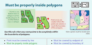
In GIS Terms it is "a spatial relationship between features" a set of rules that control features and errors between feature classes.

There can be many terms of this topology. A very simple example is a Point Feature has to be either Inside(1) or Outside (0) a Polygon Feature(s).

Point Topology Example
Image from Richie Carmichael (ESRI Prototype Labs)

To view this in Action modified slightly from Mikes code.

Why the fuss?
Using this type of analysis in google maps api can be applied and bringing the google mapping api into a very simple GIS.

In this Markers (or Icons) can be selected and stored as a collection of arrays.

This could be 'select ice cream vans (points) with the county of somerset (polygon) only.'
or
'select available houses to rent in the Royal Borough of Richmond-upon-Thames'


Geographic Information System (GIS). An organized collection of computer hardware, software, geographic data, and personnel designed to efficiently capture, store, update, manipulate, analyze, and display all forms of geographically referenced information.
www.fws.gov/data/IMADS/glossary.htm


Topology can be very powerful and very complex - this post only caters in the most primitive format of Topology.

Labels: , , , , ,