->

05 April 2010

OSM compare with OS Opendata Meridian2

OSM compare with OS Opendata Meridian2

update3:

Also Openlylocal is using the OS Opendata Postcodes
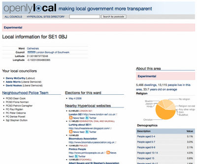
Openlylocal.com

http://countculture.wordpress.com/2010/04/06/new-feature-search-for-information-by-postcode/

update2 : Geocode Great Britain Postcodes >> http://www.uk-postcodes.com/ (not Northern Ireland) in HTML, XML, CSV, JSON or RDF formats. [now improved]

update at bottom: OS Streetview(10k rasters) with OSM in WGS84 (latitude, longitude like google,bing multimap maps)

View OpenStreetMap tiles and the new Ordnance Survey OpenData Meridian 2 tiles.
(but go with Meridian2 now or wait for VectorMap District next month?)

OSM compare with OS Opendata Meridian2
Redruth could be improved with the import of Meridian2 data - but is it worth waiting for the New OS Dataset 'VectorMap District' due in May 2010?

Meridian 2 Scale
"
The product is typically viewed at 1:50,000 and at this scale the generalisation of its features maintain geometric integrity and accuracy."


OSM compare with OpenData Meridian2

Traditional Open Street Map tiles can Meridian 2 help improve the more rural areas with many missing roads?

Compare the maps yourself woth the slider in the top left corner.
http://gibin.geog.ucl.ac.uk/~ollie/osopendata/meridian/?zoom=14&lat=50.23598&lon=-5.2233&layers=BT

[Very helpful and quickly set up]


May2010 - sample data is now available for
Bath (SP76) & Milton Keynes (SP83)
VectorMap District format and scale
Raster (lzw tiff)
Nominal scale is 1:25 000.

Recommended scale range is 1:20 000 to 1:30 000.

Vector (ESRI Shapefile)
Nominal scale is 1:25 000.
Recommended scale range is 1:15 000 to 1:30 000.


"
Coming soon – mid-scale customisable mapping

May 2010 will see the launch of OS VectorMap District, a customisable map that you can style to meet your own specific needs. What's more it will be available to use as part of the OS OpenData initiative!

OS VectorMap District provides a backdrop against which other datasets, together with your own information, can be overlaid. OS VectorMap District provides a great combination of high-quality data with the freedom to show the content you want, in the way you want to show it.

OS VectorMap District will be available in both raster and vector formats, so you can use it “out of the box”, or customise the look and feel to meet your specific needs. The vector format is supplied as points, lines, polygons and text, and includes 35 different types of feature code. This allows you to select and style different features in different ways."

More details

http://oliverobrien.co.uk/2010/04/accuracy-vs-completeness-osm-vs-meridian/

Ordnance Survey Streetview (Rasters) with Open Street Map

Ordnance Survey Streetview (Rasters) with Open Street Map (Development)

http://edgemaster.dev.openstreetmap.org/streetview_tiles/ossv.html?zoom=15&lat=51.75539&lon=-1.2401&layers=BTF


Labels: , , , , , ,

11 October 2007

Compare OpenStreetMap vs Google Maps Data Sources

An Update:Topologically Integrated Geographic Encoding and Referencing TIGER Data going into OpenSteetMap -
http://www.linux.com/feature/119493
  • with experience with TIGER data, towns and cities have fairly good data, though in more rural locations the data is of less (made up in some places) quality.
  • 'paper roads' can exist - where the roads have been planned but don't physically exist.
  • Poor positional accuracy has however made it extremely difficult to integrate TIGER with advanced technologies and data sources such as GPS, high resolution imagery.
  • The positional accuracy of TIGER road centerline can be improved from an original 100 plus meters using a method called 'conflation'(See Cartography)
Stats on the loading http://dev.openstreetmap.org/~daveh/tiger/stats.html

current stats
"We are processing 6.212597 OSM objects per second at this rate of upload, the entire US will be done in: 27401872 seconds or 317 days or 0.868313 years on Sun Aug 24 12:27:57 2008"


OpenStreetMap vs Google Maps Data Sources - who do you trust?

This is a very interesting topic and compares commercial products (TeleAtlas) with community captured data (OpenStreetMap)

Note: All Maps are to an extent wrong/or out of date, but having a good baseline of cleaned digital data is a very good start.

RefNum has produced set of 'editorial' markups showing the differences and even for a small town there are a number of striking ones.
Haywards Heath Errors - KML Overlay
In detail on Hayward's Heath is a KML Overlay highlighting errors.


Comparing TeleAtlas Google Maps with Open Street Map
geo.topf.org
has side by side comparison of Google Maps and Open Street Map (MapNik Styled)

"This is an attempt at generating nice map tiles for slippy maps at low zoom levels which can then be combined with OpenStreetMap tiles from higher zoom levels.
The information in the OpenStreetMap database is intended for higher
zoom level and doesn't work well when viewing the whole world or a whole continent."
Jochen Topf
http://geo.topf.org/contact.html

So the future looks good for community based mapping data (open source free mapping).
Commercial digital data capture companies have the edge for coverage at the moment. But the more the people and small companies that join in the faster the benefit to all.
It will not put out business to business mapping but for 'Joe Public'
without the threat of breaking licencing infringements to produce maps for personal/club/internet usage.

Interested in this Project?
Then head to OpenStreetMap


Source:
http://www.opengeodata.org/

Mapperz

Labels: , , , , , ,

01 July 2007

iPhone or N95?

Okay in simple terms why Mapperz bought an N95 and not an iPhone.

The iPhone has:
  • Touch Screen (3.5-inch (diagonal) widescreen multi-touch display))
  • Auto rotate
  • Maps (Google)
  • Quad Band (850, 900, 1800, 1900 MHz)
  • Wifi -Wi-Fi (802.11b/g) no n?
  • 2 Mega-pixel camera (my 5 year old camera has 3mega-pixel)
  • Limited Software available
  • A Polishing Cloth.
iPhone with Map no GPS!
Image:geothought.blogspot.com

Though it lacks one fundamental feature. GPS

If your going to have mapping on your phone, you want to know where you are, not Steve Jobs Office Location.

Just this one missing feature stops Mapperz pursuing the iPhone.

Location based information is useless unless it is providing information around your position or desired destination.

Now if Nokia and Apple produced a product together then it would be a better solution. But this is unlikely.

The N95 has done and is still doing it's job, however the information that phone has in its needs to be updated and cleaned. It is only a computer and can only give you the information it has.
(more map updates from TeleAtlas needed)

N95 has
  • GPS - Locates you in a few seconds (faster in the car with 12v of power)
  • Built in Maps - if you pre-load onto your memory card.
  • Built in Sat Nav with voice commands (if purchased)
  • 5 Mega-pixel camera.
  • Lots of supported software available.
N95 Maps GPS Active
Image:Allaboutsymbian.com

Mapperz own views, comment if you like.

Labels: , , , ,

05 January 2007

Zoomf Property Search - Update

Update from 19th August 2006
Zoomf Property Search Enhancements

New Features:
Zoomf.com have launched a new innovative feature on their website which allows users to find the average house price and other property statistical information for the different London boroughs. This information is processed completely live as normally obtaining this information can take weeks if requested from a real estate agent.


What is zoomf.com?

Zoomf.com is a residential property search engine connecting consumers with estate agents and property brokers. In one search zoomf.com enables consumers to find many 'for sale' and 'to let' property listings from a wide range of available Internet sources - and we continue to add new websites every day. Once the consumer finds a suitable property they are referred to the original source of the listing.

With a simple to navigate interface and map based presentation, zoomf.com makes it easy to drill down by property attributes, types and location to find the ideal home for you. You can either search for property by submitting your requirements or
browse for property by area.

Example

Posted by Mapperz

Labels: , , , , ,

31 October 2006

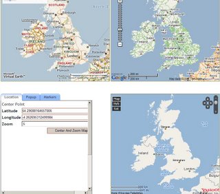
Compare Microsoft, Yahoo and Google Maps

Compare Microsoft, Yahoo and Google Maps on one Webpage

"Map Compare allows you to evaulate which mapping technologies is best. All three maps are locked together so panning, zooming and changing map types will effect all maps the same. You can also use the tab pane to try out various map features like; markers, popups as well. "

Compare Virtual Earth, Google, Yahoo Maps

Best Maps - Google (Carographically)
Best Aerial/Satellite - Virtual Earth (Higher Resolution more UK coverage)
Best Geocoder - Yahoo (percentage match returned but Live Local does Geocode UK addresses)

So a Mashup of Google Maps, Virtual Earth Aerial view and Yahoo Geocoding would be the ideal solution.

Nearest found is Flash Earth where is it easy to switch layers between mapping sources.
Does not support geocoding as yet.

Labels: , , , ,