->

31 August 2007

Picasa Mapplet Search - Google MyMaps

Picasa Mapplet Search - Google MyMaps New!

Allows users to Search for Geotagged photographs that have been made publicly available via the Picasa Web Albums

Picasa Mapplet Search - Geotagged Photos in MyMaps

Other Picasa enhancements
  • The size of the images you can upload - from 10MB to 20MB per image.
  • Upped the free storage quota to 1GB (and counting!)
  • All photos uploaded through Blogger now appear in My Photos
  • Mac Version of "Picasa Web Album Uploader"
Get Geotagging your photos and share where you have been.

Official Post


Mapperz

Labels: , , , , , ,

29 August 2007

Ovi Nokia Maps Released

Ovi Nokia Maps Released for All - (Out of Beta!)

Nokia Maps Released

"London, UK – Nokia today introduced Ovi, the company’s new Internet services brand name. With the
introduction of Ovi, Nokia is expanding from a focus on mobile devices to offering a range of Internet services. Ovi, meaning ‘door’ in Finnish, enables consumers to easily access their existing social network, communities and content, as well as acting as a gateway to Nokia services."

Ovi Nokia consists of:
  • Nokia Music Store
  • N-Gage
  • Nokia Maps
  • *(more to be added)

Also under the Ovi umbrella is Nokia Maps, a navigation service that offers maps, city guides and more directly to compatible mobile devices. Nokia aims to bring more Internet based services to Ovi in the coming months.

Give me the links!

http://europe.nokia.com/A4509271 - Nokia Maps/Device Selector

http://europe.nokia.com/A4509291 - Introduction and how it works

http://ovi.nokia.com/ovi/flash/assets/

pdf/1_MeetOvi_Umbrella.pdf - Press Release (PDF)

http://nds1.nokia.com/files/support/global/phones/
guides/Maps_1_UG_en.pdf
User Guide (PDF)

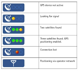
Nokia Maps GPS Fixes
GPS Fixes - the bottom icon costs you money with data transfer - Assisted GPS enabled (N95) only

Mapperz

Labels: , , , , , ,

Flash Earth inside Google Earth

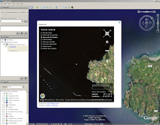
Flash Earth inside Google Earth

The amazing Flash Earth is a great application on itself.

Now combined it with the Desktop Google Earth (4.2)

and it becomes a very useful and powerful resource for users to compare areas where imagery and digital coverage is 'blurred'.

Layers available in Flash Earth are
  • Google Maps
  • Microsoft Virtual Earth (VE) Aerial
  • Microsoft Virtual Earth (VE) Labels
  • Yahoo Maps
  • Ask Maps
  • Ask Aerial
  • Open Layers
  • NASA Terra (Daily)
*NASA shows the smoke from the fires that have swept across Greece (BBC News Link)

Flash Earth inside Google Earth

Even Google Earth Rotation is maintained when the Flash Earth is activated inside Google Earth.

"What if the current view in Google Earth was quickly viewable in other maps, such as those made accessible by FlashEarth? Well, now it is. As you move around the globe a little white arrow follows you around, simple click it to get an approximation of the current view in FlashEarth in a popup balloon."


Total credit to Valery35, for the concept (including a screenshot) on the Google Earth Community and to all the people made all the bits that could be pieced together in this 15min hack.

Google/Flash Earth Network Link by Barry Hunter Nearby.co.uk

The Original Flash Earth http://www.flashearth.com/


Labels: , , , ,

28 August 2007

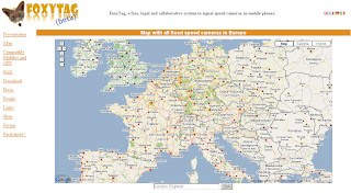
FoxyTag - Speed Camera Locations Map

FoxyTag - Speed Camera Locations Map

Links speed cameras to map locations to mobile device

Speed Camera Locations Map

FoxyTag signals fixed and mobile speed cameras, data is updated every 5 minutes, the system works worldwide and is free.

Where does the data come from?
"FoxyTag is entirely collaborative (it is the users that post tags) and does not require any central operator to filter and validate data (it is done automatically). FoxyTag is a testing lab for future technologies and its main capital is its number of users."

more info

mapperz

Labels: , , , , , ,

24 August 2007

Statris - Map Game

Friday Fun - Map Game Stratris

Like Tetris but with geographical regions as blocks and your knowledge of these different regions.


Africa

Europe

France

Netherlands

USA

UK

Tip - Start of easy and be fast with the cursor arrow keys!

*Based in Flash

Thanks to Raymond Penners

Labels: , , , , , , ,

23 August 2007

SatMap - A Sports GPS

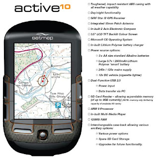
SatMap - A Sports GPS called the 'active10'

Sat Map Sports GPS

Source: © Satmap Systems Ltd

Specifically built for the UK Market. So it's waterproof!

Contains Ordnance Survey Mapping (on SD Card)

Easy to use
No computer is needed, just insert a map (SD Card) and go.

Real maps select from the wide range of titles
containing high quality maps supported by Ordnance Survey.
1:50,000 and 1:25,000 Mapping

Clear navigation
The intelligence of the active10 makes finding your way simple.SatMap Sports GPS Features

Source: © Satmap Systems Ltd

Internet links
A simple USB cable is all you need to connect to the Internet to download maps or share your favourite routes.

18 different titles, each one giving you all the 1:25,000 EXPLORER and 1:50,000 LANDRANGER maps on the trail making sure you stay on track.

UK Regions
10 different titles, each showing over 20,000 km2 of the country on a 1:50,000
LANDRANGER map giving you the freedom to roam throughout your region.

UK Counties
67 different titles, each on a 1:50,000 LANDRANGER map, allowing you to
focus on your favourite county.

Electronic compass
An internal electronic compass that works just like a standard hand-held compass.

Trip statistics
Automatically records route data so you always know how you are doing.

Price £300

Looks good and sounds great but a few questions

Does is export to KML?
Battery life?
Can you add your own mapping?
If you don't need PC how do you connect to the internet to share maps? (Built in Wifi?)

Technical Specs (PDF)
http://www.satmap.com/eshot/Satmap_product.pdf

http://www.satmap.com/eshot/Satmap_Tech_Spec.pdf

Labels: , , , , , ,

22 August 2007

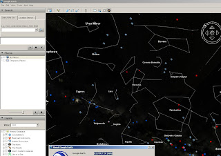
Google Sky Earth (inside Google Earth) New!

Update: As expected Ogle Earth does an excellent introduction to 'Google Earth 4.2'

One pointer that users should be aware is that it now supports KML 2.2 (beta)
http://code.google.com/apis/kml/documentation/kml_tags_beta1.html

now includes:
  • ExtendedData (replacement for metadata)
  • Atom feeds
  • AbstractView
  • ResourceMap
  • PhotoOverlay
  • Google Earth release 4.2, video is supported!
Official post on this http://google-latlong.blogspot.com/2007/08/sky-final-frontier.html

Google Sky is an addition to Google Earth New!

Google Sky Earth

You will need to download the newest version of Google Earth to use it.
version 4.2.0180.1134

http://earth.google.com/download-earth.html

More info
http://news.bbc.co.uk/1/hi/technology/6955787.stm

Works well so far - but only had 10 minutes...

Google Sky Button
The Google Sky button is here on the new version.

Labels: , , , , , ,

Satellite Finder Map - Updated

Update:
11/09/2007

Dishfinder (Global Coverage)

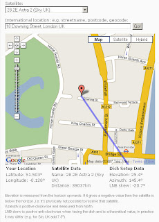
Satellite Finder Map

A nice and easy way to find Satellites to receive TV programmes.
now with Elevation, Azimuth, and LNB Skew New!

"For all DIY satellite enthusiasts and satellite installers this is a very useful and genuine "

Satellite Finder Map

Enter a valid address then the click Go!
A line and marker appear - the marker is draggable (use satellite/aerial mode to find the right location)
Sky is Default and there is a huge list of other satellites available.

Satellite List

Update 21.08.07: The elevation and LNB skew calculation results just underneath the map. These are calculated and displayed in real time as soon as you move the marker or change the satellite.

Find your satellite using the map

Mapperz

Labels: , , , ,

21 August 2007

Embed Google Maps in Your Website or Blog

Embed Google Maps in Your Website

No API key needed just copy and paste... by using the link to page on google maps,

Embed Google Maps Link
Select, Copy and Paste the HTML snippet to your website

"Today we're excited to announce a new feature on Google Maps that allows you to add maps to your blog or website just by copying and pasting a snippet of HTML. And once you embed the map, it has all the same functionality of the Google Maps you know and love; it's clickable, draggable, and zoomable."
Jess Lee, Product Manager, Google Maps

It's as easy and simple to use (like embedding a YouTube Video)

So you can make your maps and post them out there and make more widely available.

Mapperz thinks this is a good move by Google


View Larger Map


More Examples over at the Official LatLong Blog

Labels: , , , ,

20 August 2007

Hurricane Dean - Mapped and Tracked

Final Update:
The storm has reached Category Five, the highest strength, with winds of up to 160mph (255km/h).

Dean Hurricane at Category 5
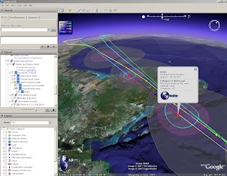
Radial Zones show destructive path of Hurricane Dean at Category 5

For a Visual Understanding - view the Hurricane Animated guide from the BBC (in Flash)


Update 3:
Dean is now forecast to slam into Belize and the east coast of Mexico's Yucatan Peninsula, including the popular tourist destination of Cancun.
http://news.sky.com/skynews/article/0,,30200-1280456,00.html?f=rss

Update 2:
meteorological reports the storm could intensify into a Category Five hurricane in the next few hours.
http://news.bbc.co.uk/1/hi/world/americas/6954296.stm

"
Dean is now expected to pass close by the low-lying Cayman Islands, before hitting Mexico in the coming hours"


Update:
For more information
http://www.nhc.noaa.gov/#DEAN

Currently Category 4
"Winds 131-155 mph (114-135 kt or 210-249 km/hr). Storm surge generally 13-18 ft above normal. More extensive curtain wall failures with some complete roof structure failures on small residences. Shrubs, trees, and all signs are blown down."
There is potential for this hurricane to be upgraded to category 5...eek!
" Dean is now over very warm water and in an ideal situation to strengthen further."
Rob McElwee, BBC Weather


Hurricane Dean - Mapped and Tracked

Hurricane Dean Tracked

View live updated content for Hurricane Dean with predicted courses based on category (currently 4).

The KMZ for Google earth comes with more information.
  • Oil and Gas Fields
  • Buoys (Windspeed, pressure etc)
  • Sea Temperatures (very important with hurricanes)
  • Clouds (Shows the scale of the hurricane)
  • Predicted Routes/Modeled Forecasts

more information from GraphOilogy Blog

Link to the KMZ (the latest release of Google Earth is required which is 4.1.1087.5048)

Labels: , , , , , ,

17 August 2007

Exclusive - Reverse Geocoding using Google Maps API only!

Exclusive - ALL New! Reverse Geocoding using Google Maps API only!

Google Maps is great! and the programmers that take the API and do find and create useful applications. Like this Reverse Geocoding

What is reverse geocoding?
"The conversion of latitude and longitude coordinate data of locations into descriptive addresses"

Reverse Geocoding UK Addresses

Try it out here
http://nicogoeminne.googlepages.com/reversegeocode.html

Thanks to Nico Goeminne for finding this algorithm and giving Mapperz the chance to suggest and give exclusive feedback on this incredible function.

Is this legal? - Yes, We have had this confirmed by Pamela Fox (Google Maps API Team) that this is not breaking the Terms of Use - which is great news.

"I checked with a product manager and he looked through our licensing
agreements. The conclusion is that as long as you're not using the
reverse geocoder for real-time tracking of any kind, then you're okay
to use it."

Please use it - suggest comments, feedback always welcome.

Nico's idea came from this
"Google Maps is great! One day I was working on a treasure hunting game, it combined both real world as virtual items placed in and around the very nice city of Ghent (Belgium). At regular times I told them the location (GPS) of an item, so they could go out hunt. Some of them complained because they didn't have a GPS and couldn't find an online tool to convert the GPS coordinates to an address. "No problem I said, I'll fix one up", at that time I did not cross my mind that GM couldn't reverse geocode since before all things I ever needed were just there in that great API. So I was kinda disappointed when I read trough the documentation and even more when I searched the net on the subject. So in the end, I decided to give a try myself and see if I could figure out something and then I stroke me : The GM API has reverse geocoding capabilities. They just call it Driving Directions! Google Maps is great! "

Thanks and all credit to Nico - Excellent Job!

Mapperz Tests a UK version of this method (demo)

Labels: , , , , , , , ,

16 August 2007

New UK Address Geocoder with Sidebar - Google Maps API

UK Geocoder with Sidebar - using Google Maps API


Expanding on the Local Search Geocoder, using the Google AJAX Search API

Please use the Official Example:
http://gmaps-samples.googlecode.com/svn/trunk/geocoder/singlegeocode.html

This New! version use the Google Maps API (based on ESA's orginal code in version 2.55 of the API)

Now that Google Maps API supports UK Geocoding this can be done! (UK Geocoding accuracy has decrease now)

UK Address Geocoder with Clickable Sidebar
Enter a UK Address
Click 'Search'
10 results max are returned
Click on the address to zoom to that location
if you want to click on the marker and select 'copy to memo area'
This stores as many geocoded addresses as you want and then can be copied out to spreadsheet.
This could be then imported to a GIS using the latitude and longitude

Credit to Esa

*Note on the accuracy on the geocoded addresses, it can be up to 150 metres out in any direction.

Labels: , , , , ,

15 August 2007

ArcGIS Explorer - Build 410 Released

ArcGIS Explorer Build 410

Improvements - it's smoother

Result Properties
source: ESRI

* When a result is generated it has a default zoom extent, or view. The default view is from an overhead perspective. You can capture a new view by moving and/or tilting to a new perspective, then using the result property sheet to capture the new view. The view property is persisted with the result.

Navigation with ArcGIS Explorer has been enhanced in the following ways.

Observer Elevator Movement: By default, zooming in and out on the map using the mouse or keyboard will zoom relative to the target location. Holding down the Ctrl-key and using the + and – keys will change the observer elevation. This is similar to traveling up and down in an elevator. This type of movement is useful for viewing vertical features in your map at differing elevations.

Zooming to Cursor Position: Zooming to a location on the map has been enhanced by zooming to the mouse pointer position. You can still zoom to the center of the map by holding down the Ctrl-key while scrolling the mouse wheel. Zooming out always occurs from the center of the map.

Look Replaces Pan at Tilt Angles Larger Than 45 Degrees: In previous versions of ArcGIS Explorer, double clicking on the map when viewing the map tilted beyond 45 degrees would center the clicked location. This often changed the distance from the observer location to the target. Now when the map is tilted beyond 45 degrees, a double-click will use the Look functionality, changing the observer's view without changing the observer position.


* Subsurface Navigation
To get a subsurface view of the earth, tilt your map then hold down the Ctrl key and use the + or - keys to move straight down below the earth or to move straight up.


* Easier Navigator Access
Access to the Navigator is easier; the target area which maximizes the control has been made larger.


* Faster Opening of Server Folders
The performance of opening servers publishing services in multiple sub-folders has been improved.


* Improved Stars
Stars now appear as different sizes and are centered at the observer position to illustrate their correct location, providing a more realistic appearance for the sky and globe.


* Close Shortcut
The keyboard shortcut which closes the application is now Alt-F4 to adhere to standard shortcut conventions.

* Point measurements and point notes now store the view properties captured at the time of their creation. For example, when you add a point note the current view will be captured and stored with the note. You can double-click the note to zoom to the specified view. The view properties can be edited through the result property sheet


* New Find Address task replaces the previous Find Address task found in earlier builds. The new task provides the capabilities to enter address or place in a single input from which it will be parsed and matched.

The Find Route and Get Driving Directions tasks provide a convenient drop down menu allowing you to choose which language to display your directions and routes. The following languages are supported: Danish, Dutch, English, French, German, Italian, Norwegian, Portuguese, Spanish, and Swedish

Free Download
http://services.arcgisonline.com/410/explorer/software/downloadpage.html
(No login required)

Labels: , , , ,

13 August 2007

Live Derby 2007 - Microsoft Live Maps Game

Live Deby 2007 - Microsoft Live Maps Game
5 cities to choose from
  • New York
  • London
  • San Francisco
  • Seattle
  • Las Vegas.
Microsoft Live Derby 2007 - Game

Using Microsoft Live Maps

Play Microsoft Live Derby 2007

Labels: , , ,

Map Seeaarch - but who wins?

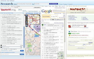
Seeaarch is a quick fire, map and directions search website that uses 4 mapping solutions

Map Searches
  • Yahoo
  • Google
  • Live
Directions
  • Yahoo
  • Google
  • Mapquest
Though a quick test reveals a clear winner.

Seeaarch Results - Winner
note: moving the columns is possible to show each one more clearly.

Yahoo gets confused but tries (finds an American route)
Google does the job - as you would expect
Mapquest failed to find the start location

Mapperz requests directions from
10 Downing St, Westminister, London, UK
to SW19 1AR (Wimbledon)

So there a quick and effective test.
(So why not just use Google Directions?)

When Planning a route, whether it is in the UK, Europe or any other part of the world, don't just rely on one solution.
The AA Travel Planner is more effective than any of the above in the UK. The driving times are more accurate and the congestion travel information is more up-to-date.
For Europe try Yahoo Maps

Labels: , , , , , , , , ,

10 August 2007

Yahoo Pipes - News Map - Output KML

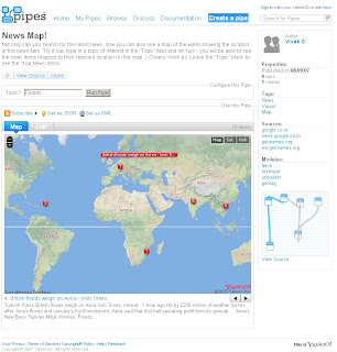
Yahoo Pipes - News Map
Finally a Yahoo Pipe that uses a map to visualize the found results.

Yahoo Pipe Map - Author Vivek C

Author of the Pipe is Vivek C

Though there were not many feeds to the Map - The useful thing with Yahoo Pipes is that when it is published it is available to public and 'Copies of' can be created (sign in to yahoo required).

Here is Mapperz version of this
Yahoo Pipe Map Mapperz Version
This Map is overlaying rss feed from the yahoo pipe model below
Yahoo Pipe Map Model - Mapperz Version

Add RSS feeds is very easy to apply - use the + icon on the url feed.
Mapperz added some extra rss feeds
BBC News
Reuters UK
Sky News
CNN
and the Mapperz Blog


But the clever thing about this pipe is that it is using a normal rss feed then using geonames.org to apply a latitude and longitude to the rss feed > therefore creating a georss feed. This is then overlayed on a yahoo map showing the locations around the world.

Yahoo Pipe Map KML - Google Earth
One final point, you can export the results to KML and view in 3D using Google Earth.
One helpful scenario would be if you were looking for a new house and you can request different estate agents and overlay and view the surrounding area.

Labels: , , , , , ,

09 August 2007

Open Street Map - Cycle Map

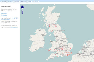
Open Street Map - Cycle Map

Open Street Map - Cycle Map
A nice implementation 'in progress' using free data. A positive move to community based mapping and you can see the results from this map.

The Cycle Map is based on data from the openstreetmap project. At low zoom levels it is intended for overviews of the national cycle network; at higher zoom levels it should help with planning which streets to cycle on.
Key:

  • Routes in red are national cycle routes.
  • Routes in blue are local cycle routes.
  • Cycleways are shown in green and yellow.
  • Toucan crossings are shown as green circles.

An up and coming event for UK Cartographers
Society of Cartographers - 43rd Annual Summer School 3rd - 6th September 2007
http://www.port.ac.uk/special/soc/

Programme Details are available from
http://www.port.ac.uk/special/soc/programme/

The 'Learning Technologist' Richard Treves interviews the Chairman of SOC has a blog called
http://googleearthdesign.blogspot.com


Labels: , , ,

07 August 2007

More Google StreetView Cities Mapped

More Google StreetView Cities Mapped

more street view cities mapped
  • Orlando, (including Daytona Beach, Miami)
  • Los Angeles (including Long Beach, Anaheim)
  • San Diego (including La Mesa, Escondido,Chula Vista)
  • Houston (including Webster, Galveston, Texas City)
more street view cities added - Orlando
Orlando


more street view cities added - Los_Angeles
Los Angeles


What is Street View? (Embedded Video)

Official Post from the Google Lat/Long Blog

UK to be next?

Mapperz

Labels: , , , , , , , ,

Foot and Mouth Map - Surrey

Update - a second outbreak confirmed (11am BST 07/08/07)

A Second Outbreak Foot and Mouth Map
More info on the Defra and BBC News pages

Foot and Mouth Map - Surrey (UK)


"Following an investigation of suspected vesicular disease by Animal Health on a holding near Guildford in Surrey, laboratory results on Friday evening, 3 August indicated the presence of the Foot and Mouth Disease (FMD) virus in samples from cattle on the premises."
Source: Defra

here is the map (available as a pdf here)
Defra Foot and Mouth Map - Surrey UK

What is foot and mouth? (wiki)

The interactive version is now available.
http://www.gisdiseasemap.defra.gov.uk/intmaps/FMD/map.jsp
Defra Foot and Mouth Interactive Map - Surrey

More information on the BBC News Website

Mapperz

Labels: , , ,

06 August 2007

Mission accomplished - Long Way Down

Mission accomplished - The Long Way Down (there is a Map)

"Long Way Down is the most recent motorbike adventure with Ewan McGregor and Charley Boorman. Leaving on 12 May 2007, they travelled through Europe, and then Africa – from Tunisia to South Africa, via countries such as Egypt, Ethiopia, Kenya, Tanzania and Namibia - a total of 15,000 miles. The team arrived in Cape Town, South Africa on 4 August 2007. It is a follow-up to the Long Way Round trip in 2004, where the pair rode their motorbikes from London to New York, travelling east across Europe, Russia and the United States. As on Long Way Round, they were accompanied by Executive Producers/Directors Russ Malkin and David Alexanian."

BBC Long Way Down Map

http://www.bbc.co.uk/longwaydown/map.shtml

Well done!

Labels: , , , , ,

Major Infrastructure Development Map

Major Infrastructure Developments Map (UK)

The Map that shows the location of proposed major infrastructure developments (such as airports, tidal barrages, and nuclear power sites) that may be built following a proposed change to UK planning law.

"Good planning is essential for sustainable development and environmental protection. A coalition of the UK 's main environmental, conservation and civic organisations with currently over 5 million members came together out of a deep concern over many of the recommendations of the Barker Review of Land Use Planning. Having now been incorporated into the Government’s Planning White Paper, these recommendations would - if implemented in its current form - be a backwards step for the planning system"

Planning Disaster Map UK
Nice and clear icons show the user exactly what is going where.
Click on the icons to reveal more information about the planned development/re-development of sites.
See the Map

Other parties involved

Campaign to Protect Rural England Friends of the Earth The Wildlife Trusts The Ramblers RSPB Transport 2000 New Economics Foundation The Woodland Trust

Labels: , , , ,

02 August 2007

My Maps in your Blog

My Maps in your Blog

With clickable, points lines and polygons!


This demonstrates how easy it is to add Google 'My Maps' to your blog

This is the code at does it available from http://www.mymapsplus.com/


Click the small black arrow to close the legend to view the map in the post here.

*please note this a fictitious scenario for example purposes

Labels: , , , , , ,

Google Directions adds real Traffic Times

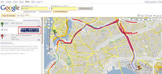
Google Maps Directions adds real Traffic/Journey Times

Google Maps directions plus traffic timesGoogle Maps directions plus adjusted traffic times
Very simple but very useful

Going to JFK to New York (Google's centre point for New York) or vice versa in this example - waiting 10 minutes between requests shows two different sets of traffic and therefore adjusts the approximate time for the journey.
Knowing the 'appendence' of each segment of line (road in this case) and the distance is therfore easy to work out the time it will take to cover that segment, join them up and you get an ETA of the journey.

Official Post from the Google Lat/Long Blog


Next transitional times - incorporating walking time, trains, train stops, buses, trams as well as Traffic?
Mapperz

Quick Note:
Geocoding Expands India, Hong Kong, Taiwan, Singapore, or Ireland (Via the MapRoom)
Official Post by Pamela Fox

Labels: , , , , ,

01 August 2007

ArcGIS 9.2 Service Pack 3 Released

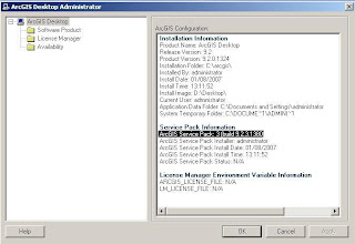
As promised by ESRI ArcGIS 9.2 Service Pack 3 is released on time.

ArcGIS Service Pack 3

ArcGIS 9.2 Service Packs for ArcGIS

  • ArcGISDesktop92sp3.msp -165 MB
  • ArcGISDesktopHelp92sp3.msp - 379 MB (mapperz recommends to use the web version at all times - as updated more frequently)

  • ArcGIS Desktop Developer Kit for the Microsoft .Net FrameworkDesktopSDKDNet92sp3.msp - 51 MB
  • ArcGIS Desktop Developer Kit for Visual Basic 6 (no updates since SP2)
  • DesktopSDKVB692sp2.msp - 1 MB
  • ArcGIS Desktop VBA Developer Resources (no updates since SP2)
  • DesktopSDKVBA92sp2.msp 1 MB
  • ArcGIS Desktop Developer Kit for Visual C++ (no updates since SP2)
  • DesktopSDKVCPP92sp2.msp - 75 MB
  • ArcReader ArcReader92sp3.msp - 57 MB
  • ArcView 9.2 Evaluation Edition - ArcGISEvalEdition92sp3.msp 165 MB
  • ArcGIS Tutorial Data Tutorial92sp3.msp - 4 MB

  • ArcGIS Engine Runtime ArcGISEngine92sp3.msp - 115 MB
  • ArcGIS Engine Developer Kit for the Microsoft .Net Framework
  • ArcGISEngineSDKNet92sp3.msp -51 MB

  • ArcGIS Engine Developer Kit for C++ (no updates since SP2)
  • ArcGISEngineSDKCPP92sp2.msp - 69 MB
  • ArcGIS Engine Developer Kit for the Java Platform (no updates since SP2)
  • ArcGISEngineSDKJava92sp2.msp - 1 MB
  • ArcGIS Engine Developer Kit for Visual Basic 6 (no updates since SP2)
  • ArcGISEngineSDKVB692sp2.msp - 1 MB
  • ArcGIS Engine Developer Kit for Visual C++ (no updates since SP2)
  • ArcGISEngineSDKVCPP92sp2.msp - 66 MB
  • ArcGIS Server for the Microsoft .Net Framework
  • ArcGISServerDotNet92sp3.msp - 273 MB
  • ArcGIS Server Web ADF Runtime for the Microsoft .Net Framework
  • ArcGISServerWebADFRuntime92sp3.msp - 20 MB
  • ArcGIS Server for the Java Platform
  • ArcGISServerJava92sp3.msp - 254 MB
To Download them go to the ESRI Download Area

Labels: , ,