->

13 February 2008

Spreadsheet Mapper 2.0

A Google tutorial shows you how to enter data in an on-line spreadsheet to generate a set of markers in Google Earth and Maps and Google Maps API. Google Docs' web-based, collaborative editing allows your team members to simultaneously enter data and instantly publish updates.

"Using this tool you could: showcase your organization's projects, program sites or partners; map your offices, volunteers, or resources; or visualize your data on local, regional or global scales."


Time to create Lines and Polygons...
Lines

Excel to KML (now with Line and Arrows from GPS track logs) http://www.earthpoint.us/ExcelToKml.aspx


Polygons

http://code.google.com/articles/support/ezdigitizer.htm
(copy and paste the code into excel or notepad and save as kml)

Official Link:

http://earth.google.com/outreach/tutorial_mapper.html

source: http://freegeographytools.com/

Labels: , , , , ,

02 August 2007

My Maps in your Blog

My Maps in your Blog

With clickable, points lines and polygons!


This demonstrates how easy it is to add Google 'My Maps' to your blog

This is the code at does it available from http://www.mymapsplus.com/


Click the small black arrow to close the legend to view the map in the post here.

*please note this a fictitious scenario for example purposes

Labels: , , , , , ,

03 January 2007

Google Maps and Topology

Quick update:
clickable circle with topology
creating your own circle on the fly with the inside/outside topology result.

Google Maps and Topology

Mapperz stumbled across this on the Mike Williams Website

Though he might or might not realise that this is simple Topology in effect.

Google Maps Polygon - Simple Topology
Link to live page

What is Topology?

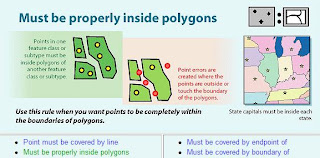
In GIS Terms it is "a spatial relationship between features" a set of rules that control features and errors between feature classes.

There can be many terms of this topology. A very simple example is a Point Feature has to be either Inside(1) or Outside (0) a Polygon Feature(s).

Point Topology Example
Image from Richie Carmichael (ESRI Prototype Labs)

To view this in Action modified slightly from Mikes code.

Why the fuss?
Using this type of analysis in google maps api can be applied and bringing the google mapping api into a very simple GIS.

In this Markers (or Icons) can be selected and stored as a collection of arrays.

This could be 'select ice cream vans (points) with the county of somerset (polygon) only.'
or
'select available houses to rent in the Royal Borough of Richmond-upon-Thames'


Geographic Information System (GIS). An organized collection of computer hardware, software, geographic data, and personnel designed to efficiently capture, store, update, manipulate, analyze, and display all forms of geographically referenced information.
www.fws.gov/data/IMADS/glossary.htm


Topology can be very powerful and very complex - this post only caters in the most primitive format of Topology.

Labels: , , , , ,