->

16 December 2010

OS OpenSpace & Google Maps v3 Meet

OS OpenSpace & Google Maps v3 Meet

Another great example from Bill Chadwick

OS OpenSpace & Google Maps v3 Meet
Merging Map Tiles Ordnance Survey and Google Maps based on v3 Google Map API

"The demo code provides a Google APIV3 Custom Map Type for OS OpenSpace tiles. There is no reason why the same approach can not be used to warp tile sets from other, non Google projection tile servers. The basic affine transform technique could also be used to provide an OS OpenSpace Custom Overlay for Google Maps. This might use less DOM nodes but would not easily support the hidden peripheral tile fetching of the Custom Map Type.

The demo code uses the WGS84 Lat/Lon to OS East/North coordinate conversion from OSGB Web Map Tools and the Ground Control Point to Affine Transfrom Matrix algorithm from Google Mapping Hacks. The coordinate conversion accuracy is 1-2m across the UK, consistent with the 1m pixels used by the most zoomed in OS mapping. Whilst the OS OpenSpace tile server uses WMS like URLs, I do not believe that it will return Google projection tiles.

The demo only works in SVG enabled browsers. I have tried it in Firefox 3.6, Safari 5.02, Opera 10.63 and Chrome 8.0.552.215 and Internet Explorer 9 beta. Chrome seems to be the fastest and gives the best visual results (invisible joins between OS tiles)."

Full credit to Bill Chadwick

View the Map

http://wtp2.appspot.com/warpdemo.htm

Labels: , , , ,

26 August 2010

Map Channels - Location Maps

Map Channels - Location Maps
*Using Google Maps API v3

Location Maps are simple controls to display a map of a single location. Street View can optionally be shown with the map.

Location Maps use the
Google Maps v3 API and are provided free for commercial or non-commercial use.

No adverts are included in Location Maps. An 'embed' control links from the map to this page.


Control size, maptype, map controls, markers and more with the new Location Maps which utilizes the fast v3 of Google Maps API.

Technical Notes:

You may copy the embeddable Location Map HTML Page to your own website (change the url used within the embeddable HTML code).

• Location Maps use the new Google Maps v3 API. This is more compact so loads faster.
• No API Key is needed for the Google Maps v3 API.
• The Street View is displayed without using Flash so no browser plugins are required.
• The 'fullscreen view' option included with the v2 API is not available. To see a larger street view click on the Google logo to see the street view at maps.google.com.

Full API reference can be found here http://www.mapchannels.com/LocationMaps.aspx#api


Labels: , , , , , ,

29 June 2010

Happy Mappy 5th Birthday - Google Maps API

Happy Mappy 5th Birthday - Google Maps API

Google Maps API was released 5 years (today) ago and now there are 350,000 unique map 'mashups' truly amazing. Good luck to the next 5 years!

5th Happy Mappy Birthday - Google Map API
Keir Clarke - Google Maps Mania author created this 5th Birthday Google Map Mashup to display messages and map mashup - you can contribute by adding your message....

from the Official Post:
"Today is an important milestone here at Google and we’re all pretty excited - the Google Maps API turns 5! It was five years ago today that we posted a brief announcement to let the world know about the JavaScript Maps API and now 5 years later more than 350,000 active websites make use of it. Uses have ranged from tools that have made it easier to find an apartment, track the Gulf of Mexico oil spill and even make an Earth sandwich! Many, many more examples have been chronicled on sites like Mashable and the Google Maps Mania blog. In 2005, Adrian Holovaty launched the first crime mashup that overlaid Chicago’s public crime data onto online maps providing Chicago’s citizens and journalists with a true picture of crime in their city. The site won the 2005 Batten Award for Innovations in Journalism and was named by The New York Times as one of 2005's best ideas. In honor of this very special birthday, we took a chance to check back in with Adrian to see what he thought about the journey of the Google Maps API over the past 5 years:"

“Of my 11 years of doing Web development, Spring 2005 was the most interesting and exciting time. When Google Maps launched -- with maps assembled client-side, in JavaScript! -- I was one of the band of tinkerers around the globe who poked at Google's obfuscated code until we figured out how to embed their maps in our own pages. It was a ton of fun, not only doing the reverse engineering, but seeing the various discoveries and hacks other people were making: embedding multiple maps in a single page, swapping out the map tiles, using custom map markers, making markers move, loading real-time data onto maps... New discoveries were being made on a seemingly daily basis, and the best ones built on the other ones, which led to a sense of a community contributing to a greater understanding.

“These days, it's hard to fathom a Web without embeddable maps. Wasn't it always that way? To Google's eternal credit, instead of shutting these hacks down, they recognized the demand and legitimized it in the form of their mapping API.

“And the rest is... well, kind of boring in its simplicity, now that reverse engineering isn't involved. There was something raw and pure about those original hacks, like hunting and skinning your own food, living off the land, a digital self-sustainability. I feel like an old man yelling at kids to get off my lawn: ‘Back in my day, I had to reverse engineer Google's obfuscated JavaScript to get embeddable maps on my pages!’ You don't know how good you have it.”

The Google Maps API has seen some significant milestones of its own during the past five years. Some of the announcements we’re most proud of are the Maps API for Flash, Static Maps API, our Enterprise offering Maps API Premier, and the new Maps API v3, built with mobile use cases in mind and recently graduated from Code Labs. The Google Maps API has established itself as the most popular Google API and the most deployed service-based API on the web. We continue to be amazed by how popular this API continues to be for web and mobile apps being developed today. This ProgrammableWeb dashboard shows that of the apps built and submitted over the past 2 weeks, a quarter of them make use of the Google Maps API. Click the 'All Time' tab and you'll see that nearly half of the almost 5000 cataloged mashups use it.

Today, on this 5 year milestone, we really have all of you to thank for this incredible chapter in web and mapping development. The remarkable levels of innovation, creativity and interest have come from all of you. You saw the possibilities the Google Maps API held and what it could be combined with to create, and you built it. Now join us to celebrate! Keir Clarke from Google Maps Mania has created a mashup that we want all of you to contribute to. Please tag your Google Maps mashup or tool to the map wherever you are:

Birthday Map
http://mappybirthday.appspot.com/

Original Post by Mike Pegg (former author & creator of Google Maps Mania)
http://googlegeodevelopers.blogspot.com/2010/06/big-birthday-google-maps-api-turns-5.html

Labels: , , , , , ,

25 May 2010

ParkInfo.org Parks and Recreation Sites

ParkInfo.org - Exciting New Cartography for Web Access to Parks and Recreation Sites
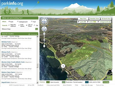
ParkInfo.org Full Parks Info in 3D
View Data from 3d ParkInfo.org combines the cartographic and the terrain to produce highly effective visualisations of the campgrounds and park boundary information.

The non-profit www.greeninfo.org Network has just put up a new version of its ParkInfo web site, offering up some great web map cartography that shows every public parks and protected open space in California, along with nifty integration of Google Maps API and Open Street Map data, Google Earth overlays, multiple search tools and more.
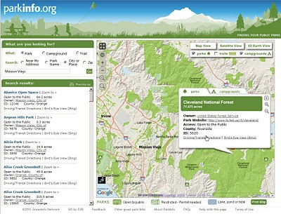
ParkInfo.org Map Parks
Full information on Parks, Campground at a click of a button.

ParkInfo uses the California Protected Areas Database (CPAD), a comprehensive and highly accurate GIS data set of everything from neighborhood tot lots to vast federal wilderness areas, almost all mapped to official property ownership boundaries. GreenInfo Network, which works for public interest groups on a wide range of GIS and information technology projects, maintains the 49 million acre, 15,000 unit CPAD database. CPAD is available for non-commercial use at www.calands.org , and has been developed with ESRI ArcGIS software.

The web site features the CPAD lands that are open to public use (some require a permit). The site lets users search near an address, by park or city name, or in a zip code. Search results show as lists and on the map and all parks on the map are clickable with more information - including a direct web link, driving/transit directions (via Google Maps Directions) and a link to Bing's Birdseye view of the site. The web map can also be enlarged to full screen to take advantage of the great cartography.

GreenInfo shifted from using Google's Streets view to its own custom MapView, which features 10 meter DEM data in an attractive hillshade and well-styled Open Street Map streets. When fully zoomed in, users also see contour lines. In addition to Satellite view, users can also easily browse all the ParkInfo data using the Google Earth plugin. ParkInfo also has all public campgrounds in the state and a selection of Open Street Map trails.
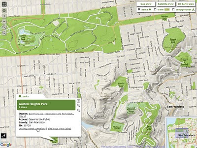
ParkInfo.org TopOSM Map
TopOSM terrain tiles have been used to show relief in 2D view for ParksInfo.org

Map tiles were created using the TopOSM scripts and rendering process created by Lars Ahlzen see http://toposm.com/usw/ for example. Areas, streets and labels are rendered using Mapnik. PostgreSQL with the PostGIS extension provides the spatial query capabilities for ParkInfo while a MapServer Web Map Service (WMS) GetFeatureInfo request returns park details when a user clicks on a park.

View the Map in 2D and 3D - http://www.parkinfo.org/

ParkInfo can be adapted into other organizations and agencies' web sites, allowing them to offer full search of public recreational opportunities. The State of California Department of Parks and Recreation has already done so at http://Findrecreation.parks.ca.gov

Composed by Larry Orman from http://www.greeninfo.org/ with thanks from Mapperz
GreenInfo is exploring an API as well as expanding ParkInfo to other U.S. states. Contact them at: parkinfo@greeninfo.org

Labels: , , , , , ,

21 May 2010

Google Maps API Styled Map Wizard

Google Maps API Styled Map Wizard
*change Google Maps to suit your website colours and style.

Google Maps are instantly familiar by users interface the familiar look and feel of Google maps on any web site. All that can now change thanks to the Google Maps API v3 Style Wizard.

Google Maps API Styled Map Wizard bad carto
Make really bad colours if you want


Google Maps API Styled Map Wizard better carto
or something slightly more cartographically acceptable.

Use this http://gmaps-samples-v3.googlecode.com/svn/trunk/styledmaps/wizard/index.html
If you want your map to stand out from the crowd, your options are limited to customizing the markers and controls, and if your brand has a particular colour scheme that is reflected on your site, Google Maps may not sit well with it.

"You are now free to unleash your creativity on the base Google map itself, as we are delighted to launch Styled Maps in the Google Maps API v3."

Styled Maps offers you control over both the types of features shown on your maps, and the colour scheme used to represent them. The possibilities are endless....

See more Examples here:
http://maps-api-tt.appspot.com/apilite/styled/styled.html

Source:
http://googlemapsmania.blogspot.com/2010/05/add-style-to-your-google-maps.html
Official Post:
http://googlegeodevelopers.blogspot.com/2010/05/add-touch-of-style-to-your-maps.html

Labels: , , , ,

19 May 2010

Bye Bye Google Maps API v2 - V3 Graduates

Bye Bye Google Maps API v2 - V3 Graduates

was coming sooner or later...

As part of the Google Maps API v3 graduation to the principal maps API Street View has been added to the Maps API v3.

Street View in v3 is entirely implemented in HTML in order to accommodate all of the mobile devices on which v3 is supported. In v2 of the Google Maps API Street View relied on Flash.


Streetview now available in V3 of the Google Maps API (drag pegman to active the HTML version of Streetview)

In order to ensure that existing Maps API v2 applications can be migrated to Maps API v3, we have also been striving to add all of the most popular v2 features to v3. As part of that effort we are also happy to announce that Street View is now available in the Maps API v3.

When you use Street View in v3 you will notice a number of differences with v2. The most significant change is that Street View is entirely implemented in HTML in order to accommodate all of the mobile devices on which v3 is supported. We have also added Pegman support to the map, and a number of new features, including markers, infowindows, and custom imagery.

In conjunction with the graduation of the Maps API v3, we are also announcing the deprecation of the Maps API v2 and Mapplets (which is based on v2). These deprecation announcements confirm that no further feature development is planned for these two APIs. However, we will continue to maintain and support applications using these APIs for at least three years consistent with the deprecation policy detailed in the Maps API Terms of Service.


Sources:
http://googlemapsmania.blogspot.com/2010/05/google-maps-api-v3.html

Links:
http://googlegeodevelopers.blogspot.com/2010/05/they-grow-up-so-fast.html

Labels: , , , , ,

12 May 2010

Google Maps API v3 New Features

Google Maps API v3 New Features

3 New Features have arrived at the V3 Google Maps API


  1. KML Overlays
  2. Biking Directions (selected USA Cities currently)
  3. Traffic Layer
KML Overlay Google Maps API v3
Google Maps API v3 now supports overlaying of KML files.

Bike Routes Google Maps API v3
Bike Routes are now enable for overlay for Googel Maps API v3 in selected cities across the United States.

Traffic overlay Google Maps API v3
Also Traffic Overlay is now available for use on v3 of Googel Maps API

You maybe interested in 'Boxer Router'
http://googlegeodevelopers.blogspot.com/2010/05/search-along-route-made-easy-with.html
credit to

and
Marker Manager 1.0 for v3
http://googlegeodevelopers.blogspot.com/2010/04/markermanager-10-manage-your-markers-in.html
credit to )

source with documentation
http://googlegeodevelopers.blogspot.com/2010/05/kml-traffic-and-bicycling-layers-come.html

Labels: , , , , , ,

08 December 2009

Birds Eye View - Google Maps API - New

Birds Eye View - Google Maps API- Aerial Imagery
*limited coverage currently
**currently only available via the Google Maps API V2)

Users of Bing Maps (Virtual Earth/Live Maps fame) will recognised this maptype.

Birds Eye View Google Maps - New Map Mode
New Map Mode - Tilted Aerial Imagery comes to the Google Maps API.
(techies call it oblique aerial and its taken from aircraft from the side or front)
getmapping has a good set of examples
http://www2.getmapping.com/Services/Obliques


"Starting today [8th December 2009], developers will have access through the Google Maps API to high-resolution overhead imagery that is presented in a new aerial perspective. This is currently available in 2 spots in California: San Jose and San Diego. This new perspective gives users the ability to tilt their view of the world. In addition to seeing hotel rooftops like in our current "satellite" view, users can now see both the rooftop and sides of the hotel at an angle. In fact, users can rotate around all the sides of a hotel to get 4 different views from back to front"

2 Official Blog Posts
http://googlegeodevelopers.blogspot.com/2009/12/getting-better-view-with-maps-api-v2.html

http://google-latlong.blogspot.com/2009/12/changing-your-perspective.html

"What's great about this new imagery is that all of your existing data and Google Maps services like driving directions can be displayed on your map with no extra work. This is a result of a lot of code and computing power that reprojects the imagery to make it easy to overlay data on the map given lat/lon locations like in any other Google Map type. The result is a great user experience together with easy display of data on the map"

Documentation
http://code.google.com/apis/maps/documentation/introduction.html#AerialMapTypes

Examples:

Simple
http://code.google.com/apis/maps/documentation/examples/aerial-simple.html
Now with Auto-rotate
http://code.google.com/apis/maps/documentation/examples/aerial-rotation.html

@mapperz uber widescreen version (1200x800)
http://mapperz.googlepages.com/Aerial_RotateGoogle_Maps.html

Labels: , , , , ,

21 May 2009

Google Maps API Adsense (Revamp) - May 2009

Google Maps API Adsense (Revamp) - May 2009

"a new feature that will enable geo developers to generate advertising revenue from their Google Maps API mashups"

Note: Google AdSense for Content account required to obtain a publisher ID

Mapperz Testing Adsense Google Maps API May 2009 Revamp
Live Example (few tweaks required)
http://mapperz.googlepages.com/Mapperz_Testing_Adsense_May2009.html

Sources: (and helped solved the issues)
http://groups.google.com/group/Google-Maps-API/browse_thread/thread/79da87885e4b879d#

Official Blog Post:
http://googlegeodevelopers.blogspot.com/2009/05/earn-revenue-from-your-mashup-with-maps_20.html


Labels: , , , ,

23 January 2009

Interactive Google Maps API - Playground - New!

Interactive Google Maps API - Playground - New!

Confused by code? Want to see how the pieces of code fit together to create Google Maps API mashups? Interactive fully editable code and then click Run to see the result.

Interactive Google Maps API Playground

Code Menu button allows the user to save the source
Export creates an id and uses the 'http://savedbythegoog.appspot.com' (Google App Engine) to make a page live, login and and this is saved in a 'Saved Code' Menu

Custom Saved AJAX Playground
Saved Code [requires login]

Here is an excellent new section to the Google Maps API Documentation http://code.google.com/apis/maps/documentation/reference.html Code Samples > Code Playground - New!

Hopefully this inspires more developers and people interested in creating their own maps based on Google Maps. This new interactive page gives users a jump start in the right direction.


Virtual Earth has had an Interactive SDK page for quite a while now available at:
http://dev.live.com/Virtualearth/sdk/

(not editable code unless copy and paste into an editor (notepad or dreamweaver etc))

The Google Interactive Playground is now also available for:

Visualization API (includes Chart API)
Search API
Language API (Translate)
Blogger Data API
Libraries API
Earth API
Feeds API
Calendar Data API


Source:
http://google-code-updates.blogspot.com/2009/01/playing-around-with-googles-ajax-apis.html

Labels: , , , ,

08 January 2009

Google API Geocoder Updates [ExtendedData]

Google API Geocoder Updates [ExtendedData]

Update 13/01/2009

Google chrome users will be happy to know if you update to version (2.0.156.1)
your get the bounding box response from the Google Geocoder.


How to get Google Chrome 2 (Beta)?
http://dev.chromium.org/getting-involved/dev-channel

---------------------------------------------------------

Google Developers have been promising this for a few months now but finally it has made it to the real world. The Bounding Box has made it to the geocoder.

What is new?
Google Maps API Group has a suggestion/requests/issue tracker and one was for the bounding box (SW Corner and NE Corner) to be return when a geocode is sent to the google geocoding servers

Now you get the bounding box not just the centre coordinates

http://maps.google.com/maps/geo?output=jsonl&oe=utf-8&q=10%20Downing%20Street,%20Westminster,%20London&gl=uk&key=ABQIAAAA5heAddVpewIi0Vy-FvLfBBQ6SKP0Jc9Qt0dvx

now returns:
{
"name": "10 Downing Street, Westminster, London",
"Status": {
"code": 200,
"request": "geocode"
},
"Placemark": [ {
"id": "p1",
"address": "10 Downing Street, Westminster, London, UK",
"AddressDetails": {"Country": {"CountryNameCode": "GB","CountryName":
"United Kingdom","AdministrativeArea": {"AdministrativeAreaName":
"Greater London","Locality": {"LocalityName": "London","PostalCode":
{"PostalCodeNumber": "SW1A 2","AddressLine":["10 Downing Street"]}}}}
,"Accuracy": 9},

"ExtendedData": {
"LatLonBox": {
"north": 51.5063886,
"south": 51.5000934,
"east": -0.1238814,
"west": -0.1301766
}
},
"Point": {
"coordinates": [ -0.1270290, 51.5032410, 0 ]
}
} ]
}

Why the fuss?
Well now this extra [Extended information] can be used to set zoom levels for your map.

"Now, in the KML/JSON outputs, you'll also get information about the
recommended bounding box associated with a geocode. You can then use
that along with map.getBoundsZoomLevel(GLatLngBounds) to set an
appropriate center and zoom after a geocode. "

Available
"in the HTTP Geocoder output and JS/Flash Geocoder functions."
Not Available currently in the static api.

Source:
http://groups.google.com/group/Google-Maps-API/browse_thread/thread/b95422a18f8701ed?hl=en#

Well Done Google Map API Team


Potential Future Requests
Altitude (feet or metres)
Time Zone (+1GMT -7 GMT etc)
Standardize the output between formats
Translate place names (Local >English or English to Local)
Accuracy of Rooftop geocoding response
Sea/Ocean Geocoder (Atlantic, Black Sea etc)


Labels: , , , ,

13 August 2008

Google Maps API - Walking Directions

update - from The Google Maps API Team

"This is the testing version of the Maps API JS, is not meant for production, and is liable to change at any time. Only use it for your personal experiments, and don't be surprised if it breaks later."


Google Maps API - Walking Directions
New!
Google Maps API Walking Directions New
Previously only 'Walking Directions' was available in Google Maps - Now available to be customised in the Google Maps API.

Try Mapperz version
http://mapperz.googlepages.com/Google_Maps_API_Walking_Directions.html


Thanks to Mike Williams with his useful and informative posts (usually with an example or two) on the Google Maps API Group with Version changes to the API. Walking Directions is made available in version *v2.124.


*Warning v2.124 is still subject to change.

source:
http://groups.google.com/group/Google-Maps-API/browse_thread/thread/0a12fef4439790cf#

v2.124 adds walking and avoid highways routing to the API.

The new GDirectionsOptions are:
{travelMode:G_TRAVEL_MODE_WALKING}
{avoidHighways:true}

The defaults are
{travelMode:G_TRAVEL_MODE_DRIVING}
{avoidHighways:false}

Example: http://econym2.googlepages.com/temp_walk.htm

Note: API v2.124 is not yet live. It's possible that the code may be
changed before it goes live.

Labels: , , , ,

10 July 2008

ArcGIS JavaScript Extension for the Google Maps API

Updated see red and blue below

ArcGIS JavaScript Extension for the Google Maps API
"The ArcGIS JavaScript Extension for the Google Maps API allows you to use your ArcGIS maps and tasks in the framework of Google Maps. There are many reasons to use this extension to expose your GIS data. Perhaps your audience already knows how to use Google Maps. Perhaps you're already familiar with the Google Maps API. Or maybe you just like the look and feel of the Google base maps."

Google Maps + Powerful GIS Analysis
ESRI GMAP API Directions with profile UK
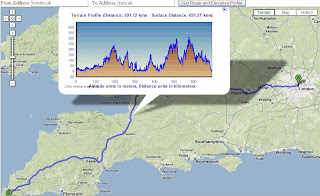
Here is a Google Maps Direction Route - with the added profile of the route generated by ArcServer. (click image to see live example)

Here is another example of adding GIS capabilities to Google Maps.

ESRI Google Maps API DriveTime
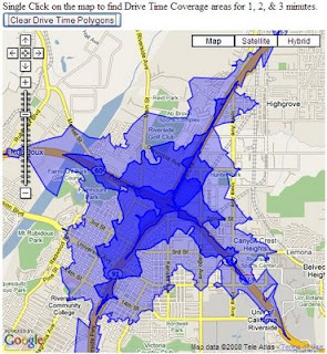
Drive Time Polygons (1,2 & 3 minute driving time polygons) on the fly - overlaid on Google Maps. (click image to see live example)
Custom version http://mapperz.googlepages.com/DriveTime_ESRI_GMAP.html
(Drive Time only works in the US and Canada)

How is this geo-processing action created?

Create Drive Time Polygons - ArcGIS Model
Image source: http://globe5.arcwebservices.com/arcgisoutput/Network_ESRI_DriveTime_US/CreateDriveTimePolygonsDisks.htm

ArcGIS comes with Model Builder here geoprocessing functions Make Service Area Layer, Add Locations are just some of the core processing elements to create Drive Time Polygons.

This is the start of some serious and powerful tools that will and can be built on to 'enrich' the map user.
This provides them with detailed information that can be manipulated and customized to the users specifications on the fly.

Other possibilities at the Geo-Processing Service examples here
  • Display your own maps on top of a Google Maps base map.
  • Execute a sequence of GIS models and display the results in Google Maps.
  • Search for features in your GIS data and display the results on Google Maps.
  • Find addresses using your own address locator and display the result on Google Maps.
  • Display attributes from your GIS data on the map using the Google Chart API.
  • Allows others to add GIS functionality from your server as a Google Mapplet.
The future looks bright with GIS software companies taking on popular mapping API's

Please note there is an ArcGIS JavaScript™ Extension for Microsoft Virtual Earth™ version as well.

Reported by Google Map Mania from this Blog


Labels: , , , , ,

03 April 2008

Google Maps Annotation (Label) Generator

Google Maps Annotation (Label) Generator

Google Maps Labels Annotation Generator


Easy to Create and Change - Limited Fonts


Can output in 3 formats
KML
Javascript (for Google Maps API)
Images

Try your own Label Generation here
http://ec.geoblogspot.com/GELab/ecLabel.htm

Credit to Valery Hronusov

Source:
http://googlemapsapi.blogspot.com/2008/04/text-images-without-much-coding.html

Labels: , , , , , ,

28 March 2008

Google Maps API adds StreetView Officially

update:28/03/2008

and there is the impressive Dual Maps - Virtual Earth and Google Map with StreetView side-by-side.


When you move the Maps/Streetview updates, when you turn the birdseye/streetview turns
Dual Maps by the Beach
Google Maps with StreetView and Virtual Earth with Birdseye View side by side at the beach.

Google Maps API adds StreetView Officially

New cities or StreetView coverage expanded
Albuquerque, NM
Anchorage, AK
Austin, TX
Cleveland, OH
Fairbanks, AK
Little Rock, AR
Madison, WI
Nashville, TN
Rockford, IL
Richmond, VA
Spokane, WA
St. Petersburg, FL
Tampa, FL
Yosemite National Park, CA
(thanks GoogleMapsMania saved Mapperz a job)


Google Maps API StreetView Drive
Why not 'visualize' the drive before you go?

Now you can custom build your own Streetview maps (subject to coverage).

Several good examples are available view:

Clickable StreetView Layer

Query StreetView Tiles/Structure


StreetView Layer and Draggable Human Icon

StreetView Panorama with POV (Point of View)


http://code.google.com/apis/maps/documentation/demogallery.html?searchquery=street


Source:
http://groups.google.com/group/Google-Maps-API/browse_thread/thread/6e025c86acfc1002/bf0174dced87cc9e#bf0174dced87cc9e

Official Blog Post
http://googlemapsapi.blogspot.com/2008/03/street-view-in-api-or-how-i-spent-my.html

Documentation (uses v2.104)
http://code.google.com/apis/maps/documentation/reference.html#GStreetviewPanorama

Labels: , , , ,

08 February 2008

Popular Baby Names World Map (Beta)

Popular Baby Names World Map (Beta)

Popular Names World Map

http://www.babynamemap.com/

Guy Davis has updated a very clear and fast map of popular names around the world.

"I wanted to send out a big Thank You to the Google Maps developers for creating a great tool and making it easy to build applications upon. Ever since the API was announced I've been looking for an opportunity to build something useful with Google Maps. When I found out that my wife and I were expecting our first child, my searches for popular baby names yielded a bunch of sites with boring old static HTML tables of data.
So instead, I've aggregated popular baby name statistics and show them on a Google Map which makes exploring this dataset a lot more interesting. If you're interested, check out the Baby Name Map at:
http://www.babynamemap.com

Hopefully others will find the map useful as well. Keep up the great work on the API. I look forward to incorporating more new features into the map. "
From the Google Maps API forum and receiving lots of positive responses


New features are:
Floating windows
  • Tab panes
  • Dynamic trees
  • Interactive data tables
  • Flags of the world (tree directory)

"The new tree of countries makes it easy to navigate around the map and let me make use of some more interesting features of Google Maps. Now I need to update the map with some of the recent 2007 statistics."

Mapperz suggestion - Google Maps API with Google Chart API might work very well with this type of information, comparing names and statistics with location.

Labels: , , , , ,

24 September 2007

Route Scanner - Incidents and Delay Map

Route Scanner - Incidents and Delay Map

This is a fantastic UK Route Planner that works out delays, incidents and tells you the speed/traffic light camera locations along your own route.

Route Scanner created Paul Clark
Paul Clark has developed a clean and informative results page - Colour coded to severity (shades of red).
Uses the Google Maps API Driving Directions and Live Feeds from BBC Travel and the Highways Agency

Quick Guide
  1. Enter your start and destination.
  2. Choose a Buffer distance (1,2 and 5 miles)
  3. Choose Speed Cameras (Don't Show,Show Speed Cameras, Show All)
  4. Press 'Serach'

"Route Scanner uses live traffic information (e.g. accidents, roadworks and delays) combined with a route planner to calculate which incidents could affect that particular journey. It combines the power of Google Maps with the real-time information provided by BBC Travel and the Highways Agency. Route Scanner doesn't just look for traffic and travel updates on motorways and other major roads but through the road network."

Paul Clark also has developed other websites...
Well Done for creating an Excellent UK Mashup
Mapperz

Labels: , , , , , , ,

13 September 2007

MapNik - OpenStreetMap - Google Maps API (Custom Tile)

MapNik - using OpenStreetMap in Google Maps API (as a Custom Tile)

Mapnik Map Transition with Google Maps
MapNik with OpenStreetMap (Oxford,UK) using Google Map API (Custom Tile) works really well. (gif transition created by Mapperz)

"Mapnik is a Free Toolkit for developing mapping applications. Above all Mapnik is about making beautiful maps. It is easily extensible and suitable for both desktop and web development."


UPDATE Starting from 0.4 Mapnik runs on Linux, Mac OS X (10.4.9), Win32 and FreeBSD


Mapnik can read ESRI shapes, PostGIS databases and TIFF rasters
more?
"As always, there are lots of things in the pipeline"

Features

  • Projection transformations
  • Multiple named styles in WMS

  • Line following' text labels
  • 'Shield' symbolizer
  • Feature querying
  • Character encodings support
  • GetFeatureInfo with text/plain and text/xml output
  • Support for right to left languages
If you want to see the functionality of Google Maps and the more detailed (less in some respects)
go to the Demo Area of MapNik website for more examples.

There are other Maps available (a good working one it Victoria, British Columbia)
http://mapnik.org/maps/


*Mapperz used Adobe Image Ready to visualize the cartographic differences between MapNik and the Normal tiles available in Google Maps API

Labels: , , , , ,

08 September 2007

Google Maps API Clickable Lines & Polygons

modified by Mapperz)

In the latest release (v2.88) of the Google Maps API, Lines (Polylines) and Polygons are now clickable events to GPolyline and GPolygon, much to the enthusiasm of developers in the Google Maps API Group Forum. Since a few developers started speculating on how this is being implemented in the API, all the juicy details right here. Warning: Algorithms ahead!

Polyline Hit Detection

As polylines have no intrinsic width, detecting clicks on polylines is something of a judgement call. To detect polyline clicks, this method needs to determine two things

  • Whether clicks are close enough to a polyline to count as a click
  • Which segment of the polyline is the closest to the click.

Overview of the Algorithm

Click detection begins by measuring the distance (in pixels) between the clicked point and the polyline. For each segment of the polyline, the computed distance between the clicked point and the nearest point along that segment. Then take the minimum of these distances as the closest segment; if the distance is then small enough, it is declared as click on the polyline.

Reducing the Sample Set

Note that the simple algorithm has to look at every segment of the polyline. It can be quite slow for big polylines i.e. driving directions). There are a few heuristics which drastically improve the simple algorithm:

  • Given the bounds of the currently visible map viewport, discarded points which are off screen. This can drastically reduce the number of points to consider.
  • Zooming out from a detailed polyline, generalising the segments of the polyline into a simpler group of segments without noticeably changing its shape. In the example below, a simplify a polyline from 9 points at the highest zoom level to 4 points at a more zoomed-out level.

Using Bounds Trees

If a clicked point is far away from a segment, it is discarded from consideration. Taking advantage of this fact by pre-computing the bounds of groups of segments; if a clicked point is far from these bounds, it skips distances for all of the enclosed polylines. By recursively combining these bounds for larger and larger groups of segments, "bounds tree" that allows to skip most of the segments when performing hit detection.

This dramatically speeds up polyline hit detection. For example, detecting clicks for complicated polylines like the Camden Cycling Map.

Camden Cycle_Map - Clickable Lines

Polygon Hit Detection

Detecting whether a clicked point is within a polygon is more straightforward, and less open to interpretation. We first draw a straight line from the clicked point to the right of the screen. Each time this test line crosses a segment of the polygon, it changes state from being inside to outside or vice-versa. If the test line crosses an odd number of segments then the point is determined to be inside the polygon, whereas if the test line crosses an even number of segments then the point must be outside.

Many of the same improvements for polylines in polygon detection, using the map viewport and zoom level to drastically reduce the number of segments to consider, and using a bounds tree to avoid performing unnecessary intersection tests.


Original Post modified here by Mapperz

Camden Cycle Campaign is one of the very first to use this functionality in full effect. Well done.

"Our primary aim is to get more people to cycle and to improve things for those who already do so."

Labels: , , , , ,

17 August 2007

Exclusive - Reverse Geocoding using Google Maps API only!

Exclusive - ALL New! Reverse Geocoding using Google Maps API only!

Google Maps is great! and the programmers that take the API and do find and create useful applications. Like this Reverse Geocoding

What is reverse geocoding?
"The conversion of latitude and longitude coordinate data of locations into descriptive addresses"

Reverse Geocoding UK Addresses

Try it out here
http://nicogoeminne.googlepages.com/reversegeocode.html

Thanks to Nico Goeminne for finding this algorithm and giving Mapperz the chance to suggest and give exclusive feedback on this incredible function.

Is this legal? - Yes, We have had this confirmed by Pamela Fox (Google Maps API Team) that this is not breaking the Terms of Use - which is great news.

"I checked with a product manager and he looked through our licensing
agreements. The conclusion is that as long as you're not using the
reverse geocoder for real-time tracking of any kind, then you're okay
to use it."

Please use it - suggest comments, feedback always welcome.

Nico's idea came from this
"Google Maps is great! One day I was working on a treasure hunting game, it combined both real world as virtual items placed in and around the very nice city of Ghent (Belgium). At regular times I told them the location (GPS) of an item, so they could go out hunt. Some of them complained because they didn't have a GPS and couldn't find an online tool to convert the GPS coordinates to an address. "No problem I said, I'll fix one up", at that time I did not cross my mind that GM couldn't reverse geocode since before all things I ever needed were just there in that great API. So I was kinda disappointed when I read trough the documentation and even more when I searched the net on the subject. So in the end, I decided to give a try myself and see if I could figure out something and then I stroke me : The GM API has reverse geocoding capabilities. They just call it Driving Directions! Google Maps is great! "

Thanks and all credit to Nico - Excellent Job!

Mapperz Tests a UK version of this method (demo)

Labels: , , , , , , , ,