->

24 February 2011

Embed ArcGIS Online Maps for Free

Embed ArcGIS Online Maps for Free


View Larger Map

required > OpenStreetMap and the license (CC-by-SA). < http://wiki.openstreetmap.org/wiki/OpenStreetMap_License#Attribution">OSM attribution).

A fix is required on the ESRI side [code]

Thanks to David highlighting the issue.
http://lists.openstreetmap.org/pipermail/talk/2011-February/056894.html

Full Screen Map
http://www.arcgis.com/home/webmap/embedViewer.html?webmap=1907d8d1c2954484b4b6569b5d8de305&zoom=true&scale=true


ArcGIS Online Example & Make your Own Map(s)
http://www.arcgis.com/home/
source:
http://nygeog.blogspot.com/2011/02/embedding-arcgis-online-maps-open.html
deleted by poster.

Labels: , , , ,

21 February 2011

Rain Alarm Map

Rain Alarm Map

Rain Alarm Map


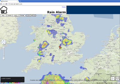
Get live alerts for incoming rain or snow.

The simple idea of this web map and app is to warn you against approaching precipitation like rain or snow. Therefore the app checks in a perimeter of 75 km / 47 miles every 30 minutes, if there is something approaching. Simply leave the page open in the background and you'll get notified.

Note that the map is refreshed automatically so you do not have to reload the page. The buttons on the bottom right en- or disable the animation and the alarm functionality.

The data used originates from governmental weather services and is available for the USA, Canada, Australia, the UK, Ireland, Norway, Germany, the Netherlands, Spain including the Balearic and the Canary Islands.

Browsers:
The alarm notifications work best with Google Chrome. For Mozilla Firefox and Microsoft Internet Explorer the alarms work as well, though they are not as pretty and intuitive.

With some browsers your location can be determined automatically or otherwise a rough estimate is used. To correct your location, simply drag the marker to be able to receive correct alarms.

Internet Explorer
You need to keep Rain Alarm as the active tab to be able to receive alarm notifications even when the Internet Explorer is minimized.

Mobile

The app is also available for Android as well as iOS.

Map:
http://www.rain-alarm.com/

Source:
http://googlemapsmania.blogspot.com/2011/02/google-map-warning-of-rain.html

Labels: , , ,

15 February 2011

National Address Gazetteer (GeoPlace)

National Address Gazetteer (GeoPlace)

Press Release from the Office of Fair Trading (OFT)

The proposed joint venture combines the spatial address databases of Ordnance Survey and the Local Government Improvement and Development Agency (LGID), to create the National Address Gazetteer, a database of accurate geo-referenced addresses in England and Wales. This data is relied upon by the public and private sector to accurately locate addresses when delivering services such as public transport, road maintenance, utility management and emergency call-outs.

The OFT found that the parties provide the only two accurate geo-referenced addressing databases, and do not face competition from less frequently updated and geographically accurate databases, such as those used by satnavs. Consequently it found that the joint venture would create a monopoly in this market.

However, the OFT concluded that it was not proportionate to refer the market to the Competition Commission because:

  • the Government is the parties' largest customer and will continue to enjoy substantial buyer power and influence over the joint venture
  • in practice there has been limited opportunity for the private sector customers of the two parties to trade one off against the other, and in any case the size of the affected private sector market is relatively small and
  • virtually all customers, both public- and private-sector, strongly supported the creation of the new database.
The plan is to be fully operational by April 2011, with the first data made available in summer or early autumn of 2011
Vector1Media

Full Press Release
http://www.oft.gov.uk/news-and-updates/press/2011/18-11

Ordnance Survey
http://www.ordnancesurvey.co.uk/oswebsite/media/news/2011/feb/geoplaceapproval.html

GeoPlace™ Q&As
http://www.lga.gov.uk/lga/core/page.do?pageId=15377046

Labels: , , , , ,

09 February 2011

Natural Earth Free Map - Updated Data

Natural Earth is a free, public domain map dataset available at 1:10, 1:50, and 1:110- million scales and includes new vector and updated raster themes. The goal is to give cartographers and GIS users an off-the-shelf solution for creating small scale world, regional, and country maps.

To celebrate the 1 year-anniversary of the Natural Earth project by introducing a new "quick start kit" (150 mb ZIP) that includes a sampling of Natural Earth vector and raster data and an ArcMap document that compiles the themes into an easy to browse, styled map. The map comes in two flavors and scales: the world (zoom to all) and at a regional scale (zoom in to U.S. states and countries world wide) with cultural and physical data frames to switch between.

You can download individual themes (or the whole set) from naturalearthdata.com, where you'll find raster imagery of Natural Earth I and II in perfect registration with the vector linework. Both political and physical features are included in Natural Earth data.

Natural Earth solves a problem that many map makers face: finding vector data to make publication-quality small scale maps. At a time when the web is awash in interactive maps and free, downloadable vector data, such as the Digital Chart of the World and VMAP, map makers are forced to spend time sifting through a confusing tangle of poorly attributed data. Many map makers working under tight project deadlines must use manually digitalized bases instead.

natural earth screenshot

Small scale map datasets of the world do exist, but they have their problems. For example, most are crudely generalized—Chile's fjords are a noisy mess, the Svalbard archipelago is a coalesced blob, and Hawaii has disappeared into the Pacific two million years ahead of schedule. They contain few data layers, usually only a coast and country polygons, which may not be in register.

The lack of good small scale map data is not surprising. Large mapping organizations that release public domain data, such as the U.S. Geological Survey, are not mandated to create small scale map data for a smaller user community that includes map making shops, publishers, Web mappers, academics, and students—in other words, typical cartographers.

Nathaniel Vaughn Kelso, The Washington Post

Tom Patterson, U.S. National Park Service

Originally Posted by ESRI Mapping Center http://blogs.esri.com/Support/blogs/mappingcenter/archive/2011/02/08/natural-earth-the-free-world-base-map.aspx

Labels: , , ,

02 February 2011

Crime Maps England & Wales

Crime Maps England & Wales

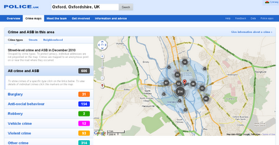
Recorded crime in England and Wales on Google Maps - find what crimes have been committed in their neighbourhoods.

The map shows crime mapped to "an anonymous point on or near the road where they occurred." NOTE: Individual addresses are not pinpointed on the map.

To search for crime in an area users can enter a postcode or an address. The map will then display the crimes committed in a radius of the submitted location. The maps include a pretty neat marker clustering system and the number of crimes are also broken down by category.
Crime Maps  England & Wales
Crime Maps for England and Wales - to Street Level - Search by postcode, town name or street.

Example:
http://www.police.uk/crime/?q=Oxford,%20Oxfordshire,%20UK#streets

Built on the API - http://www.police.uk/api/docs/

Source:
Google Maps Mania
http://googlemapsmania.blogspot.com/2011/01/uk-launches-national-crime-map.html

Interesting related post on the Guardian
http://www.guardian.co.uk/technology/2011/feb/02/uk-crime-maps-developers-unhappy

Labels: , , , ,