->

31 July 2006

Yahoo Maps with GPS Routes with Elevation

Yahoo Maps with GPS Routes with Elevation
Yahoo Maps with GPS Routes with Elevation where you can add your own routes and view elevation before you set off.

Flock to Google Maps

Flock_Google Map Extension
A new extension that makes it easy to Drag n drop addresses on webpages which shows location in a google map.


A video(soon to be on google video) shows how it works - the suggestion that a low res version for less bandwidth users would be useful has been done.
link for video coming when google have verified it.

30 July 2006

ArcGIS on Mac OS X with Intel Chip

ArcGIS on a Mac
ESRI do not support this but it is possible to run ArcGIS on an Apple Mac with an Intel Chip Inside (annoying intel tv ad removed here). Seems that if there is a will there is a way...

Well done and credit to Christian Spanring
Ingredients needed
One New Intel Apple Mac
Boot Camp (Windows XP emulator for Mac OS X)
Parallels Desktop for Mac

Airport Finder with Map

This search finds your nearest airport and shows you a map of the nearest available ones. Clean search and gives good results

Airport Finder with Map
"Scheduled airlines use fewer than 10% of the world's available airports. Chartering an aircraft gives you access to all airports, including regional, local and private airfields."

29 July 2006

Happy Map

Based on studies conducted over a 3 year period the world has been mapped by happiness
World Happy Map

"The Happy Planet Index (HPI) is an innovative new measure that shows the ecological efficiency with which human well-being is delivered." nef

credit to CCA Blog a very useful map finding blog.

28 July 2006

Ordnance Survey Maps in Google Maps

Ordnance Survey Maps in Google Maps


Use the slider at the bottom to adjust transparency between OS maps and Google maps

This site shows several out of copyright Ordnance Survey maps, the maps range in date from around 1925 to 1945. Copyright is released after 50 years.

It would be possible to have a seamless 1:10,000, 1:25,000 and 1:50,000 scale mode with up-to-date maps but you would be breaking Crown Copyright

27 July 2006

Google Maps Database Chunker

Google Maps Database Chunker is a very hand tool for controlling the amount of data you display spatially on a google map. Lots going on in the background (hidden to the user) but you get faster display of third party data on your google map.

Google Maps Database Chunker

In a few tweaks time, will be a very hand tool (if not already).

See the sample here

Credit to 'darkhelmet'

Upside Down World Maps

The World of maps upside down.
Upside Down World Map
UK Still in the Middle - Projection Van Der Grinten

Antipocentric Upsidedown Map
Antipocentric (UK not in the Middle Map) in the Underground Design and Specification.

source:Flourish

26 July 2006

Exclusive New Continental Wall Maps Preview

New updated Wall Maps from Maps International

Australasia Political Wall Map

More detailed than before.

Asia Political Wall Map
Professional handmade hillshading.
Extra bathymetry
On North America, States are added and Canada Territories
Major national parks and preserves added.

To pre-order these maps contact Maps International

Live Traffic Data On Your Phone

Google now provide Live Traffic Data on your mobile/cell phone.
Unfortunatley only for the USA.
"See where the congestion is, and estimate delays in over 30 major US metropolitan areas."
Unlikely for the UK or Europe to have it in the future.

Google Maps Mobile Live Traffic
Uses a Java Applet (.jar) which is available to download from GMM. Support devices are here.

uDig GIS - A Friendly Free GIS

uDig Free GIS
A Friendly Free GIS

"uDig 1.1-RC2 has now been released. This release features bug fixes to improve Postgis and WFS editing as well as a focus on improving user feedback when importing data"

Works on Windows,Apple Mac OSX and Linux see Downloads

25 July 2006

World Wind Finder Map

Find current wind conditions across the world. Clickable raster maps.

Wind Finder Map

Wave/Swell
map also available

Retro GIS ESRI ArcVoyager

James Fee, still waits (as we all do) for ArcGIS Explorer to be released (even in beta status) and has been having a retrospective view of past GIS applications.
This caught mapperz eye.

ArcVoyager Lighweight GIS

One such program was ESRI's ArcVoyager
Sounds more like space exploration than a lightweight desktop GIS.
It is still available to download.

Oh how we have moved on... thankfully.

"ArcGIS Explorer will be available with the release of ArcGIS 9.2." (this line has been subject to change from the ESRI Website since April 2006.)
So now due October 2006 for the USA and due to shipping 6-8 weeks later for UK users.

24 July 2006

Cartogram Maps of the World

Energy Consumption Map
Showing distorted maps that visualise engery consumption, population, child mortality, greenhouse gas emissions etc by country.

More available at WorldMapper

A very good comparison is the UK Population against Canada.

23 July 2006

Cyber Nations

Sample Cyber Nation map
Always wanted to be master of your own kingdom?

Rule a country with the government of your own choice?

Determine your own tax rate and currency?

Now you can!

Cyber Nations is a nation simulation game built around Google Maps.
Create a nation using a real-world map and decide how you are going to run that nation.

22 July 2006

Crisis in the Middle East: Mapping the Conflict

Map of Israeli - Hezbollah conflict area
The Middle East conflict from the bloggers point of view.

An interactive map providing links to bloggers covering the Israeli-Hezbollah conflict as well as news feeds with maps showing the region the information is for.

21 July 2006

Google Maps Speed Boost

Again the Google Maps team listen to thier users and developers...

Google Maps Boost Speed
They have vastly improved the performance of removing the markers (or icons) on the google maps. Soon a boost for the Overlaying of third party data.


"Significant speed improvements in removeOverlay() and clearOverlays(). As promised, we've made removing overlays much faster. According to our tests, removing 100 markers now takes 1.5 seconds instead of 18 seconds in Internet Explorer, and 0.5 seconds instead of 8 seconds in Firefox. See for yourself. Next up, we're working on making addOverlay() faster."

Good work Google.

20 July 2006

Map Projections in Java

Mapping Projections. It can be fun.

Map Projections in Java
A useful applet showing how different projections can change the way the map looks.
Easy to use and make bigger and smaller, also it can project the moon, mars and jupiter. A good effort in visualising the different types of map projection.

Noise! Map

Make some more noise!
London Noise Map
Clever Mapping, showing you noise levels in London, pannable, zoomable raster tiles.

Local Food Map

Local Food Map, for Local People
Somerset Food Produce Map
A local county map shows by hovering around the map, where food products are produced, internet explorer shows produce infomation (how it is made.) Firefox does not have this function.
Links to the buisnesses producing products would be useful. (potential advertising revenue here)
Would be very useful if all county councils would produce maps like this one.

Cartograhically well made, more functionatilty for Internet needed in this day and age.

Source: Somerset County Council

UK Google Maps Mashup Roundup Part 2/2

Google Maps Mania as promised delivers "UK Google Maps Mashup Roundup Part 2/2"

Too many to list here but there is a good list to keep all mapperz happy for an hour or two.

"this mapping blog lark won't catch on you know..."
mapperz

19 July 2006

UK Pub Crawl Map

UK Pub Map
UK Pub Crawl Planner

Mapperz likes the enlarge/shrink map option.

drink responsibly

Google Maps Mania UK roundup (1 of 2)

The excellent Google Maps Mania website has rounded up the best UK Google Maps resources and even goes to mention a little UK blog called Mapperz

The second round up is due later today. Looking forward to it.

18 July 2006

Hotter Map (Static and Animated)

Hotter Animated Map
Roads melt and schools close the map gets hotter still

sources:
BBC News
XC Weather

17 July 2006

Hot Map

Hot Temperature Map UK
Global warming?
Temperatures into mid-30's across the UK

Will it break the UK record of 38.1C (100.6F) in Gravesend, Kent on Sunday 10th August 2003.

Source:
BBC Weather
BBC News

Updated 19th February 2014 on special request by 'Robbie' , Thanks

16 July 2006

Underground map by frequency

Quick Tube Map by Frequency of Train
Underground Map by train frequencies. {in Flash}

15 July 2006

Pirate Map


Discover Pirates

14 July 2006

Live Volcano Map

Keep track of active volcanos with this map.
Live Volcano Map

Map to a healthy Heart

Flora and Multimap join up to find your nearest Free Heart Testing Location.

Flora and Multimap free test your heart

13 July 2006

UK Geocoding Free?

Unfortunatley not, but the demo is.

Free UK Geocoding?
* Geocode UK address to postcode level
* Find UK postcode or city latitude and longitude
* Web site integration via Web Service or JavaScript and easily integrate with Google Maps, Virtual Earth and Yahoo! Maps
* Accessible using any programming language
* Sample code for PHP, JavaScript and C# provided
* Unlimited usage. Though if usage is excessive, this might be reviewed
* Affordable at just Ā£35.25 per month or Ā£423 per year, including VAT

in bold as its the first website too clearly tell you what the cost of the data/service is before you buy. Well done Astun Technology.

a mapperz thought:
(if google bought ordnance survey and royal mail we might have free geocoding for the UK)

BBC Local News, Travel and Weather Map

BlueGhost does it again and introduces the BBC Local (testing site) project.

(Drill up from your local area Local News, Regional, National News, Travel and Weather.)

BBC Local with Maps

BBC 'Where I Live' is as near as it goes so far.

Sources:
Blueghost created by Michael Pritchard
BBC Local

Flood Map

Flood Map England and Wales.jpg
Flood Map for England and Wales from the Environment Agency

Shows potential flooding of land and property using an interactive Map.

Source:
Environment Agency

Find Me a Map!

Need a web map now?
Simply type in a postcode or tile number (Ordnance Survey Tiles - UK Only)

Find Me A Map

This generates links to numerous mapping websites.

Credit to Barry Hunter

12 July 2006

Google - hidden changes (Geo Metadata)

Londons oldest pub, Lamb and Flag (1623)
You can now search on the Map for Places of Interest (POI). Google
Maps Mania

touched on it, but doing some searches mapperz found that them maps google serves up are just images georeferenced at scale to create a seamless dataset. But now Business Directories (Yell) and Points of Interest seem to be mapped too.
Easier in the example - search term on the map was 'oldest pub in london' and the results where generated as icons with the correct answer 'Lamb and Flag' in Covent Garden (opened in 1623)

but there seems to be more going on underneath. The term is metadata (information about data). It's good to see this, as 90% of all data has a location.

Sources
Google Map UK
Yell
Lamb and Flag (pubs.com)
Metadata (Wiki)

11 July 2006

Yahoo Travel Planner Map

Plan your travels with the Yahoo Trip Planner Map

Yahoo Trip Planner Map

Live World Shipping Tracker Map

World Map Live Shipping Tracker
Worldwide Map that tracks Ships across the World, can zoom to regions around the world.

Also available are:
Tides Pressure Air Temp Water Temp Wind Speed Wind Dir Wave Height

Breaking News Ordnance Survey goes on Strike

Ordnance Survey on Strike
Breaking News for all Mapperz

Walkout by Ordnance Survey staff
More than 1,000 workers at the national mapping agency Ordnance Survey (OS) are staging a strike in a row over pay.

Source: BBC News

If you need any Mapping today I suggest Maps International (not on strike).

updated news:
http://news.bbc.co.uk/1/hi/england/hampshire/5167614.stm

Google Maps Yahoo Maps Side by Side

Google Maps Yahoo Maps Side by Side.

google map yahoo map side by side

This also answers the question, why does mapperz prefer google mapping to any other?
design and content (cartography)

credit to Jon Aquino

10 July 2006

UK Climbing Map - Beta

Clickable map of all the crags, indoor climbing walls, gear shops, climbing clubs, campsites, club huts in the United Kingdom.

UK Climbing Map

also available to download in

Centre Maps Live

CENTREMAPSliveĀ® is a site all about being able to quickly find quality mapping that is useful to you and then being able to cut out just the bit you need and download it for immediate use.

Centre Maps Live

Clean responsive site, useful service when need data in a rush.

English Football Map

With the World Cup over, back to Premiership, Championship and League 1 and League 2 Matches.

English Football Map

Map showing football clubs and locations.
Sources:
Community Map
BBC Sport

Live BBC News by Map, Europe, most Popular

News by Popularity Map
Updated every 15 seconds, rolling News by Popularity

Source BBC News

GIS in your Pocket - USB GIS

Quantum GIS (QGIS) is a user friendly Open Source Geographic Information System (GIS) that runs on Linux, Unix, Mac OSX, and Windows.

In Beta but useful if you need a GIS Application on the move without a laptop.

QGIS USB GIS Application

credit to James Fee

09 July 2006

ArcMap with Google Maps, Ask Maps and Microsoft Local Tiles.

The very useful Arc2Earth has now been tinkered with so that Google maps, Ask maps and Microsoft Local (Virtual Earth) tiles can be loaded in to ArcGIS.
Yahoo Maps intergration is been worked on.

Google,Ask,Microsoft Map Tiles in ArcGIS

Credit to Brian Flood for developing this

08 July 2006

Google Maps - New Features

Google continue to tweak Google Maps API code. Current version is v2.58

This brings in a few nice functions
  • draggable icons
  • draggable lines
  • continuous (or animated) zoom
  • create holes (creating a hole on the same map from map mode to satellite)
  • hide controls (possible that function violates the Terms of Use)


lots of these function have be converted into examples

sources:
ESA
Google
Mike Williams

update: Zoom 21 in Satellite mode

update2: 11/07/2006 Offical update on zooooooom

07 July 2006

Shopping Map - Richmond upon Thames

Stuck in the office and want to go shopping. This map shows where you (a stick person on the map) are in relation to the shops in Richmond upon Thames. Click on the door to enter the shop.
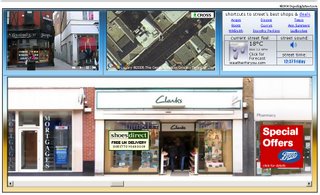
Shops advertised have links, but the comedy of this map is that it comes with the street sounds.


Nice idea, needs a bigger map (maybe with transparent buildings overlay of the shops) but made mapperz laugh. Think this would work better in Google Earth with Sketchup buildings.
maybe a suggestion is to have 'shop music' when hovering over the shop.

7/7/05 London Bombing Blasts Map - One Year On

London Bombings Map
Within just a few hours this map was created and informing people of where the blasts started and what was happening (there was alot of confusion at the time).
The site helped people find missing persons and now records the images and news of the blasts.
More information is available here.

sources: geepster and BBC News

06 July 2006

Air Quality 3D Map London

Air Quality 3D Map London
3D Map showing air quality in London

thanks to CCAblog

Community Map - London


Community Map - London with panoramic images (quicktime required.)

CommunityWalk provides a simple, yet powerful tool for mapping out:
Build your own Community Map

- How to get some place, where to park
- Location of your home or office
- Driving, walking, running, and biking routes
- Favorite bars, restaurants, museums
- The best trails, hiking spots, surf spots
- Cities, towns, and tourist attractions
- Weddings and events
- Vacations
- Real Estate
- Business intelligence
- The world around you
- Anything under the sun
Share your map with the public or keep it private.