->

31 July 2009

Free Ordnance Survey Maps for the iPhone

Free Ordnance Survey Maps for the iPhone

iOSMaps v1.0 has launched.
"Get the OpenSpace Ordnance Survey© mapping application for the iPod Touch© and iPhone© from the iTunes© Store for FREE right now!"

"The application is intended to be free, making use of newish technologies to showcase the awesome possibilities/fun of marrying different technologies. I see iOSMaps being used in replacement of paper Ordnance Survey maps. For what every your outdoor pursuit, be it mountaineering, skiing, fell running, hiking, cycling or a good old fashioned walk, just enjoy using the application on your iPhone"
Author of this application

What is looks like on screen? (minus the tile number)
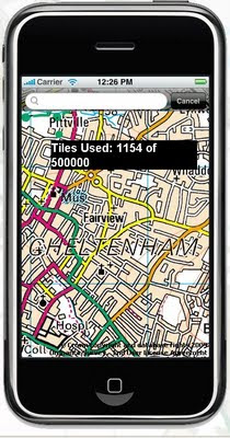
Free OS Maps iPhone
This service is not the fastest, but does work well, though you will find high data transfers costs using this service. But the idea is right, if caching of data is allowed on the phone in theory the user can 'cache os maps' before they venture out with the device.

iOSMap uses the new the mapping data provided by the OpenSpace API from Ordnance Survey, to show feature rich geographic, geotopic and cartalogic data of Great Britain. The application make use of OpenLayers, gmaps and prototype libraries and was written using the mighty iPhone sdk in Objective-C 2.0 and C.

Geeky info:
client:
iPhone/iPod Touch.

OpenLayers:Map,Control,GridProjection
OpenSpace 0.72:Map, Gazetter, GridProjection
Prototype1.6:prototype.js, scriptalicios.js
Google:gMapsAjaxSearch, googlemaps (check terms of use using google maps api and openspace api together?)

But very promising and will be the future of mapping, though not sure it will replace paper/book maps as they never run out of batteries...
Mapperz

To get the free OS Maps App on the iPhone website is:
http://www.publicfootpaths.com/

Labels: , , , , , , ,

Google Maps Flash API - 3D Perspective

Google Maps Flash API - 3D Perspective

"2-D maps are great, but sometimes it's cool to gaze into the distance. Today we're happy to announce support for perspective"

Google 3D Perspective Directions Panoramio - Flash Maps
Official Example:Driving Directions with Panoramio along a route in 3D Perspective

You can manipulate the 3D map using the same keyboard controls as you use on Google Earth and within the Maps API. Clicking and dragging moves the map in the direction being dragged, as you would expect. When dragging the map while holding down an optional modifier key, however, you can alter the attitude of the map:

  • SHIFT alters the rotation and attitude of the map around a clicked point.
  • CTRL (or the Apple key) alters the rotation and attitude of the map from the point of view of the camera.

Flash Map Google UK Weather
Ian Watkins has created this 3D perspective UK Weather Map


Keir Clarke (Google Maps Mania fame) points out to @mapperz the nice youtube video that demonstrates the flashiness of the UK Weather Map

The key and simple code to make the changes are:

Map3D.viewMode = View.VIEWMODE_PERSPECTIVE;

and replace the old position and zoom controls with the
new navigation control:


addControl(NavigationControl);
Full details and documentation
http://code.google.com/apis/maps/documentation/flash/3d-maps.html

Want even more Flash Demos
http://code.google.com/apis/maps/documentation/flash/demogallery.html

Official Blog Post and Source:
http://googlegeodevelopers.blogspot.com/2009/07/3d-perspective-in-maps-api-for-flash.html

Labels: , , , , , ,

29 July 2009

Why is Open Street Map Brilliant?

Why is Open Street Map Brilliant?

PCPRO author Jonathan Bray explains his
comment:

"The OpenStreetmap is a venture, started in 2004 by Steve Coast, similar to Wikipedia, only with maps."

"I remember looking at it three years ago and being distinctly unimpressed at the level of detail. But, it’s improved beyond recognition, with maps of London, in particular, that are just as detailed, if not more so, than Google maps. And as time goes on, its accuracy and usefulness can only increase"
But the is more to Open Street Map than you think.

Most don't know about the other projects using Open Street Map #OSM (twitter)

So here a some that have been successful

OpenSea Project
http://www.openseamap.org/


OpenRouteService
http://www.openrouteservice.org/


http://www.opencyclemap.org/


OpenStreetMap data for Garmin GPS devices
http://www.mkgmap.org.uk/page/main


Cloudmade - Customise the map colours


map styled by tripgeo development team

OpenStreetMap Static maps (early development) - please see previous post
http://mapperz.blogspot.com/2009/07/open-street-map-static-api-development.html

For more information and details (and source:)
http://www.pcpro.co.uk/blogs/2009/07/29/why-open-street-map-is-brilliant/

Labels: , , , , , ,

27 July 2009

Peak District Map (MonkeySpoon.com)

Peak District Map (MonkeySpoon.com)

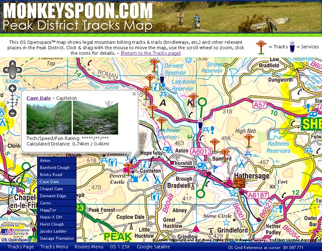
"Monkeyspoon.com guide to mountain biking tracks & trails in Peaks District"

Version 2 (using Ordnance Survey OpenSpace API) is now available and looking very good.


Peak District Map (MonkeySpoon.com)

New Features include:
  • Larger map view – The map will stretch as big as your screen goes. (Press F11 to have your browser view it full screen.)
  • Routes– Not many so far, but new ones aren’t to hard to add.
  • ‘Services’ locations – Places that useful to MTBer visiting the area.
  • Track Menu – Click to go straight to a Track.
  • Other view links – As well a link to 1:25K OS map there is now a Google Map Satellite link.
  • **Location URL shortcuts – You can link directly to a Track, Route or Grid Reference.

**How to use URL Shortcuts
"The easiest is a for a grid reference, just add “?g-” then the grid reference on the end of the URL. e.g. To go to Win Hill add “?g-SK187851” (without the quotes).
For tracks add “?t-” and the track name in lower case with dashes instead of spaces."

Direct link to the New Map
http://monkeyspoon.com/Tracks/MonkeyspoonOSopenspaceMap.htm
Original Map
http://monkeyspoon.com/tracks#osmap
Tracks Page
http://monkeyspoon.com/tracks

Labels: , , , , ,

24 July 2009

Where's Gary? Walkers Map Game Quiz

Where's Gary? Walkers Map Game Quiz

"The aim of the Game is to find Gary and give him a right clicking!"

He’s hiding somewhere in the Multimap map, and all you’ve got to do is find him.
Type in your answer to the question, click go and see if you have found Gary.
If you get stuck just click on the hints below and you’ll jump closer to his location.

When you find Gary, just click on him and then Gary will move to a new location,
where you’ll be able to look for him again.

Where is Gary Linker Map Quiz Game
Walkers Crisps and Multimap have join together to create a fun game.

Find Gary three times in a day and you can claim one ‘Gary’s Great Trips’ point.
You can boost your points total playing ‘Where’s Gary’
by one point each day.

If you’ve already claimed today’s point you can still continue to practice your Gary
hunting skills for tomorrow!

Try Finding Gary Lineker
http://explore.multimap.com/Walkers/quiz.html

or
http://www.walkers-crisps.co.uk/garysgreattrips/video/wheregary.html

Who is Gary Lineker?
http://en.wikipedia.org/wiki/Gary_Lineker
(was a good football player now a sports presenter/pundit for BBC Sport)

Promotion is by Walkers Snacks Limited

Labels: , , , , , , ,

23 July 2009

Google Maps Mobile (3.2) More Layers

Google Map Mobile (3.2) More Layers

Google Maps Mobile - More Layers
New Layers come to Google Maps for Mobile Devices

The new version, 3.2.0, adds a 'Layers' of information displayed on top of the map background to assist users to find out features and real-time incidents and transit information.

Google have updated Google Maps Mobile and there are new features such as:
  • Wikipedia Layer
  • Transit Layer - with real-time data
  • MyMaps Layer - add your own content from MyMaps.
  • Nearest features - search around your current map location.

Google Maps Mobile - Transit Layer
Layers make it easier and more useful to find and interact with geographic content, like public transit, traffic (with incidents!), local search results, Latitude friend locations, Wikipedia and more. You can also see your own My Maps content as a layer on Google Maps for mobile. And finally, multiple layers can be combined at the same time to give you a content-rich view of what's around you.

Google Maps Mobile - Wikipedia and Nearest Features

Updated Release Notes:
http://www.google.com/support/mobile/bin/answer.py?answer=156059

Related Post:
A nice roundup of the features are available from AllAboutSymbian
http://www.allaboutsymbian.com/news/item/10160_Layers_added
_to_Google_Maps_fo.php

Official Source:
http://googlemobile.blogspot.com/2009/07/layers-of-fun-in
-google-maps-for-mobile.html

Labels: , , , ,

22 July 2009

New Map of Somerset

New Map of Somerset

update:9am 22/07/09

All Points Blog debates whether this "Tube Style Map for Tourism - Does this Make Sense?"

http://apb.directionsmag.com/archives/6170-Tube-Style-Map-for-Tourism-Does-this-Make-Sense.html

Wiki Entry - http://en.wikipedia.org/wiki/Topological_map
"a map that has been simplified so that only vital information remains and unnecessary detail has been removed. These maps lack scale, and distance and direction are subject to change and variation, but the relationship between points is maintained"


"A London Tube-style map has been created detailing major tourist attractions in Somerset.

More than 100 museums, stately homes, castles, gardens, archaeological sites and railways feature on seven lines."

BBC News [Somerset]

New Topological Map of Somerset County
New topological map representing of things to do and see in Somerset.

Topographical Map of Somerset County
Traditional 'topographical representation' map of Somerset
Image Source:http://www.visitsomerset.co.uk/


"It aims to promote public access to, and interest in, the two areas’ heritage."

"the goal is to preserve, protect, promote and interpret the heritage of Somerset"

For more information go to the Visit Somerset
or visit:
http://www.youtube.com/somersetmuseums

source:
http://www.visitsomerset.co.uk/dbimgs/Somerset%20Routes%20Booklet.pdf

[pdf]
News Source:
http://news.bbc.co.uk/1/hi/england/somerset/8160773.stm

Labels: , , , , , ,

17 July 2009

Open Street Map - Static API (Development)

Open Street Map - Static API (Early Development)

"Main idea of the project is to create an web application which will provide an easy way of embedding maps into web pages. Application is going to be deeply configurable and easy to install by anyone on his server. It is being implemented in PHP5.

Mapperz first static osm map:

This an Open Street Map generated image live from the osm development server
The url that created this image is
http://dev.openstreetmap.org/~pafciu17/?module=map&center=-1.877589,50.7224&zoom=14&width=400&height=400type=cycle

Required parameters:

&center=latitude,longitude
&zoom=14 (can be 1 to 18)
&width=400 (400px)
&height=400 (400px)
type=cycle (can be mapnik, osmrender or cycle)

optional &imgType=gif or jpg (png is default)

Paths can be created (Google Maps API static maps lacks this function currently)


http://dev.openstreetmap.org/~pafciu17/?module=map&bbox=-100,45,-67,5&width=400&paths=-74,40.34,-82.3,23.1,-85,35,-87.2,32.12;-90,40,-80,40

(green is the first zigzag lines then after the semi-colon ; is the second line)


Suggestions and reporting errors:
During first month of work scaffold of application has been created with its basic functionality. Now it is time for improvements and adding new features. I would be very grateful for any feedback about API. You can send comments, information about errors etc. to osm.static.maps.api(at)gmail.com."

Mapperz has a couple of suggestions:
Can annotation be added? Like "you are here" anno=you%20are%20here;-90,180
Can polygons be added? poly=-90,180;-80,180;-80,90;-90,180&fillcolour=R255G123B0
icons - icon=basic1&3 (a circle with 3 in the middle)?

Full details
http://dev.openstreetmap.org/~pafciu17/


Your area missing map data?
Then contribute to the Open Street Map database - you be surprised how easy it is to add your own collected data. You might even get hooked like with 125,000 other osm contributors.
http://wiki.openstreetmap.org/wiki/Main_Page

Looks very promising.

Labels: , , , , , ,

16 July 2009

The Best UK Google Map API Mashup Ever?

The Best UK Google Map API Mashup Ever?

update 20th July 2009
This is now back up and running as you see it here on the blog. The Met Office reverted the code last week after this blog post
http://www.metoffice.gov.uk/invent/pwsviewer/


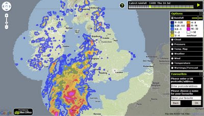
There was a sneak peak of this a few weeks ago, but the update to this is truly amazing.
This has the 'super wow' factor.

Full Credit to the Met Office on this and picking up on feedback from webs users and readers of this Mapperz Blog

Met Office - Current Weather
The Current Weather Outlook over the UK with nice clean self-explanatory icons.

Met Office - Rainfall Radar Weather
Full Radar Coverage of Current Rainfall and works smoothly in animated 'play' mode.

Met Office - Temperature Map Weather
Now with the Mapperz most requested overlay - temperature - users can use the slider on the legend to adjust the opacity (transparency) of the overlay.

Met Office - Wind and Direction Map Weather
Wind speed and directions now available - clear icons with more information on hovering over the icons.


Met Office - Weather Warnings Map title=
Weather Warnings illustrated by counties across the UK

The Met Office Weather Map- Enjoy!
http://www.metoffice.gov.uk/invent/pwsviewer/
17/07/2009
update Bad Weather stops play.
"reverted until we get over this weekend's severe weather event."
so come back next week.
Well done too all involved a great service just got better (Next week).
(special thanks to @angerelle)

Note Firefox users with FireBug might experience the no map issue - either disable firebug or use another browser to view this map, its worth it for the experience.
(this is fixed!)

Related Post
http://mapperz.blogspot.com/2009/06/met-office-google-maps-weather.html

Follow Mapperz on Twitter

Labels: , , , , , , ,

13 July 2009

Cartagen (0.5) - OSM Cartographic Mapping - New!

Cartagen (0.5) - OSM Cartographic Mapping - New!

Newly release of the dynamic mapping framework Cartagen.

"In this release, we’ve taken a shot at rendering any location on the planet (drawing, of course, on data from OpenStreetMap), and at rendering a much greater density of map features with richer styles. The has come a long way, and we hope it makes designing your own map easier while allowing even greater possibilities for unique and compelling designs."


Take 6 minutes to learn how to download, set up and customise OpenStreetMap vector data.
Very informative video.
Credit to Jeff Warren and Ben Weissmann

More information and setup instructions are on Cartagen’s wiki, and our live demonstration site at cartagen.org has been updated.

Suggestion: As mentioned on the Mapperz Cloudmade post.
"Reorder Layers, ranking structure - sometimes having polygons above features can be useful, like a masking out polygon."

More Information
Getting Started
http://wiki.cartagen.org/wiki/show/GettingStarted
Source:
http://unterbahn.com/2009/07/announcing-cartagen-0-5/

and the main site: http://cartagen.org/ where data can be downloaded (json format)

Downloads
http://code.google.com/p/cartagen/downloads/list

@mapperz

Labels: , , , , ,

10 July 2009

Live Traffic Reports Google Maps (Los Angeles)

Live Traffic Reports Google Maps (Los Angeles)

"The Los Angeles region is widely known for its extreme traffic, and a study released just this week by the Texas Transportation Institute reports that LA has the most significant congestion in the United States. It goes on to estimate that commuters in LA spent 485 million hours idling in traffic, wasting 367 million gallons of gas."
(hint: have a smaller engine or get on a bus)

Google Maps Live Traffic Reports LA
Go to Google Maps (in Los Angeles) and hit Traffic and you get real-time incidents mapped.
A click-able icons and informative data to help advise on an alternative route.


The LatLng Blog Highlights the Los Angeles Traffic and Transit issues

"However, Los Angeles also has an extensive public transit network, operated by the Los Angeles County Metropolitan Transportation Authority (Metro), and today we're excited to introduce them as the newest addition to Google Transit. Metro operates 5 rail lines and nearly 200 bus lines within Los Angeles County, logging an average of 1.5 million weekday boardings."

"As a part of Google Transit, Metro's itineraries will now appear as an alternative with the "Public Transit" link when a user searches for driving directions within their service area to remind commuters of the availability of public transit. Turning on the Traffic layer in Google Maps to get an idea of what congestion awaits may provide even more motivation to try take advantage of Metro!"
http://google-latlong.blogspot.com/2009/07/take-ride-with-la-metro-in-google.html
(and source)

How useful is this?
Well being real-time and accurate it seems to work extremely well. If only all cities made this data available then the amount of fuel consumption and wasted hours in traffic could be reduced.
Well done Google and the Los Angeles County Metropolitan Transportation Authority for making it available for the public.

Labels: , , , , ,

09 July 2009

Ericsson Web & Mobile Maps API (Labs)

Ericsson Web & Mobile Maps API (Labs)

Use Web Maps to embed powerful and flexible maps into your web applications.

  • Powerful map component easily embeded into any web page
  • Custom layers with your own objects and symbols
  • Embedded Java Applet with dynamic map rendering in the browser
  • Easily integrated Javascript interface
  • Automatic fall back to Javascript only version for browsers that doesn’t support Java Applets
  • Free access to map data (TeleAtlas - Vector data)

Ericsson Web Maps - Java

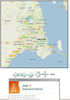
The Ericsson Web Maps API (Labs) uses Java for the mapping (javascript- fallback if no java available), first load can be a little slow at times.

Working Example

http://saudi.betainnovation.com/controls.html

Web Maps provide dynamic maps which you can integrate into any web application and features a large variety of control possibilities and overlay of symbols. The maps are rendered in a Java Applet which provides fast map browsing and smooth and animated interaction.

The dynamic rendering also let’s you control the look and feel of the map and how your users interact with it.

Currently limited in Mapping Examples. Users would be encouraged to create their own.

More information on the Web Maps API:

https://labs.ericsson.com/apis/web-maps/documentation

Mobile Version (also with an API)

"Mobile Maps is Java based and available both for Java ME and for Android. You download the Java ME or Android library, which provide the functionality of downloading, displaying, and interacting with maps to your applications. It also includes access to the map data itself."

Key Point with the Mobile Maps Version is:
"Through its unique functionality of rendering the maps in the mobile phone application Mobile Maps use very low bandwidth in comparison to many other map services and applications."

Mobile Maps is powered by Idevio and Tele Atlas


More information
https://labs.ericsson.com/apis/mobile-maps/

Source: (Also mentions the new SMS Send & Receive API)
http://blog.programmableweb.com/2009/07/04/5-new-apis-sprint-ericsson-and-volunteerism/

Labels: , , , , , , , ,

07 July 2009

Land of Britain | Map Viewer (Historical)

Land of Britain | Map Viewer (Historical)

Update: 08/07/09

Looking for Vision of Britain Maps?
"A vision of Britain through time - Including maps, statistical trends and historical descriptions"
Vision of Britain - Historical Maps
Mapping includes:
  • Topographical Maps
  • Land Utilisation Maps
  • Administrative Maps
http://vision.port.ac.uk/maps/
(hint:click bigger map)

Update: 4pm [07/07/09] The BBC have created a video on this mapping application (hopefully all users can see the video not just UK users)
http://news.bbc.co.uk/1/hi/england/8138486.stm

"The Land of Britain web site was created by the
Great Britain Historical GIS Project, based at the University of Portsmouth, with funding from the Frederick Soddy Trust.
A Vision of Britain through Time (new site) covers the whole of Britain, but not at this level of detail."

More information on this can be found here
A GENERAL INTRODUCTION TO LAND USE MAPPING IN BRITAIN
http://riga.iso.port.ac.uk/django_projects/doc/pamphlet/chapter1/

Land of Britain 1800's Brighton & Hove
The First Edition Maps, dating back to the 1800's

"We are deeply grateful to Rex Walford, director of the Land Use UK Survey, for letting us draw on the teacher's pack he created with Tony Binns, featuring Brighton area maps from the 1960s and 1990s survey, and to the copyright holder for the Land Utilisation Survey of Great Britain for allowing us to re-publish Dudley Stamp's maps. We thank the British Library of Political and Economic Science for scanning the Stamp field survey sheets, and the British Library for scanning the Ordnance Survey First Series sheet."


A GENERAL INTRODUCTION TO LAND USE MAPPING IN BRITAIN
http://riga.iso.port.ac.uk/django_projects/doc/pamphlet/chapter1/

The Historical Maps overlayed together using opacity side-bars can show users the urbanisation of Brighton and Hove over many years.


Land of Britain 1934 Brighton & Hove
More recent (1934) colourful maps show the large development along the coastal towns

Land of Britain 1967 Brighton & Hove
Full colour, largescale highly detailed mapping (1967) of Brighton & Hove. Showing the full and large urbanization sprawl of the town and city

The Map Viewer
http://riga.iso.port.ac.uk/django_projects/maps_full/

Full Acknowledgments
http://riga.iso.port.ac.uk/django_projects/info/

Openlayers was used to develop this Mapping Application

Source:
http://www.craigbellamy.net/2009/07/07/a-vision-of-britain-through-time/

Labels: , , , , , , , , ,

06 July 2009

US National Weather [RADAR] Animated

US National Weather Animated

"A very good visual way to mix Openlayers and Google Maps with near real-time Radar information"

US National Weather Service Animated
Animated Weather and Hazard Warning (Fire Risk, Flash Flooding etc)
Very Smooth and Animates in near real-time over the next 24hrs

Speed of animation can be controlled as is the Opacity of the overlays.

Individual Weather Monitoring Stations can also be displayed

South Dakota Flood Warning

At the time of this post South Dakota has Flood warnings across the state
http://radar.srh.noaa.gov/?zoom=3&lat=43.8511&lon=-98.4131&layers=B000TTTTTTTT

Feedback Survey - Good to see they want feedback from users

http://www.weather.gov/survey/nws-survey.php?code=RIDGEII


KMZ Overlays for Google Earth (and Other KMZ accepting applications)

"While the RIDGE radar display allows for the use of interactive toggles with the image, RIDGE images can be best utilized with GIS software. This page allows you to create "kmz" files which are compressed "kml" files compatible with several GIS software applications"

http://radar.weather.gov/ridge/kmzgenerator.php

UK Met office related post (take note UK MET OFFICE ;)
http://mapperz.blogspot.com/2009/06/met-office-google-maps-weather.html

Labels: , , , ,

03 July 2009

GlobalMapper v11 (Beta1) now with OpenStreetMap

GlobalMapper v11 (Beta1) now with OpenStreetMap

"Global Mapper just got even better."

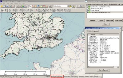
Global Mapper v11 (beta1) with Open Street Map
Open Street Map as a background layer note: OSM Rasters are projected on the fly to British National Grid in this case.
But very useful now the Digitising Tool is updated and dock-able (also shown)


One of the best and affordable GIS software packages around just got a lot better.

Global Mapper v11 (beta1) now introduces OpenStreetMap as background layer for your map projects, It is also available to capture your own content.

New Features: summarised as the list is way too long

- Added free built-in access to global street-level maps from OpenStreetMap.org via the File->Download Online Imagery menu command.
- Added real-time display of current cursor information (location, distance, elevation) to 3D Path Profile dialog. In addition, you can now also click to define a sub-path on the 3D Path Profile dialog and get information about that sub-path displayed.
- Added support for scaling point symbols, adding custom point symbols from PNG, GIF, and JPG files, and easily creating symbols of custom sizes and colors for common shapes, like dots, squares, etc.
- Added toolbar for Digitizer/Edit Tool to make it easier to perform many commonly used operations.
- Added ability to create new line features by tracing them without clicking at each vertex with the Digitizer/Edit Tool.
- Added ability to rotate and scale features using the Digitizer/Edit Tool.
- Added support for numerous new formats, including Vertical Mapper (MapInfo) Grid, QCT, QED, HTF, SPS, BAG, and many others.

All of the other numerous changes are listed in the What's New document that is displayed during installation.

Prior to the v11.00 release we also plan on adding several other major features, including a map layout tool for more easily creating finished maps, PDF export, DWG export, access to better world-wide imagery, support for combining area features, and support for exporting new multi-band files.

Please visit this forum for the latest new and link to the download
A great way to allow many users to comment on new features and find potential bugs before a full released version
Download Global Mapper 11 (beta1) from here: (Includes
full version for a limited number of days '15th July 2009')
There is also a 64-bit version of Global Mapper for 64-bit versions Windows
http://www.globalmapperforum.com/forums/announcement-news/4301-global-mapper-v11-00-beta-1-now-available.html

GlobalMapper v11 with be officially released v11.00 in approximately 1 month.

Unregistered Versions do work with this software though you will not be able to export data or overlay more than 4 layers of data. But for the price $349 or $129 (upgrade from v10) you get a lot features for your money.

Well done to the GlobalMapper Team always surpassing expectations.

New Related Post:
In addition there is a very good blog post showing you how to make your own customised maps/imagery for bing maps
http://www.soulsolutions.com.au/Blog/tabid/73/EntryId/610/Getting-your-custom-imagery-onto-Bing-Maps-with-Global-Mapper-and-the-Cloud.aspx

Labels: , , , , , ,

02 July 2009

OpenFlights - Route Mapping The World

OpenFlights - Route Mapping The World

OpenFlights is a tool that lets you map your flights around the world, search and filter them in all sorts of interesting ways, calculate statistics automatically, and share your flights and trips with friends and the entire world (if you wish). It's also the name of the open-source project to build the tool.

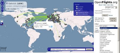
OpenFlights Routes Across the World

Search by Click the Icons on the Map or Airport Code, Airport Name or IATA Name- a very handy Aiport Map. Mapping base by OpenLayers

Note: Now, you can click on any airport and see every single scheduled flight:

Testing Stages:

OpenFlights has been going through Alpha, Beta and Gamma test phases, OpenFlights is now in its Delta phase: all core functionality is implemented, but development on new features continues. If you'd like to be informed about major updates to the site visit their blog


OpenFlights Routes Official Example

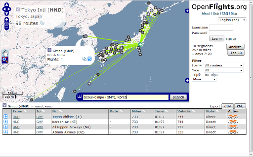
For easy access to this, we’ve added a Quick search widget, shown expanded above but normally hiding in the bottom-right corner under the icon. Here’s how to use it, in two easy steps:

  1. Enter the airport name, city or IATA code in the box. OpenFlights will automatically suggest matches as you type, and if the airport is already shown on the map, OpenFlights will pop it up.
  2. Once you’ve entered a valid name, the Search button becomes active. If you click on this, OpenFlights will load a route map showing all flights from that airport.

But there’s more! In the popup for every airport, there’s now a Routes button, which you can also use to see the map. If you click on the List button for the mapped airport (via popup or the top left corner), you’ll get a list of all flights operating from there; if you click on that button for another airport, you’ll get a list of all airlines connecting the two, even including codeshares.

Source and Image:

http://openflights.org/blog/2009/06/26/route-mapping-the-world/

Visit the OpenFlights Route Map


Labels: , , , , ,