->

30 March 2011

Travel Times Paris - OSM

Travel Times Paris - OSM

Find Travel Times in Paris using http://www.isokron.com/


(lower quality Blogger video - but faster)

You can also add an additional point to find the best (fastest) location to meet up half way with a friend.


(Higher Quality Video via You Tube - Slower)

Map Base is Open Street Map and Isocron Mapping

Labels: , , , ,

30 December 2010

OpenTripPlanner Portland

OpenTripPlanner Portland

A trip planner with a difference

"A trip planner helps you figure out how best to get where you want to go. A multi-modal trip planner lets you plan routes using multiple "modes," for example, on foot, bike, train, bus, or some combination thereof. A good multi-modal trip planner allows you to easily tailor your trip to your preferences, for example by eliminating transfers, walking a more scenic path, or only riding buses with bike storage."

What is OpenTripPlanner?

OpenTripPlanner is an open source multi-modal trip planner. It brings together work from a number of existing open source projects, including Graphserver, OneBusAway, and FivePoints, and aims to be easy-to-use, flexible, reliable, and fast.

OpenTripPlanner Portland
Planning a trip is very straightforward - right click to create start point and right click to add destination.
OpenTripPlanner Portland Route
Lots of Options - like Transit only - with changes includes - clearly laid-out.


For Developers
  • Plans true multi-modal trips combining walking, biking and transit
  • Plans wheelchair accessible trips
  • Plans depart by/arrive by trips
  • Takes road type, bike lane, and elevation data into account when planning bike trips
  • Show elevation maps for bike trips
  • Imports data from GTFS, shapefiles, OpenStreetMap, and the National Elevation Dataset
  • Plans trips in about 100ms in a moderate sized city
  • Exposes a RESTful API (XML and JSON), which other apps or front-ends can build on

Try the OpenTripPlanner for Portland
http://maps5.trimet.org/otp/

wiki for developers
http://opentripplanner.org/wiki

Labels: , , ,

30 November 2009

OpenSteetMap Potlatch 2 Development Preview

OpenSteetMap Potlatch 2 Development Preview
"It's not just an online map editor - it's a Live Cartographic Online Editor"
Potlach 2 Editor

OpenStreetMap users are getting a brand new online 'cartographic' editor in the form of Potlatch TWO (2.0)
Potlatch 2 is a complete rewrite.

Aim:

  • Speed

  • Ease-of-use

  • Flexibility

Four big new features :

1.New feature – friendly tagging system Potlatch 2 has a friendly, intuitive tagging system. The mapper can use graphical menus, dedicated fields, and icons to get the tagging just right – without the need to remember tag names and values.

Graphical Presets - no need to lookup or remember tags

Potlach 2 has a friendly, intuitive tagging system. The mapper can use graphical menus, dedicated fields, and icons to get the tagging just right – without the need to remember tag names and values.

2.New feature – 'What You See Is What You Get' (WYSIWYG) rendering Potlatch 2 has an all-new rendering engine far in advance of the current one.
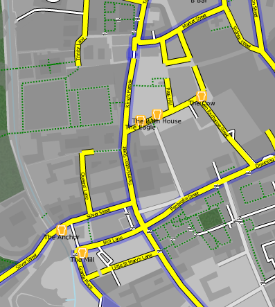

Potlach 2 Editor MapCSS


source:http://www.opengeodata.org/2009/11/30/introducing-a-new-osm-editor-potlatch-2/
With road names, patterned fills, rotated icons, and much more,form a Cartographic editing experience can be like working live on the familiar Mapnik rendering, the cyclemap, Osmarender, or anything you like -making it much more approachable for the beginner.Thumbs ups for this!

3.Cascading Style Sheets - CSS but for Maps = MapCSS


Just like the tagging, the rendering is easy to customise. It uses a special form of CSS, called MapCSS, which lets you create wonderful-looking maps with just a few lines of text. The tagging and rendering together make Potlatch 2 ideal for ‘vertical’ mapping applications, such as a cycle-specific editor or a building/addressing editor. Stylesheets aren’t just about making the map look pretty: you can create stylesheets to help your mapping, such as one that highlights roads without names.
So if your only interested in Footpaths then only show footpaths


Because this integrates fully with MapCSS stylesheets, you can choose to temporarily hide background data, or show (say) only footpaths… whatever you like.

So Potlatch 2 will have an accompanying ‘OSM Guide’, explaining the basics with friendly, illustrated text. It will be concise, focused and clear.

4.New feature – vector background layer Mappers are working more and more with imports. But the approach until now has been to import data directly into the map – and many people have pointed out the problems this can lead to.Highly requested


Potlatch 2 will support vector background layers.

You can load OSM-formatted data from servers or files, and work on bringing it into the map the way you want, at your own pace.
Fully rewritten in ActionScript 3 Potlatch 2 is written in ActionScript 3, a Java-like language with an open source compiler and full docs available online. The Potlatch 2 source comes with instructions on getting started and is, of course, permissively licensed under the WTFPL.
Potlatch 2 thus far has been written by Dave Stubbs and Richard Fairhurst (Great Work). But we would love to see more people hacking on the source. There’s a potlatch-dev mailing list especially for this.

New Existing Features likely to be coming:
Some other features, like Yahoo and tiled backgrounds, are finished but not currently exposed through the editor: they’ll be along shortly. Others, such as GPS track support, the Beginners’ Guide and the vector background layer are not coded yet but are intended for the initial release.Load Import Shapefile? Export Shapefile options?? Would be good. [Hint]


Potlatch 1 has some three years of development behind it, of course, and much of this feature set has not yet been ported to Potlatch 2. There’ll be countless little UI tweaks (no keyboard shortcuts yet, for example!); and as you’d expect for an in-development version, performance can sometimes be sluggish and there’s a lot of optimisations we’d like to do.
But with work progressing so fast, this seemed a great time to talk about it. Both the tagging system and the renderer are enormously flexible and we’d like to see people hacking on them as soon as possible.
Live Version
at:http://www.geowiki.com/potlatch2/
Renderer alone at:
http://www.geowiki.com/halcyon/

Should you want to try a particular area, just put the lat and lon in the URL like this:


http://www.geowiki.com/potlatch2/?lat=52.2&lon=0.1http://www.geowiki.com/halcyon/?lat=52.2&lon=0.1

Source Code is at:http://trac.openstreetmap.org/browser/applications/editors/potlatch2

More on MapCSS and documentation at:http://wiki.openstreetmap.org/wiki/MapCSS

Full Credit and Original Post
http://www.opengeodata.org/2009/11/30/introducing-a-new-osm-editor-potlatch-2/

Labels: , , , , , , ,

14 November 2009

Advantage West Midlands Using OpenStreetMap

Advantage West Midlands Using OpenStreetMap

One of the first commercial enterprises to fully take on 'crowdsourced' maps
A huge boost to OpenStreetMap

Open Street Map West Midlands ICT - AWMist

Advantage West Midlands is the regional development agency (RDA) for the West Midlands. We are one of nine RDAs in England established to transform the English regions through sustainable economic development.

AWMist (A Web Map-based Information Search Tool)
AWMist has data about ICT and electronics businesses, about public sector supporting projects and services, about universities and their research groups, and about private sector professional services and training organisations from the West Midlands.

The purpose of AWMist is to encourage and foster collaboration between businesses, universities, local, regional, national and transnational agencies and organisations by greatly increasing the speed and ease by which organisations can easily identify potential partners and business opportunities.

West Midlands chose a solution based on OSM for its more open commercial terms and lack of technical restrictions when compared to rival map providers. The fact that the data for the West Midlands was collected and maintained locally was also a factor in the decision.

quote:
"One more example Open Source, GIS and Open Street Map in particular making a difference in this highly competitive world."

source:
http://www.openstreetmap.org/user/brianboru/diary/8617#comments

Labels: , , , , ,

15 October 2009

Atlanta Mapathon - Creating the Best Mapped City

Atlanta, the capital of the US state of Georgia will soon be the world's most digitally mapped city, according to organisers of a massive "Mapathon".
Source: BBC News

OSM Map Altanta Mapathon

http://www.openstreetmap.org/index.html?lat=33.792&lon=-84.336&zoom=10

What is a Mapathon?
Mapping on-mass [crowdsourcing] the downtown Atlanta area including parks, university campuses and historic sites. Volunteers will be on hand to help new mappers learn how to use a GPS or Walking-Papers and have helpful tips for beginners. Come for the whole day or just stop by for an hour to learn the basics of community mapping and add a few points of interest to the map.

Atlanta Citywide Mapathon

October 16th 17th 18th

During this three day mapping event, local businesses, community groups and OSM members will join together to launch a citywide initiative to help make the map of Atlanta one of the best in the US. For details of how to get involved in this fun, family-friendly event, see the Atlanta Citywide Mapathon page.

Useful links:
http://wiki.openstreetmap.org/wiki/Atlanta_Citywide_Mapathon
http://wiki.openstreetmap.org/wiki/Atlanta#Atlanta_Citywide_Mapathon

New to OpenStreetMapping?
http://wiki.openstreetmap.org/wiki/Beginners%27_Guide

Labels: , , , , , , , ,

09 October 2009

OpenStreetMap Formula 1 Circuits

OpenStreetMap Formula 1 Circuits

F1 OpenStreetMap Circuits
OpenStreetMap Formula 1 Circuit - Circuit de Monaco (Monaco)

OpenStreetMapper '

Labels: , , , , , , , ,

11 September 2009

MapOSMatic - Free Street Map Index Generation

MapOSMatic - Free Street Map Index Generation

**for France only but is hoping to expand in the near future.

Combining the OpenStreetMap mapping platform with Postgres (using PostGIS Functions) for creation of 'Bingo' grid maps with street indexes.

Example
Chavagne Open Street Map - MapOSMaticChavagne Map Index - MapOSMatic
source: http://www.maposmatic.org/smedia/chavagne.png
http://www.maposmatic.org/smedia/chavagne_index.png
(large .png's some web browsers can choke on image size being large)

This makes it very useful to print and use on your travels or to help OpenStreetMap fill in any missing or changed names - you can contribute here with over 135,000 budding OSM'ers.
Note: you don't have to have a GPS device to contribute.
Paper and Pencil works! (see http://walking-papers.org/)

How does this work? (techie stuff bit)
  • Renders the map using OpenStreetMap data and the OpenStreetMap Mapnik stylesheet;
  • Renders on top of the map, using Mapnik, the grid of 500 meters squares, the labels of the squares, and a few other informations on the map (copyright, scale, etc.);
  • Greys out all the area outside the city if we find its administrative boundary;
  • Renders an index of the streets, based on OpenStreetMap data and the intersection of the streets with the squares on the map.
"On our server, we run a PostgreSQL server, with the PostGIS extension. In this PostgreSQL server, we have loaded the full OpenStreetMap data for the metropolitan France, using the dumps from Geofabrik and the osm2pgsql tool."

This web service has been called MapOSMatic, like map-o-matic but with a reference to OpenStreetMap (OSM). The web service is written in Python using Django. It is responsible for storing the rendering requests and displaying the result of these requests. The rendering itself takes place asynchronously through the maposmaticd daemon. This daemon does only one rendering at a time, which is very important because of the CPU and I/O intensive nature of the map rendering process.

If you would like to contribute to this project then more information is available:
http://www.maposmatic.org/about/

Mapperz looks forward to it expanding across the rest Europe and the rest of the World.

Labels: , , , , , , ,

29 July 2009

Why is Open Street Map Brilliant?

Why is Open Street Map Brilliant?

PCPRO author Jonathan Bray explains his
comment:

"The OpenStreetmap is a venture, started in 2004 by Steve Coast, similar to Wikipedia, only with maps."

"I remember looking at it three years ago and being distinctly unimpressed at the level of detail. But, it’s improved beyond recognition, with maps of London, in particular, that are just as detailed, if not more so, than Google maps. And as time goes on, its accuracy and usefulness can only increase"
But the is more to Open Street Map than you think.

Most don't know about the other projects using Open Street Map #OSM (twitter)

So here a some that have been successful

OpenSea Project
http://www.openseamap.org/


OpenRouteService
http://www.openrouteservice.org/


http://www.opencyclemap.org/


OpenStreetMap data for Garmin GPS devices
http://www.mkgmap.org.uk/page/main


Cloudmade - Customise the map colours


map styled by tripgeo development team

OpenStreetMap Static maps (early development) - please see previous post
http://mapperz.blogspot.com/2009/07/open-street-map-static-api-development.html

For more information and details (and source:)
http://www.pcpro.co.uk/blogs/2009/07/29/why-open-street-map-is-brilliant/

Labels: , , , , , ,

17 June 2009

Open Street Map & FireFox 3.5 (RC1) Geolocation

Open Street Map & FireFox 3.5 (RC1) Geolocation

update 30th June 2009
FireFox 3.5 is officially released
http://www.mozilla.com/en-US/firefox/all.html

FireFox 3.5 Download Visualization Map (& Stats)
http://downloadstats.mozilla.com/

Question where is Geolocation support in Firefox 3.5?

TOOLS>PAGE INFO> PERMISSIONS> Share Location

@Mapperz original post:

FireFox 3.5 (RC1) now has Geolocation built-in this has very distinct advantages.
"Websites that use location-aware browsing will ask where you are in order to bring you more relevant information, or to save you time while searching. Let’s say you’re looking for a pizza restaurant in your area. A website will be able to ask you to share your location so that simply searching for “pizza” will bring you the answers you need... no further information or extra typing required."

An important note privacy:

"When you visit a location-aware website, Firefox will ask you if you want to share your location.

If you consent, Firefox gathers information about nearby wireless access points and your computer’s IP address. Then Firefox sends this information to the default geolocation service provider, Google Location Services, to get an estimate of your location. That location estimate is then shared with the requesting website.

If you say that you do not consent, Firefox will not do anything."

Okay this a mapping blog and here the best FireFox 3.5 (RC1) Geolocation Example: On a map.

OpenStreetMap - Geolocation using Firefox 3.5 RC1
In Firefox 3.5 (RC1) you will be prompt to 'share location' allowing
will enable the geolocation tool.
Here map quickly finds the IP address and geocodes this returning the map for your ISP.
This then starts bringing up an OpenStreetMap with wiki poi & placenames (from geonames.org)

Here is the link to that Geolocating map (Geolocation will only work if your using FireFox 3.5)
http://3liz.org/geolocation/ (well done 3liz.com)

Mapperz

Labels: , , , , ,