->

01 April 2011

OpenWhatEverMap

OpenWhatEverMap

'An Open Awsumnez Map'

http://openwhatevermap.org/

Labels: , , ,

30 March 2011

Travel Times Paris - OSM

Travel Times Paris - OSM

Find Travel Times in Paris using http://www.isokron.com/


(lower quality Blogger video - but faster)

You can also add an additional point to find the best (fastest) location to meet up half way with a friend.


(Higher Quality Video via You Tube - Slower)

Map Base is Open Street Map and Isocron Mapping

Labels: , , , ,

14 January 2011

ABC Community Queensland Flood Map

Updated: 14/01/2011 6.10pm
The ABC has launched an interactive map of the Queensland flood. Please 'Submit a Report' about what's happening in your area. The map includes both verified and unverified reports. Please note, this is an experiment in gathering information from the community.

ABC Community Queensland Flood Map
It works like this: you send us information, either by email (qldfloodsmap@gmail.com), text message or Twitter (simply use the #qldfloodsmap hashtag on your post) .

More Information
http://queenslandfloods.crowdmap.com/main

Map
http://queenslandfloods.crowdmap.com/


ESRI have also released "ESRI Australia - Brisbane City Council Flood COP - Situational Awareness Application"
Australia ESRI Flood Map
http://www.esri.com/services/disaster-response/australia-flooding-map-2011/response-map.html

Labels: , , , ,

07 January 2011

#ukfuel Bing Maps

#ukfuel Bing Maps

#ukfuel Bing Maps

Same concept as Ben Marsh's http://uksnowmap.com/ but with UK fuel prices and UK Post Codes and twitter mapped out on Bing Maps

The format of #ukfuel tweets is as follows:
[postcode] [fuel type] [price]

For example:

DA16 UL £1.30

http://www.scottlogic.co.uk/blog/colin/ukfuel-a-twitter-bing-maps-mashup-for-tracking-fuel-prices/

cross-posted from http://bingmapswatch.blogspot.com/

Labels: , , , , ,

17 November 2010

Cornwall Flooding - November 2010

Cornwall Flooding - November 2010

Cornwall Flooding November 2010

Submit a Flooding Report
Cornwall Flooding November 2010 Submit


About This Project

"This is an experimental project created by BBC Cornwall to map reports of the floods. We will add our reports but we'd love you to add your experiences and your tips for helping the community."

You can submit a report by:

a) Sending an email to radio.cornwall@bbc.co.uk

b) Sending a tweet with the hashtags #cornwall #flood or #floods

c) Filling in the form on this site http://cornwallfloods.crowdmap.com/

When you send your reports or comments, they will be put up on the map.


http://cornwallfloods.crowdmap.com/

Labels: , , , ,

31 August 2010

The Future of Mobile Maps - Upnext

The Future of Mobile Maps - Fluid Mapping from Upnext

Today Upnext have launched their new iPad app with Fluid Labels.


Seamless integration with 3D Mapping, Map Overlays, real-time content.

The label system is now optimized for the iPad size. When you perform a search, multiple results populate the screen. As you move around the map, the results, smartly, refresh to give you more venues.

Category search or try using the Foursquare Friends checkins to really see the labels in action.

There are a couple more changes in this version. The Venue Info window has been enlarged and reformatted. Editorial and user reviews are now spread out in an elegant layout.

source:
http://techcrunch.com/2010/08/30/upnext-ipad-fluid/

Labels: , , , ,

17 August 2010

BBC Dimensions (Prototype) Mapping

BBC Dimensions (Prototype) Mapping

BBC Dimensions is an experimental prototype for the BBC. We want to bring home the human scale of events and places in history. The D-Day landing beaches measured from London to Norfolk in the UK. How far would the Titanic stretch down your street?

"Dimensions simply juxtaposes (side by side) the size of historical events with your home and neighbourhood, overlaying important places, events and things on a satellite view of where you live. Certain "Dimensions" can be transformed into short walks, so you can get a physical appreciation of the distances involved."


BBC Dimensions howbigreally map
Use your Postcode or Town to recenter the map and see in scale terms historical events with this map tool.

How do you make the Dimensions maps?

We've built a system that can quickly take scale illustrations of historical events and superimpose them on zoomable, clickable maps. Information designers at the BBC research and produce these illustrations based on a range of library and on-line resources to make them as accurate as possible. If you think it got something wrong, get in touch. http://howbigreally.com/contact/

BBC Dimensions example maps

More Examples of events across the globe are available.

Can I make a Dimensions map?

The BBC hope to open up the ability to create Dimensions maps in a future version, so that local historians, experts and enthusiasts can use it as a tool for communicating what they know.

What's next for Dimensions?

BBC will evaluate the prototype based on your feedback, and hopefully integrate it into the BBC's online history and news coverage

Try the BBC Dimensions (Prototype) Mapping

http://howbigreally.com/

Labels: , , , ,

28 June 2010

Download ESRI ArcGIS 10 - Released

Download ESRI ArcGIS 10 - Released

Finally ArcGIS 10 has put the 'E' back in Environmental Systems Research Institute

updated: 21:38 BST 28th June 2010.

Read the Requirements before thinking of downloading

"ESRI (UK) is pleased to announce that ArcGIS® 10 will be available shortly. ArcGIS 10 will revolutionise how organisations use geographical data and delivers a host of new possibilities."

"The ArcGIS 10 software will be available as a download from week commencing 28 June or on DVD at a later date." [But when?]

Users with a maintenance plan can download the software (3.2GB +8.0GB for ArcGIS 10 Data)ESRI ArcGIS 10 Released - Downloadable

ESRI UK has re-vamped their site to include ArcGIS 10 (not just re-directing to the US site)

Here are the links (note: don't try downloading whilst viewing videos unless have a super-fast broadband connection)

ArcGIS 10 Demos:

Introduction to ArcGIS 10
Usability Enhancements (10 usability enhancements in ArcGIS Desktop)
3D in ArcGIS 10 (display, analyze, and maintain 3D data in ArcGIS 10)
Enhanced Map Editing (enhanced map editing tools and workflows)
Modeling and Analysis (more productive, access data faster, and generate better models and results)
Mapping Workflows ( create, manage, and share your maps more efficiently)
Production and Automation (Python window in ArcGIS 10 MapBook, Sharing)

UK Users of UK Specific Products

UK Product Compatibility Status

ProductCompatibility Date
ProductivitySuiteJuly 2010
CrimeAnalystAugust 2010
LocalView FusionAugust 2010
LocatorHubSeptember 2010
http://www.esriuk.com/arcgis10/existing_customers.asp
Full Product list

Please note the web browsers below are supported for the ESRI Customer Care Portal from which our customers will download ArcGIS 10
Internet Explorer: version 6+
FireFox: all versions
Chrome: all versions
Safari: all versions
Opera: 9+
Additionally users will need Flash Player 9+ installed and JavaScript enabled to use the site.

FILE SIZES - BIG
Product LineProducts Available for DownloadFile Size (approximate)
ArcGIS DesktopArcGIS Desktop 103.2 GB

ArcReader 101.6 GB

ArcGIS Desktop Tutorial Data 102.0 GB

ESRI Data & Maps for ArcGIS 108.0 GB


ArcGIS Server EnterpriseArcGIS Server Enterprise 10 for Windows3.0 GB

ArcGIS Server Enterprise 10 for Red Hat Linux Enterprise and SUSE Linux Enterprise3.2 GB

ArcGIS Server Enterprise 10 for Sun Solaris on SPARC3.2 GB

ArcSDE 10 for Windows1.0 GB

ArcSDE 10 for UNIX2.5 GB

ESRI Data & Maps for ArcGIS 108.0 GB

ESRI Data & Maps for ArcGIS Server 108.0 GB


ArcGIS Server WorkgroupArcGIS Server Workgroup 103.5 GB


ArcGIS Engine Developer KitArcGIS Engine Developer Kit 10 for Windows2.6 GB

ArcGIS Engine Developer Kit 10 for Red Hat Linux Enterprise and SUSE Linux Enterprise and Sun Solaris on SPARC2.75 GB

ArcGIS Engine Runtime 102.6 GB


ArcGIS Engine RuntimeArcGIS Engine Runtime 102.6 GB


ArcIMSArcIMS 103.4 GB

ArcIMS Gazetteer0.65 GB


ArcInfo WorkstationArcInfo Workstation 10 for Windows & Sun Solaris on SPARC1.9 GB


ArcGIS Image ServerArcGIS Image Server 100.50 GB


ArcGIS Workflow ManagerArcGIS Workflow Manager 100.07 GB


ArcGIS Server Workflow ManagerArcGIS Server Workflow Manager 100.08 GB


ESRI Mapping and Charting SolutionsESRI Production Mapping 100.25 GB

ESRI Aeronautical Solution 100.35 GB

ESRI Defense Mapping 100.40 GB

ESRI Nautical Solution 100.35 GB


ArcGIS Data ReviewerArcGIS Data Reviewer 100.10 GB


Tracking ServerTracking Server 100.50 GB


ArcPadArcPad 100.20 GB

ESRI StreetMap Premium Tele Atlas North America (USA and Canada)2.0 GB

ESRI StreetMap Premium Tele Atlas Europe3.0 GB
US Site:

Labels: , , , , ,

04 March 2010

SaferMK Community Safety Mapping by Zubed

SaferMK Community Safety Mapping by Zubed

A nice web GIS mapping solution....

SaferMK Community Safety Mapping by Zubed
Overlay of Crime data using Openlayers and using Ordnance Survey Mapping from the GetMapping Map Service

Clear thematic data is overlayed and fully interactive to query online but importantly easy to use by non-gis users (key fact!)

SaferMK Community Safety OS 25k Mapping by Zubed
1:25,000 Ordnance Survey (Explorer range) is used - making buildings and rights of way information viewable - you don't see this level of detail online often.

**Hopefully after the Ordnance Survey Consultation (Deadline 17th March 2010) this data and others is made available freely to use - Due April 2010.

The main features of the SaferMK Community Safety Mapping site are:
  • It provides details of All Crime and anti-social behaviour (ASB) incidents and trends over the previous 12 months.
  • It is a web-based mapping system allowing Neighbourhood and Area (estate, village or town) level analysis of crime and anti-social behaviour, using data obtained from Thames Valley Police, the Milton Keynes Council and Buckinghamshire Fire & Rescue Service.
  • It displays anti-social behaviour data that isn't published by any other source.
  • It displays information (data and graphs that show trend) in data balloons for each Neighbourhood or Area and gives comparison data against the whole of the borough.
  • It provides the ability for residents and users to download standardised data; and to produce a standardised anti-social behaviour report for a specific Neighbourhood, which includes graphs and tables.
Guidance:
http://www.milton-keynes.gov.uk/safermk/DisplayArticle.asp?ID=67095

View the Interactive Map - http://safermk.zubed.com/

Credit to Zubed for the creation and implementation of this easy to use web mapping solution.

Labels: , , , , , , ,

01 March 2010

UK Crime Mapping March 2010 update includes API

UK Crime Mapping  March 2010 update includes API
+Reverse Geocoder "Nearest Police Station" 
+ Geocode Policing Team "Policing team that covers a given point"

Crime Maps Updated - March 2010


Viewing the maps is now more useful with thematic classification including  Burglary, Robbery, Vehicle Crime, Violence, Anti-social behaviour.

Example shown above:

There is now an Police API  note: an API key is required

The Police API allows you to retrieve information about neighbourhood areas in all 43 English & Welsh police forces. All forces are required to keep this data accurate and up to date, so the API provides a rich and definitive data source for information such as:
  • Neighbourhood team members
  • Upcoming events
  • Crime levels & statistics
  • Nearest police stations
"The API is implemented as a standard XML REST web service using HTTP GET/POST requests.
Code examples are provided, but you may need to tailor these to your language of choice. There are plenty of articles on how to make cURL requests with PHP, .NET, Python and others."

More information API 

Here is an example request:


XML request and response - http://policeapi.rkh.co.uk/hello-world/

Nearest Police Station (Reverse Geocoder)
"Return a list of the nearest police stations from a text search query."
Search string, can be one of many things:
  • Village/town/place name, e.g. Syston, Leicester
  • Postcode, e.g. SW1H 0BG
  • Latitude & Longitude, e.g. 51.487797,-0.234833
<police-api>
02        <request>
03            <key>{api_key}</key>
04            <function>nearest-police-station</function>
05            <parameters>
06                <q>hyde park, london</q>
07            </parameters>
08        </request>
09        <response>
10            <centre-point>
11                <latitude>51.503263</latitude>
12                <longitude>-0.150975</longitude>

13            </centre-point>
14            <stations>
15                <station>
16                    <distance>1.26</distance>
17                    <force-id>city-of-london</force-id>
18                    <name>Snowhill</name>

19                    <address></address>
20                    <postcode></postcode>

http://policeapi.rkh.co.uk/nearest-police-station/

Geocode a policing team

Return the policing team that covers a given point location:

1    <police-api>
02        <request>
03            <key>{api_key}</key>
04            <function>geocode-team</function>
05            <parameters>
06                <q>stonehenge</q>
07            </parameters>
08        </request>
09        <response>
10            <centre-point>
11                <latitude>51.179025024176</latitude>
12                <longitude>-1.8274748325348</longitude>

13            </centre-point>
14            <team>
15                <force-id>wiltshire</force-id>
16                <team-id>EM11</team-id>

17            </team>
18        </response>
19        <error></error>
20    </police-api>

http://policeapi.rkh.co.uk/geocode-crime-area/

Labels: , , , , , , ,

18 January 2010

OSM Routing for Port-au-Prince in Haiti

OSM Routing for Port-au-Prince in Haiti

update: 7pm 18/01/2010

Earthquake Geospatial Research Portal

Free GIS datasets and online resources related to the Haiti Earthquake can be found here.
http://cegrp.cga.harvard.edu/content/haiti-earthquake-data

Open Street Map doing outstanding work (and too many people to thank)

Fully Routing with barriers and obstacles where known.


Port au Prince Haiti Routing Map

Routing & Mapping can help rescuers and target areas with distribution aid.
http://openls.geog.uni-heidelberg.de/osm-haiti/#
*includes high resolution imagery from Geoeye (many thanks)

You can help:

Labels: , , , , , , , , ,

20 December 2009

OpenOrienteeringMap

OpenOrienteeringMap

OpenOrienteeringMap is an orienteering map of the whole of the UK, based on OpenStreetMap data. There are two map types – “Street-O” and “Pseud-O”.

OpenOrienteeringMap Pseud-O Map Mode

The Pseud-O map is a less serious map (as the level of detail in OSM is not sufficient for “proper” orienteering maps) but attempts to emulate the look and feel of standard orienteering maps.

OpenOrienteeringMap Street-O Map Mode

The Street-O map contains the level of detail equivalent to the Street-O maps used for informal orienteering races around the streets of London and other urban areas in the UK.

Both maps make (loose) use of the ISOM and ISSOM [see pdf's] orienteering mapping specifications, particularly the colours and the styling. Measurements are less likely to be within spec, due to artistic considerations and limits of standard screen resolutions.

When accessing the website, you initially see a “cloud” of place names. Pan to your area of interest, then zoom in a few times until you start seeing the orienteering map.

Because the maps are based on the “Tile Mapping Service” standard, they are viewable only at fixed scales. The current scale is displayed on the bottom right of the map.

The most relevant scales for orienteering are 1:7000 and 1:14000 – these are the scales you will see, assuming a 72dpi screen.

Large areas of the UK are still missing much detail at Orienteering scales . You can help build the free map of the UK by contributing to the OpenStreetMap project, by surveying your local area and adding the roads, land types and other data into the project. The data is then pulled into OpenOrienteeringMap on an approximately monthly basis. The current data is from the beginning of November 2009.

Known bugs in the Pseud-O Map:
* At river mouths, there is generally a black line drawn across the “border” between river and
the sea – in some cases (e.g. the Mersey), this line protrudes far out into the sea.
* Brown road ends are not crossed off with a black border-line.
* Several layering assumptions are made. For example, it is assumed that water is always underneath roads and railways.
* No north lines or arrow – and the map is orientated to true north rather than magnetic north.
* No contours – yet. OpenCycleMap tiles?
* The background maps (OSM/Aerial) do not work in Internet Explorer 6, as the Street-O map tiles’ transparency does not work on this browser.

Other things to bear in mind:
* Performance in Internet Explorer is quite slow (although it does just about work.) Use of Firefox, Safari or Chrome standards-compliant web browsers is strongly recommended for this and other websites.
* The website delivers multiple layers of full-colour PNG graphics, so you’ll need a fast broadband connection (at least 3Mbps) and a fast computer to be able to pan around the maps in real-time.
* The maps are created on-the-fly but are cached, so subsequent visits to an area should be faster to view. The server can only support a few people using the site at once, so if it’s running slow, be patient or come back later.
* Only the UK is covered at the moment but the map could very easily be extended to cover the whole world – it’s just a case of getting the data in the database.

If you have any comments or suggestions for improvements in the clarity, styling and colouring, please send an email to (mail (at) oliverobrien.co.uk) Note that Ollie cannot help fix the data – this should be done with the editing tools in OpenStreetMap – however if you have made a significant improvement to an area and would like it reflected in OOM before the next data refresh, by all means let Ollie know.

source & original post:
http://blog.oobrien.com/oom/ full credit to Ollie O’Brien

View the Map - Milton Keynes
http://oobrien.com/oom/?layers=B00FFTT&zoom=15&lat=52.03717&lon=-0.76533

Labels: , , , , ,

24 November 2009

Open Flood Mapping - OSM Maps Update First

Open Flood Mapping - OSM Maps Update First

Yes the OpenStreetMap'ers have been on the ball and with on the ground surveys and have updated the Bridges (collapsed or to be demolished).
Now this sounds a cruel but in reality shows the raw power of 'crowdsourced' mapping.


Open Flood Mapping - OSM Maps Update First
OpenStreetMap Updates [source] have come online within days of the bridge collapse.
Yes there was a fatality more here
http://en.wikipedia.org/wiki/2009_Cumbria_and_southwest_Scotland_floods

Now all we require is Flood Mapping Areas from Environment Agency (EA) overlay [available in April 2010?] on the map to show potential flooding on Ordnance Survey (OS) Maps.
Then the analysis of Met Office data [available in raw format in April 2010?]
Then the OFS [Open Flood Map] can provide real-time flood alerts and help communities likely to be affected.

Required from Government sources
1 in 1000 year flood polygons (EA)
1 in 100 year flood polygons (EA)
1 in 50 year flood polygons (EA)
1 in 10 year flood polygons (EA)
1:10,000 vector/raster mapping (OS)
Raw live-feeds MetOffice (geo-xml/json please)

[available April from 2010?]

Now that's a potentially risk-saving mashup of data.

Background on Bridges and Travel Distruption
Cumbria Bridges
Fully closed and Collasped bridges.
Collapsed Bridges: 1. Northside Bridge, Workington 2. Navvies Footbridge, Workington 3. Camerton Footbridge, Camerton 4. Memorial Gardens footbridge, Cockermouth 5. Low Lorton Bridge 6. Little Braithwaite Bridge 7. Camerton Church Bridge, Camerton
Closed bridges: 8. Calva Bridge, Workington 9. Goat Bridge, Cockermouth 10.Holmrook Bridge, Holmrook 11. Ouse Bridge, north of Dubwath 12. Isel Bridge, near Cockermouth 13. Cocker Bridge, Cockermouth 14. Southwaite Bridge 15. Broughton Bridge 16. Bridge End, Egremont 17. Spark Bridge 18. Backbarrow Bridge (off A590) 19. Bouthrey Bridge, Water Yeat 20. Station Road Bridge, Keswick 21. Scarness Bridge, Keswick 22. Scale Hill Bridge, Scale Hill 23. Greta Bridge, Keswick 24. Wath Bridge, Cleator Moor
Source: Cumbria County Council, 24 November via BBC News

latest travel news
http://www.bbc.co.uk/cumbria/travel/roads.shtml

Flood Recovery Appeal
http://www.cumbriafoundation.org/

Note - Ireland has also had huge problems with flooding over the past week.
http://www.breakingnews.ie/ireland/emergency-flood-fund-to-little-says-opposition-435667.html
And more rain forecast doesn't look good.

Labels: , , , , , , , ,

15 October 2009

Atlanta Mapathon - Creating the Best Mapped City

Atlanta, the capital of the US state of Georgia will soon be the world's most digitally mapped city, according to organisers of a massive "Mapathon".
Source: BBC News

OSM Map Altanta Mapathon

http://www.openstreetmap.org/index.html?lat=33.792&lon=-84.336&zoom=10

What is a Mapathon?
Mapping on-mass [crowdsourcing] the downtown Atlanta area including parks, university campuses and historic sites. Volunteers will be on hand to help new mappers learn how to use a GPS or Walking-Papers and have helpful tips for beginners. Come for the whole day or just stop by for an hour to learn the basics of community mapping and add a few points of interest to the map.

Atlanta Citywide Mapathon

October 16th 17th 18th

During this three day mapping event, local businesses, community groups and OSM members will join together to launch a citywide initiative to help make the map of Atlanta one of the best in the US. For details of how to get involved in this fun, family-friendly event, see the Atlanta Citywide Mapathon page.

Useful links:
http://wiki.openstreetmap.org/wiki/Atlanta_Citywide_Mapathon
http://wiki.openstreetmap.org/wiki/Atlanta#Atlanta_Citywide_Mapathon

New to OpenStreetMapping?
http://wiki.openstreetmap.org/wiki/Beginners%27_Guide

Labels: , , , , , , , ,

13 July 2009

Cartagen (0.5) - OSM Cartographic Mapping - New!

Cartagen (0.5) - OSM Cartographic Mapping - New!

Newly release of the dynamic mapping framework Cartagen.

"In this release, we’ve taken a shot at rendering any location on the planet (drawing, of course, on data from OpenStreetMap), and at rendering a much greater density of map features with richer styles. The has come a long way, and we hope it makes designing your own map easier while allowing even greater possibilities for unique and compelling designs."


Take 6 minutes to learn how to download, set up and customise OpenStreetMap vector data.
Very informative video.
Credit to Jeff Warren and Ben Weissmann

More information and setup instructions are on Cartagen’s wiki, and our live demonstration site at cartagen.org has been updated.

Suggestion: As mentioned on the Mapperz Cloudmade post.
"Reorder Layers, ranking structure - sometimes having polygons above features can be useful, like a masking out polygon."

More Information
Getting Started
http://wiki.cartagen.org/wiki/show/GettingStarted
Source:
http://unterbahn.com/2009/07/announcing-cartagen-0-5/

and the main site: http://cartagen.org/ where data can be downloaded (json format)

Downloads
http://code.google.com/p/cartagen/downloads/list

@mapperz

Labels: , , , , ,

09 July 2009

Ericsson Web & Mobile Maps API (Labs)

Ericsson Web & Mobile Maps API (Labs)

Use Web Maps to embed powerful and flexible maps into your web applications.

  • Powerful map component easily embeded into any web page
  • Custom layers with your own objects and symbols
  • Embedded Java Applet with dynamic map rendering in the browser
  • Easily integrated Javascript interface
  • Automatic fall back to Javascript only version for browsers that doesn’t support Java Applets
  • Free access to map data (TeleAtlas - Vector data)

Ericsson Web Maps - Java

The Ericsson Web Maps API (Labs) uses Java for the mapping (javascript- fallback if no java available), first load can be a little slow at times.

Working Example

http://saudi.betainnovation.com/controls.html

Web Maps provide dynamic maps which you can integrate into any web application and features a large variety of control possibilities and overlay of symbols. The maps are rendered in a Java Applet which provides fast map browsing and smooth and animated interaction.

The dynamic rendering also let’s you control the look and feel of the map and how your users interact with it.

Currently limited in Mapping Examples. Users would be encouraged to create their own.

More information on the Web Maps API:

https://labs.ericsson.com/apis/web-maps/documentation

Mobile Version (also with an API)

"Mobile Maps is Java based and available both for Java ME and for Android. You download the Java ME or Android library, which provide the functionality of downloading, displaying, and interacting with maps to your applications. It also includes access to the map data itself."

Key Point with the Mobile Maps Version is:
"Through its unique functionality of rendering the maps in the mobile phone application Mobile Maps use very low bandwidth in comparison to many other map services and applications."

Mobile Maps is powered by Idevio and Tele Atlas


More information
https://labs.ericsson.com/apis/mobile-maps/

Source: (Also mentions the new SMS Send & Receive API)
http://blog.programmableweb.com/2009/07/04/5-new-apis-sprint-ericsson-and-volunteerism/

Labels: , , , , , , , ,

09 June 2009

Cloudmade 'Fast Maps' with KML Overlay

Cloudmade 'Fast Maps' with KML Overlay

"Using the web maps lite API you can achieve lightening fast maps"

CloudMade's Web Maps Lite API lets you embed our maps in your website.
Using our JavaScript API you can:
  • Take advantage of the most up-to-date source of map data on the web
  • Benefit from the rich OpenStreetMap dataset, with features such as footpaths and cycle paths that are not found on other online maps
  • Be free from restrictive licensing - use our maps for routing, real time tracking and as a basemap to derive new layers.
Now you can overlay your KML on these fast maps with very little programming or issues.

CloudMade Fast Maps with KML Overlay
Fast Maps for Mobile and Web Mapping Applications - With KML Overlay
http://mapperz.googlepages.com/cloudmade_kml.html

Note: Web Maps Lite is available is now out of developer pre-Alpha

Google Maps API does not current have the superfast maps (Google Maps API v3 'in labs')
with the KML Overlay option, so this is currently Mapperz recommended route for fast mapping (with mobile applications) and overlaying your own data.


Source:
http://developers.cloudmade.com/projects/web-maps-lite/examples

Labels: , , , , , ,

08 June 2009

Scoot Maps and Filters

Scoot Maps and Filters

Scoot Maps
Find many things fast using the scoot database and overlay it on google maps

http://tinyurl.com/scoot-maps

The unique feature here is in the filter options: Even the option to filter by payment.

Scoot Maps Filter

iPhone users will be happy to know there is a Free iphone app created by scoot.
http://www.scoot.co.uk/about-us/scoot-iphone-app.html
(maps and directions available) hopefully more mobile devices will be available in the near future.

Labels: , , , , , ,

29 May 2009

Up2Maps Thematic Maps Editor

Up2Maps Thematic Maps Editor

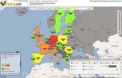
Up2Maps Europe - using Google Maps Flash API
Create Thematic Maps Fast with Up2Maps

Feature List
:
  • Maps can be exported to image (png) or embedded in blogs.
  • Data can be uploaded in excel files or typed directly in the application.
  • There are 2 levels of detail for each country.
  • Runs on Google Maps Flash API
  • Data includes territory names, zip/postal codes and international codification like FIPS and ISO.
Up2Maps Europe Editor
Map Editor - Build your own Thematic Map - Maps can be edited in many ways (colors, labels, legend etc)

Thanks to Moisés García
http://www.up2maps.net/

Ready Made Map EU Parliamentaries by Country
http://www.up2maps.net/maps/Gamusin23/Europe/ue_parliamentaries_by_country.html

Labels: , , , ,

18 May 2009

+30 Top Mapping Blogs (Mapperz=7th?)

+30 Top Mapping Blogs">+30 Top Mapping Blogs (Mapperz=7th?)

Another debatable chart to comment on:

(All these blogs should be number 1.)

According to
http://www.whatsyourplace.de

"Selling the world parcel-wise on Google Maps and being an officially featured project on Google code, we closely follow new developments in the rapidly expanding market of Maps Mashups and the use of digital maps in general. Fortunately, there is a number of great blogs focussing on mapping issues. We would like to share our list of what we consider the top blogs on maps. The top ranking is in accordance with the number of google reader feed subscribers (shown in brackets) at the point of writing this post."

  1. StrangeMaps (13.576) - taking a humerous approach to map depictions - recommended: WW II - if maps could fight
  2. Google LatLong (5.350) - official blog edited by the Google Maps and Google Earth team - recommended: Whale Spotting on Google Earth
  3. Google Earth Blog (3631) - unofficial blog on everything Google Earth - recommended : 3 D Buildings Layer Update
  4. Ogle Earth (3448) - on how Google Earth and related products affect geopolitics - recommended: Exploring Shanghai’s recent geographic history
  5. Google Maps Mania (2915) - mostly edited by GMaps developer Keir Clarke focussing on maps mashups - recommended: Big Art Project on Google Maps
  6. The Map Room (2678) - map blog targeting wider audience - recommended: Is GPS accuracy at risk?
  7. *Mapperz (2131 >2,145 now) - introduces new digital maps - recommended: Africa in Open Street Map, lots of miles * (Still debatable on this - Mapperz)
  8. Spatially Adjusted (2067) - fairly technical GIS blog by professional James Fee - recommended: Licensing issues on the Geoweb
  9. Google Geo Developers (1924) - official blog - recommended: Solution to too many markers problem
  10. AllPointsBlog (1.290) - professional and high-frequency source on location technology. Recommended: Did Navteq really launch a rival to Google Maps?

  11. Free Geography Tools (951) - recommended: Google Maps Route Creation with NetKvik
  12. Virtual Earth (837) - An Evangelist’s Blog - recommended: MSN City Guides Relaunches
  13. GISLounge (656) - GIS information portal - recommended: Finding Bin Laden
  14. Very Spatial (565) - recommended: Digital Cities Concept
  15. Thematic Mapping (379) - focus on maps and economic/political development issues - recommended: Using KML at Thematic Mapping
  16. Programmable Web (34) -tremendous resource and catalogue of API-based mashups - recommended: WhatsYourPlace
  17. The Map Scroll (284) - nontechnological maps-blog - recommended: Taliban Influence in Pakistan
  18. Digital Earth (262) - personal blog focussing mostly on new developments in Microsoft’s and Google’s digital maps products - recommended Google Earth Imagery Update May
  19. Paul Ramsey’s GeoTips (259) - Founding Member of the Open Source Geospatial Foundation - recommended: Web Mapping Architecture at OpenGEO
  20. GeoThought (211) - blog on location technology by industry expert Peter Betty - recommended: The GeoSpatial Technology Revolution (Keynote)
  21. The Electoral Map (207) - focussing on the “intersection between politics and geography” - recommended: 2008 in political geography
  22. ManDown (176) - technical perspective on GIS, ESRI in particular - recommended: arcGIS Mobile 9.4 - Whats next?
  23. CartoTalk (122) - more a forum than a blog, but great place to follow qualified geo-discussions
  24. WebMapper (211) - focussing on the latest trends in location based services - recommended: UK Crime Maps scrutinized
  25. Spatiallaw (102) - low-frequency blog focussing on intersection of legal issues and spatial technologies - recommended: Why Spatial Law?
  26. What is Special About Geospatial (67) - Geo-student blogging about the geoweb - recommended: introduction of Pixelcase, where Photography meets Geoinformation
  27. Google Maps Gone Wild (60) - Examples about things one can do with Google Maps - recommended: recursive queries in Google Maps
  28. Mibazaar (57) - introduces practical Google Maps Mashups - Swine Flu Tweets on Google Maps
  29. atlas(t) (52) - recommended: Shoe Map
  30. WhatsYourPlace (19) - Google Maps Mashup Selling the World - recommended: Obamas Road to Presidency
  31. Geo2Web (16) - GIS technology blog - recommended: Mapping the Death Penalty
  32. Maps and Earth (4) - recommended: Find Custom Maps
source:
http://www.whatsyourplace.de/blog/?p=607#more-607

Labels: , , , , ,