->

30 August 2011

FixMyTransport.com Beta

FixMyTransport.com Beta
FixMyTransport
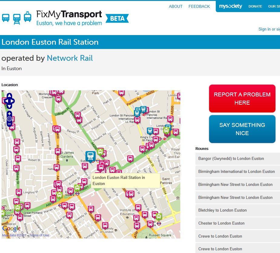
Clean Mapping Interface to report problems with your routes (bus, train,tram/metro ferry)

FixMyTransport options

FixMyTransport was built to help people get common public transport problems resolved. It is targeted specifically at smaller problems such as persistently broken ticket machines, buses that always leave early, or silly rules that appear to do nothing but create inconvenience for travellers.

What is it all about?
At a basic level, FixMyTransport makes it easy for people to send problem reports to the companies or authorities responsible for those problems.

However, we know that simply sending an email often won't be enough to get a problem resolved. That's why we've built a complete system to make it easy to gather support other people, whether fellow commuters, colleagues or friends. We believe that this is worth doing because a transport company that doesn't respond to one person may very well respond to ten.

We hope that FixMyTransport will also help people by becoming part of the wider internet community of transport activists and campaigners. In particular, we hope that that community comes to see FixMyTransport as a place where experts and old hands can transfer their skills to people who have little or no experience of lobbying for change.


As well as being aimed at helping people to solve transport problems, FixMyTransport represents an experiment to discover whether a sufficiently well designed internet service can help tip people over the edge from grumbling about a problem to taking action to resolve it. We welcome your thoughts on how to measure whether or not we're succeeding.

Created by http://www.mysociety.org/

FixMyTransport.com Beta (with map interface openlayers/googlemaps)
http://www.fixmytransport.com/

Labels: , ,

16 August 2010

Open Layers Heatmaps

Open Layers Heatmaps

"Making Open Street Maps even hotter!"

Open Layers OSM Heatmap
A Great Mashup to show 'HeatMaps' using Open Layers and Open Street Map Features (OSM).
Select a number of OSM Features and create dynamic heatmaps from them.
Note: this is the 'inverted' heatmap view.

Credit to Felipe Barriga (http://blog.felipebarriga.cl/)

If you want to create your own HeatMaps the source code is available via OLHeatmap.


What is OLHeatmap ?

OpenLayers Heatmap is a group of hacks ( talented programmers) to render heat maps over OpenLayers. At this moment is very ugly and dirty but I have some ideas in mind to make this a more presentable project....

Why that name ?

OLHeatmap stands for OpenLayers Heatmap

Video Demo


Video via http://opengeodata.org/osm-heatmaps-in-the-browser-w-openlayers

Heat Map
http://blog.felipebarriga.cl/olheatmap_demo/

Source:
http://blog.felipebarriga.cl/programacion/olheatmap-live-demo/

Labels: , , , ,

04 March 2010

SaferMK Community Safety Mapping by Zubed

SaferMK Community Safety Mapping by Zubed

A nice web GIS mapping solution....

SaferMK Community Safety Mapping by Zubed
Overlay of Crime data using Openlayers and using Ordnance Survey Mapping from the GetMapping Map Service

Clear thematic data is overlayed and fully interactive to query online but importantly easy to use by non-gis users (key fact!)

SaferMK Community Safety OS 25k Mapping by Zubed
1:25,000 Ordnance Survey (Explorer range) is used - making buildings and rights of way information viewable - you don't see this level of detail online often.

**Hopefully after the Ordnance Survey Consultation (Deadline 17th March 2010) this data and others is made available freely to use - Due April 2010.

The main features of the SaferMK Community Safety Mapping site are:
  • It provides details of All Crime and anti-social behaviour (ASB) incidents and trends over the previous 12 months.
  • It is a web-based mapping system allowing Neighbourhood and Area (estate, village or town) level analysis of crime and anti-social behaviour, using data obtained from Thames Valley Police, the Milton Keynes Council and Buckinghamshire Fire & Rescue Service.
  • It displays anti-social behaviour data that isn't published by any other source.
  • It displays information (data and graphs that show trend) in data balloons for each Neighbourhood or Area and gives comparison data against the whole of the borough.
  • It provides the ability for residents and users to download standardised data; and to produce a standardised anti-social behaviour report for a specific Neighbourhood, which includes graphs and tables.
Guidance:
http://www.milton-keynes.gov.uk/safermk/DisplayArticle.asp?ID=67095

View the Interactive Map - http://safermk.zubed.com/

Credit to Zubed for the creation and implementation of this easy to use web mapping solution.

Labels: , , , , , , ,

02 July 2009

OpenFlights - Route Mapping The World

OpenFlights - Route Mapping The World

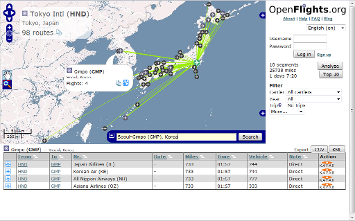
OpenFlights is a tool that lets you map your flights around the world, search and filter them in all sorts of interesting ways, calculate statistics automatically, and share your flights and trips with friends and the entire world (if you wish). It's also the name of the open-source project to build the tool.

OpenFlights Routes Across the World

Search by Click the Icons on the Map or Airport Code, Airport Name or IATA Name- a very handy Aiport Map. Mapping base by OpenLayers

Note: Now, you can click on any airport and see every single scheduled flight:

Testing Stages:

OpenFlights has been going through Alpha, Beta and Gamma test phases, OpenFlights is now in its Delta phase: all core functionality is implemented, but development on new features continues. If you'd like to be informed about major updates to the site visit their blog


OpenFlights Routes Official Example

For easy access to this, we’ve added a Quick search widget, shown expanded above but normally hiding in the bottom-right corner under the icon. Here’s how to use it, in two easy steps:

  1. Enter the airport name, city or IATA code in the box. OpenFlights will automatically suggest matches as you type, and if the airport is already shown on the map, OpenFlights will pop it up.
  2. Once you’ve entered a valid name, the Search button becomes active. If you click on this, OpenFlights will load a route map showing all flights from that airport.

But there’s more! In the popup for every airport, there’s now a Routes button, which you can also use to see the map. If you click on the List button for the mapped airport (via popup or the top left corner), you’ll get a list of all flights operating from there; if you click on that button for another airport, you’ll get a list of all airlines connecting the two, even including codeshares.

Source and Image:

http://openflights.org/blog/2009/06/26/route-mapping-the-world/

Visit the OpenFlights Route Map


Labels: , , , , ,

18 June 2009

Sustrans Map - Measure Your Route

Sustrans Map - Measure Your Route

"Sustrans is the UK's leading sustainable transport charity. Our vision is a world in which people choose to travel in ways that benefit their health and the environment. Every day we are working on practical, innovative ways of dealing with the transport challenges that affect us all."

Sustrans Map

The Sustrans Map uses Openlayers and data from Ordnance Survey - a Dotted Eyes creation.

Sustrans aims are:

  • reduce the environmental and resource impacts of transport
  • enable people to choose active travel more often
  • provide car-free access to essential local services
  • create streets and public spaces into places for people to enjoy.
The Unique 'Value Added Tool' for this map is the Interactive Route Creation which dynamically shows the user the distance and time it takes whilst digitising your own route:

Sustrans Map Measure Route
Custom route creation - displays average time and distance as you build your route.

The refresh display speed of the background maps are not the fastest but the usefulness of the tool overrides this bottleneck.

Link to Sustrans Birmingham Map (as above though zoom in)
http://www.sustrans.org.uk/map?searchtype=search&searchkey=Birmingham

Labels: , , , , ,

29 April 2009

A to Z London 1930's Map Online [Slippy Map]

A to Z London 1930's Map Online [Slippy Map]

A to Z London 1930s
A to Z have put the original 'A to Z' 1930's London Map online using Openlayers and Mapserver

"Discover the streets of a bygone age with a nostalgic look back in time at this early edition of the famous London A-Z."

View an extract taken from the 1930's London map


"The original printing of this paperback street atlas before the Second World War was in black only; however, this facsimile reproduction has been printed in colours which simulate the current condition after its ageing over many years."

"Geographers' Map Company was founded in 1936 by Phyllis Pearsall MBE (1906-1996) who, encouraged by her father Alexander Gross, took on the ambitious task of publishing up-to-date street mapping of London. This Historical Edition is a facsimile reproduction of one of her first publications featuring the now renowned A to Z logo on the front cover."

London Street Atlas - Historical Edition is available in paper form
http://www.a-zmaps.co.uk/?nid=60&iid=3554

Labels: , , , , , ,