->

06 September 2011

TFL - Next Bus - Mobile

TfL - Next Bus - Mobile

what a great idea - a mobile site where you can put your street,bus stop id, postcode and find out when the next bus is coming!

Well it is here - Transport for London (TfL) have created this site.

Live Bus Departures


You can filter the routes or store as 'My Stops' for future reference.

Routes for Regent Street 


source:

Labels: , , , , ,

22 August 2011

Bing Maps Streetside - London UK

Bing Maps Streetside - London UK

Bing Maps Streetside - London UK
Streetside is now available for some parts of London, England

Bing Maps Streetside - Westminster Bridge London UK
Westminister Bridge, London Bus and London Eye Iconic Landmarks, but do not expect 'Google Streetview' type functionality this is more a slide-show of images.


More information on Streetside
http://www.microsoft.com/maps/en-GB/streetside.aspx

View Streetside - London UK (click the icon next to Traffic)
http://www.bing.com/maps/?v=2&cp=51.50085314131346~-0.12088798043215165&lvl=14&dir=0&sty=r&trfc=1&form=LMLTCC

cross-posted from BingMapsWatch

Labels: , , , ,

23 June 2011

London Geographic Tube Map

London Geographic Tube Map

London Geographic Tube Map


Mark Noad created this geographical London Tube Map. Showing all stations on the underground network related in real-world locations. Note the River Thames is a realistic shape.

The map is an unofficial response to a recent backlash against the original version, created designed by Harry Beck. This is often described as a ‘classic’ schematic map , showing routes and stations logically rather than geographically.

London Original Tube Map

Harry Beck's original tube map - http://en.wikipedia.org/wiki/Tube_map

View the geographical version:http://www.london-tubemap.com/

Source:

http://londonist.com/2011/06/alternative-tube-maps-a-new-geographic-map.php

Labels: , , , ,

16 June 2010

Transport for London - Data Released June 2010

Transport for London Data Released June 2010

Transport for London Data Release
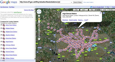
Tube Stations Data (but not up-to-date) in KML format

Data is Available from Here [Feb 2010]
Metadata is Here

Mapped


What is Free?

The London Datastore currently hosts the following travel-related data sets: Via the TfL developer page:

Station Locations

TfL Pier Locations

Live Traffic Cameras

Oyster Ticket Stop Locations

Static files on GLA servers

Cycle Hire Locations

London Underground Signals Passed at Danger

TfL Investment Programme

TfL Business Plan

Riverboat Timetables

The LDS says it is "currently working" on also releasing more datasets by 30 June 2010, including

- Bus Stops

- Bus Routes

- RODS Data (Rolling Origin and Destination Survey Data).

[Note: LIVE FEEDS ARE NOT AVAILABLE signing up required.]

Links to Examples:

http://www.tfl.gov.uk/tfl/businessandpartners/syndication/example-feeds.aspx

Thanks to the Guardian and it's campaign

Labels: , , , , , ,

23 February 2010

TfL Bus Route Maps (now using Google Maps)

TfL Bus Route Maps (now using Google Maps)

Transport for London (TfL) have launched Bus Maps using Google Maps.
*almost a contender for best UK Map Mashup Ever.
TfL Bus Routes Google Map Mashup
Example route 38 Daytime with all bus stops listed
TfL Bus Routes Google Map Mashup Night Time
Night-time Route 38 - with all stops.

Optional Night or Daytime Routes

Clear Directions and all stops included

Nice 'search for routes near here' feature
TfL Bus Routes Google Map Mashup Routes Near Here
Search other nearby routes or plan your journey - or check for planned disruption.


Bus Stops Times and Frequency
Timetables and Bus frequency is available for all bus stops making it much easier to find your best routes.

If this were in 'real-time' - similar to Real-Time Buses on Google Maps 'University of Michigan Magic Bus' then this would be one of the best Google Map UK Mashups ever >> Met Office Invent still leads that in @mapperz opinion. Still a very good update to what was on offer before.

View the Map with Bus Routes
http://www.tfl.gov.uk/tfl/gettingaround/maps/buses/default.aspx

old maps [pdf's still exist]
http://www.tfl.gov.uk/tfl/gettingaround/maps/buses/busdiagrams.asp


found blogged by Mapperz

Labels: , , , , , , , ,

London Interactive Movie Map

London Interactive Movie Map

"Film London has created this new online resource so that you can discover or revisit sites where some of the most memorable scenes in the history of cinema took place. Search by type of film - from romantic flicks to action-packed movies or period dramas - or explore by viewing different parts of London."

Love Films and Love London? This map brings the two together.

Film London Movie Map
Click on the left-hand sidebar to choose your genre and see the suprising amount of new and old films that have been partially or fully made in London.

Choose from:

"London has inspired many truly memorable movies and for more than a century has welcomed world-class film-makers to tell their stories here. One of the most recognisable and widely used film locations in the world, the city itself has been the star of many great films from romantic comedies to action adventures, sci-fi thrillers and period dramas. The sheer range of London films demonstrates how cinema has become part of the fabric of the city with many places now instantly associated with moments from the silver screen."

Showcasing one of the most cinematic cities in the world, the Movie Map is the first project from the newly launched Love from London brand, Film London’s banner for its film-based tourism initiatives.

London residents, the city’s visitors, film buffs and anyone interested in the capital’s cultural heritage are invited to discover or revisit sites where some of the most memorable scenes in the history of cinema actually took place. Londoners and tourists alike may choose to have their own Brief Encounters at Regent’s Park boating lake, as seen in David Lean’s 1945 tale of forbidden love or watch out for signs of Harry Potter and the Half-Blood Prince’s ruinous Death Eaters before crossing the Millennium Bridge or even try to retrace Jason Bourne’s pursuit at Waterloo Station in The Bourne Ultimatum.

This map will be kept up-to-date.
The map is a live tool, it has been launched with just a small selection of locations and films but will be updated with more information and further layers. Help us build this resource and email us with your comments and suggestions* at lovefromlondon@filmlondon.org.uk
*film search option please

View the Interactive Google Map of Films in London
http://www.filmlondon.org.uk/content.asp?CategoryID=1234

source:
http://www.filmlondon.org.uk/news.asp
Official Press Release - http://www.filmlondon.org.uk/press_details.asp?NewsID=1831

Labels: , , , , , ,

26 December 2009

The London Of Sherlock Holmes...Mapped

The London Of Sherlock Holmes...Mapped
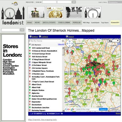
Sherlock Holmes Film (2009)
The New movie and the New Map of Locations

Sherlock Holmes Map London Locations
Find the locations of Sherlock Holmes and even some answers to clues on this Map of Sherlock Holmes in London.


The whole world is about to go Sherlock Holmes bonkers, due to the Warner Brothers movie starring Robert Downey Junior and Jude Law and Directed by Guy Ritchie of Lock Stock and 2 Smoking Barrels and Snatch fame.

"With each new telling, the character receives a certain amount of reinvention. One thing is constant, though. London. You can't have Holmes without the city he was so intimately associated with. But which parts of town did he know best? Our well of nerdiness will never run dry, so we re-read all the original Holmes tales and plotted every London location on the map above.

Some interesting patterns emerge. Naturally, there's plenty of action around the Baker Street area, but Holmes never once set foot in nearby Soho. Zooming out, there's a surprising cluster of incidents around Crystal Palace. The reason is elementary when you know that Sir Arthur Conan-Doyle lived for a time in South Norwood. We haven't plotted the numerous out-of-town locations mentioned in the books, but you can get a sense of Holmes' peregrinations by noting which rail stations he used most. Southern stations Charing Cross and Waterloo are visited a combined total of 16 times, while King's Cross and Euston are only blessed with the detective's patronage on four occasions."

Key: Green = precise location; red = imprecise location; purple = real-world Holmes-related sites; blue line = route taken by Holmes. Page numbers refer to those in the Folio Society's 1994 collection

source: The Londonist

Created by the Excellent Tools at Map Channels

View the Map
http://londonist.com/2009/11/the_london_of_sherlock_holmesmapped.php

Official Film (2009)
Official Website for the New Movie
http://sherlock-holmes-movie.warnerbros.com/


Labels: , , , , ,

22 October 2009

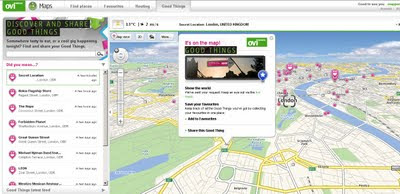
Nokia - Ovi Good Things

Nokia - Ovi Good Things

Nokia - Ovi Good Things
http://maps.ovi.com/goodthings/f84c5631-eec4-4ee6-8c04-872622dc1cb0/Secret-Location

(that's the location but you need a special token)

Labels: , , , , ,

24 August 2009

The Hot Tube [underground] Map

The Hot Tube [underground] Map

London Underground Tube Hotspots Temperature Map

Transport for London have release a snapshot of the temperatures that were recorded July 28th - July 29th 2009.
Central Line was the hottest with temperatures up to 32C.

Temperatures seem to be at the highest during 4pm and 7pm


"TfL have revealed the hottest spots on the London Underground to identify the areas which need the most cooling. The heat map compiled on July 28 - one of the hottest days of the year, showed the Central Line was the warmest. Luckily it was already coloured red. That part of the network was above 30C (86F)."

(In previous tests , temperatures in some parts during the summer have exceeded 35C, which would make the network officially unfit for transporting cattle.)


Now if only there was a live version of the map, in real-time.

The Map 'undegroundhotspots' (in PDF format)
http://extras.timesonline.co.uk/pdfs/undergroundhotspots.pdf

source:
http://london-underground.blogspot.com/2009/08/tube-map-shows-hottest-spots.html

Labels: , , , , ,

20 August 2009

192.com Aerial Imagery Updated

192.com Aerial Imagery Updated

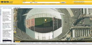
192.com have updated the to most up-to-date online aerial photography for London.
High Resolution aerial photography from Getmapping.com
The new imagery has been captured using the latest digital camera technology with each image pixel equivalent to 12.5cm from the ground. The result are high quailty true-colour photographs - right down to road markings and visable street furniture.

This data is more up to date than google 'satellite' mode and microsoft bing aerial (multimap) mapping sources.

192.com Aerial Mapping Updated

New orthorectified aerial images on 192.com include Wembley Stadium including the Wembley Arch and Wimbledon’s new multi-million centre court roof. Also visible on the new photography is the beginning of the preparations for The Ashes Test Matches at Lords and the Oval Cricket grounds.

"This new photography shows a step forward for aerial imagery used on the net and we believe it will help our users to get richer search results and a more enjoyable experience. The images are truly amazing and even let people check out the most recent aerial shots of their home."
Dominic Blackburn - Product Director

Check the new updated aerial photographs
http://www.192.com/places/


A couple links to some well know landmarks:

Buckingham Palace
http://www.192.com/places/search/?Type=All&place=BUCKINGHAM%20PALACE&gre=529168&grn=179747
(includes Super Zoom Mode)

Wembley Stadium
http://www.192.com/places/search/?location=wembley%20stadium&distance=1838&page=1&searchType=All&place=WEMBLEY%20STADIUM&gre=519384&grn=185519

source:http://www.journalism.co.uk/66/articles/535540.php
& email - thanks to Neil Watts - neil.watts@192.com

Labels: , , , , , ,

25 June 2009

Google City Tours (Labs)

Google City Tours (Labs)

Google City Tours Google Labs - London


Google Labs " Google City Tours" which uses Google Maps. The idea is that anyone can locate points of interest and plan up-to three day trips in major cities.

City Tours has a number of tours for pre-set for San Francisco, New York, London and Dublin. Major landmarks, museums and art galleries are available in each of the cities.


Landmarks can be edited on your own tour using the google map. Info windows display this information for the markers includes user rating and the opening hours. The Sidebar shows the order of the walk and the time it should take to walk from one location to the next.

City Tours Example - London Day 2
Mapperz Suggestion: The walking directions should follow the walkable path for the streets and not as the crow files in this case. Hopefully this gets an update.

Try it here
http://citytours.googlelabs.com
[Google account require to edit and save/rate tours]

Related post:
http://googlemapsmania.blogspot.com/

Labels: , , , , , , ,

29 April 2009

A to Z London 1930's Map Online [Slippy Map]

A to Z London 1930's Map Online [Slippy Map]

A to Z London 1930s
A to Z have put the original 'A to Z' 1930's London Map online using Openlayers and Mapserver

"Discover the streets of a bygone age with a nostalgic look back in time at this early edition of the famous London A-Z."

View an extract taken from the 1930's London map


"The original printing of this paperback street atlas before the Second World War was in black only; however, this facsimile reproduction has been printed in colours which simulate the current condition after its ageing over many years."

"Geographers' Map Company was founded in 1936 by Phyllis Pearsall MBE (1906-1996) who, encouraged by her father Alexander Gross, took on the ambitious task of publishing up-to-date street mapping of London. This Historical Edition is a facsimile reproduction of one of her first publications featuring the now renowned A to Z logo on the front cover."

London Street Atlas - Historical Edition is available in paper form
http://www.a-zmaps.co.uk/?nid=60&iid=3554

Labels: , , , , , ,

24 April 2009

London Marathon Maps 2009

London Marathon Map 2009

Racing starts 9.00am BST on Sunday 26th April 2009

9am Elite Women's Race Starts
9.25am Wheelchairs Race Starts
9.45am Elite Men's Race Starts
9.45am Mass Starts

BBC Sport London Marathon Map 2009 - Virtual Earth
BBC using Virtual Earth - No Route. and have some issues with the users in the US not centering on London. (Overlay a KML file would provide a route)
http://news.bbc.co.uk/sport1/hi/athletics/8011891.stm

How 'live' is this map? [Race starts 9.00am BST on Sunday 26th April 2009]

New content is added to the map as soon as it becomes available - in many cases there is a short delay involved, as video, audio and images must be received and edited before being published.

But it looks like nothing had changed.

You need to refresh the page to see updates. Some points on the map, for example image galleries, update with fresh content as the marathon progresses. In other cases, older content is removed from the map and replaced by newer content from a similar area.

It would have been useful to see the full marathon route on this map.

We agree. This was not possible this year, but we expect to offer this in future.

Overlay a KML file would work.

For a Route Map see the Guardian
http://www.guardian.co.uk/lifeandstyle/interactive/2009/apr/22/london-marathon-route-map and click 'Runner'
Guardian London Marathon Route Map 2009
Image from The Guardian

Route Planner
http://www.realbuzz.com/flmroutes/map.html
links from the Official Site - http://www.london-marathon.co.uk/site/
(not the best - needs updating from last year)


View Larger Map
This route might incorrect as it is from an old source (2005) but took 0.22 seconds to find

Labels: , , , , , ,

17 February 2009

London 2012 Olympic Progress Map

London 2012 Olympic Progress Map

London Olympic 2012 Puilding Progress Map
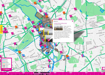
A little busy in places but gives a clear indication on the progress of the building of the Olympic Venues

"There is such an opportunity here. It would be superb if you could include photos uploaded to sites such as flickr, the image-sharing website."
why not?

The Interactive Map
http://www.london2012.com/in-your-area/map/index.php
*Tip as this is based in Flash - right click and select 'Go Full Screen'

Firebug tells the developer there is an underlying API for the Map
http://data.map.london2012.com/


Timeline at the bottom
"timeline so visitors can see milestones in the project, and live webcams of construction sites"

Source: This is London

Labels: , , , , ,

15 October 2008

StreetView France Expands

StreetView France Expands

StreetView Paris
The StreetView areas expand in Paris

Other Towns and Cities
What about London UK?
Well if you cannot wait for Google to launch it - there currently is an alternative
Seety has limited coverage and quality is not as good in places they openly admit.

Approx coverage is Hammersmith [West], Blackwall Tunnel [East], Swiss Cottage [North] and Vauxhall [South]
Seety London StreetView
StreetView for London, UK try it here
http://www.seety.co.uk/?lat=51.50971&lon=-0.13503&u=0.995&v=0.517

Source: Google Maps Mania

Labels: , , , , , ,

17 September 2008

Google Developer Day 2008 - Wembley Stadium London

Review of the Day at Wembley Stadium 17/09/2008
Wembley Turf
The new turf getting laid down for the next event England v Kazakhstan
(thanks the friendly security guard for letting me go turf side to take this pic.)

Google Developer Day, London,UK
Nothing amazingly new, geolocation for mobiles, GeoIP location, some new phone that shows maps fairly quickly. (though not it's real location)

Google Developer Day 2008,Wembley Stadium, London, UK
Meeting some of the real developers people for Google Maps API but not all. Some wanting more details of what is coming - like the reverse geocoder and new geocoder response (creates a bounding box set of coordinates so zoom levels can be applied).
But Google rarely give away what is likely to be coming out.

Seemed a little less busy than last years event maybe due to having more space.

Some items like 'clouds' and 'dojo' completely over my head for some of it.
Like the Google Apps potential for saleability - 4 users or 400,000 users hosted and load balancing handled by Google.


(jump to 2.25 minutes in the video to view the maps)

Good Food, Good Location, Good Company made a nice day out.

Thanks to all that made it happen.

Update: 12/09/2008
http://sites.google.com/site/developerdaylondon/gddhome

Google Developer Day 2008(London,UK)


View Larger Map

Google have announced the full line up for the day

Here are the 'Mapping' related sessions

Mashing up Google Data APIs
Ryan Boyd
This session will provide a quick overview of Google Data APIs and demonstrate some ways to use them in mashups with other APIs like Maps, App Engine and more. Expect to see code in a variety of languages.
Prerequisites: Developers attending this session should be comfortable with at least one of PHP, Python, JavaScript or Java. Experience working with REST-based APIs a plus.

A Deeper Look at Google App Engine
Mano Marks
Google App Engine allows you to build and run applications on the same highly scalable web infrastructure that Google uses to run it own applications. This allows you to build an application once, and then never have to worry about how many people are using it, how many machines you're using, or how you're going to handle all the traffic. This talk will introduce you to the basic features of Google App Engine, and walk you through building a quick, interactive application.

Some of the topics we will cover are:
App Engine's Datastore
Authentication using Google accounts
The web framework
Our image manipulation API
Using Memcache
App Engine best practices
This session is intended for intermediate developers who are new to Google App Engine.
Prerequisites: If you want to follow along with setting up an application, then you should have a laptop with Python 2.5 and the App Engine Development Server installed and an App Engine account. Python knowledge is helpful but not required.

What's New in Geo
Russell Middleton
This session will cover recent developments in Google Maps and Google Earth, including the Earth browser plugin and new ways to share and leverage geographic data.
Prerequisites: Basic knowledge of XHTML, CSS, XML and Javascript

Gears for mobile and the new Geolocation API
Charles Wiles
This session will provide an overview of Gears and it's usefulness in mobile browsers and then focus on how you can easily location-enable web apps with a few simple javascript calls.
Prerequisites: You should have reviewed the Gears APIs on code.google.com/apis/gears and in particular, have familiarised yourself with the Geolocation API.

Note:It is recommended you have a laptop with the 'Prerequisites' installed.

Source:
http://code.google.com/intl/en_uk/events/developerday/2008/speakers.html
http://code.google.com/intl/en_uk/events/developerday/2008/sessions.html

Labels: , , , , , ,

21 August 2008

Transport for London - Cycle Maps - New!

Transport for London - Cycle Maps - New!
Transport for London Cycle Map
Transport for London first by using Google Maps for showing Cycle Parking and best routes.

Routes preferences:
  • Cycling on quieter roads
  • Cycling near to busy roads
  • Cycling through parks and canal tow paths
  • Cycling that may be on busier roads
  • Cycling is not permitted
Google Map viewable here
http://www.tfl.gov.uk/tfl/roadusers/cycling/maps/maps-and-guides.aspx


Transport for London Cycle Map - Many Options
Though the routing 'wizard' has different mapping (bespoke TfL created?).

There is a really good amount of options, 'I don't want to cycle more than xx minutes' very handy.

See the Cycle Planner and Map


The video shows the 'wizard' in action - suggestion speed and time might be a useful addition.

Labels: , , , , ,

15 August 2008

London Metropolitan Police Crime Mapping (TEST SITE)

London Metropolitan Police Crime Mapping (TEST SITE)
Metropolitan Police Crime Mapping TEST SITE
Polygons are generalised but the thematic map shows the crime rates across Greater London.

Areas of London are colour coded to show crime levels in user selected areas relative to other areas of London. Specifically, areas are colour coded according to how their crime rates compare to the average for London. This is done using standard deviations - a statistical measure used here to calculate how close to the London average an area´s crime rate is. The following ranges are used to describe this within the maps:
  • Burglary, robbery and vehicle crime
    (June 2008)
  • High
  • Above Average
  • Average
  • Below Average
  • Low
"The purpose of this site is to help show where crime is occurring at a local neighbourhood level.

It has been developed by the MPS in conjunction with the Metropolitan Police Authority and the Mayor of London.

This is a live test site (known technically within the industry as a 'beta'). It is intended to test the functionality of crime mapping, with a view to adding further features in the near future, based on your feedback.

Please note, that whilst every effort is made to record the details of crime and its location as accurately as possible, there are occasions when victims are unable to provide the actual location of a crime. In these instances, the site will not be able to display all the crime reported to the police."

http://maps.met.police.uk/


Labels: , , , , , ,

06 April 2008

Olympic Torch Relay Map

update 07/04/2008 : A more interactive map (actually a gadget)
Interactive Torch Map (Gadget)
It is suppose to reach Paris today, more high security?
source and link to the map
http://www.webware.com/8301-1_109-9912381-2.html

The gadget is available
http://maps.google.com/help/maps/torchrelay/
There is also an update and you can now view in Google Earth.


Olympic Torch Relay Map


Olympic Torch Map


Currently its running around London (31 miles) with some fire extinguisher protesters in tow.

http://torchrelay.beijing2008.cn/en/journey/journeymap/


Olympic Torch Route Map London

Route Map BBC Source


Source:

http://www.olympic.org/uk/news/olympic_news/full_story_uk.asp?id=2521

Labels: , , , ,

05 February 2008

London Low Emission Zone Maps

London Low Emission Zone Maps
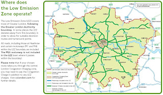
The Low Emission Zone (LEZ) commenced on 4 February 2008.

Updated post (4th January 2012)
http://mapperz.blogspot.com/2012/01/low-emission-zone-map-london-uk.html

London Low Emission Zone Maps
bigger than you thought?
Image source page 10
http://www.tfl.gov.uk/

"The Low Emission Zone (LEZ) affects older, diesel-engined lorries, buses, coaches, large vans (exceeding 1.205 tonnes unladen weight) and minibuses (over eight seats and below 5 tonnes)."

  • The LEZ does not apply to cars and motorcycles.
  • The LEZ applies to all roads and some motorways across most of Greater London NOT just the central London Congestion Charging zone
  • The LEZ operates 24 hours a day, every day of the year which is different to the central London Congestion Charging hours.
  • Your vehicle must meet Euro III standards for particulate matter to be driven within the zone or you will need to pay a £200 daily charge
Over 257 Maps for the fringe boundaries.
** All maps in PDF format some are large file sizes (14mb+)

Labels: , , ,