->

25 February 2010

Google Fusion Maps - February 2010 Update

Google Fusion [Tables] Maps - February 2010 Update - More Powerful

An Interesting update here in a previous blog post
Note: Suggestions, would be nice to be able to overlay the thematic map [based in flash] over the Google Map (or creating gpolygons). Sharing with the option of embedding and link to would be convenient.

Well seems like this service has improved:
How?
  • Some new features that will let you upload and map large amounts of geographic data.
  • You can also now hide and show different data depending on your own criteria.
  • Create Custom HeatMaps with your own data.
  • You Do NOT need to be a Developer.
  • Embed Your Map to your website or blog.
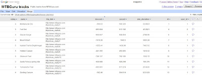
Google LatLong Blog has a great example of the new power (without being a developer)
Google Fusion Tables Routes Datasource
Go from the this table of Bike Tracks.. http://tables.googlelabs.com/DataSource?dsrcid=11310

to a nice bike tracks map with routes and altitude on a map with little or no programming.
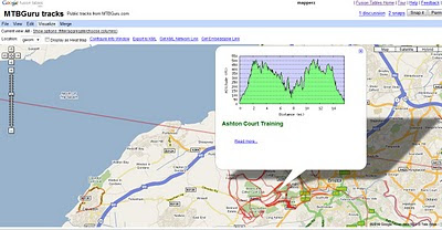
Google Fusion Tables Routes Mapped

Points are displayed at small scales but zoom in and routes of bike tracks are displayed very fast on the map Note: Goto 'Visualize >Map
http://tables.googlelabs.com/DataSource?dsrcid=132848

http://www.mtbguru.com/ is responsible for this first example using this method, mapperz highly recommends readers to look at the blog post: http://blog.mtbguru.com/2010/02/24/mtbguru-tracks-as-seen-through-google-fusion-tables/
which goes through the motions clearly on how to do this. Then you can try it with your own datasets.

Create Heatmaps
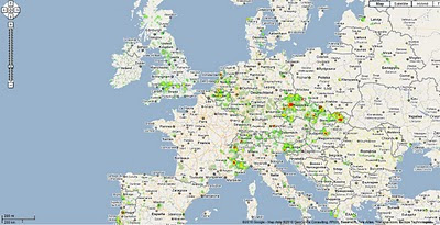
Google Fusion Tables Routes Heatmap
You can even create Heat Maps simply with your own data.

A great way to get started on mapping your own data.

Embed the Map:


(for the coders)

Using iframe
iframe width="500px" height="300px" scrolling="no" src="http://tables.googlelabs.com/embedviz
viz=MAP&q=select%20col0,col1,col2,col3,col4,
col5,col6,col7,col8,col9,col10,col11
%20from%20132848%20where%20col11%20%3E%20'70'&h
=false&lat=49.85392252759648
&lng=14.85626220703125&z=9&l=col10"/iframe

Under the hood:
http://maps.google.com/maps?gwt=1&file=api
&client=google-fusiontables&sensor=false&v=2.x">

var map = new GMap2(document.getElementById("map_canvas"));
map.setCenter(new google.maps.LatLng(49.98,14.88),9);
var l = new GLayer("span style="font-weight: bold;">ft:132848");
<< style="font-weight: bold;">select+col10+from++132848/span"); 
Select column 10 from fusion table ID

map.addOverlay(l);
map.setUIToDefault();
map.addControl(new GMapTypeControl());
map.addControl(new GLargeMapControl());
map.addMapType(G_PHYSICAL_MAP);

Source and More details on http://google-latlong.blogspot.com/2010/02/mapping-your-data-with-google-fusion.html
credit to http://www.mtbguru.com/

Labels: , , , , , ,

23 February 2010

TfL Bus Route Maps (now using Google Maps)

TfL Bus Route Maps (now using Google Maps)

Transport for London (TfL) have launched Bus Maps using Google Maps.
*almost a contender for best UK Map Mashup Ever.
TfL Bus Routes Google Map Mashup
Example route 38 Daytime with all bus stops listed
TfL Bus Routes Google Map Mashup Night Time
Night-time Route 38 - with all stops.

Optional Night or Daytime Routes

Clear Directions and all stops included

Nice 'search for routes near here' feature
TfL Bus Routes Google Map Mashup Routes Near Here
Search other nearby routes or plan your journey - or check for planned disruption.


Bus Stops Times and Frequency
Timetables and Bus frequency is available for all bus stops making it much easier to find your best routes.

If this were in 'real-time' - similar to Real-Time Buses on Google Maps 'University of Michigan Magic Bus' then this would be one of the best Google Map UK Mashups ever >> Met Office Invent still leads that in @mapperz opinion. Still a very good update to what was on offer before.

View the Map with Bus Routes
http://www.tfl.gov.uk/tfl/gettingaround/maps/buses/default.aspx

old maps [pdf's still exist]
http://www.tfl.gov.uk/tfl/gettingaround/maps/buses/busdiagrams.asp


found blogged by Mapperz

Labels: , , , , , , , ,

London Interactive Movie Map

London Interactive Movie Map

"Film London has created this new online resource so that you can discover or revisit sites where some of the most memorable scenes in the history of cinema took place. Search by type of film - from romantic flicks to action-packed movies or period dramas - or explore by viewing different parts of London."

Love Films and Love London? This map brings the two together.

Film London Movie Map
Click on the left-hand sidebar to choose your genre and see the suprising amount of new and old films that have been partially or fully made in London.

Choose from:

"London has inspired many truly memorable movies and for more than a century has welcomed world-class film-makers to tell their stories here. One of the most recognisable and widely used film locations in the world, the city itself has been the star of many great films from romantic comedies to action adventures, sci-fi thrillers and period dramas. The sheer range of London films demonstrates how cinema has become part of the fabric of the city with many places now instantly associated with moments from the silver screen."

Showcasing one of the most cinematic cities in the world, the Movie Map is the first project from the newly launched Love from London brand, Film London’s banner for its film-based tourism initiatives.

London residents, the city’s visitors, film buffs and anyone interested in the capital’s cultural heritage are invited to discover or revisit sites where some of the most memorable scenes in the history of cinema actually took place. Londoners and tourists alike may choose to have their own Brief Encounters at Regent’s Park boating lake, as seen in David Lean’s 1945 tale of forbidden love or watch out for signs of Harry Potter and the Half-Blood Prince’s ruinous Death Eaters before crossing the Millennium Bridge or even try to retrace Jason Bourne’s pursuit at Waterloo Station in The Bourne Ultimatum.

This map will be kept up-to-date.
The map is a live tool, it has been launched with just a small selection of locations and films but will be updated with more information and further layers. Help us build this resource and email us with your comments and suggestions* at lovefromlondon@filmlondon.org.uk
*film search option please

View the Interactive Google Map of Films in London
http://www.filmlondon.org.uk/content.asp?CategoryID=1234

source:
http://www.filmlondon.org.uk/news.asp
Official Press Release - http://www.filmlondon.org.uk/press_details.asp?NewsID=1831

Labels: , , , , , ,

22 February 2010

RAC Map Widget

RAC Map Widget

"This handy widget to put on your site. This widget will not only provide a map of your address, but also allow visitors to your site to fully plan their route to you, using our Routeplanner technology."


Web Route Travel Planner is available via http://www.rac.co.uk/route-planner/

The widget can be set to any width you want, meaning it will fit perfectly on your site.

Uses Bing Maps

http://www.rac.co.uk/widgets/routeplanner/

Can see the AA (Automobile Association) creating one soon. (currently only via http://widgets.yahoo.com/widget/aa-route-planner via http://www.theaa.com/travel/travel-widgets.html)

Labels: , , , , , ,

18 February 2010

New Google Maps domains in 29 African Countries

New Google Maps domains in 29 African CountriesGoogle Maps Ghana
Example Ghana Google Maps - http://maps.google.com.gh/ in Beta

Google Maps users can now find local businesses, towns, highways, or roads. This could be a burger place in Lagos, a garage in Kampala, a hairdresser in Accra or an airport shuttle in Dakar. Any business anywhere can add their own business listing for free via the Google Maps Local Business Centre.

South Africa gets its own mobile site - http://www.google.com/intl/en_za/mobile/

The active list so far: 18 of 29...

http://maps.google.co.ke/ Kenya
http://maps.google.com.na/ Nambia
http://maps.google.com.ng/ Nigeria
http://maps.google.com.et/ Ethiopia
http://maps.google.com.sl/ Sierra Leone
http://maps.google.cg/ Congo, Republic of,
http://maps.google.ci/Côte d'Ivoire
http://maps.google.dj/ Djibouti
http://maps.google.ga/ Gabon
http://maps.google.gm/ The Gambia
http://maps.google.com.gh/ Ghana
http://maps.google.mw/ Malawi
http://maps.google.sn/ Senegal
http://maps.google.co.mz/ Mozambique
http://maps.google.co.bw/ Botswana
http://maps.google.co.tz/ Tanzania
http://maps.google.co.zm/ Zambia
http://maps.google.co.zw/ Zimbabwe

Source:
http://google-africa.blogspot.com/2010/02/new-maps-domains-in-29-african.html

Google Maps API Geocoder now uses the Localised versions
Example Ghana (Major Roads, MapMaker Additions)
Please use the Google Spreadsheet for more countries covered.
http://gmaps-samples.googlecode.com/svn/trunk/mapcoverage_filtered.html

@Mapperz

Labels: , , , , , ,

17 February 2010

360 Vancouver Aerial Images and Covers Olympic Village

360 Vancouver Aerial Images and Covers Olympic Village

Vancouver 360 Vanier Park
Clean, Smooth and High Resolution 360 Aerial Images of Vancouver

Vanier Park
http://www.aerialphotoimage.com/panoramas/GreaterVancouver/VanierPark.html

Vancouver Water Front
http://www.aerialphotoimage.com/panoramas/GreaterVancouver/VancouverWaterFrontParkAerial.html

And inside BC Place
http://www.aerialphotoimage.com/panoramas/GreaterVancouver/OlympicsOpeningCeremony1.html

Stanley Park
http://www.aerialphotoimage.com/panoramas/GreaterVancouver/VancouverWestEndAerial.html

Labels: , , , , , ,

15 February 2010

BBC ThrillSeeker Map

BBC ThrillSeeker Map

ThrillSeeker is a BBC initiative to inspire everyone to get a taste of adventure. The BBC is working with hundreds of organisations who will be offering taster activities across the UK.

BBC Thrillseeker Map

Active Adventures from Easy, Adventurous, Adrenaline Rush to Extreme are easy to find across the UK using the Interactive Map.

The ThrillSeeker campaign is working with a wide range of partners across the UK to deliver a fantastic range of taster activities to get you started on the road to adventure. The activities, all free or at a reduced rate, range from adventure storytelling and walking to archery and rock climbing - so there's something for everyone, no matter what your age or ability.

28 Page Guide [PDF] http://downloads.bbc.co.uk/thrillseeker/pocket_guide_english.pdf

BBC Classifications:

Easy
Swimming
Walking

Adventurous
Bodyboarding
Falconry
Running
Skateboarding

Adrenaline Rush
Coasteering
Fencing
Karting
Powerkiting
Surfing
Water skiing

Extreme
Gliding
Parachuting
Paragliding and hang gliding

BBC ThrillSeeker Events and Map

http://www.bbc.co.uk/thrillseeker/eventfinder/

http://www.bbc.co.uk/thrillseeker/faq/

Labels: , , , , , , ,

12 February 2010

Google Maps Gets Beta Labs

Google Maps Gets Beta Labs
*Google Account signin required
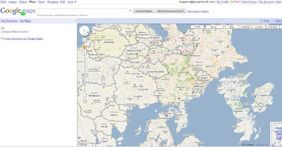
Google Map has now enabled Google Labs experiments that you can now add some nice and useful functionality.

Google Maps Labs Rotated
A new prespective - Note the Map Labels (Text) are correct way up but the map is upsidedown.


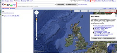
Google Maps Labs New
New Features and Tools in Google Maps via Google Maps Labs - Rotate Map Types (Sat

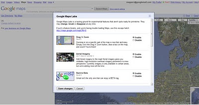
Google Labs experiments that you can now add the following functionality:

Drag 'n' Zoom
Zooming in on a specific part of the map is now fast and easy. Simply click the Drag 'n' Zoom button, draw a box on the map.
Google Maps Labs

Google Maps Labs Drag Zoom
New Button for Drag Zoom - Useful!

Click on the Green beaker New! to access the new features (simliar to gmail labs)

The Options are as follows
Aerial Imagery (Includes Rotate)
Add Aerial imagery to the map! Aerial imagery gives you rotatable, high-resolution overhead imagery presented in a new perspective. Currently imagery is only available in certain areas, but we're adding more all the time.

Back to Beta
Gmail isn't the only one that can enjoy a BETA tag.

Where in the World Game
Test your knowledge of world geography. Guess the name of the country from satellite imagery, and try to beat your top score.

Rotatable Maps
Tired of North always being up? Add rotatable map types and give East, West and South a fair go.

What's Around Here?
Adds a second search button that searches for "*", returning the top results in the current view. A great way to browse the map.

LatLng Tooltip
Displays a tooltip next to the mouse cursor showing the latlng directly underneath it.

LatLng Marker
Adds an option to the context menu that lets you drop a mini marker showing the latlng of the position that the cursor was pointing at when the context menu was evoked.

Smart Zoom
Ever zoom in too far and get the message "We don't have imagery at this zoom level"? Ensure you don't see it again, with Smart Zoom, which will check in advance what imagery exists, and ensure you can't zoom in beyond it.

source:
http://blogoscoped.com/archive/2010-02-12-n86.html
Related
http://googlemapsmania.blogspot.com/2010/02/google-maps-in-google-labs.html
Official Post
http://google-latlong.blogspot.com/2010/02/introducing-google-maps-labs-your.html

Labels: , , , , , ,

10 February 2010

New York Times - 3D Olympic Venues Map

New York Times - 3D Olympic Venues Map

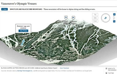
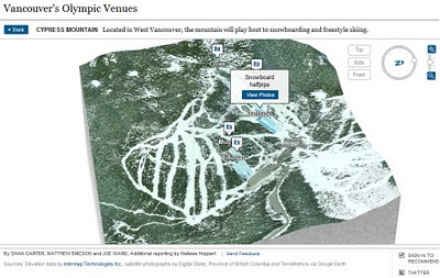
If you want just one map to locate events for the Winter Olympics in Vancouver 2010 then this Interactive and Animated 3D Map created by The New York Times is it.

New York Times Olympic Venues Mapped - 3D Animated
  • Highly Detailed
  • Smooth Animated Zooms to Event Locations
  • Interactive (Users can control 3D aspects panning and zoom)
  • Informative Details on the Sport persons to look out for
  • High Quality Action Photographs.
Clicking from the Map above smoothly zooms to:
New York Times Olympic Venues Mapped - 3D Animated Bobsled
Users can control Aspect using the controls in the top right corner.

New York Times Olympic Venues Mapped - 3D Animated Halfpipe
Using Flash there is a quick response to load up a very impressive 3D Animated Map

Well done to
SHAN CARTER, MATTHEW ERICSON and JOE WARD; Additional reporting by Melissa Hoppert


Sources: Elevation data by Intermap Technologies Inc.; satellite photographs by Digital Globe, Province of British Columbia and TerraMetrics via Google Earth

Visit the New York Times - 3D Olympic Venues Map
http://www.nytimes.com/interactive/2010/02/09/sports/olympics/2010-olympics-venue-map.html


Labels: , , , , , , ,

09 February 2010

New Street View Coverage for Norway & Finland

New Street View Coverage for Norway & Finland

update:
Canada has large coverage updates too
Canada Streetview Expands
New Canadian Coverage (substantial)
Yukon (Whitehorse)
Northewest Terroritories (YellowKnife)
Alberta (example Grande Prairie)
Bristish Columbia (example Prince George) (also includes Snow Mobile Streetview)
Saskatchewan (Example Prince Albert)
Manitoba (Lake Winniepeg)

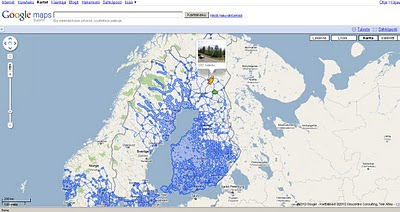
Google Maps Street view Finland
New Suomi (Finland) Street View Coverage

View the New Coverage
and drag the yellow pegman, drop on anywhere that is blue.


Google Maps Street view Norway

Norge (Norwegian) Street View Coverage

View the Norge Streetview


Also available on the Desktop via Google Earth see
http://www.gearthblog.com/blog/archives/2010/02/streetview_added_to_norway_and_finl.html

Source:
http://googlemapsmania.blogspot.com/2010/02/street-view-arrives-in-norway-finland.html

Labels: , , , , , , , ,

05 February 2010

'Eye on Earth' EEA and Microsoft Bing Mapping

'Eye on Earth' EEA and Microsoft Bing Mapping

Green EU citizens are being encouraged to contribute their own environmental observations to a website.

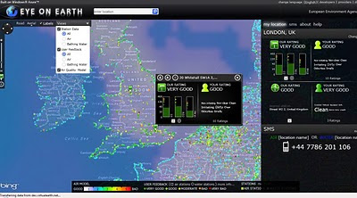
The Eye on Earth platform is a joint venture between the European Environment Agency (EEA) and Microsoft.

Eye On Earth Bing Map

Features:

  • Air Quality
  • Air Quality Model
  • Bathing Waters

1 is Very Good (Dark Green)
5 is Very Bad (Red)

Overlaying Air Quality data from Official EEA sources and from 'user' feedback using Bing Maps.

An impressive language support exists for covering all European Languages.


View Eye on Earth - http://eyeonearth.cloudapp.net/

*The project makes use of Microsoft mapping software and Windows Azure - the "cloud"-based operating system.

Room for expansion:

"The EEA's future ambitions for the site stretch beyond water and air monitoring."

source:

http://news.bbc.co.uk/1/hi/technology/8499059.stm


Labels: , , , , , , ,

04 February 2010

British Geological Survey (BGS) Bedrock Maps

British Geological Survey (BGS) Bedrock Maps

04/02/2009 17.20 update: Apologies if your getting this message
"The bandwidth or page view limit for this site has been exceeded and the page cannot be viewed at this time. Once the site is below the limit, it will once again begin serving as normal. "
This has been more popular than expected @mapperz will find a backup host asap.
04/02/200918.10 FIXED!!! see below for Alternative site.

BGS Bedrock Maps - EnglandBGS Bedrock Maps - Northern Ireland

Attributes of the bedrock can be obtained my click on the coloured polygons

The data has been available from the British Geological Survey (BGS) Website in KMZ (Google Earth) Format, but in this case there is no need to download as have overlayed the kmz files on Google Maps.

*Some users will find the maps slow to load, google does cache kml/kmz files.

For DiGMapGB and related purposes all these rocks are placed in a separate Bedrock theme of information. Wherever possible, they are referred to by their current name; for stratified units this will usually be of lithostratigraphic type. More information on units is available in the BGS Lexicon of Named Rock Units.

Links to the Maps:
http://mapperz.googlepages.com/England_bgskmz.html

http://mapperz.googlepages.com/Northern_Ireland_bgskmz.html (fastest to load)

http://mapperz.googlepages.com/Scotland_bgskmz.html
(slowest to load)

http://mapperz.googlepages.com/Wales_bgskmz.html

Alternative Site:
http://mapperz.110mb.com/GMAP/England_bgskmz.html
http://mapperz.110mb.com/GMAP/Wales_bgskmz.html
http://mapperz.110mb.com/GMAP/Northern_Ireland_bgskmz.html (Smallest)
http://mapperz.110mb.com/GMAP/Scotland_bgskmz.html (Largest)


These DiGMapGB-625 data can be used free of charge for personal, teaching, academic and non-commercial purposes. DiGMapGB data are available in many scales and formats, and for commercial use purposes are supplied under licence on request.

BGS encourages the use of its data for commercial purposes. You may download these DiGMapGB-625 data free of charge to innovate, for mashups, or to develop commercial applications. However, the data remain the property of BGS (NERC). Before launching any commercial services using these data you must therefore either

* arrange a licence permit (contact ipr@bgs.ac.uk), or
* contact using BGSdata@bgs.ac.uk to discuss a collaborative commercial agreement.

Prefer to use Google Earth?
Follow the link below to save the KML files to your PC or choose to open it with Google Earth. Bedrock data is currently made available.
http://www.bgs.ac.uk/data/services/digmapgb625kml.html


Note on the data:
Bedrock geology (formerly known as 'solid' geology by BGS) is a term used for the main mass of rocks forming the Earth and present everywhere, whether exposed at the surface in outcrops or concealed beneath superficial deposits or water. The bedrock has formed over vast lengths of geological time ranging from ancient and highly altered rocks of the Proterozoic, some 2500 million years ago, or older, up to the relatively young Pliocene, 1.8 million years ago.

Source:
http://www.bgs.ac.uk/products/digitalmaps/digmapgb.html

Labels: , , , , , ,

01 February 2010

FREE the PostZon (UK Postcode Data)

From the Free Our Data Blog:

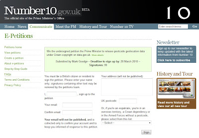
A new No.10 petition: FREE the PostZon and help innovate the UK Geo-spatial industry

(We are in 21st Century now aren't we?)

Mark Goodge added this as a comment to the data.gov.uk post, but it seems worth making more visible. So here it is:

This is not asking for Full Postcode (PAF) data but This is about Ordnance Survey's data, not Royal Mail's -- so it won't affect PAF, but it will affect postcode coordinate data.

"Postzon™ data allows you to link geographic and administrative data from government bodies, such as local authorities and the NHS, for all known Postcodes in the UK. Use it to help plan routes, calculate distances between Postcodes, allocate sales force areas, distribute resources or locate facilities."

http://www.royalmail.com/portal/rm/jump2?mediaId=400088&catId=400084

Without this, UK mapping innovation will be quashed.

Number10 Geolocation Postcode Petition

http://petitions.number10.gov.uk/geopostcode/ requires your input 28 March 2010 deadline (note: OS Consultation period deadline is 17th March 2010).

“While the launch of data.gov.uk is a big step in the right direction, the government’s response to the petition inspired by the forced closure of ernestmarples.com has been pathetic. As a consequence, I’ve created a new petition which seeks to focus more tightly on the Postzon data (the data use by ernestmarples in their API)." This can be found at http://petitions.number10.gov.uk/geopostcode/

http://ernestmarples.com/blog/

http://www.freeourdata.org.uk/blog/2010/01/a-new-no-10-petition-free-postzon/

Help free the data that was paid for by the public (UK tax payer)...

Labels: , , , , ,