->

15 April 2011

London Marathon 2011 Map

London Marathon 2011 Map

London Marathon 2011

London Marathon Map 2011 - with StreetView

Racing starts 9.00am BST on Sunday 17th April 2011

9am Elite Women's Race Starts
9.25am Wheelchairs Race Starts
9.45am Elite Men's Race Starts
9.45am Mass Race Starts

London Marathon Map 2011 - Now with StreetView
Runner and Spectators can use the map to find locations around the course.
Use the interactive Timeline Bar to find out when lead runners go past.
Streetview is available now to view the location also.

London Marathon Map 2010 - Legend

Look out for Crowd Density Mapping - live on the race day

http://www.virginlondonmarathon.com/interactive-map/

One New change from last years 2011 map are
Road Closures are now included on the Interactive


Official Site:

http://www.virginlondonmarathon.com/

Interactive Map
http://www.virginlondonmarathon.com/interactive-map/

Labels: , , , ,

30 September 2010

TripGeo - Directions with Video Streetview

TripGeo - Directions with Video Streetview

"If you need a directions widget for your business, school or college you could do a lot worse than embed a free Directions Map widget on your website. TripGeo Directions uses Google Maps to help users create an embedable driving directions map for their website or blog.

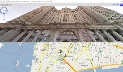
TripGeo - Directions with Video Streetview  NYC

The really fun part of this Google Maps based widget however is that it also allows you to create animated Street View tours. If you just add a starting point and a destination to Directions Map you can then view the route entirely in Street View.

Directions Map allows users to create driving directions from any starting point to any location. Users can also define the height, width and the map type of their widget. Once the widget has been embedded on a website it can then be used to follow the given driving directions or to view an animated walk-through of the route in Street View.

The animated walk-throughs of routes with Street View are very impressive. Given the impressive nature of these Street View animated routes I can see Directions Map also being used by websites to create virtual tours. In fact Directions Map has created a number of example animated Street View routes for locations around the world."
TripGeo - Directions with Video Streetview
Glide along with directions and video streeview (click play).
Here are links to some of the example animated Street View routes:

Chapmans Peak Drive, South Africa
Chateau d'Eox , Switzerland
Golden Gate Bridge
Colosseum, Rome
Las Vegas Boulevard
London, from the Houses of Parliament to the British Museum

Because Directions Map uses dynamic URL's you can even play about with the web address to quickly create your own routes by changing the start point and destination in the URL.

Here is the URL for New York to Boston:

http://s3.tripgeo.com/dirmap/map.htm?from=New%20York&to=Boston


If you want to view a Street View animation of the route from New York to San Francisco just change 'Boston' to 'San Francisco in the URL above. So what routes can you create. Post links to your routes in the comments below.

Update: microformats.dk has quickly created a page combining a Directions Map Street View tour of the Alpe d' Huez with a Kraftwerk YouTube video. Superb!

cross-posted from Google Maps Mania

Labels: , , , , ,

26 August 2010

Map Channels - Location Maps

Map Channels - Location Maps
*Using Google Maps API v3

Location Maps are simple controls to display a map of a single location. Street View can optionally be shown with the map.

Location Maps use the
Google Maps v3 API and are provided free for commercial or non-commercial use.

No adverts are included in Location Maps. An 'embed' control links from the map to this page.


Control size, maptype, map controls, markers and more with the new Location Maps which utilizes the fast v3 of Google Maps API.

Technical Notes:

You may copy the embeddable Location Map HTML Page to your own website (change the url used within the embeddable HTML code).

• Location Maps use the new Google Maps v3 API. This is more compact so loads faster.
• No API Key is needed for the Google Maps v3 API.
• The Street View is displayed without using Flash so no browser plugins are required.
• The 'fullscreen view' option included with the v2 API is not available. To see a larger street view click on the Google logo to see the street view at maps.google.com.

Full API reference can be found here http://www.mapchannels.com/LocationMaps.aspx#api


Labels: , , , , , ,

08 June 2010

South Africa Google Streetview Released

South Africa Google Streetview Released

update: now available at http://maps.google.co.za/
South Africa Google Streetview Released
South African Streetview Coverage

Just in time for the Football World Cup 2010.

But don't forget the scenery like this


Official Post:
http://google-latlong.blogspot.com/2010/06/street-view-brings-taste-of-south.html
View Larger Map

Labels: , , , , , ,

20 April 2010

London Marathon Map 2010 - Now with StreetView

London Marathon Map 2010 - Now with StreetView

Racing starts 9.00am BST on Sunday 25th April 2010

9am Elite Women's Race Starts
9.25am Wheelchairs Race Starts
9.45am Elite Men's Race Starts
9.45am Mass Race Starts

London Marathon Map 2010 - Now with StreetView
Runner and Spectators can use the map to find locations around the course.
Use the interactive Timeline Bar to find out when lead runners go past.
Streetview is available now to view the location also.

London Marathon Map 2010 - Legend
Look out for Crowd Density Mapping - live on the race day

http://www.virginlondonmarathon.com/interactive-map/


Road Closures [pdf]
http://static.london-marathon.co.uk/downloads/pdf/road_closures_2010.pdf

improvement on last years map (2009)
http://mapperz.blogspot.com/2009/04/london-marathon-maps-2009.html

Labels: , , , ,

09 February 2010

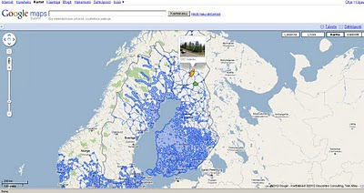
New Street View Coverage for Norway & Finland

New Street View Coverage for Norway & Finland

update:
Canada has large coverage updates too
Canada Streetview Expands
New Canadian Coverage (substantial)
Yukon (Whitehorse)
Northewest Terroritories (YellowKnife)
Alberta (example Grande Prairie)
Bristish Columbia (example Prince George) (also includes Snow Mobile Streetview)
Saskatchewan (Example Prince Albert)
Manitoba (Lake Winniepeg)

Google Maps Street view Finland
New Suomi (Finland) Street View Coverage

View the New Coverage
and drag the yellow pegman, drop on anywhere that is blue.


Google Maps Street view Norway

Norge (Norwegian) Street View Coverage

View the Norge Streetview


Also available on the Desktop via Google Earth see
http://www.gearthblog.com/blog/archives/2010/02/streetview_added_to_norway_and_finl.html

Source:
http://googlemapsmania.blogspot.com/2010/02/street-view-arrives-in-norway-finland.html

Labels: , , , , , , , ,

14 December 2009

Mapquest Streetview (called 360) - Street Level Imagery

Mapquest Streetview (called 360) - Street Level Imagery
Mapquest Steetview 360
You can now view MapQuest Maps in a whole new way. We have developed a simple, easy-to-use interface that fits seamlessly into the MapQuest mapping experience you have come to know and understand. 360 View provides fantastic panoramic views (360° horizontally and 160° vertically) of any given image within the 360 View coverage area
*selective USA Cities only
Mapquest Steetview 360 mode
orange glow represents 360 street level imagery available when the '360 view' option is on.

The quality of the imagery is not as high resolution as Google (Streetview) or Bing Streetside but then they require post-processing bluring faces, mapquest does not.
The Orange 'bubbles in' 360 mode could be made transparent but do indicate direction of the next photo in a simple manner.


Mapquest API
currently 360 mode is not available in the mapquest api
http://developer.mapquest.com/web/products/beta-releases

source:
http://blog.mapquest.com/2009/12/11/street-level-imagery-comes-to-mapquest-com-as-360-view/
screen shots:
http://www.mapquest.com/360-details

Labels: , , , ,

02 December 2009

Big Street View Update for Canada

Big Street View Update for Canada

Street View Canada update Victoria & Nanaimo
Canada has had a large update of Street View - Victoria, British Columbia is new
along with

Edmonton, Saskatoon, St. John’s, Winnipeg, Victoria.


Small update for United Kingdom
Eden Bio-domes Streetview Coverage
Kew Gardens
Warick Castle
EDEN Project
Stonehenge
ITV [UK TV Channel] have 'Coronation Street'

Sources
http://www.mcwetboy.net/maproom/
http://maps.google.ca/
http://maps.google.co.uk/

official post
http://google-latlong.blogspot.com/2009/12/more-street-view-updates-see-sea-see.html

updates throughout the day at http://twitter.com/mapperz

Labels: , , , , , ,

08 October 2009

Google StreetView for Canadian Cities - New!

Google StreetView for Canadian Cities - New!

Seems a long time waiting but finally Google Street View comes to Canada.
Google Street View Canada

The service is now available in much of the Greater Toronto Area and in Vancouver and the surrounding area, north to Whistler (2010 Winter Olympics Venues) and east to Chilliwack, British Columbia


Google Street View is also available in the Ontario cities of Hamilton, Kitchener, Waterloo, Ottawa also Calgary, Canmore, Banff and Lake Louise in Alberta, Montreal and surroundings, Quebec City and finally Halifax in Nova Scotia.


Source and embedded StreetView Scenes available at
http://googlemapsmania.blogspot.com/2009/10/street-view-comes-to-canada.html

Don't forget you can embedded your own StreetView tours easily with
http://www.streetcities.com/

Labels: , , , , , ,

14 April 2009

Dual Maps Version 3

Dual Maps Version 3


Panda watching cricket - Dual maps Version 3
Features:
  • Dual maps combine Google Maps, Google Street View and Microsoft Virtual Earth into one embeddable control.
  • Free to use, no registration required.
  • Many customizable settings
  • New: View Google Search results in Street View (where available)
  • New: Option to supply an address instead of co-ordinates to generate a Dual Map.
  • New: Choose your street view icon:
    Car

    Peg Man

    Leprechaun

    Panda

    Gachapeg

Labels: , , , ,

10 April 2009

Google Maps Mobile [version 3.0.1.4]

Google Maps Mobile [version 3.0.1.4]

Google Maps Mobile version 3.0.1.4
A minor update but with a few changes.

Most noticable when you search the result animate [drop in markers] to the area.

New Users to Google Maps Mobile can have the following in thier pocket:

Public Transport
Public Transport - can change times starting off.

Send as SMS - Text Message
Meeting a friend? You can send them the map where to meet.

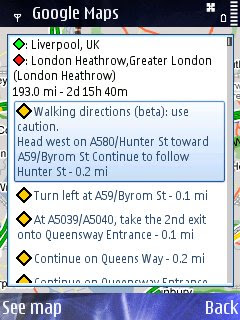
Walking Directions Beta
Walking Direction improved - Not really walking Liverpool to London Heatherow but just a good test - seems faster to calculate in prevoius versions.

Street View Mobile with route
StreetView Mobile - again seems much quicker and also displays your route [pegman guides you].

Available via - http://www.google.com/mobile/


Source:
http://www.allaboutsymbian.com/news/item/9286_Google_Maps_for_Symbian_update.php


Labels: , , , , ,

18 March 2009

Google Street View UK Launched

Google Street View UK Launched

Official Post on this:
http://google-latlong.blogspot.com/2009/03
/street-view-cures-homesick-blues.html

See 'Street View Plus' in action
http://mapperz.googlepages.com/Marble_Arch_Streetview_Plus.html
blog post:
http://mapperz.blogspot.com/2009/03/uk-street-view-plus.html
recommended by:
http://googlemapsmania.blogspot.com/2009/03/street-view-plus.html

Update 19/03/2009
A First UK Google Street View Mashup? "A Quick Drive Through Clifton Bristol"
**now mentioned on the The Guardian by Richard Wray**

Bristol Google Street View UK By Mapperz
http://mapperz.googlepages.com/Bristol_StreetView_UK.html
"On the way in to the UK launch of Street View, Kudos to @Mapperz for the first Mashup within a hour !"
Google's Geospatial Technologist
http://twitter.com/edparsons

Google UK StreetView Launched
http://maps.google.co.uk/ and drag pegman on the map


View Larger Map

Mapperz

Labels: , , , ,

01 December 2008

Google launches Street View in New Zealand

update: 02/12/2008
Also available in the Google Maps API
Mapperz quick attempt
http://mapperz.googlepages.com/nz_street_view.html


Official Google Posts now available
http://google-latlong.blogspot.com/2008/12/new-zealand-new-street-view.html

and more information from the Official Google Australia Blog (News and notes from Google Down Under)
http://google-au.blogspot.com/2008/12/street-view-now-in-new-zealand.html


New Zealand Streetview in Google Earth
also available in Google Earth - see http://www.gearthblog.com

Google launches Street View in New Zealand
- New!

Pegman shows you the StreetView Coverage
The coverage of New Zealand Streetview - Pegman shows you the full coverage (every road in New Zealand)

http://maps.google.co.nz/

(officially launched on 2nd December 2008 - but remember New Zealand is 12 hours ahead of the UK!)

Street View New Zealand
(image source : computerworld.co.nz)

"The imagery was collected by a team of Googlers who travelled all over New Zealand to document every single public road in the country over the past year. The team drove Holden Astras, which had cameras mounted on a pole on the roof. "


Tourism New Zealand has selected a gallery of Street View images, available at maps.google.co.nz/streetview, that shows some of New Zealand's most popular tourist attractions and locations to the world.

source and images
http://computerworld.co.nz/news.nsf/news/A3071103626A25F9CC25751200166B37

Labels: , , ,