->

31 August 2010

The Future of Mobile Maps - Upnext

The Future of Mobile Maps - Fluid Mapping from Upnext

Today Upnext have launched their new iPad app with Fluid Labels.


Seamless integration with 3D Mapping, Map Overlays, real-time content.

The label system is now optimized for the iPad size. When you perform a search, multiple results populate the screen. As you move around the map, the results, smartly, refresh to give you more venues.

Category search or try using the Foursquare Friends checkins to really see the labels in action.

There are a couple more changes in this version. The Venue Info window has been enlarged and reformatted. Editorial and user reviews are now spread out in an elegant layout.

source:
http://techcrunch.com/2010/08/30/upnext-ipad-fluid/

Labels: , , , ,

12 August 2010

Sports Tracker 3.5 Released

Sports Tracker 3.5 Released

Sports Tracker
The Award winning FREE Sports Tracker Application gets an update along with revamped web service for viewing and sharing your routes.

"The newly launched online service allows users to store, visualize and analyze their workouts with enhanced tools, as well as share their media enhanced workout experiences with other Sports Tracker users - and the whole world. The online service also allows existing Nokia Sports Tracker Beta users to import their workout history to the new service.

The Sports Tracker mobile application has also been updated to support uploading of tracked data to the new service and direct sharing to Facebook. The update also extends the list of compatible devices to cover more than 50 device models."

Testing the New Sports Tracker:
Sports Tracker 3.50 Mapping GPS Routes
Mapperz has tested this and the services along with the phone application works seamlessly together.

With the FREE Sports Tracker application mobile phone becomes a full-featured GPS sports computer, keeping track of everything from calories burned while running to your average cycling speed over altitude. You get maps, time and distance calculators, step count, and even heart rate when you use a compatible Polar HR belt. You can chart your progress, find your strengths and weaknesses, and share with others.

The new mobile application allows users to:
  • Record activities with all the data needed to analyze the performance, including distance, speed, duration, route, step count and more.
  • Check their location on the map while running, cycling, walking or with any other outdoor activity, using Open Street Map as a map based (can be cached for offline use)
  • Upload their activity data from their phone to the Sports Tracker service
  • Share their activities and automatically geo-tagged photos with other users and friends on Facebook, directly from their phone
  • Optional with Heart Monitor - Record heart rate data by connecting the Polar WearLink®+ transmitter with Bluetooth® heart rate belt by Polar (€70 or $90USD)
  • Automatically compare speed, distance and duration of recorded activities


Get it here:
http://www.sports-tracker.com/

With this Launch Ovi (Nokia) are having a competition:


GPS Trace from Skating
Create your own shape and enter for a prize. Image: Ovi Blog

"What we’re asking you to do is simply this: make a funny or interesting shape with your Sports Tracker workout, share it publicly in the service and send a link of the shared workout to us."
For more information on this competition and what can be won go here:
http://blog.ovi.com/2010/08/12/sports-tracker-ovi-competition-launches-now

Labels: , , , , , ,

29 January 2010

Mobile GeoRSS Maps *Beta* (Map Channels)

Mobile GeoRSS Maps *Beta* (by Map Channels)

"The easy way to add mapping for mobile websites"

Mobile GeoRSS Maps combines the Google Maps v3 API and Google Feeds API to display a GeoRSS feed on a map that is optimized for mobile phone display.
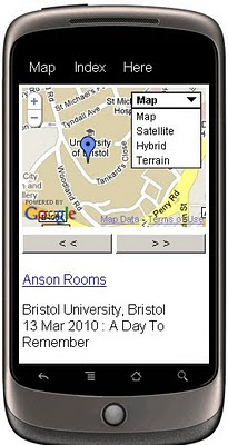
Mobile GeoRSS Maps
Create your own Map with feeds for your mobile, mymaps or georss feeds can auto-update and provide you with latest information whilst on the move.

Use Mobile GeoRSS Maps to simply add your map to your mobile website, or to generate a map link for emailing.

Google My Maps are supported. Use Mobile GeoRSS Maps to generate a mobile version of a My Map in seconds.

Mobile GeoRSS maps works on any phone which supports the Maps v3 API, such as the iPhone and Android or Symbian platforms.
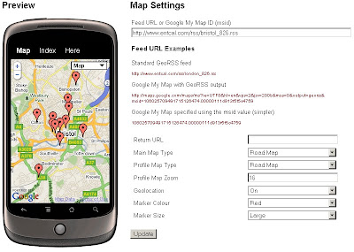
Mobile GeoRSS Maps Preview
Simple instructions to set you up for adding your own feeds to your mobile.

Technical Notes:

This map is a *beta* project, please contact us if you notice any bugs.

Only placemarks in a feed are displayed (lines and polygons are not displayed)

A maximum of 200 placemarks are displayed on the map

Custom Marker styles contained in a My Map are not displayed

base url for the following parameters
http://data.mapchannels.com/mobmap/100/map.htm

f = Feed URL or My Maps ID
r = Return URL
mt = Main Map Type (1=Road Map, 2=Satellite, 3=Hybrid, 4=Terrain)
pt =Profile Map Type (1=Road Map, 2=Satellite, 3=Hybrid, 4=Terrain)
z =Profile Map Zoom (between 1 and 20)
g =Geolocation (0=Off 1=On)
c =Marker Colour (0=Red 1=Blue 2=Green 3=White)

example:
http://data.mapchannels.com/mobmap/100/map.htm?g=1&mt=1&pt=1&z=16&c=0&s=1&f=http://www.entcal.com/rss/bristol_826.rss&r=
(will appear a full page map on a web browser)

Try it out here
http://www.mapchannels.com/MobileGeoRSSMaps.aspx

Nice, clean simple you set up and use, good work by the Map Channels keep up with developments at http://www.mapchannels.com/News.aspx

Labels: , , , , , , , ,

30 October 2009

Google Maps JavaScript API v3 - Now with Directions

Google Maps JavaScript API v3 - Now with Directions

**Remember Google Maps JavaScript API v3 is designed to be super lightweight for mobile devices

This makes mapping for mobile devices a lot more useful

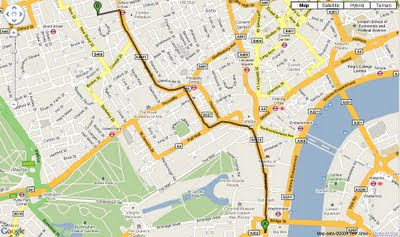
New Directions (Walking or Driving) in London - Google Maps API V3
New Directions (Walking or Driving) in London - Google Maps V3

@mapperz example above
http://mapperz.googlepages.com/google_mapv3_directions.html

With a Directions Panel
http://mapperz.googlepages.com/google_mapv3_directions_panel.html


Code:
New required parameters

var directionDisplay;
var directionsService = new google.maps.DirectionsService();

Set Start and End locations:

function calcRoute() {
var start = document.getElementById("start").value;
var end = document.getElementById("end").value;
var request = {
origin:start,
destination:end,

Travel Modes:

travelMode: google.maps.DirectionsTravelMode.WALKING
travelMode: google.maps.DirectionsTravelMode.DRIVING

Get the response from the Geocoder if both locations geocoded then display route between locations:

directionsService.route(request, function(response, status) {
if (status == google.maps.DirectionsStatus.OK) {
directionsDisplay.setDirections(response);


See the changelog
http://code.google.com/p/gmaps-api-issues/wiki/JavascriptMapsAPIv3Changelog

revelant links
Official documentation
http://code.google.com/apis/maps/documentation/v3/reference.html#DirectionsRenderer
http://code.google.com/apis/maps/documentation/v3/reference.html#DirectionsService

Offical Examples:
http://code.google.com/apis/maps/documentation/v3/examples/directions-simple.html
http://code.google.com/apis/maps/documentation/v3/examples/directions-panel.html

source:
http://groups.google.com/group/google-maps-js-api-v3/browse_thread/thread/ee7ce7cf8a872268?hl=en#

Labels: , , , , , ,

01 September 2009

Portable GIS v2 Released

Portable GIS v2 Released

"Mobile GIS in your pocket - all you need on one USB Stick - *Portable GIS v2"
*mapperz recommends

Portable GIS v2 Suite

If you want a fully featured GIS suite that works portably from a USB stick in Windows, that can be rapidly deployed and used anywhere in the world, and comes with full setup and support, then this is for you.

Key Advantages:

  • Work remotely in the field, and synchronise your data when you return to the office.
  • Rapidly deploy pre-configured GIS data and software packages.
  • Showcase your work at conferences, seminars and presentations.
  • No licensing issues, no matter how many copies you deploy.


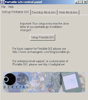
Portable GIS V2 - Control Panel
The new Portbable GIS v2 Control Panel


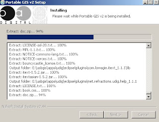
Installing Portable GIS v2 (on USB Stick)
Easy installing - and your be up and running in minutes.


What goes on the USB Stick (2GB stick required)

Included software (with versions)
uDig (1.1.1)
GvSIG (1.1.2)
Quantum GIS (1.02)
PostgreSQL (8.4.01)
PostGIS (1.4.0)
Xampplite: PHP, MySQL, Apache (1.6.2)
Geoserver (1.7.6)
FWTools: ogr, gdal, python, mapserver, openEV (2.4.2)
Tilecache (2.10)
Featureserver (1.12)
PgAdmin III (1.10)
OpenLayers (2.8)

The following utilities are also included:
SqlSync (cross-platform database synchronisation)
GeoMetadataExtractor (extracts metadata from georeferenced images)
Shp2Text (converts shapefiles into csv, with coordinate columns)
Ogr2Gui (GUI for OGR toolkit)
ShapeChecker (Checks and fixes corrupt shape files)


Desktop Modules - Portable GIS
Control Panel give users fast access to Setting Up, Desktop and Web Modules

Full Credit to archaeogeek who has made this make GIS much more portable and easier to use for all levels of GIS knowledge. Well done and many thanks.

Source:
http://www.archaeogeek.com/blog/2009/09/01/portable-gis-version-2-released/

additonal links:
http://oadigital.net/software/pge


Labels: , , , , , , ,

09 July 2009

Ericsson Web & Mobile Maps API (Labs)

Ericsson Web & Mobile Maps API (Labs)

Use Web Maps to embed powerful and flexible maps into your web applications.

  • Powerful map component easily embeded into any web page
  • Custom layers with your own objects and symbols
  • Embedded Java Applet with dynamic map rendering in the browser
  • Easily integrated Javascript interface
  • Automatic fall back to Javascript only version for browsers that doesn’t support Java Applets
  • Free access to map data (TeleAtlas - Vector data)

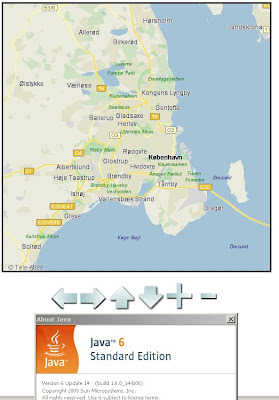
Ericsson Web Maps - Java

The Ericsson Web Maps API (Labs) uses Java for the mapping (javascript- fallback if no java available), first load can be a little slow at times.

Working Example

http://saudi.betainnovation.com/controls.html

Web Maps provide dynamic maps which you can integrate into any web application and features a large variety of control possibilities and overlay of symbols. The maps are rendered in a Java Applet which provides fast map browsing and smooth and animated interaction.

The dynamic rendering also let’s you control the look and feel of the map and how your users interact with it.

Currently limited in Mapping Examples. Users would be encouraged to create their own.

More information on the Web Maps API:

https://labs.ericsson.com/apis/web-maps/documentation

Mobile Version (also with an API)

"Mobile Maps is Java based and available both for Java ME and for Android. You download the Java ME or Android library, which provide the functionality of downloading, displaying, and interacting with maps to your applications. It also includes access to the map data itself."

Key Point with the Mobile Maps Version is:
"Through its unique functionality of rendering the maps in the mobile phone application Mobile Maps use very low bandwidth in comparison to many other map services and applications."

Mobile Maps is powered by Idevio and Tele Atlas


More information
https://labs.ericsson.com/apis/mobile-maps/

Source: (Also mentions the new SMS Send & Receive API)
http://blog.programmableweb.com/2009/07/04/5-new-apis-sprint-ericsson-and-volunteerism/

Labels: , , , , , , , ,

09 June 2009

Cloudmade 'Fast Maps' with KML Overlay

Cloudmade 'Fast Maps' with KML Overlay

"Using the web maps lite API you can achieve lightening fast maps"

CloudMade's Web Maps Lite API lets you embed our maps in your website.
Using our JavaScript API you can:
  • Take advantage of the most up-to-date source of map data on the web
  • Benefit from the rich OpenStreetMap dataset, with features such as footpaths and cycle paths that are not found on other online maps
  • Be free from restrictive licensing - use our maps for routing, real time tracking and as a basemap to derive new layers.
Now you can overlay your KML on these fast maps with very little programming or issues.

CloudMade Fast Maps with KML Overlay
Fast Maps for Mobile and Web Mapping Applications - With KML Overlay
http://mapperz.googlepages.com/cloudmade_kml.html

Note: Web Maps Lite is available is now out of developer pre-Alpha

Google Maps API does not current have the superfast maps (Google Maps API v3 'in labs')
with the KML Overlay option, so this is currently Mapperz recommended route for fast mapping (with mobile applications) and overlaying your own data.


Source:
http://developers.cloudmade.com/projects/web-maps-lite/examples

Labels: , , , , , ,

03 June 2009

Bing Maps for Mobile (with directions)

Bing Maps for Mobile (with directions)

related update: Just released!
Bing Maps 3D -
http://tinyurl.com/Bing-Maps-3D
(though it is/was the same as Virtual Earth plugin just renamed)
source:
http://www.microsoftwindowsos.com/bing-maps-3d-has-been-released


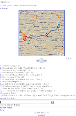
Bing Maps for Mobile (Cell) Phone is now available with Driving Directions and Walking Directions.

Bing Maps for Mobile Devices
Clean and Simple -Very fast response for Mobile devices.


There seems to be a neat function that it takes traffic information and applies it to the outcome or at least a warning of possible delays.

It is possible to test this function on a normal web browser

Other features are available (weather, local information etc.) from http://m.bing.com/

here is the link

http://tinyurl.com/BingMapsMobile

Labels: , , , , , ,

10 April 2009

Google Maps Mobile [version 3.0.1.4]

Google Maps Mobile [version 3.0.1.4]

Google Maps Mobile version 3.0.1.4
A minor update but with a few changes.

Most noticable when you search the result animate [drop in markers] to the area.

New Users to Google Maps Mobile can have the following in thier pocket:

Public Transport
Public Transport - can change times starting off.

Send as SMS - Text Message
Meeting a friend? You can send them the map where to meet.

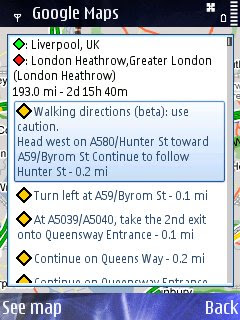
Walking Directions Beta
Walking Direction improved - Not really walking Liverpool to London Heatherow but just a good test - seems faster to calculate in prevoius versions.

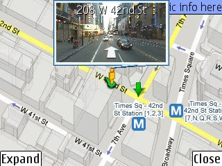
Street View Mobile with route
StreetView Mobile - again seems much quicker and also displays your route [pegman guides you].

Available via - http://www.google.com/mobile/


Source:
http://www.allaboutsymbian.com/news/item/9286_Google_Maps_for_Symbian_update.php


Labels: , , , , ,

04 February 2009

Google Maps Mobile Version 3 - With Latitude

Google Maps Mobile Version 3 - With Latitude

Join Google LatitudeGoogle Maps Mobile V3 with  Latitude
Easy to install and easy to use - if you have a google account.

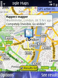
Locate with Google Latitude Active
Not Competley Invisable now you have been spatially found.

Google Maps for Mobile v3.00 is now available to download.
Google Latitude, a spatial way to find your friends/contact on the map.

Google Maps v3.00 download (mobile/cell users only)
m.google.com/maps
Non-mobile users will be directed to
http://www.google.com/mobile/default/maps.html

Mapperz tested and installed on a Nokia N82 - without any issues.

Go Play - Go locate..

Source and More Information
http://www.allaboutsymbian.com/news/item/8887_Exclusive_Google_Maps_for_Mobi.php

Labels: , , , , ,

Introducing Google Latitude - New!

Introducing Google Latitude - New!

See where your friends are in 'real-time' on a Google Map
Locate your Friends/Contacts

Google Latitude - Map- New!
iGoogle gadget can be used to locate friends in your gmail contacts
(contacts are emailed first for permission to be located)


"Enjoy Google Latitude on your phone, computer, or both."

Share locations
Location sharing starts only when both you and a friend agree. Invite friends via email or easily add them from your Gmail contacts.

Control privacy
You can share, set, or hide your location - or turn off Google Latitude - from the privacy menu. You can also hide your location or share only a city-level location with certain friends. For more information, see the Privacy FAQs.

Share status
Create a status message and upload your photo within Latitude. It also syncs directly with Google Talk. Check your friends' status messages to see what your friends are up to.

Contact your friends
Quickly contact your friends with an SMS, IM, or phone call. You can also get directions to lead you to your friends.

Location Privacy

A useful guide is here
http://www.google.com/support/mobile/bin/topic.py?topic=19501

more on Google Latitude
http://www.google.com/mobile/default/latitude.html

Google Maps Mania has a good introduction into the new service

mobile access starts here
visit google.com/latitude

Official Post
http://googleblog.blogspot.com/2009/02/see-where-your-friends-are-with-google.html

"It is a Location Based Service made 'cool' by Google"
Mapperz

Labels: , , , , , ,

16 January 2009

Bird's Eye View on Windows Mobile

Bird's Eye View on Windows Mobile

Bird's Eye option Windows Mobile 6 - London
Finally Microsoft have made Birds Eye View available on a Mobile Platform - Windows Mobile 6.

Select Bird's Eye Mode
Available in the Menu and Bird's Eye Mode option
*Bird's Eye View is not available everywhere - though most large cities in the USA/Canada/Europe/Australia regions will have Birds Eye oblique aerial photographs.

Hopefully soon this will be made available to all other platforms.

Microsoft Windows Mobile 6 Users
wls.live.com

other mobile users without Microsoft Windows Mobile
m.live.com
(no birds eye view mode/content yet)

Mapperz does not have Windows Mobile 6 and likely not too but if you want to test it try the emulator:
You will need
Microsoft Active Sync
Device Emulator Manager
Windows Mobile 6 Professional SDK

Help and useful guide:
http://www.lancelhoff.com/how-to-emulate-windows-mobile-6/

Source:
http://www.livesearchmobile.com/

Labels: , , , ,

19 September 2008

Google Street View on Nokia Phones (N82)

Google StreetView on Nokia Phones (N82)

As Google have released v2.3.1 of Google Maps Mobile
It is now possible to access 'StreetView' and 'Walking Directions' on Mobile Devices

Here is the new Streetview functionality on a Nokia N82

StreetView on Nokia N82
Street view (screen shot from a Nokia N82 here) is new to mobile devices but there is huge data transfers (2000k+) so make sure you have access to wifi or an unlimited data plan (3G/GPRS)
*Expand button makes streetview full screen.
The images are large (in terms for mobile devices) and a little grainy when panning around but does sharpen up when paused.

The .jar install file is available from
http://m.google.com/gmm/apps/v2.3.1/L1/gmaps-231-m2_L1.jar
Thanks to http://www.allaboutsymbian.com/

Labels: , , , ,

22 May 2008

Nokia Maps 2.0 Goes Mainstream

Nokia Maps 2.0 Goes Mainstream

Finally after many months of 'Beta' status the Nokia Maps 2.0 has made it available to the normal users.
Nokia Maps 2.0 Goes Mainstream
So whats changed?
Well from version 1.0 lots but from the 2.0 beta version not very much (a few bugs)

A quick summary:
Car Navigation
Pedestrian navigation
Multimedia city guides

Car Navigation has navigation carousel with three pre-defined navigation views (navigation, arrow and bird-eye) with multi-stops route planner.

(Purchase required based on region 3 day, 1 month, 1 year subscriptions - there is a option for 3 days free trial - this now tied to the SIM card not the IMEI of the Phone - meaning if you change your phone you can keep you licence.)
SIM to SIM licence copying can be done.

Satellite images
Hybrid mode


**Note these two modes use either Wifi or GPRS for displaying the layer they DO NOT come with the MapLoader pre-installed onto a memory card.

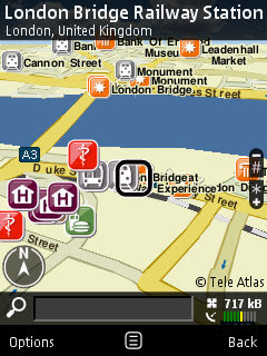
Nokia Maps 2.0 Goes Mainstream - London Bridge

Nokia Maps 2.0 uses digital vector data provided by Navteq and TeleAtlas
Either download directly to the nokia device or by using the Nokia Map Loader on a PC. Nokia Maps 2.0 and the current commercial version of the Nokia Maps Loader are freely available for selected devices.

Downloads
Nokia Maps 2.0
http://europe.nokia.com/A4984199
(select your device)

Nokia Map Loader v1.3.8 (for Vista/XP on the PC - use this to save money on data transfer fees)
If your feeling brave there is a new beta version of Nokia Maps 2.0

Created Feb. 11, 2008 but updated on May 08, 2008
nokia_maps_2.0_1803_3.1_u.sis
http://www.nokia.com/betalabs/applications


Other Nokia useful applications recently released.

Nokia Step Counter
Nokia Step Counter New! [Free]
Every step you take

Location Tagger (Updated) [Free]
http://www.nokia.com/betalabs/locationtagger

Mapperz

Update of Nokia Maps 2.0 source:
http://www.infosyncworld.com/news/n/9390.html

Labels: , , , ,

25 April 2008

The Future of Mobile Mapping? (Location Based Services)

The Future of Mobile Mapping?

"location-based content in a unique way that bridges the gap between reality and classic map-like representations"


Enkin from Enkin on Vimeo.


Two Uber Mappy Geeks show you a glimpse of Mobile Mapping in the near future.

This is one for the Google Android Developer Challenge

Found via

http://blog.wired.com/sterling/2008/04/enkin-is-the-li.html

via http://www.thefutureisawesome.com/

via browsing

http://edparsons.com/

More info on Location Based Services (LBS)

http://en.wikipedia.org/wiki/Location-based_service

Labels: , , , , , ,

10 February 2008

Carmenta Mobile (N95)

Carmenta Mobile
'The future of maps in mobile phones'


"Carmenta Mobile is a high performance map engine for mobile phones, targeting companies that want to provide advanced Location Based Services applications around maps, routing and geocoding"

Carmenta Mobile can be easily embedded into a mobile application as it provides a rich set of features such as:

  • 2D and 3D maps with 3D buildings and landmarks
  • Onboard and/or offboard (loaded from server) maps
  • Maps as images or vector data
  • In-car personal navigation
  • Pedestrian personal navigation
  • Friend finder
  • Proximity search, “where is the closest restaurant from my location”
  • Location based games
  • Tracking
  • Fleet management

video: http://www.youtube.com/watch?v=iBGvkmmSkWI

http://www.carmenta.com/company is a company producing high-class geospatial software products.

Labels: , , , , ,

08 January 2008

Yahoo! Go 3.0 (Beta) with Maps

Yahoo! Go 3.0 (Beta) with Maps

Yahoo Go 3.0 Beta


Yahoo! Go 3.0 services:

  • oneSearch
  • Yahoo! Calendar
  • Yahoo! Address Book
  • Yahoo! Local
  • Yahoo! Maps
  • Yahoo! News
  • Yahoo! Sports
  • Yahoo! Finance
  • Yahoo! Entertainment
  • Yahoo! Weather
  • Flickr
  • Yahoo! Mail

"Yahoo! Go 3.0 connects your device to these Yahoo! services in real time. You can manage your contacts on the device and changes are synchronized with your Yahoo! account. The application uses widgets to display information from your Yahoo! services. Download provides a basic set of Yahoo! Go 3.0"

Yahoo Go 3.0 Map Search

Local & Maps searches for and provides information and images specific to a location or business. The results of the search show up on the display as a

map with pinpoint links to a list of items including:
  • web sites
  • mobile-friendly web sites
  • businesses with addresses, telephone numbers, driving directions, maps, and ratings and reviews

Results will vary based on what you search for and the location set. Local & Maps remembers the last location mapped so that you can get the information again immediately.

Other ways to get information relevant to a location are listed at the Local & Maps position of the carousel:

  • Map View for the location at the top of the display
  • City guide about places to eat, drink, stay, visit, shop and more
  • Find nearby... with lists of categorized goods and services
  • Driving directions for turn-by-turn instructions for getting from A to B
  • Traffic Watch where you can check traffic incidents for your location and for special routes you define.

*Local & Maps is only available in versions for the United States of America currently.

If your device has GPS, you can use it with Local & Maps.

related links:
http://beta.m.yahoo.com/

http://mobile.yahoo.com/local
(opening 9am PST/5pm GMT 08/01/2008)

Supported phone/device list
http://mobile.yahoo.com/go/phones;_ylt=Ai3Qyh0abqfrpE_8BfnHMAFltQcJ
(N82...?)

See the Tour
http://mobile.yahoo.com/go/tour

Labels: , , , , , ,

28 November 2007

Google Maps Mobile 'My Location' (Beta)

Google Maps Mobile 'My Location'
(with or without GPS - uses mobile/cell triangulation)

"See your location on the map, with or without GPS. Save time and tedious keystrokes finding where you are, what's around you, and how to get there. Watch the video on the right to see how it works."

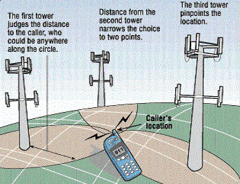
 Mobile Cell Triangulation

Roughly how it works....

Here is the video guide.


"Why the uncertainty? The My Location feature takes information broadcast from mobile towers near you to approximate your current location on the map - it's not GPS, but it comes pretty close (approximately 1000m close, on average). We're still in beta, but we're excited to launch this feature and are constantly working to improve our coverage and accuracy.

The My Location feature is available for most web-enabled mobile phones, including Java, BlackBerry, Windows Mobile, and Nokia/Symbian devices."


Yes, it can be disabled.

Source: http://searchengineland.com/071128-110000.php

Labels: , , , ,

28 August 2007

FoxyTag - Speed Camera Locations Map

FoxyTag - Speed Camera Locations Map

Links speed cameras to map locations to mobile device

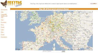
Speed Camera Locations Map

FoxyTag signals fixed and mobile speed cameras, data is updated every 5 minutes, the system works worldwide and is free.

Where does the data come from?
"FoxyTag is entirely collaborative (it is the users that post tags) and does not require any central operator to filter and validate data (it is done automatically). FoxyTag is a testing lab for future technologies and its main capital is its number of users."

more info

mapperz

Labels: , , , , , ,

09 April 2007

N95 Free Applications - including GPS & Maps

N95 Free Applications - including GPS & Maps

N95 in the Box
Source: Mapperz (this blog (via adsense) helped buy this device!))

To Start an Official Application (Supports Google Earth Output- KML)

Sports Tracker
"If you own a N95 one of the first things you should do is download the recently released free application 'Sports Tracker' from Nokia. Sports Tracker is aimed at the sports or general user on foot or cycling and more importantly it provides full route tracking with the ability to upload to Google Earth."
Source and More Info at Digital Urban

MapLoader and the Standard Software on the PC>Phone does the Job.
(though have a day to hand loading the maps on - 150mb took 6 hours)

Though recommend you only use this for Foot and Car Naviagation in Semi-Urban and Urban Areas. Or if you do hill walking, hiking and mountaineering this software is not for you.
The solution here would be to be able to import your own maps.

update:more free official apps here

Mobile GMaps
"Mobile GMaps is a FREE application that displays Google Maps, Yahoo! Maps, Windows Live Local (MSN Virtual Earth) and Ask.com Maps and satellite imagery on Java J2ME-enabled mobile phones, PDAs and other devices. MGMaps can connect to a GPS receiver over bluetooth or use internal GPS features on some phones in order to automatically display the map for your current position."
More Info and Download at mgmaps


Online Data Backup
All this Data but what if the phone goes down and and out have not backed up your phone?
"Store your mobiles phone numbers, calendar and SMS safely with ZYB. Sign up now, and get a copy of your precious mobile content"
https://zyb.com/

A Very Fast Calculator
Try this simple example: start the standard calculator and do 2/3 x 7. It takes 13 clicks. Using Calcium it only takes 6!
More Info
http://mtvoid.com/calcium/

Like to Stay in Contact?
Via Wifi or EGPRS*

http://mobile.live.com/wml/

http://mobile.yahoo.com/go


http://code.google.com/p/mobile-google-talk-http/

or use this app for all three
http://www.gizmoproject.com/
(Yahoo! Messenger, Google Talk, or Windows Live)

Free Phone Calls? (using Voice Over IP)
Using Wifi or EGPRS*
Fring

EGPRS* is charge by data transfer - depending on your network operator and mobile tariff this can vary in cost. Use Wifi if you can!
http://en.wikipedia.org/wiki/Enhanced_Data_Rates_for_GSM_Evolution
_Rates_for_GSM_Evolution

add a comment if you know of more!

mapperz

additions pending.... mapperz approval


Labels: , , , , , , ,