->

28 March 2011

Twitter Nano

Twitter Nano

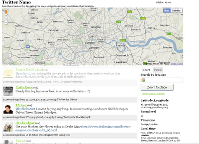
Search by Location (Cross-Hairs) and get real-time tweets from twitter.
Twitter Nano Map

A real-time geolocation Twitter experience Aim the crosshair by dragging the map and get realtime tweets from that location. It's that simple.

Twitter Nano
http://www.twitternano.com/

Source:
http://www.programmableweb.com/mashup/twitternano

Labels: , , , , ,

07 October 2010

Google Latitude Goes Desktop

Google Latitude Goes Desktop
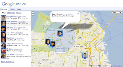
Google have launched Latitude with a desktop iGoogle gadget to help you stay in touch with friends and family that may not have a smartphone. Google learned that a desktop experience is important to you even if you’re already using Latitude on your phone. Today, you can now visit a dedicated site that makes it easier than ever to use Latitude when you’re already on your computer. From the Friends tab, you can:
  • See where your friends are on Google Maps
  • Add friends and accept sharing requests
  • Control your privacy settings

Google Latitude Goes Desktop

Do more with Latitude
You’ll also now find Latitude and Latitude apps together in one place. After browsing your friends list, go to the History or Apps tabs to turn on optional Latitude apps such as:
Google Latitude Apps (must be signed into Google)
https://www.google.com/latitude/apps

Labels: , , , ,

17 September 2010

Twitter: Tweet With Your Location

Twitter: Tweet With Your Location
(This additional service is now being rolled out across the world)

Twitter's Tweet With Your Location feature allows you to selectively add location information to your Tweets. This feature is off by default and you will need to opt-in to use it. You can find out how to start using this feature on the How to Tweet With Your Location help page; this article is an overview of the feature.Mapperz Twitter Tweet Location Map

Once you've opted-in, you will be able to add your location information to individual Tweets as you compose them on Twitter.com and with other applications or mobile devices that support this feature. The location information that is shared publicly can be either your exact location (your coordinates) or your place (like a neighborhood or town).

Tweeting with your place or coordinates can add context to your updates and help you join the local conversation, wherever you are.

Helpful links for Your Questions:

How do I tweet with my location?

http://support.twitter.com/articles/122236

http://support.twitter.com/articles/78525-about-the-tweet-with-your-location-feature


This service was first introduced in November 2009 [USA only] via the twitter api, now this is available in users settings (off by default).

Most likey because FaceBook Places has been rolled out globally too.
http://www.bbc.co.uk/news/technology-11342802

Labels: , , , , ,

20 August 2010

100 Million Google Mobile Map Users

100,000,000 Google Mobile Map Users

Almost five years ago, Google launched Google Maps for mobile to help you get where you needed to go from your phone instead of a paper map.

Today, more than 100 million people a month are now using Google Maps for mobile to get from point A to point B, find nearby places, and more.

Over the past 5 years, Google Maps for mobile has changed quite a bit they are adding more ways to help you explore the world around you. There is My Location, you can quickly find where you are on the map with or without GPS. You can put your friends on the map with Latitude. Navigation even turns your phone into a free internet-connected 'SatNav' with voice guidance and Street View imagery.

Google Maps Mobile History 5 Years
Google Maps Mobile - The 5 Year Journey of Advancing Map Updates.

Lately, has seen some changes especially focused on helping you find the right place at the right time. With recent additions such as Place Pages, you can now pick a nearby place by browsing information such as opening hours and review snippets for the places around you.
It’s easier than ever to find those places with Search by voice or the new Places icon on Android. With this latest Android version, happy to see that you’re now searching for places almost three times as often, doubling how many Place Pages are seen a day.

Source & Image:
http://googlemobile.blogspot.com/2010/08/to-100-million-and-beyond-with-google.html

Labels: , , , , ,

11 February 2009

Gmail gets location support

Gmail gets location support

Google Mail (Gmail) has now the ability via Google Mail Labs to add your location to your signature.
You have to enable experimental 'labs' (in gmail settings).

Gmail gets location support

Gmail signature location
Tick the 'Append your location' to activate the location factor.

Note: Google Gears (if installed) will ask for permissions to access your location (via ISP or Mobile/Cell network).

Gmail compose email signature with location

What No Map?
Request: A little Static Map that can be embedded into the email (if html)

like this:

Map Created with the Static Map Wizard

Source:
http://gmailblog.blogspot.com/2009/02/new-in-labs-add-your-location-to-your.html

Some other thoughts
http://searchengineland.com/gmail-labs-adds-location-to-signatures-16518
http://blogoscoped.com/archive/2009-02-11-n42.html

Labels: , , , , ,

25 September 2008

Map Channels Events - New!

Map Channels Events - New!

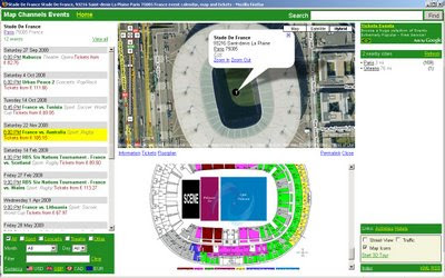
Map Channels Events - New
Find sporting events or concerts by location fast.

Map Channels is an exceptional website portal and provider of a range of free mapping tools and custom mapping services:

It has now expanded and now integrates events, mapping and ticket purchase in one website.

Map Channels Events Paris
Quickly locate events all over the world and select the event by map or city search, also different currencies are supported.

"A world of events at your fingertips"
• Interactive event calendars and venue maps
• Find events by name, category, date or location
• Ticket price comparison
• View city tours, attractions and activities
• Explore venues with Google Street View and Google Earth

Well done the Map Channels Team [again]
To see their progress visit http://mapchannels.com/News.aspx

Labels: , , , , ,

19 May 2008

Yahoo! Internet Location Platform (New Geocoder)

Yahoo! Internet Location Platform (New Geocoder) New!

"The Yahoo! Internet Location Platform provides a resource for managing all geo-permanent named places on Earth. The purpose in creating the Internet Location Platform is to provide the Yahoo! Geographic Developer Community with the vocabulary and grammar to describe the world's geography in an unequivocal, permanent, and language-neutral manner.

The Internet Location Platform is designed to facilitate spatial interoperability and geographic discovery; users can traverse the spatial hierarchy, identify the geography relevant to their users and their business, and in turn, unambiguously geotag, geotarget, and geolocate data across the Web."

Basically this is a Geocoder for Places across the World. The accuracy is fairly precise and the easy to understand.

Here is an example:
http://where.yahooapis.com/v1/places.q('10%20downing%20street%20london%20uk')

and also you can geocode UK Postcodes - full UK Postcodes!

http://where.yahooapis.com/v1/places.q('SW1A2AA')
*link fixed
Yahoo Where Geocoder
Centroid is the postcode centre. So 51.503201, -0.12617

Checking... on the map.
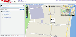
Yahoo Where Geocoder Map

http://developer.yahoo.com/geo/

Rate Limits
Currently, users of the Internet Location Platform are limited to 50k queries per day.

Terms of Use (Please check this if you intend using this service with other non Yahoo Applications)
http://info.yahoo.com/legal/us/yahoo/api/api-2140.html

Geeky Stuff

"In simple terms, the Service allows you to look up the unique identifier - called the Where on Earth ID, or WOEID - for almost any named place on the Earth; it also allows you to resolve a WOEID you have received from a third party - such as Fire Eagle™ or Upcoming - to the place it represents.

The API is accessed via HTTP GET; the following examples can be cut-and-paste into a web browser to view the results:"
http://developer.yahoo.com/geo/

Mapperz

Labels: , , , , , ,

25 April 2008

The Future of Mobile Mapping? (Location Based Services)

The Future of Mobile Mapping?

"location-based content in a unique way that bridges the gap between reality and classic map-like representations"


Enkin from Enkin on Vimeo.


Two Uber Mappy Geeks show you a glimpse of Mobile Mapping in the near future.

This is one for the Google Android Developer Challenge

Found via

http://blog.wired.com/sterling/2008/04/enkin-is-the-li.html

via http://www.thefutureisawesome.com/

via browsing

http://edparsons.com/

More info on Location Based Services (LBS)

http://en.wikipedia.org/wiki/Location-based_service

Labels: , , , , , ,

30 January 2008

Nokia Beta Labs - Location Tagger

Nokia Location Tagger
(georeferencing your phone camera photos)

Nokia Location Tagger

"What is it all about? Nokia Location Tagger is a small application running on “selected” S60 3rd devices that allows you to tag pictures captured from Camera application with geographical coordinates from GPS. The tagging process itself is sometimes called geotagging or geocoding (see also this article at Wikipedia). Technically, the location information is stored in the EXIF header of your pictures (.jpg file)."

Nokia Location Tagger S60


With Nokia Location Tagger, you can automatically tag your location data to your pictures. As you take a picture, your GPS coordinates are saved to the EXIF header of the JPEG file. You can use this data later, for example, to locate your pictures on a map.
In the near future, we hope to make location tagging a seamlessly integrated part of your Nokia experience. Until then, Nokia Location Tagger is a small standalone application that gives you a sneak preview. We are not planning to productize this application as such, but we’d love to hear your thoughts already now, so that we have time to take it into account in the mainstream development.
Tested with Nokia N95, N95 8GB, N82, and E90 using the integrated GPS. Should work but not fully tested with all S60 3rd edition devices using an external Bluetooth GPS receiver. Sharing your location-tagged pictures online requires Share Online 3.0.

- Launch Nokia Location Tagger application.- On the main screen, you will see the status of your GPS module. It will show the coordinate if GPS module is active. Otherwise, it will show "Searching".- To tag pictures with GPS coordinates, simply use the built-in Camera application. Press the Camera button of your device to take pictures as usual. When Nokia Location Tagger is running in the background, you will see small icon at the top left corner of Camera’s view finder. This indicates the status of GPS module: Green: GPS module is active. Amber: Nokia Location Tagger is connecting to GPS module or searching for GPS coordinate. Red: GPS module is inactive.

Q: What happens if I take pictures while the GPS module is not active yet?

A: Nokia Location Tagger tries to tag pictures to the last "known" coordinates in the last 10 minutes. Since GPS module normally takes some time to initialize, it’s better to launch Camera application a couple of seconds before taking pictures. Launching Camera application will activate Nokia Location Tagger; which will initialize GPS module. You can also bring Nokia Location Tagger window to the foreground to initialize GPS module.


Q: Will my battery be empty very fast when running Nokia Location Tagger in the background?A: Nokia Location Tagger has a time-out feature (by default, it is 5 minutes). If there is no picture until time-out time, the GPS module will be turned off. This will normally save power. you can change the time-out option in the settings (2, 5 (default), or 10 minutes)

Q: How can I view the GPS coordinates of my pictures?A: The GPS coordinates are stored in the EXIF header of JPEG files. Some online sites, such as Flickr and Panoramio are able to display GPS coordinate from the EXIF. For more info on these services, please see below. You can also use photo organized software that read EXIF, such as Picasa (with the combination of Google Earth).
Q: How can I set Flickr to automatically import location in my uploaded pictures, and place them on a map accordingly?A: Please go to this URL: http://www.flickr.com/account/geo/exif, sign in, tick the yes please box and click save. From now on, all new tagged pictures that you upload will automatically be placed on a map. Also underneath every picture, there will be a map link that - after you click on it - shows where the picture is taken. Here are some examples. A nice alternative to Flickr is Panoramio. After uploading your pictures, you can view them on Google Maps but also export them to Google Earth. Here are some examples.
issues- The pictures from secondary camera are not tagged. Nokia Location Tagger tags pictures from the main camera only.- In a very rare case, Nokia Location Tagger may not be able to tag picture with the error message "File is being used".- Pictures captured in burst mode may not be displayed in order in the Logs tab.- This version has been tested on N95, N82, E90 as well as N73, N81 with external GPS module (Nokia LD-4W). It should work on all other devices; but there is no guarantee at this point.

What can we do with the Geo-tagged pictures? You can upload them to the photo sharing sites, such as Flickr, Panoramio and Picasa Web, so that your friends know where the pictures were taken. If you want to keep them private on your PC, some photo organizer applications, such as Picasa (combined with Google Earth), are able to display location information.
Please read the instructions at Nokia Location Tagger web page.

Labels: , , , , , ,

27 June 2007

Sky News - UK Flooding Map (Pics)

Update - if your looking for UK Floods in Southern, West and Midlands [20th July to 24th July 2007]
Go to the newer page
http://mapperz.blogspot.com/2007/07/uk-flooding-links.html


Sky News UK Flooding Map showing pictures of the Flooding in the North of England - News has Location.


Sky News UK

More and more Maps are Illustrating news events - giving the users a sense of the scale of the matter.
(other parts of the UK have been affected - though the North of England has had it very bad.)

Source: Google Maps Mania via Press Gazette

More Flooding Pictures from the BBC Site

Labels: , , , , ,

30 March 2007

Find the Vine - Search by Grape or Wine

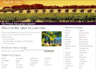
A nice website for all you wine connoisseurs (including mapgirl)

Find the wine map site
Search by Appellation d’origine contrôlée (AOC) or by grape.

Nice and clean website findthevine.com full of wines from France and a Google Map showing you the geographical locations where the grapes vines and wine production is.

Find the wine google map
Notice the Gpolygon from the Google Maps API is used on this site.

"I'd been wanting to learn more about French wine, so hit upon the idea of merging the legal texts about French A.O.C's from http://www.inao.gouv.fr/ with Google maps, to represent where different wines are grown.
Your post http://mapperz.blogspot.com/2007/01/google-maps-and-topology.html was very helpful in getting the GPolygon working in IE6."
Graham King - Google Map Maker and wine enthusiast (http://www.darkcoding.net/index.php)

mapperz reply - your very welcome.

Labels: , , , , ,

21 February 2007

Google Map Public Calendars

Google Maps Public Calendars

Google Maps Public Calendars
example
http://www.google.com/calendar/events?q=Marathon
&ql=London&qt=&qtd=&sa=N&page=vl&afp=393d85a865eecf88

A New Feature in Google Calender is to be able to search Public Calenders and Events

"Now you can search the web for events and add them directly to your Google Calendar. Within Google Calendar, type an event search into the search box like "Symphony in San Francisco" and click "Search Public Events". You'll see a list of events that you can easily add to your Google Calendar."

more new features
http://www.google.com/intl/en/googlecalendar/new.html

There is also a Google Calendar API

The Maps for calendar only work when the user has inputted the location of the event.
All Events should have a location, therefore should be mapped.

Source:Mapperz

Though please remember Google Calendar is still Beta.

Labels: , , , , ,

27 December 2006

Ask City Maps Supports Reverse Geocoding

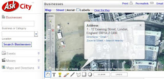
Using Ask City now supports reverse geocoding... and supports UK Addresses.

Clicking on the Map or Aerial Photo with the yellow icon will submit a request to find the address and returns the results in a ballon.

Ask Maps Reverse Address Geocoding Searching
Searching an Address

Ask Maps Reverse Address Geocoding Result
Result
Well done Ask

Labels: , , , , ,