->

13 October 2010

Travellerspoint.com

Travellerspoint.com helps you plot future and past trips on a map. Control trip colours, curves, transport modes.

"The goal of Travellerspoint is to create an international meeting point for travellers worldwide, whether they are planning their travels, currently travelling or have returned from their travels and want to stay in touch with (or find) those travel friends they met while travelling in the past."

TravellersPoint.com Map

http://www.travellerspoint.com/guide/

Labels: , , , , , ,

18 May 2010

10 Years of GPS: Where Next?
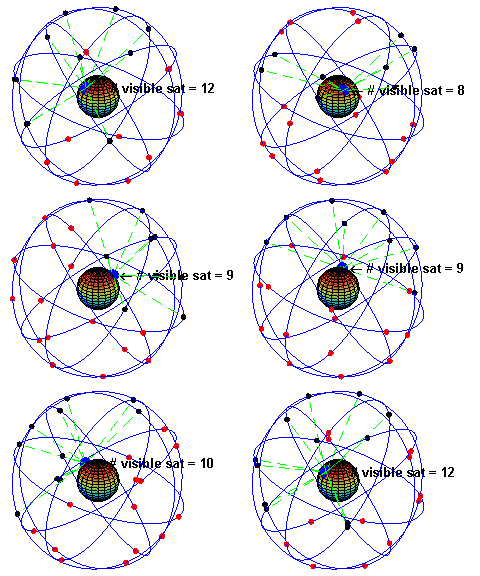
10 Years of GPS: Where Next?

Constellation GPS Satellites
In the 10 years since the USA military was ordered to unscramble the GPS signal, the big benefit has been to increase accuracy from about 20+m to less than a few metres.

"Global Positioning System (GPS) is a space-based global navigation satellite system that provides reliable location and time information in all weather and at all times and anywhere on or near the Earth where there is an unobstructed line of sight to four or more GPS satellites. It is maintained by the United States government and is freely accessible by anyone with a GPS receiver."

http://en.wikipedia.org/wiki/Global_Positioning_System

From SatNavs to Mobile phones GPS is integrating more and more into everyday lives. But will the car self drive you to the petrol station when the tank is almost empty? Will the bike tell you the nearest location to clean/fresh/tap water?

Using GPS in the future will be interesting gearlog says:
Predictive swiveling headlamps. "On higher-end cars, the headlamps swivel lift and right when you turn the wheel. With more accurate GPS, the car would start to turn the headlamps a second or two before the road curves. That adds a small measure of safety. Plus, on a dark country road at night, sometimes it's hard to recognize if you're seeing the road marking cuangled white rail fence 20 yards off the highway. The
headlamps could help show you the way."
http://www.gearlog.com/2010/05/10_years_of_unscrambled_gps_th.php#more

GPS handset for the visually impaired

"
The 3D map of the city is lifted up from the surface of the device and moves as you move, like a compass and with zoom, search, voice command, and everything. All in your palm. "
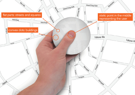
GPS handset for the visually impaired
http://www.yankodesign.com/2010/04/22/gps-in-a-hand-disk/

Tam Tam GPS Flashlight

Personal Navigation with the ability to project your own custom route on the pavement or wall in front of you.
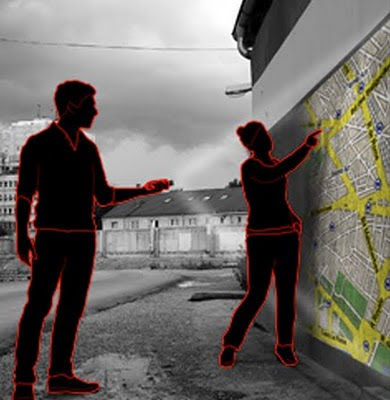
GPS projector map concept

http://www.gizmag.com/tamtam-gps-flashlight-concept/14284/

Or the Scout – Portable Pedestrian Navigation Device
Intended to be used by people traveling about, connecting then with local knowledge, wisdom, and GPS information to guide them. It’s a digital compass is what it is. It encourages “uninhibited exploration, discovery, documentation, and sharing.”
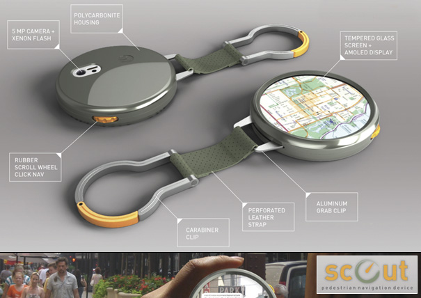
Pedestrian Navigation Device
http://www.yankodesign.com/images/design_news/2009/12/02/motobook01.jpg

How to power and maintain it all.
But the huge advances in powering and maintaining these devices (power cells, solar, wind charging etc) will help users no end with the previously frustrations of running out of power for the many devices that are out there to be consumed.

Labels: , , ,

02 November 2009

Weather.com goes into the 'Future' (Bing Maps)

Weather.com goes into the 'Future' (Bing Maps)

Weather.com Temperature Bing Future Map BetaWeather.com Cloud and Radar Bing Future Map Beta
The new 'Future' button starts moving into a predicted mode using 'trupoint' technology at 15 minute intervals up to 6 hours into the future.

http://www.weather.com/weather/map/interactive/30004?from=36hr_maps&zoom=8&interactiveMapLayer=radar


"The Weather Channel's unique TruPointSM technology delivers the most accurate weather reports and forecasts - for more locations - than any other weather provider.

NEW: TruPoint technology is now available on weather.com interactive maps! See exactly where storms are forecasted for up to the next six hours so you can better plan and prepare for any activity."


Summary of TruePoint Technology

  • A highly localized weather forecast; accurate down to a one-square mile area.
  • Allows you to zero in on specific places such as schools and parks.
  • Available every 15 minutes across a 6 hour period.
  • Available only within the 48 contiguous United States.
  • A proprietary technology developed and used exclusively by The Weather Channel.
  • Full details on the technology here:
    http://www.weather.com/encyclopedia/trupoint.html?from=hrly_trupointlogo

    source:
    http://www.bing.com/community/blogs/maps/archive/2009/11/01/weather-com-adds-futures-on-bing-maps.aspx

    Labels: , , , , , , ,

    24 August 2008

    The Future of Paper Maps? Here Now?

    The Future of Paper Maps? Here Now?

    The video shows different content (layers/scale) of the map when the angle of paper map is adjusted.


    Will 21st technology save the decline in paper maps? [A Techcrunch Video]

    Users of new mobile phones are likely to have the technology (GPS-A-GPS), but do they know how or want to use it? The paper map is always a saver when the battery is dead or the internet has returned an error.

    "The three Images are interlaced by alternating horizontal strips from each. The resulting compound image is calibrated to a specially designed polymer lens substrate. Lenses contain between 60 to 200 micro-lenses per inch, depending on the desired outcome. This is mounted to a backing, die cut and packaged"

    The 'MapAction' Technology is described here:
    Source:
    http://panamap.com/mapaction-technology/index.html

    Source:
    http://www.gadling.com/2008/08/23/
    urban-mapping-cleates-multi-vision-foldable-maps/

    Labels: , , , , ,

    25 April 2008

    The Future of Mobile Mapping? (Location Based Services)

    The Future of Mobile Mapping?

    "location-based content in a unique way that bridges the gap between reality and classic map-like representations"


    Enkin from Enkin on Vimeo.


    Two Uber Mappy Geeks show you a glimpse of Mobile Mapping in the near future.

    This is one for the Google Android Developer Challenge

    Found via

    http://blog.wired.com/sterling/2008/04/enkin-is-the-li.html

    via http://www.thefutureisawesome.com/

    via browsing

    http://edparsons.com/

    More info on Location Based Services (LBS)

    http://en.wikipedia.org/wiki/Location-based_service

    Labels: , , , , , ,

    31 March 2008

    3D Geology Maps

    3D Geology Maps using Virtual Earth


    Geology Maps Available (US only)

    Arizona Grand Canyon NP

    Colorado (western half)

    Utah (state level)

    Washington State (state level)

    http://www.3dgeomaps.com/ (3D-plugin required to view in 3D)

    Future of Virtual Earth?

    There is some impressive functions and new features coming to Virtual Earth very soon.

    Microsoft is storing 15 PetaBytes of data that is used with Virtual Earth. (a lot)
    The next VE release is April (due 10th April 2008)

    • "Enhanced experiences with bird's eye view in 3D, and new bird's eye hybrid view..."
    • Reverse geocoding for U.S. users.
    • Walking directions for North America and European Union users.
    • Traffic-based driving directions.
    • New cross-browser support.
    • Improved printing support for maps.

    Sources:

    http://www.nateirwin.net/VirtualEarth61BringsMoreFeatures.aspx

    http://www.liveside.net/blogs/main/archive/2008/03/19/virtual-earth-at-mix08-with-silverlight-and-seadragon.aspx

    Compatiablity with Virtual Earth + Silverlight
    Virtual Earth + Silverlight + Seadragon
    MS VE Silverlight 2.0 Beta SDK coming soon

    Labels: , , , , , ,

    04 December 2006

    The Possible Future of Web Mapping

    An Interesting Article
    http://datamining.typepad.com/data_mining/

    Get Mapping Terrain
    Nearly as if being there yourself...

    GetMapping

    Labels: , ,
