->

18 May 2010

10 Years of GPS: Where Next?

10 Years of GPS: Where Next?

Constellation GPS Satellites
In the 10 years since the USA military was ordered to unscramble the GPS signal, the big benefit has been to increase accuracy from about 20+m to less than a few metres.

"Global Positioning System (GPS) is a space-based global navigation satellite system that provides reliable location and time information in all weather and at all times and anywhere on or near the Earth where there is an unobstructed line of sight to four or more GPS satellites. It is maintained by the United States government and is freely accessible by anyone with a GPS receiver."

http://en.wikipedia.org/wiki/Global_Positioning_System

From SatNavs to Mobile phones GPS is integrating more and more into everyday lives. But will the car self drive you to the petrol station when the tank is almost empty? Will the bike tell you the nearest location to clean/fresh/tap water?

Using GPS in the future will be interesting gearlog says:
Predictive swiveling headlamps. "On higher-end cars, the headlamps swivel lift and right when you turn the wheel. With more accurate GPS, the car would start to turn the headlamps a second or two before the road curves. That adds a small measure of safety. Plus, on a dark country road at night, sometimes it's hard to recognize if you're seeing the road marking cuangled white rail fence 20 yards off the highway. The
headlamps could help show you the way."
http://www.gearlog.com/2010/05/10_years_of_unscrambled_gps_th.php#more

GPS handset for the visually impaired

"
The 3D map of the city is lifted up from the surface of the device and moves as you move, like a compass and with zoom, search, voice command, and everything. All in your palm. "
GPS handset for the visually impaired
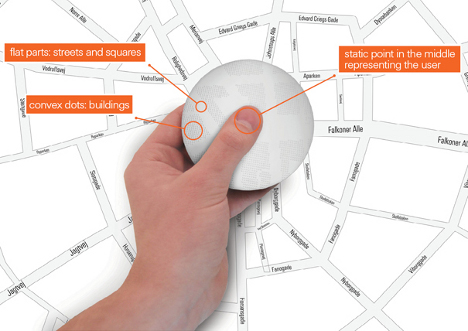
http://www.yankodesign.com/2010/04/22/gps-in-a-hand-disk/

Tam Tam GPS Flashlight

Personal Navigation with the ability to project your own custom route on the pavement or wall in front of you.
GPS projector map concept

http://www.gizmag.com/tamtam-gps-flashlight-concept/14284/

Or the Scout – Portable Pedestrian Navigation Device
Intended to be used by people traveling about, connecting then with local knowledge, wisdom, and GPS information to guide them. It’s a digital compass is what it is. It encourages “uninhibited exploration, discovery, documentation, and sharing.”
Pedestrian Navigation Device
http://www.yankodesign.com/images/design_news/2009/12/02/motobook01.jpg

How to power and maintain it all.
But the huge advances in powering and maintaining these devices (power cells, solar, wind charging etc) will help users no end with the previously frustrations of running out of power for the many devices that are out there to be consumed.

Labels: , , ,

30 November 2009

OpenSteetMap Potlatch 2 Development Preview

OpenSteetMap Potlatch 2 Development Preview
"It's not just an online map editor - it's a Live Cartographic Online Editor"
Potlach 2 Editor

OpenStreetMap users are getting a brand new online 'cartographic' editor in the form of Potlatch TWO (2.0)
Potlatch 2 is a complete rewrite.

Aim:

  • Speed

  • Ease-of-use

  • Flexibility

Four big new features :

1.New feature – friendly tagging system Potlatch 2 has a friendly, intuitive tagging system. The mapper can use graphical menus, dedicated fields, and icons to get the tagging just right – without the need to remember tag names and values.

Graphical Presets - no need to lookup or remember tags

Potlach 2 has a friendly, intuitive tagging system. The mapper can use graphical menus, dedicated fields, and icons to get the tagging just right – without the need to remember tag names and values.

2.New feature – 'What You See Is What You Get' (WYSIWYG) rendering Potlatch 2 has an all-new rendering engine far in advance of the current one.


Potlach 2 Editor MapCSS


source:http://www.opengeodata.org/2009/11/30/introducing-a-new-osm-editor-potlatch-2/
With road names, patterned fills, rotated icons, and much more,form a Cartographic editing experience can be like working live on the familiar Mapnik rendering, the cyclemap, Osmarender, or anything you like -making it much more approachable for the beginner.Thumbs ups for this!

3.Cascading Style Sheets - CSS but for Maps = MapCSS


Just like the tagging, the rendering is easy to customise. It uses a special form of CSS, called MapCSS, which lets you create wonderful-looking maps with just a few lines of text. The tagging and rendering together make Potlatch 2 ideal for ‘vertical’ mapping applications, such as a cycle-specific editor or a building/addressing editor. Stylesheets aren’t just about making the map look pretty: you can create stylesheets to help your mapping, such as one that highlights roads without names.
So if your only interested in Footpaths then only show footpaths


Because this integrates fully with MapCSS stylesheets, you can choose to temporarily hide background data, or show (say) only footpaths… whatever you like.

So Potlatch 2 will have an accompanying ‘OSM Guide’, explaining the basics with friendly, illustrated text. It will be concise, focused and clear.

4.New feature – vector background layer Mappers are working more and more with imports. But the approach until now has been to import data directly into the map – and many people have pointed out the problems this can lead to.Highly requested


Potlatch 2 will support vector background layers.

You can load OSM-formatted data from servers or files, and work on bringing it into the map the way you want, at your own pace.
Fully rewritten in ActionScript 3 Potlatch 2 is written in ActionScript 3, a Java-like language with an open source compiler and full docs available online. The Potlatch 2 source comes with instructions on getting started and is, of course, permissively licensed under the WTFPL.
Potlatch 2 thus far has been written by Dave Stubbs and Richard Fairhurst (Great Work). But we would love to see more people hacking on the source. There’s a potlatch-dev mailing list especially for this.

New Existing Features likely to be coming:
Some other features, like Yahoo and tiled backgrounds, are finished but not currently exposed through the editor: they’ll be along shortly. Others, such as GPS track support, the Beginners’ Guide and the vector background layer are not coded yet but are intended for the initial release.Load Import Shapefile? Export Shapefile options?? Would be good. [Hint]


Potlatch 1 has some three years of development behind it, of course, and much of this feature set has not yet been ported to Potlatch 2. There’ll be countless little UI tweaks (no keyboard shortcuts yet, for example!); and as you’d expect for an in-development version, performance can sometimes be sluggish and there’s a lot of optimisations we’d like to do.
But with work progressing so fast, this seemed a great time to talk about it. Both the tagging system and the renderer are enormously flexible and we’d like to see people hacking on them as soon as possible.
Live Version
at:http://www.geowiki.com/potlatch2/
Renderer alone at:
http://www.geowiki.com/halcyon/

Should you want to try a particular area, just put the lat and lon in the URL like this:


http://www.geowiki.com/potlatch2/?lat=52.2&lon=0.1http://www.geowiki.com/halcyon/?lat=52.2&lon=0.1

Source Code is at:http://trac.openstreetmap.org/browser/applications/editors/potlatch2

More on MapCSS and documentation at:http://wiki.openstreetmap.org/wiki/MapCSS

Full Credit and Original Post
http://www.opengeodata.org/2009/11/30/introducing-a-new-osm-editor-potlatch-2/

Labels: , , , , , , ,

17 July 2009

Open Street Map - Static API (Development)

Open Street Map - Static API (Early Development)

"Main idea of the project is to create an web application which will provide an easy way of embedding maps into web pages. Application is going to be deeply configurable and easy to install by anyone on his server. It is being implemented in PHP5.

Mapperz first static osm map:

This an Open Street Map generated image live from the osm development server
The url that created this image is
http://dev.openstreetmap.org/~pafciu17/?module=map&center=-1.877589,50.7224&zoom=14&width=400&height=400type=cycle

Required parameters:

&center=latitude,longitude
&zoom=14 (can be 1 to 18)
&width=400 (400px)
&height=400 (400px)
type=cycle (can be mapnik, osmrender or cycle)

optional &imgType=gif or jpg (png is default)

Paths can be created (Google Maps API static maps lacks this function currently)


http://dev.openstreetmap.org/~pafciu17/?module=map&bbox=-100,45,-67,5&width=400&paths=-74,40.34,-82.3,23.1,-85,35,-87.2,32.12;-90,40,-80,40

(green is the first zigzag lines then after the semi-colon ; is the second line)


Suggestions and reporting errors:
During first month of work scaffold of application has been created with its basic functionality. Now it is time for improvements and adding new features. I would be very grateful for any feedback about API. You can send comments, information about errors etc. to osm.static.maps.api(at)gmail.com."

Mapperz has a couple of suggestions:
Can annotation be added? Like "you are here" anno=you%20are%20here;-90,180
Can polygons be added? poly=-90,180;-80,180;-80,90;-90,180&fillcolour=R255G123B0
icons - icon=basic1&3 (a circle with 3 in the middle)?

Full details
http://dev.openstreetmap.org/~pafciu17/


Your area missing map data?
Then contribute to the Open Street Map database - you be surprised how easy it is to add your own collected data. You might even get hooked like with 125,000 other osm contributors.
http://wiki.openstreetmap.org/wiki/Main_Page

Looks very promising.

Labels: , , , , , ,

10 January 2008

New Nuclear Plants Get Go-ahead - KML Map

New nuclear plants get go-ahead
from the BBC News Top Story
http://news.bbc.co.uk/1/hi/uk_politics/7179579.stm

Nuclear UK Development Plans
Image Source: BBC News/Jackson Consulting & DTi


To Location Map in Google Maps with link to the Wikipedia for each site.


View Larger Map

Thanks to Mike Williams (HTML in KML assistance)

Labels: , , , , ,

06 August 2007

Major Infrastructure Development Map

Major Infrastructure Developments Map (UK)

The Map that shows the location of proposed major infrastructure developments (such as airports, tidal barrages, and nuclear power sites) that may be built following a proposed change to UK planning law.

"Good planning is essential for sustainable development and environmental protection. A coalition of the UK 's main environmental, conservation and civic organisations with currently over 5 million members came together out of a deep concern over many of the recommendations of the Barker Review of Land Use Planning. Having now been incorporated into the Government’s Planning White Paper, these recommendations would - if implemented in its current form - be a backwards step for the planning system"

Planning Disaster Map UK
Nice and clear icons show the user exactly what is going where.
Click on the icons to reveal more information about the planned development/re-development of sites.
See the Map

Other parties involved

Campaign to Protect Rural England Friends of the Earth The Wildlife Trusts The Ramblers RSPB Transport 2000 New Economics Foundation The Woodland Trust

Labels: , , , ,