->

29 April 2010

Ordnance Survey Maps Vector Map District Available

Ordnance Survey Maps Vector Map District Available


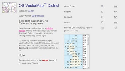
Finally a very useful dataset from ordnance survey for users wanting to create cartographic maps at mid-scale. Licence favourable for the use (with source attrbution) for the like of open street maps and others.

Techie spec.
Specification OS VectorMap District
CoverageGreat Britain ( England, Scotland and Wales )
Data sourceMajority of content derived from the mid-scales database. Buildings, cartographic text and functional sites derived from large-scale database.
Data structureESRI® Shape
ScaleNominal scale is 1:25 000.
Recommended scale range is 1:15 000 to 1:35 000.
Storage (unzipped)Tiles range between 6 - 20 Mb
Vector stylingShape format is supplied without styling, enabling users to customise the data to suit their needs.
Product content

Each vector feature has its own feature code, and falls within one of 15 layers:

A full list of feature codes and layers can be found here.

Number of tiles2860 tiles cover Great Britain
Tile size10km x 10km
Coordinate reference systemOSGB36. (@mapperz will have a WGS84 version by May2010)

Data Available to Download Here:
https://www.ordnancesurvey.co.uk/opendatadownload/products.html

Labels: , , , ,

23 December 2009

'Ordnance Survey Free' 23rd December 2009

'Ordnance Survey Free' 23rd December 2009

The document that everyone has been waiting for ;

"Policy options for geographic information from Ordnance Survey Consultation"
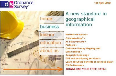
Ordnance Survey Website April 2010
Will the Ordnance Survey Website have a direct link to your free data in April 2010?

Ordnance Survey Free products from 1 April 2010 is shown below. It includes digital reference
products and digital display products:

Raster Free Products:
Vector
  • Code-Point - that's full grid refrenced postcode data
  • Boundary-Line - a specialist 1:10 000 scale boundaries dataset
  • Meridian 2 - transport network and topographic themes
  • Strategi - 1:250 000 scale topographic database

The products that are released as part of Ordnance Survey Free will continue to be
maintained by Ordnance Survey to a high and consistent standard. The product set
may evolve over time.

Ordnance Survey Free is intended to allow communities to combine (or “mash-up”)
government data about their community and environment from a number of sources
and illustrate their findings in a geographic context:

The raster products will enable developers to produce an application that overlays
their information on a map and to zoom-in from a national view with MiniScale
down to the street level with OS Street Viev, the gazetteer, boundary and postcode information will enable widespread use.

These commonly used geographies and it will act as a link between other
government data sets which reference the same geography
the 1:50 000 Scale Gazetteer provides a definitive source of town and place.

names to search and locate a place of interest on the map

Code-Point provides the location of every postcode to enable accurate search and display of specific locations and it will link to other data with a postcode reference

• Boundary-Line provides the outline and a unique reference to all the
administrative and electoral units of Great Britain.

• Meridian2 and Strategi are small scale vector products which provide the
geometry of features to allow customisation and combination with other data.
Meridian 2 includes a full named and attributed road network.

Issues - none is there?

Issues highlighted by Ordnance Survey:
The most immediate impact on Ordnance Survey as a result of the release of
Ordnance Survey Free products will be the reduction in revenues.
Three different types of existing and future revenue loss have been identified, and their potential impact on Ordnance Survey quantified.
These include: direct revenue impacts as a result of the loss of revenue from the products to be released for free; product substitution affecting Ordnance Survey’s remaining products, which will arise as customers switch to Ordnance Survey Free products; and increased competition impacts as competitors are able to derive their own products from the Ordnance
Survey Free products.

The estimated that the revenue loss to Ordnance Survey from a combination of
these three effects would be £19-24m p.a. Further growth was anticipated in these
products, which could now be foregone.

The provision of Ordnance Survey Free datasets and associated services has been
assessed on the basis of avoidable cash costs at £6-8m p.a. over the next five years,
including both the operating costs and on-going investments required for these
products. In addition there would be one-off development costs for data provision of
up to £1.1m.

source:
http://www.communities.gov.uk/documents/corporate/pdf/1415413.pdf [PDF]
[Section 7]

Labels: , , , , ,

09 September 2009

New Canadian Toporama WMS service - Examples

New Canadian Toporama WMS service - Examples

update:12/09/2009

Geospatial provides a little more information on ftp access {bulk downloads} to map data.
http://geospatial.blogs.com/geospatial/2009/09/nrcan-wms-service-for-canadian-vector-topo-maps.html


new link:
http://tinyurl.com/nuseox
(newer code)

WMS [Web Mapping Service]
is not new - in GIS and Technology terms is old.
But there are plenty of services, organisations, governments out there that do serve their content via this format.

So why this post - Well there was a Google Maps API Thread that was becoming very interesting:
"mentionned last week that canadian topo maps (NRCAN) are of poor quality. This is true. But a new service have been implemented in may by NRCAN to replace it. It seems this introduction passed unnoticed so far. I myself searched for a long time and to find information about this new service. NRCAN has introduced in may the Toporama WMS service. This gives access to the new CANTOPO, the new generation of Topographic Maps (1 :50,000) produced by NRCAN. Theses maps are in vector format. The availability of this new vector format for canadian topo maps gives us more precision and clarity as compared to the old Raster Maps format who where a scan of the Paper Maps. Texts describing rivers and local points of interest do not anymore collapse when zooming to lower levels. The map is also of higher quality at higher zoom level. And
the information shown on the maps is adapted to the zoom levels. "
PierreB

Then the talented google map api programmer PapaBear picked up on this and quickly developed this:
Canada Vector WMS Maps - Service - Google Map Mashup
the new generation of Topographic Maps from CANTOPO
The quality and content from this dataset is rich in detail, contours, very small lakes, buildings, rail road etc

Though the full credit goes to PapaBear for the example and PierreB for thier knowledge and skills to put this together in a very short space of time.

"This map is of a station (survey marker) very near the border in
Maine. It should open with USGS topo map type. These topos usually
overlap the border and show a short distance into Canada (usually to
the next 7.5 or 15 minutes of longitide, depending on the scale).

The map type is changed with the selector in the upper right. I have
kept the old raster version from NR canada (type "CanRas") as well as
the new vector maps (type "CanVec").

You can compare the USGS topos and the 2 Canadian types for the same
locale. The USGS map tiles are also raster data (and these have been
know to have missing areas and occasional mis-registration) but they
are higher resolution scans than the old NR Canada tiles..

The topography is not too interesting, since it's a swampy area, but
nevertheless the different map type are all visible. "

If you want to see a working example then go to:
http://members.bellatlantic.net/~vze2h6gy/papabear/BM_Station_GMap.html#FILE=Maine_Peaks.js&index=QF1769&title=1&width=960&height=720&showrm=1

{note: this is a testing environment and change be moved or changed without notice}

But hopefully users will be impressed with the resources and hopefully make use of the wms services still out there.

Well done.

Labels: , , , , , , ,

18 August 2009

Google Maps News - Street View & Map Maker

Google Maps News - Street View & Map Maker

update:19/09/09
Mexico is now available for Map Maker - please see the official blog post
http://google-latlong.blogspot.com/2009/08/map-maker-goes-west.html

StreetView has been expanded again this now covers
Switzerland and Portugal and also Taipei City in Taiwan

New Street View Chapel Bridge, Lucerne
Chapel Bridge, Lucerne with new Streetview coverage.

Google Maps Mania does a very good round-up of the coverage included
http://googlemapsmania.blogspot.com/2009/08/street-view-arrives-in-switzerland.html


Google Map Maker has been opened up some more with download-able vector data available for Africa [Terms of Use Apply]. This is either in KML format or Shapefile.

On the Mapmaker creation side Eastern Europe has now been opened up for editing.
This includes Albania, Belarus, Kosovo, Macedonia, Moldova, Montenegro, Romania and Serbia.
More news on this here
http://google-latlong.blogspot.com/2009/08/map-maker-gets-european-flair.html

Map Maker Africa Download
This data can be obtained by accepting the terms of use at this link
https://services.google.com/fb/forms/mapmakerdatadownload/
This data can be used in a GIS or Google Earth Application.

Labels: , , , , , , , ,

09 July 2009

Ericsson Web & Mobile Maps API (Labs)

Ericsson Web & Mobile Maps API (Labs)

Use Web Maps to embed powerful and flexible maps into your web applications.

  • Powerful map component easily embeded into any web page
  • Custom layers with your own objects and symbols
  • Embedded Java Applet with dynamic map rendering in the browser
  • Easily integrated Javascript interface
  • Automatic fall back to Javascript only version for browsers that doesn’t support Java Applets
  • Free access to map data (TeleAtlas - Vector data)

Ericsson Web Maps - Java

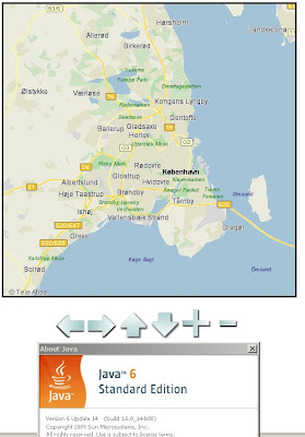
The Ericsson Web Maps API (Labs) uses Java for the mapping (javascript- fallback if no java available), first load can be a little slow at times.

Working Example

http://saudi.betainnovation.com/controls.html

Web Maps provide dynamic maps which you can integrate into any web application and features a large variety of control possibilities and overlay of symbols. The maps are rendered in a Java Applet which provides fast map browsing and smooth and animated interaction.

The dynamic rendering also let’s you control the look and feel of the map and how your users interact with it.

Currently limited in Mapping Examples. Users would be encouraged to create their own.

More information on the Web Maps API:

https://labs.ericsson.com/apis/web-maps/documentation

Mobile Version (also with an API)

"Mobile Maps is Java based and available both for Java ME and for Android. You download the Java ME or Android library, which provide the functionality of downloading, displaying, and interacting with maps to your applications. It also includes access to the map data itself."

Key Point with the Mobile Maps Version is:
"Through its unique functionality of rendering the maps in the mobile phone application Mobile Maps use very low bandwidth in comparison to many other map services and applications."

Mobile Maps is powered by Idevio and Tele Atlas


More information
https://labs.ericsson.com/apis/mobile-maps/

Source: (Also mentions the new SMS Send & Receive API)
http://blog.programmableweb.com/2009/07/04/5-new-apis-sprint-ericsson-and-volunteerism/

Labels: , , , , , , , ,

02 April 2009

Google Maps Map Maker [Vector Data]

Google Maps Map Maker [Vector Data]

update: more screen shots and discussion on Map Maker vs OpenStreetMap data
http://brainoff.com/weblog/2009/04/01/1391

***FOR NON COMMERCIAL USE***

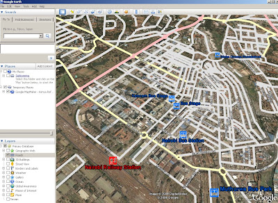
Google are now allowing you to download the vector data (Kenya only so far) in either Keyhole Markup Language (KML) or in ESRI Shapefile format.

Google are now returning the favour of Map Makers who have contributed to Google Map Maker

The idea of Google using users to map areas of the World where the likes of TeleAtlas Data is limited or non existent has been rewarding to both Google (gaining mapping content) and NOW non-commercial-non-profit entities.


View Larger Map
Google Map Maker- Kenya Vector in ArcMap
Screenshot of the Vector Data in ArcMap - Same data as above just different style applied.

View this as a layered/attributed PDF [will request to download or view] -1mb

***FOR NON COMMERCIAL USE***

Mapperz had a speedy look at this.

and loaded the shapefiles into a Geodatabase (topology can be cleaned and edited in ArcMap).

Created a quick Cartographic Representation and did a very quick style.

The Result is quite different to the Google Maps Style of Mapping (on purpose). But the underlining data is the same.
(no editing was done to the downloaded data - only shapefile to file geodatabase was done.)

Future: Does this step on the toes to projects like OSM? yes and no - can see both working.
Analysis -
There are many aspects of this vector data that can be applied - buffering, spatial searches and geocoding for starters...

Google Map Maker Kenya Vector Data Styled reloaded into Google Earth
The Exported 'Styled' Data from ArcMap (MapDoc to KML export) in Google Earth
Note: There are better KML/KMZ exporters than the standard ArcMap one

http://mapperz.kml.googlepages.com/Google_MapMaker_Vector_Kenya.kmz

(best loaded into Google Earth - file too big for Google Maps/API)

The Data is available after accepting the terms here
https://services.google.com/fb/forms/mapmakerdatadownload/

Thanks to Mano Marks via Twitter

Mapperz

Labels: , , , , ,

27 February 2009

Vector Magic - Raster to Vector - update

Vector Magic - Raster to Vector - update

"One of the best products out there that really does vectorize raster images to enable editing/scaling and just makes life easier in the cartographic world."


Vector Magic takes a raster image and recreates it in a vector format.
image sources: Vector Magic


The new version (26th Feb '09) v1.11 (pc) v1.14(mac) has a number of new features including:
  • Now export to AI (Adobe Illustrator), DXF (CAD) (in addition to EPS, SVG, and PDF)
  • On PC, export to Microsoft Office EMF format
  • More export options (group by colour, stroking mode)
  • More compatible EPS output
Get an order in by 6th March for the Desktop Version using the promotion code VMDE0306 before March 6th and get a $50 discount.

Mapperz has seen Vector Magic develop from Stanford University Artificial Intelligence research project into a fully commercial and viable product in less than 2 years. Well done to the creators in making and continuing to develop this excellent product.

Desktop Version
http://vectormagic.com/desktop/

Online Version Available (less functionality)
http://vectormagic.com/online/how_it_works

Source:
http://vectormagic.com/blog/posts


Labels: , , , ,

11 March 2008

Deep Zoom - Sliverlight 2 Beta

Deep Zoom - Sliverlight 2 Beta
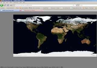
Deep Zoom Sliverlight Map
Deep Zoom requires silverlight 2 beta 1, works in firefox 3beta3.


This has potential - this is only one single image (4.1mb) but if you used quadtiles then the quality of the image when zooming would be preserved - this requires pre-processing and can be time consuming when dealing with high resolution images.
A Free Application 'MapCruncher' will produce tiles that can be used.
The extra item here is that you are not restricted to using raster data.
Vector Data can also be used.

Sliverlight highlights:

  • Custom branded experiences using 2D vector graphics, animation, styling, and skinning.
  • Highly sophisticated across major browsers on Mac, Windows, Linux, and devices.
  • HD video and adaptive streaming techniques for world-class media experiences.
  • Unparalleled interactivity with high resolution content through Deep Zoom technology enabling smooth browsing independent of screen size.

To Create 'Vector Tiles' there is a little known set of python scripts available here
http://research.microsoft.com/MapCruncher/TiledVectors/TiledVectorsDemo-1.1/description.html

There is a demo that works straight from the download (USA States)

In Virtual Earth
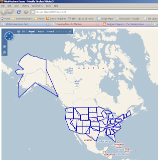
Tiled Vectors_Virtual Earth 2D
Very Generalised when zoomed out.

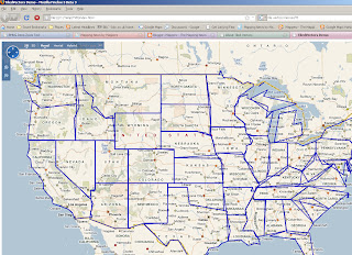
Tiled Vectors Virtual Earth 2D zoom

A Very Generalised Dataset but when you zoom in is much faster at displaying. Notice the less generalised data when zoomed in (this demo is purely to show the process).
When in 3D mode the Vector lines are rasterised on the fly.

Limitations - Polylines only - Polygon generalisation can be more demanding.

Combined the Four Products (Sliverlight, MapCruncher, TileVectors and Virtual Earth) and you have a nice production line for creating your own online/offline interactive maps.

Labels: , , , , , , ,

04 March 2007

Ordnance Survey New Product - Sitemap™

Ordnance Survey Releases A New Product - Sitemap™

Ordnance Survey Sitemap™
Image Source: Ordnance Survey

"OS Sitemap provides customers with extracts of Ordnance Survey mapping in a number of different formats and to different scales. It is has been developed to suit the requirements of a broad range of customers - from private individuals requiring a paper map to large design and engineering organisations wanting map data to be used within a computer system."

OS Sitemap provides a detailed and seamless view of topography of Great Britain:
Three scales
  • 1:1250 (Derived from OS Master Map)
  • 1:2500 (Derived from OS Master Map)
  • 1:10 000

Available in Paper (Colour or Black and White)
Raster Images (LZW compressed Tiff or PDF format)
Vector (DXF but not NTF or GML)

But is it cheap?
No, cheaper than OS Master Map but for Personal use and even small businesses it is expensive. Use Open Street Map (free) as an alternative instead.

Prices, the PDF just points to Sitemap at the end available at Ordnance Survey Mapping and Data Centres, it depends on a number of factors

Raster or Vector formats
Colour or Black and White
Size of Area needed
and complex pricing structuring dependant on your use, commercial vector on a website will lead to many ££££.

To find your nearest stockist

60 Layers of Features however here are some that are Not included are

Roads under 100 metres (Private Land)
Rights of Way
Detail under bridges (so captured from aerial photography and not surveyed?)
Detail under elevated roads
Buildings below a minimum size (resolution of image not high enough to capture it?)
Land parcel areas and House Numbers

Good for Ordnance Survey to create new digital products, however they need to make purchasing and costs more accessible to the public.
If they reduce prices they would gain more customers and not scare many off with complex pricing, are all 47% of Ordnance Survey is paid by the tax payer.
so do UK tax payers with get a 47% discount with that?

mapperz
likes OS products and uses them most days in a commercial sense, though OS need to make it easier and cheaper for Joe Public to use it for personal use.

Labels: , , , , , , , , ,