->

11 August 2011

USGS Historical Map Release

USGS Historical Map Release (Coming Soon)

The USGS Historical Quadrangle Scanning Project (HQSP) is scanning all scales and all editions of approximately 250,000 topographic maps published by the U.S. Geological Survey (USGS) since the inception of the topographic mapping program in 1884.

USGS Map Locator
National Map Viewer can locate historical Maps for user to download

Because historical maps are stored in a limited number of collections and are not readily available, the USGS National Geospatial Program has begun a project to convert these historical printed topographic quadrangles to an electronic format (GeoTIFF and GeoPDF®). This project serves the dual purpose of creating a master catalog and digital archive copies of the irreplaceable collection of topographic maps in the USGS Reston Map Library as well as making the maps available for viewing and downloading from theUSGS Store and The National Map Viewer.
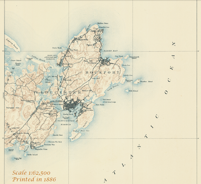
USGS Map 1886
One of the first Maps Created by USGS back in1886 will be available to download.

Source:
http://dracutlibrary.wordpress.com/2011/08/11/historical-maps/

Official PDF on the project
http://pubs.usgs.gov/fs/2011/3009/fs20113009_013111.pdf [PDF]

Link to the National Map Viewer [USGS Store]
http://store.usgs.gov/b2c_usgs/usgs/maplocator/%28ctype=areaDetails&xcm=r3standardpitrex_prd&carea=%24ROOT&layout=6_1_61_48&uiarea=2%29/.do

*Some maps will require a purchase - but most will be free of charge to download in GeoPDF and GeoTiff formats.


Labels: , , , , ,

12 August 2010

Sports Tracker 3.5 Released

Sports Tracker 3.5 Released

Sports Tracker
The Award winning FREE Sports Tracker Application gets an update along with revamped web service for viewing and sharing your routes.

"The newly launched online service allows users to store, visualize and analyze their workouts with enhanced tools, as well as share their media enhanced workout experiences with other Sports Tracker users - and the whole world. The online service also allows existing Nokia Sports Tracker Beta users to import their workout history to the new service.

The Sports Tracker mobile application has also been updated to support uploading of tracked data to the new service and direct sharing to Facebook. The update also extends the list of compatible devices to cover more than 50 device models."

Testing the New Sports Tracker:
Sports Tracker 3.50 Mapping GPS Routes
Mapperz has tested this and the services along with the phone application works seamlessly together.

With the FREE Sports Tracker application mobile phone becomes a full-featured GPS sports computer, keeping track of everything from calories burned while running to your average cycling speed over altitude. You get maps, time and distance calculators, step count, and even heart rate when you use a compatible Polar HR belt. You can chart your progress, find your strengths and weaknesses, and share with others.

The new mobile application allows users to:
  • Record activities with all the data needed to analyze the performance, including distance, speed, duration, route, step count and more.
  • Check their location on the map while running, cycling, walking or with any other outdoor activity, using Open Street Map as a map based (can be cached for offline use)
  • Upload their activity data from their phone to the Sports Tracker service
  • Share their activities and automatically geo-tagged photos with other users and friends on Facebook, directly from their phone
  • Optional with Heart Monitor - Record heart rate data by connecting the Polar WearLink®+ transmitter with Bluetooth® heart rate belt by Polar (€70 or $90USD)
  • Automatically compare speed, distance and duration of recorded activities


Get it here:
http://www.sports-tracker.com/

With this Launch Ovi (Nokia) are having a competition:


GPS Trace from Skating
Create your own shape and enter for a prize. Image: Ovi Blog

"What we’re asking you to do is simply this: make a funny or interesting shape with your Sports Tracker workout, share it publicly in the service and send a link of the shared workout to us."
For more information on this competition and what can be won go here:
http://blog.ovi.com/2010/08/12/sports-tracker-ovi-competition-launches-now

Labels: , , , , , ,

28 June 2010

Download ESRI ArcGIS 10 - Released

Download ESRI ArcGIS 10 - Released

Finally ArcGIS 10 has put the 'E' back in Environmental Systems Research Institute

updated: 21:38 BST 28th June 2010.

Read the Requirements before thinking of downloading

"ESRI (UK) is pleased to announce that ArcGIS® 10 will be available shortly. ArcGIS 10 will revolutionise how organisations use geographical data and delivers a host of new possibilities."

"The ArcGIS 10 software will be available as a download from week commencing 28 June or on DVD at a later date." [But when?]

Users with a maintenance plan can download the software (3.2GB +8.0GB for ArcGIS 10 Data)ESRI ArcGIS 10 Released - Downloadable

ESRI UK has re-vamped their site to include ArcGIS 10 (not just re-directing to the US site)

Here are the links (note: don't try downloading whilst viewing videos unless have a super-fast broadband connection)

ArcGIS 10 Demos:

Introduction to ArcGIS 10
Usability Enhancements (10 usability enhancements in ArcGIS Desktop)
3D in ArcGIS 10 (display, analyze, and maintain 3D data in ArcGIS 10)
Enhanced Map Editing (enhanced map editing tools and workflows)
Modeling and Analysis (more productive, access data faster, and generate better models and results)
Mapping Workflows ( create, manage, and share your maps more efficiently)
Production and Automation (Python window in ArcGIS 10 MapBook, Sharing)

UK Users of UK Specific Products

UK Product Compatibility Status

ProductCompatibility Date
ProductivitySuiteJuly 2010
CrimeAnalystAugust 2010
LocalView FusionAugust 2010
LocatorHubSeptember 2010
http://www.esriuk.com/arcgis10/existing_customers.asp
Full Product list

Please note the web browsers below are supported for the ESRI Customer Care Portal from which our customers will download ArcGIS 10
Internet Explorer: version 6+
FireFox: all versions
Chrome: all versions
Safari: all versions
Opera: 9+
Additionally users will need Flash Player 9+ installed and JavaScript enabled to use the site.

FILE SIZES - BIG
Product LineProducts Available for DownloadFile Size (approximate)
ArcGIS DesktopArcGIS Desktop 103.2 GB

ArcReader 101.6 GB

ArcGIS Desktop Tutorial Data 102.0 GB

ESRI Data & Maps for ArcGIS 108.0 GB


ArcGIS Server EnterpriseArcGIS Server Enterprise 10 for Windows3.0 GB

ArcGIS Server Enterprise 10 for Red Hat Linux Enterprise and SUSE Linux Enterprise3.2 GB

ArcGIS Server Enterprise 10 for Sun Solaris on SPARC3.2 GB

ArcSDE 10 for Windows1.0 GB

ArcSDE 10 for UNIX2.5 GB

ESRI Data & Maps for ArcGIS 108.0 GB

ESRI Data & Maps for ArcGIS Server 108.0 GB


ArcGIS Server WorkgroupArcGIS Server Workgroup 103.5 GB


ArcGIS Engine Developer KitArcGIS Engine Developer Kit 10 for Windows2.6 GB

ArcGIS Engine Developer Kit 10 for Red Hat Linux Enterprise and SUSE Linux Enterprise and Sun Solaris on SPARC2.75 GB

ArcGIS Engine Runtime 102.6 GB


ArcGIS Engine RuntimeArcGIS Engine Runtime 102.6 GB


ArcIMSArcIMS 103.4 GB

ArcIMS Gazetteer0.65 GB


ArcInfo WorkstationArcInfo Workstation 10 for Windows & Sun Solaris on SPARC1.9 GB


ArcGIS Image ServerArcGIS Image Server 100.50 GB


ArcGIS Workflow ManagerArcGIS Workflow Manager 100.07 GB


ArcGIS Server Workflow ManagerArcGIS Server Workflow Manager 100.08 GB


ESRI Mapping and Charting SolutionsESRI Production Mapping 100.25 GB

ESRI Aeronautical Solution 100.35 GB

ESRI Defense Mapping 100.40 GB

ESRI Nautical Solution 100.35 GB


ArcGIS Data ReviewerArcGIS Data Reviewer 100.10 GB


Tracking ServerTracking Server 100.50 GB


ArcPadArcPad 100.20 GB

ESRI StreetMap Premium Tele Atlas North America (USA and Canada)2.0 GB

ESRI StreetMap Premium Tele Atlas Europe3.0 GB
US Site:

Labels: , , , , ,

02 April 2009

Google Maps Map Maker [Vector Data]

Google Maps Map Maker [Vector Data]

update: more screen shots and discussion on Map Maker vs OpenStreetMap data
http://brainoff.com/weblog/2009/04/01/1391

***FOR NON COMMERCIAL USE***

Google are now allowing you to download the vector data (Kenya only so far) in either Keyhole Markup Language (KML) or in ESRI Shapefile format.

Google are now returning the favour of Map Makers who have contributed to Google Map Maker

The idea of Google using users to map areas of the World where the likes of TeleAtlas Data is limited or non existent has been rewarding to both Google (gaining mapping content) and NOW non-commercial-non-profit entities.


View Larger Map
Google Map Maker- Kenya Vector in ArcMap
Screenshot of the Vector Data in ArcMap - Same data as above just different style applied.

View this as a layered/attributed PDF [will request to download or view] -1mb

***FOR NON COMMERCIAL USE***

Mapperz had a speedy look at this.

and loaded the shapefiles into a Geodatabase (topology can be cleaned and edited in ArcMap).

Created a quick Cartographic Representation and did a very quick style.

The Result is quite different to the Google Maps Style of Mapping (on purpose). But the underlining data is the same.
(no editing was done to the downloaded data - only shapefile to file geodatabase was done.)

Future: Does this step on the toes to projects like OSM? yes and no - can see both working.
Analysis -
There are many aspects of this vector data that can be applied - buffering, spatial searches and geocoding for starters...

Google Map Maker Kenya Vector Data Styled reloaded into Google Earth
The Exported 'Styled' Data from ArcMap (MapDoc to KML export) in Google Earth
Note: There are better KML/KMZ exporters than the standard ArcMap one

http://mapperz.kml.googlepages.com/Google_MapMaker_Vector_Kenya.kmz

(best loaded into Google Earth - file too big for Google Maps/API)

The Data is available after accepting the terms here
https://services.google.com/fb/forms/mapmakerdatadownload/

Thanks to Mano Marks via Twitter

Mapperz

Labels: , , , , ,

16 December 2008

Tiger Data 2008 Released

Tiger Data 2008 Released

update 20/01/2009
A new potentially good source is for Road Linework [editable in a GIS]
is the
National Transportation Atlas Database
http://www.bts.gov/publications/national_transportation_atlas_database/2008/
Now Available in ESRI Shapefile format

Tiger 2008 - US Census Bureau Logo
(Topologically Integrated Geographic Encoding and Referencing system)

The US Census Bureau has recently released the Tiger 2008 data to the public to download and use freely.

Shapefiles (most GIS Software can view them)
http://www2.census.gov/cgi-bin/shapefiles/national-files
Don't have a GIS?
A free Open Source GIS is Quantum GIS


Technical details are available

http://www.census.gov/geo/www/tiger/tgrshp2008/TGRSHP08.pdf

FTP available
ftp://ftp2.census.gov/geo/tiger/TIGER2008/

This updates the earlier post (April 2008)
http://mapperz.blogspot.com/2008/04/tiger-2007-data-release-esri-shapefile.html

The one thing the US Census website lacks is a geographical way of selecting the data.
County Finder at Maps Huge.com
Maps Huge helps users find neighbouring (neighboring) counties

Need to know an area in a visual way?
try
http://maps.huge.info/county.htm
or
http://maps.forum.nu/gm_main.html

Labels: , , , , ,

16 April 2008

Google Earth 4.3 (Beta) Now Available

updated
New Keyboard Shortcuts
http://earth.google.com/intl/en_uk/userguide/v4/ug_keyboard.html
(dependant on language selected)


Google Earth 4.3 (Beta) is now available to download

Google_Earth 4.3 beta now available
Google earth 4.3 has new features...

Google Earth 4.3 beta better 3D Buildings
3D buildings look more true 3D and real. (Can now view in daylight/shadows/nighttime)


Google Earth StreeView

StreetView in Google Earth (See the 'Layers' >StreetView)
Click on the curved photographs zooms into a 'StreetView' Mode (Like in Google Maps)
See the Video for more details...


Video from the GEarthBlog http://www.gearthblog.com/

New Features

New navigational controls - New features enabling better ways to look around at 3D buildings - takes few seconds to get use to the new navigation but works well.

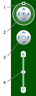
Google Earth navigation controls offer the same type of navigation action that you can achieve with mouse navigation. In addition, you can use the controls to zoom and swoop (perhaps for a perspective on terrain) or to rotate your view. The following diagram shows the controls and explains their functions.
New Navigation Controls

Click the north up button to reset the view so that north is at the top of the screen. Click and drag the ring to rotate your view.
Use the Look joystick to look around from a single vantage point, as if you were turning your head. Click an arrow to look in that direction or continue to press down on the mouse button and drag to change your view.
Use the Move joystick to move your position from one place to another. Click an arrow to move in that direction or continue to press down on the mouse button and drag to move.
Use the zoom slider to zoom in or out (+ to zoom in, - to zoom out). Double-click the icons at the end of the slider to reset the zoom all the way in or out. As you move closer to the ground, Google Earth swoops (tilts) to change your viewing angle to be parallel to the Earth's surface.
You can also use the keyboard to control navigation. See 3D Viewer Navigation in Keyboard Controls for more information.


  • Imagery Dates - You will now be able to easily see the dates when imagery was taken for most imagery (but, not all).

  • More 3D buildings, faster loading - Faster loading the 3D building models.

  • New photo-textured cities.

  • Day/Night Lighting - Real-time sunlight lighting option. Daylight/Time slider control of the sun's shadow position across the globe.

  • New Languages Support - even UK English!

Source:

http://earth.google.com/intl/en_uk/userguide/v4/

Download Google Earth 4.3

Labels: , , , , , ,