->

16 December 2008

Tiger Data 2008 Released

Tiger Data 2008 Released

update 20/01/2009
A new potentially good source is for Road Linework [editable in a GIS]
is the
National Transportation Atlas Database
http://www.bts.gov/publications/national_transportation_atlas_database/2008/
Now Available in ESRI Shapefile format

Tiger 2008 - US Census Bureau Logo
(Topologically Integrated Geographic Encoding and Referencing system)

The US Census Bureau has recently released the Tiger 2008 data to the public to download and use freely.

Shapefiles (most GIS Software can view them)
http://www2.census.gov/cgi-bin/shapefiles/national-files
Don't have a GIS?
A free Open Source GIS is Quantum GIS


Technical details are available

http://www.census.gov/geo/www/tiger/tgrshp2008/TGRSHP08.pdf

FTP available
ftp://ftp2.census.gov/geo/tiger/TIGER2008/

This updates the earlier post (April 2008)
http://mapperz.blogspot.com/2008/04/tiger-2007-data-release-esri-shapefile.html

The one thing the US Census website lacks is a geographical way of selecting the data.
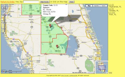
County Finder at Maps Huge.com
Maps Huge helps users find neighbouring (neighboring) counties

Need to know an area in a visual way?
try
http://maps.huge.info/county.htm
or
http://maps.forum.nu/gm_main.html

Labels: , , , , ,

01 April 2008

Tiger 2007 Data Release (ESRI Shapefile)

Tiger 2007 Data Release (ESRI Shapefile)


Finally in a much more 'user friendly' format.... Tiger 2007 Data Direct ArcMap
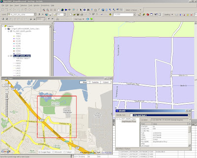
A very quick example of Tiger 2007 in ArcMap - No editing, labels direct from the downloaded files.
Very useable.

"The TIGER/Line Shapefiles are extracts containing selected geographic and cartographic information from the Census Bureau's MAF/TIGER® (Master Address File / Topologically Integrated Geographic Encoding and Referencing) database. The MAF/TIGER database was developed at the Census Bureau to support a variety of geographic programs and operations including functions such as mapping, geocoding, and geographic reference files that are used in decennial and economic censuses and sample survey programs. Spatial data for geographic features such as roads, railroads, rivers, and lakes, as well as legal and statistical geographic areas are included in the product. Other information about these features, such as the name, the type of feature, address ranges, and the geographic relationship to other features, also are inlcuded. The TIGER/Line Shapefiles are made available to the public and are typically used to provide the digital map base for a Geographic Information System or for mapping software.

The 2007 TIGER/Line Shapefiles contain current geographic areas (boundaries of governmental units as of January 1, 2007) and Census 2000 vintage geography. The shapefiles also contain some additional post January 1, 2007 feature updates reported in the Boundary and Annexation Survey (BAS). The 2007 TIGER/Line Shapefiles contain realigned street feature coordinates as a result of the MAF/TIGER Accuracy Improvement Project. The Census Bureau is providing a list of counties that have not been realigned via the MTAIP process."

http://www.census.gov/geo/www/tiger/tgrshp2007/tgrshp2007.htm


Metadata Notes
The 2007 TIGER/Line metadata in Extensible Markup Language (XML) format is included with each compressed TIGER/Line Shapefile.

The Spatial Metadata Identifier (SMID) in the All Lines shapefile identifies the source of the coordinates for each line segment and provides the link between the TIGER/Line Shapefile and the source and horizontal spatial accuracy information. Please note that the horizontal spatial accuracy, where reported in the metadata, refers to the realigned street features identified as matched to a positionally accurate source file with that accuracy. Individual feature-based horizontal spatial accuracy does not apply to the entirety of the TIGER/Line Shapefile.

The North American Datum of 1983 was used in the 48 contiguous states, the District of Columbia, Alaska, Hawaii, (only Oahu Island within Honolulu County, HI (15003)), Puerto Rico, the Virgin Islands of the United States, and the Pacific Island Areas. Even though a NAD83 PRJ file will accompany every TIGER/Line Shapefile, there are a few island areas in TIGER that have not gone through the NAD83 transformation process and are still in local astronomic datums. For detailed information regarding these exceptions please refer to the metadata that is included with each TIGER/Line Shapefile.

DIRECT TO THE DATA


or FTP SITE

Labels: , , , ,

18 February 2008

TIGER,TIGER OpenStreetMap

TIGER, TIGER in OpenStreetMap

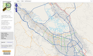
Tiger Santa Clara Open Street Map

Well ahead of schedule TIGER data (USA) has been successfully imported to OpenStreetMap

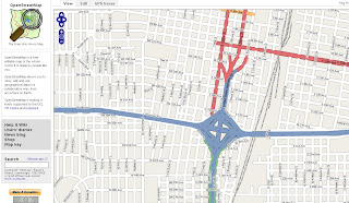
Tiger Data Amarillo USA - OSM
Clean, attributed data in OpenStreetMap

"OpenStreetMap (OSM) has completed the bulk import of comprehensive street and highway data for the United States, months ahead of the project's original estimates. The massive data set originated with the US Census Bureau's public domain map database, and importing it required a dedicated upload process running around the clock since August 2007. The imported data will still require human editing and error-correction, but the completed task is a major milestone for the OSM project."


How was this done so fast?
Once happy with the results, the project began importing the data into the main OSM system using three dedicated daemons running concurrently. Requiring all of the imported data to go through the OSM server's API just like manually collected GPS trace data meant it was a time-consuming process, but it was safer than attempting to bypass the API and alter the database directly.

Quadtiles to the rescue...
At the beginning of the process, the predicted completion date hovered between late May and early June 2008. Luckily, admin Tom Hughes found a way to re-index the database using quadtiles, resulting in greatly shortened database lookup times.

"Quadtiles recursively split each quadrant of the map into four sub-quadrants, allowing for better space efficiency by only subdividing those quadrants that require more detail -- a quadrant containing only ocean and therefore no roads, for example, would not require subdivision, whereas a metropolitan city center would."

Community Help
Now the real work begins, and you can help
The TIGER data set covers 6% of the Earth's surface. Its successful import does not mean that the work is finished. Users who have collected their own GPS logs in areas covered by the TIGER maps and uploaded the resulting data report sporadic problems with TIGER's information. Problems include misalignment of roads, missing features (including the regular absence of on-ramps and access roads, and representation of divided highways as a single road), and occasional confusion on features such as cul-de-sacs. Since the TIGER map data was produced from aerial photography, and was originally intended to assist Census Bureau officials in the field, such problems are bound to occur and are unlikely to have undergone official correction.

History
"OSM has performed one other bulk data import. In July 2007, AND Automotive Navigation Data donated a comprehensive road map of the Netherlands and highway system maps of India and China. The Netherlands import was completed last fall, but the data for the India and China import has yet to be released to the project.

Future
Although other prospects for large-scale map donations have been discussed, none are on the horizon. The addition of the AND and TIGER information gives the OSM project a helpful boost, but the bulk of the future work remains in the hands of individual users, each contributing their input toward the whole."

Some Random Places
Mountain View, Santa Clara
http://www.openstreetmap.org/?lat=37.3873&lon=-122.0877
&zoom=12&layers=B0FT

Seattle
http://www.openstreetmap.org/?lat=47.60933&lon=-122.33515
&zoom=15&layers=B0FT

Orlando
http://www.openstreetmap.org/?lat=28.6276&lon=-81.3724
&zoom=12&layers=B0FT

Labels: , , , ,