->

24 March 2010

Geofuse - Discover GeoEye Images by Map

Geofuse - Discover GeoEye Images by Map

"GeoFUSE Online Maps differs slightly from Google Maps™ as the primary purpose of GeoFUSE Online Maps is to allow both novice and expert users alike to quickly locate and identify available GeoEye archive imagery around the globe. "

Geofuse - GeoEye Images by Map
When suitably zoomed in the toolbar becomes active to generate a polygon or find GeoEye images by extent.
http://tinyurl.com/geofuse-oz

Footprints and Previewing GeoEye Images
Image Catalog search results footprints are displayed on top of the map along with any selected image previews. Footprint and image previews can be turned on and off using the icons in the Image Catalog search results table to the left of the map.

More map help http://geofuse.geoeye.com/help/online-maps.aspx#gettingstarted

Geofuse - GeoEye Images by Map - New Zealand
New Zealand Example
http://tinyurl.com/geofuse-nz

Only real suggestion is the long permalink can they be strunk? Urls with polygons are very long hence this post using tinyurl.

GeoFuse Map
http://geofuse.geoeye.com/maps/Map.aspx#

Labels: , , , ,

18 January 2010

OSM Routing for Port-au-Prince in Haiti

OSM Routing for Port-au-Prince in Haiti

update: 7pm 18/01/2010

Earthquake Geospatial Research Portal

Free GIS datasets and online resources related to the Haiti Earthquake can be found here.
http://cegrp.cga.harvard.edu/content/haiti-earthquake-data

Open Street Map doing outstanding work (and too many people to thank)

Fully Routing with barriers and obstacles where known.


Port au Prince Haiti Routing Map

Routing & Mapping can help rescuers and target areas with distribution aid.
http://openls.geog.uni-heidelberg.de/osm-haiti/#
*includes high resolution imagery from Geoeye (many thanks)

You can help:

Labels: , , , , , , , , ,

14 December 2009

Mapquest Streetview (called 360) - Street Level Imagery

Mapquest Streetview (called 360) - Street Level Imagery
Mapquest Steetview 360
You can now view MapQuest Maps in a whole new way. We have developed a simple, easy-to-use interface that fits seamlessly into the MapQuest mapping experience you have come to know and understand. 360 View provides fantastic panoramic views (360° horizontally and 160° vertically) of any given image within the 360 View coverage area
*selective USA Cities only
Mapquest Steetview 360 mode
orange glow represents 360 street level imagery available when the '360 view' option is on.

The quality of the imagery is not as high resolution as Google (Streetview) or Bing Streetside but then they require post-processing bluring faces, mapquest does not.
The Orange 'bubbles in' 360 mode could be made transparent but do indicate direction of the next photo in a simple manner.


Mapquest API
currently 360 mode is not available in the mapquest api
http://developer.mapquest.com/web/products/beta-releases

source:
http://blog.mapquest.com/2009/12/11/street-level-imagery-comes-to-mapquest-com-as-360-view/
screen shots:
http://www.mapquest.com/360-details

Labels: , , , ,

10 August 2009

Geographic Imager for Adobe Photoshop

Geographic Imager for Adobe Photoshop:


The Geographic Imager for Adobe Photoshop CS3 and CS4 allows you
to access all the tools and functions quickly and easily for
Imagery Manipulation (Remote Sensing).

Retain spatial properties

Geographic Imager allows the use of Adobe Photoshop native
functionality without destroying the spatial properties of an image.

Import/Export imagery

Import and manage georeferenced imagery such as GeoTIFF, JPG, PSD and
other Photoshop compatible raster data formats.
Export reference files as standard industry formats.

Import elevation data

Now import DEM formats such as ArcInfo ASCII Grid, ArcInfo Binary Grid, DEM USGS/CDED ASCII, Military Electations Data/DTED and SRTM. Also new support for other formats such as

ECW, JPEG 2000 and MrSID.

Georeference non-referenced imagery

Import or add ground control points for accurate georeferencing of images with multiple transformation types supported. Save GCP data as reference files. Quick reference using one or two tie-points.

Mosaic

Mosaic individual images to create a seamless image. Retain images as separate layers or flatten to create one image. Now supports image transformation during Mosaic, making it easier to get the images the way you want. Also, now create seamless mosaics of images with different coordinate systems, pixel sizes, channels and colour modes.

Tile

Tile an image into multiple images by tile size or count. Automatically saves tiles using sequential naming.

Crop

The GeoCrop tool allows image cropping based on a combination of pixels or geographic coordinates (geodetic and projected). Also GeoCrop Import lets you crop images before they are opened.


Merge and Split Channels

Adobe Photoshop Merge and Split Channels are now supported. Create false- and true-colour images while retaining georeferencing.

Scripting

Allows for use of Geographic Imager tasks in conjunction with Adobe Photoshop automation tools.

Cost:
Geographic Imager Full Version
* version 2.x for Adobe Photoshop CS2*, CS3 & CS4
$699 (£419**)
Geographic Imager upgrade
* from version 1.x to 2.x
$319 (£191**)
Geographic Imager Floating licenses

* US$1,599 for each concurrent user when 1 to 4 licenses are purchased
* pricing available for 5 or more concurrent users.
$1,599 (£959**)
Geographic Imager & MAPublisher bundle

* Geographic Imager 2.x and MAPublisher 8.x
$1,749 (£1,049**)
* Adobe Photoshop CS2 users require Geographic Imager 2.0
Shipping
All products are shipped by UPS by default. If you prefer another method or to have the shipping charges billed to your account please indicate so when ordering. All prices are shown in U.S. dollars ($USD). Shipping charges (for a single item) are as follows:

* Economy delivery to anywhere in the US and Canada — $35
* Overnight delivery to anywhere in the US and Canada — US$55
* Delivery to anywhere in Western Europe — $85 (£51**)
* Delivery to most other places — $120
** price correct/conversion on 10/08/2009
Image Sources: http://www.avenza.com/geographicimager

Labels: , , , , , ,

27 March 2008

Virtual Earth Update (40TB Worth)

Virtual Earth Update (40TB Worth)

Another huge amount of tiles updated - this list is long
http://blogs.msdn.com/virtualearth/archive/2008/03/25/new-imagery-march-2008.aspx


UK
Birds Eye Views


London

Wigan

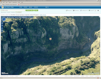
Cheddar

Cheddar Gorge BirdsEye View Live Maps
Cheddar Gorge in BirdsEye Mode
Cheddar Gorge 3D View Live Maps
Cheddar Gorge in 3D Mode

Harlow

Sawbridgeworth


Orthophoto's (Aerial)

Norwich


Ipswich

Cambridge

Hereford

Ludlow

Diddlebury Area

Coventry (South)

Bury St. Edmonds

Labels: , , , ,

04 June 2007

Google Earth Images Massive Update for UK

Mapperz noticed late last night that Google Earth images for England and Wales have dramatically improved in resolution of aerial images.

Other areas of Europe and the World have also been updated.

full list:

Germany now looks much better thanks to special colour mapping techniques which were used for Switzerland previously!
UK updated - Most of England is now in high resolution.
Parts of Greenland
Antarctica - some strips of high resolution down here
Parts of Canada with new high resolution, big area around Toronto
Catalonia part of Spain
State of Alabama
St. Paul, Minnesota
Puerto Rico has more high resolution
Iran has lots of new Digital Globe satellite strips
New Zealand has some new coverage
Parts of Russia

from the Google Earth Blog

Google Earth is now onto Version 4.1 (beta)

Labels: , , , , ,

24 May 2007

The People’s Map (Beta)

The People’s Map (Beta) for the UK

Peoples Map Beta


The People’s Map is free for private and Non-Commercial use.

Layers available:
  1. The People's Map
  2. Get Mapping Imagery
  3. Out of Copyright Map

"The People's Map is a revolutionary new concept in mapping. Professional and Private users maintain the People's Map by providing update information using the editing suite. The information is checked and compiled into high quality cartographic maps at all scales with fair and straightforward licensing."


Terms of Use and Copyright Information here

Posted by Mapperz in Canada

Labels: , , , , ,

02 March 2007

Swiss Alps Super High Res in Google Earth/Google Maps

Swiss Alps in Glossy Super High Res in Google Earth/Google Maps

Swiss Alps High Res

Google announce another imagery and terrain update:

Highlights are:
  • Entire country of Switzerland at 50cm and many Swiss cities at 25cm ( courtesy of Endoxon)
  • Entire country of Switzerland terrain at 10m, the Swiss Alps are now super high-res!
  • Entire country of Denmark at 50cm
  • Australia day flyover
  • Cities of France: Lyon; Le Mans; Lourdes; Reims; Nancy; Limoges; Lille; Arles
  • Potsdam and Magdeburg, Germany
  • Barcelona, Belem, CapeTown, Galapagos (Isabella Island), Manaus, Mt Saint Helens, Recife, Rio, Venice)
  • Full state coverage for Wyoming & Utah
  • Significant amounts of new Digital Globe data
Google now shows you the dates of the images

Google Earth Image Dates

select 'Digital Globe Coverage' in the Layers to view this information (useful for reference)


Source: http://bbs.keyhole.com/ubb/showthreaded.php/Cat/0/Number/815618
Via: The Map Room
More Links at Google Maps Mania

More info over at Ogle Earth

Labels: , , , , ,

04 December 2006

Open Street Map gets Yahoo! Imagery Boost

Good news for Open Street Map (OSM) as Yahoo! have agreed to let OSM use their aerial imagery
From this imagery (15 meter per pixels)
So from this....

To this Yahoo Imagery
to this...

and with a bit of jiggery pokery...

Yahoo Images vectorized applet
create vector road centerlines

Well done OSM

More info at Geobloggers

Labels: , , ,