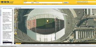
192.com Aerial Imagery Updated
192.com Aerial Imagery Updated
192.com have updated the to most up-to-date online aerial photography for London.
High Resolution aerial photography from Getmapping.com
The new imagery has been captured using the latest digital camera technology with each image pixel equivalent to 12.5cm from the ground. The result are high quailty true-colour photographs - right down to road markings and visable street furniture.
This data is more up to date than google 'satellite' mode and microsoft bing aerial (multimap) mapping sources.

New orthorectified aerial images on 192.com include Wembley Stadium including the Wembley Arch and Wimbledon’s new multi-million centre court roof. Also visible on the new photography is the beginning of the preparations for The Ashes Test Matches at Lords and the Oval Cricket grounds.
"This new photography shows a step forward for aerial imagery used on the net and we believe it will help our users to get richer search results and a more enjoyable experience. The images are truly amazing and even let people check out the most recent aerial shots of their home."
Dominic Blackburn - Product Director
Check the new updated aerial photographs
http://www.192.com/places/
A couple links to some well know landmarks:
Buckingham Palace
http://www.192.com/places/search/?Type=All&place=BUCKINGHAM%20PALACE&gre=529168&grn=179747
(includes Super Zoom Mode)
Wembley Stadium
http://www.192.com/places/search/?location=wembley%20stadium&distance=1838&page=1&searchType=All&place=WEMBLEY%20STADIUM&gre=519384&grn=185519
source:http://www.journalism.co.uk/66/articles/535540.php
& email - thanks to Neil Watts - neil.watts@192.com
Labels: 12.5cm, 192.com, Aerial Imagery, London, Super, updated, Zoom
![MBR [Minimum Bounding Rectangle] Example MBR [Minimum Bounding Rectangle] Example](https://blogger.googleusercontent.com/img/b/R29vZ2xl/AVvXsEiCoiJKK0PT6q037FnJEbBPs-c5nZ56rrzgTlWPPmJgSq8t1-LU8lVAkr7A2ki5aydfSe-wZeAo59i_KK6K35xKmsm4xIKnuD8HpapXgeVsps2R_pVbvzUCc48qiQuymM1MZdHj/s400/MBR_Example.bmp)


