Open Street Map in Shapefile Format!
Open Street Map in Shapefile Format
For more information on progress this see blog.
http://itoworld.blogspot.com/
This is top news for GIS users who support Open Street Map, there is no longer any need to convert the osm.bz2 to shapefiles as it is supplied in shape format now.

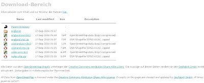
Directory Listing now with Shapefiles
This saves time (and money)

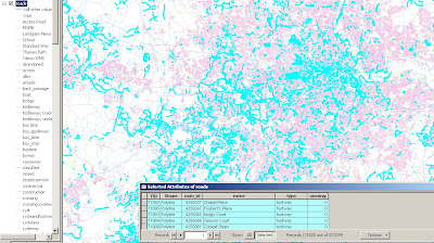
Extracting Footpaths - No conversion needed only re-projecting the data for the UK into British National Grid.
Full Directory
http://download.geofabrik.de/osm/
(updated daily)
Well Done to the http://www.geofabrik.de/ Team
To Do:
OSM has already got export to EPS,PDF,Postscript, JPEG,PNG,GIF
(see previous post)
http://mapperz.blogspot.com/2008/04/openstreetmap
-now-exports-maps.html
http://mapperz.blogspot.com/2008/04/openstreetmap
-data-in-globalmapper-fast.html (not needed now?)
TO DO: (fictional to-date)
Load into a File Geodatabase
Check Attribution (Q&A)
Build Topology - Clean Data (snapping linework)
Build Network (checking phase) export to SQL
Routing (via Postgres and PG Routing)
Create Buffering Routes - find my nearest... (pub on my footpath route)
(load into an online mapping api and have UK footpaths route-able!)
source:http://freegeographytools.com/
Labels: Daily, Downloads, Geofabrik, OSM, Shapefiles


5 Comments:
Can I use OSM for maps at work? Its under a CC license, but not sure if its a clear answer?
Oxford University and Heliski University use OSM mapping as do many voluntary organisations. If you are a mega-corp using it for a high profile application then you may want to wait, however in other cases just write 'cc-by-sa www.openstreetmap.org and contributors' under your map and everyone will be happy
Mapperz.... this is not a comment about this post, but can we talk about what Ito World Ltd is doing... We are good exciting mapping stuff with OSM data and are based in London, Suffolk and Cambridge and would love to meet up with you. Here is a link to our main OSM product which is aimed squarely at supporting the map creation effort. We are now about to move our focus to using the data for professional purposes. Regards, Peter Miller (PeterIto) http://itoworld.blogspot.com/
I've tried to open this file in ArcGIS 10.0:
http://download.geofabrik.de/osm/europe/spain.shp.zip
But is isn't possible I only get the attribute layer not the geometry. Maybe something wrong with the conversion?
Your file has the .zip extension so you may need to unzip it first, so that it has just the .shp extension
Post a Comment
<< Home