->

25 May 2010

ParkInfo.org Parks and Recreation Sites

ParkInfo.org - Exciting New Cartography for Web Access to Parks and Recreation Sites

ParkInfo.org Full Parks Info in 3D
View Data from 3d ParkInfo.org combines the cartographic and the terrain to produce highly effective visualisations of the campgrounds and park boundary information.

The non-profit www.greeninfo.org Network has just put up a new version of its ParkInfo web site, offering up some great web map cartography that shows every public parks and protected open space in California, along with nifty integration of Google Maps API and Open Street Map data, Google Earth overlays, multiple search tools and more.
ParkInfo.org Map Parks
Full information on Parks, Campground at a click of a button.

ParkInfo uses the California Protected Areas Database (CPAD), a comprehensive and highly accurate GIS data set of everything from neighborhood tot lots to vast federal wilderness areas, almost all mapped to official property ownership boundaries. GreenInfo Network, which works for public interest groups on a wide range of GIS and information technology projects, maintains the 49 million acre, 15,000 unit CPAD database. CPAD is available for non-commercial use at www.calands.org , and has been developed with ESRI ArcGIS software.

The web site features the CPAD lands that are open to public use (some require a permit). The site lets users search near an address, by park or city name, or in a zip code. Search results show as lists and on the map and all parks on the map are clickable with more information - including a direct web link, driving/transit directions (via Google Maps Directions) and a link to Bing's Birdseye view of the site. The web map can also be enlarged to full screen to take advantage of the great cartography.

GreenInfo shifted from using Google's Streets view to its own custom MapView, which features 10 meter DEM data in an attractive hillshade and well-styled Open Street Map streets. When fully zoomed in, users also see contour lines. In addition to Satellite view, users can also easily browse all the ParkInfo data using the Google Earth plugin. ParkInfo also has all public campgrounds in the state and a selection of Open Street Map trails.
ParkInfo.org TopOSM Map
TopOSM terrain tiles have been used to show relief in 2D view for ParksInfo.org

Map tiles were created using the TopOSM scripts and rendering process created by Lars Ahlzen see http://toposm.com/usw/ for example. Areas, streets and labels are rendered using Mapnik. PostgreSQL with the PostGIS extension provides the spatial query capabilities for ParkInfo while a MapServer Web Map Service (WMS) GetFeatureInfo request returns park details when a user clicks on a park.

View the Map in 2D and 3D - http://www.parkinfo.org/

ParkInfo can be adapted into other organizations and agencies' web sites, allowing them to offer full search of public recreational opportunities. The State of California Department of Parks and Recreation has already done so at http://Findrecreation.parks.ca.gov

Composed by Larry Orman from http://www.greeninfo.org/ with thanks from Mapperz
GreenInfo is exploring an API as well as expanding ParkInfo to other U.S. states. Contact them at: parkinfo@greeninfo.org

Labels: , , , , , ,

05 November 2009

OpenStreetMap Data 'On Demand' with Quantum GIS 'Mimas'

OpenStreetMap Data 'On Demand' with Quantum GIS 'Mimas'

Updated 07/11/2009

Getting the data you want.

One of the hardest things about OpenStreetMap [#OSM] is getting access to the data you want and for the location you require.
You can download large files for entire regions or countries, but why only if your going to use a small amount.

CloudMade gives you this by country. http://downloads.cloudmade.com/

Here is a solution - All software is FREE and Open Source so no excuses.

OSM direct access within Quantum and saved in Postgres
Viewing styled (Automatically) Open Street Map Data in Quantum GIS 'Mimas' [QGIS]
The data has been downloaded directly from the Open Street Map Servers [most up to date data].
**There are area limitions controlled by OpenStreetMap Servers, the plugin will warn you of this issue if required.
You also can edit, select features, query features and do spatial geoprocessing (buffer,intersect etc) on the data.

Clarification on editing the OSM data.

After selecting the area, download to a location on your computer .osm format.
you will get 3 layers called
osm points*
osm lines*
osm polygons*
*not editable
now these are 'representations' only, so you are required to load the .osm file in again.
use the openstreetmap plugin to do this
This will create two layers ways and nodes - These can be edited - right click/toggle editing.
Now you can edit your OpenStreetMap data.

Import Issues to Edit your on-demand openstreetmap data.

Please note: There are 2 'OpenStreetMap' Plugins available - both are required. But to use the editor with the data downloaded please use the 'Import OpenStreetMap' version - not the Load OSM option.


You will need the development version of Quantum GIS 'Mimas'

http://blog.qgis.org/node/138
http://qgis.org/en/download/current-software.html
http://download.osgeo.org/qgis/win32/QGIS-1.3.0-3-No-GrassSetup.exe [Direct link to Windows file 28.1mb]

Spatial Database or Shapefile?
If you want to store your OSM data and use it for other projects then storing it in a Postgres Spatial Database is a good idea.
http://www.postgresql.org/download/

With Postgis 1.4 (1.5 in dev) you can speed up functions of geoprocessing and achieve more accurate results.
Download - http://postgis.refractions.net/download/ [install after Postgres].

Or if you just want it as a common file type you can just save out to shapefile.
Good if you want to share it to others with minimum impact.

Note: There are many new plugins for Quantum GIS

QGIS plugin manager
For this please use the OpenStreetMap Plugin (Version 0.5) [top]
and if you choose the postgres/postgis route a very useful plugin 'PostGIS manager (Version 0.5.4)' gives users a Graphical User Interface for managing Postgres/Postgis functions.
*versions maybe different in future.

This give users the power and speed. This gives Quantum GIS the edge on Open Source and Commercial GIS by breaking down the limitations and access to geographical data directly.

Labels: , , , , , , , ,

11 September 2009

MapOSMatic - Free Street Map Index Generation

MapOSMatic - Free Street Map Index Generation

**for France only but is hoping to expand in the near future.

Combining the OpenStreetMap mapping platform with Postgres (using PostGIS Functions) for creation of 'Bingo' grid maps with street indexes.

Example
Chavagne Open Street Map - MapOSMaticChavagne Map Index - MapOSMatic
source: http://www.maposmatic.org/smedia/chavagne.png
http://www.maposmatic.org/smedia/chavagne_index.png
(large .png's some web browsers can choke on image size being large)

This makes it very useful to print and use on your travels or to help OpenStreetMap fill in any missing or changed names - you can contribute here with over 135,000 budding OSM'ers.
Note: you don't have to have a GPS device to contribute.
Paper and Pencil works! (see http://walking-papers.org/)

How does this work? (techie stuff bit)
  • Renders the map using OpenStreetMap data and the OpenStreetMap Mapnik stylesheet;
  • Renders on top of the map, using Mapnik, the grid of 500 meters squares, the labels of the squares, and a few other informations on the map (copyright, scale, etc.);
  • Greys out all the area outside the city if we find its administrative boundary;
  • Renders an index of the streets, based on OpenStreetMap data and the intersection of the streets with the squares on the map.
"On our server, we run a PostgreSQL server, with the PostGIS extension. In this PostgreSQL server, we have loaded the full OpenStreetMap data for the metropolitan France, using the dumps from Geofabrik and the osm2pgsql tool."

This web service has been called MapOSMatic, like map-o-matic but with a reference to OpenStreetMap (OSM). The web service is written in Python using Django. It is responsible for storing the rendering requests and displaying the result of these requests. The rendering itself takes place asynchronously through the maposmaticd daemon. This daemon does only one rendering at a time, which is very important because of the CPU and I/O intensive nature of the map rendering process.

If you would like to contribute to this project then more information is available:
http://www.maposmatic.org/about/

Mapperz looks forward to it expanding across the rest Europe and the rest of the World.

Labels: , , , , , , ,

26 March 2008

Postgres Plus Released (25-Mar-08)

Postgres Plus has been launched

"Postgres Plus is an easy-to-use lightning-fast and massively scalable open source database for today's Web 2.0 and next generation applications."

Postgres Plus
Postgres Plus benefits include:
  • Fully open source and pre-configured binary distribution supports the most popular environments, including Linux 32 and 64, Windows, and Mac
  • 5-minute install automatically delivers the most commonly needed PostgreSQL add-ons, including advanced encryption and client connectors for Java, Ruby/Rails, PHP, Ajax, J2EE, and REST/Web Services
  • Automated MySQL migration tools let you move existing applications in no time
  • Update notification service lets you know about important updates that need to be installed

*Postgres Plus is "spatially enabled", allowing it to be used as a back-end spatial database for geographic information systems (GIS) or any of the Mapping API's out there (Gooogle Maps API, Virtual Earth API, Yahoo Maps API('s), etc)).

Getting Started, with walk-through screenshots available
http://www.enterprisedb.com/learning/getting_started.do

Documentation
http://www.enterprisedb.com/learning/documentation.do

Download (Mac, Windows , Linux)
http://www.enterprisedb.com/products/download.do
(Windows Version is 116mb)


Please Note: "Postgres Plus Advanced Server (Developer)" is Free
Postgres Plus Advanced Server (Subscription) is $5,995 per socket


Postgres Plus is Compatible with PostGIS
http://postgis.refractions.net/

phpPgAdmin 4.2-Beta-2 is also available
http://phppgadmin.sourceforge.net/?page=download

Labels: , , , , ,

25 February 2008

What's New in ArcGIS 9.3?

What's New in ArcGIS 9.3?
ArcGIS 9.3 is expected to be available in the third quarter of 2008.

ArcGIS Desktop
The new Convert Graphics to Features dialog at ArcGIS 9.3
A new Convert Graphics to Features dialog has been added to allow you to create features by drawing graphics without using the editor.
For this function now go here ( Tools for Graphics and Shapes v. 1.1.76).
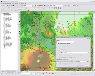

ArcGis 9.3 - Converting graphics to shapes

Pause Labeling
A new button in the Labeling toolbar lets you temporarily pause labeling to increase performance while you assemble the other layers in your map or do analysis. This saves you having to turn labeling off completely.

Manage Bookmarks
Bookmarks are much easier to access. You can also re-order and sort them, and export and load them between different data frames, maps and globes.

"Bookmarks are easier to access with the new Bookmarks pulldown menu. The 9.3 Bookmark Manager dialog lets you reorder bookmarks anyway you want and save bookmarks to a file for loading into other data frames, maps or globes. You can update the extent of an existing bookmark without having to recreate it. You can also save bookmarks into your My Places dialog so you can use the same bookmark in any map or globe you work with."

Data View and Layout Synchronised
Layer legends in the Table of Contents (TOC) and on your map layout automatically use lighter colors for symbols in layers that have transparency applied to them.

Full Table Joins
When you join tables, all of the field properties & field aliases, are now retained which makes working with joins much easier. You can now perform joins between layers or tables with definition queries defined and the definition queries are respected correctly.
There is now a toggle between showing field name aliases and showing the underlying field names. You can also sort a table on multiple attributes.

Full Identify Attributes
Identify window, the dialog will now respect all the field properties, such as primary display field, field aliases and field visibility, of any layer or table in your map that represents that related data in your map. Also when you identify a feature, you can now immediately launch the properties dialog and attribute table of the layer that the feature belongs to directly from the Identify window. This saves you having to look for a specific layer in the Table of Contents and is particularly useful when your map contains a large number of layers.

Address Geocoder and Reverse Geocoder
The new Address Inspector lets you click on a map to get the nearest address to any location
A new reverse geocoding tool called the Address Inspector lets you click on a map to get the nearest address to any location, and you can add that address to the map as a label.

Export & Clip Raster Data
It is now easier to export raster data. A new option within the Export Raster Data dialog in ArcMap lets you clip the output raster to the extent of the selected graphic(s) on your map.

Relative Scale Bar (1 in = 5 miles)
In 9.3 you can customize the scale control so that scales are always reported in relative format.

There is a now way to display map scales throughout the ArcMap user interface in relative format, such as 1 in = 5 mi, in the units of your choice, making scales easier to understand.

Double click Layer File (opens ArcMap)
Layer files are now registered with the ArcGIS Desktop applications. Double-click LYR files in Windows Explorer, Outlook, Windows Desktop to add them into your current map or launch ArcMap if it is not already running.
You can also click on LYR files presented on Web pages to add them into your maps, which provides internet data publishers with a simple way to provide ArcGIS Desktop users with access to their map services.

New Cartographic Tools
WYSIWYG (What You See Is What You Get) editing of cartographic representations has been added. When moving representations on a map, you'll be able to see the symbology instead of the wireframe outline so that you can better see how the edit will impact your map.
The new representation marker dispersal tool reduces the complex one-to-many relationship to a simple dynamic map

New Geoprocessing Tools
have been added to help with cartographic production. Disperse Markers has been added to allow you to spread representation markers apart which are coincident or nearly coincident. The new 'Set Representation Control Points at Intersect tool', you can now add a control point where coincident features share vertices.
New geometric effects
Move, Rotate, Scale, Wave, Tapered Polygon, and Regular Polygon.

*When exporting to XML, there is more information available about cartographic representations & rules.

Enhancements to Geoprocessing.
Within ModelBuilder, variables are more flexible in models and the 'Feature Record Set' and 'Record Set Controls' have been improved. More control over your geoprocessing model's parameters such as if a parameter is optional or required and what variable values are acceptable as inputs.

Script tools can now have multi-value outputs. The Results Window now shows environment settings. The Python scripting experience has also been improved. Python can now be run within an ArcGIS process.

**Error messaging has been revamped to make errors more descriptive and better linked to the help system. Messages are now standardized across all products, including ArcGIS Desktop extensions. These new, more informative messages will make it easier to build scripts and models.

Tool progress
messaging has also been improved and now more accurately displays actual progress. Not only will you be able to see how long an operation will take, but you'll know if the operation is proceeding as planned and not in some unknown state.

The 'Near' tool has been made more flexible and will now work with more than points and lines. It will perform calculations to all features within a given search radius. The ability to join to the closest feature has been added to the Spatial Join tool, making it easier to merge attributes.

New Spatial Statistics Tools

A new 'Generate Spatial Weights' tool in 9.3 gives you a new way to model spatial relationships. Its use results in a spatial weights file that is re-usable, editable, and sharable. A new 'Ordinary Least Squares Regression' (OLS) tool help you decide if your data is suitable for analysis using a global model that is the most commonly used regression statistic. The new 'Geographically Weighted Regression' (GWR) tool uses a local model for regional variations and helps you understand how processes vary of space.

ArcGIS Server
  • Improved performance
  • On-demand caching and improved caching geoprocessing tools will allow you to create faster mapping services.
  • New image services will let you quickly publish imagery that is optimized for the Web.
  • Better diagnostics
  • Precise logs will enable you to easily identify bottlenecks and points of failure and improve your installation and configuration experience.
  • New options in Manager will make it easier for you to secure Web services and Web applications
More documentation
Major additions have been made to the online help and SDK documentation.

A new ArcGIS Server Resource Center brings together the set of online resources to help make you successful including blogs, samples, and best practices information.

Mapping API
ArcGIS Server 9.3 also introduces several important new features:
New REST and JavaScript APIs
These APIs will dramatically simplify your development experience and enable you to deliver fast and user-friendly mashup GIS Web applications.

***The JavaScript libraries will also let you embed ArcGIS Server maps, geocoding, and geoprocessing services into Google Maps API and Microsoft Virtual Earth API.

OGC and industry standards
New Open Geospatial Consortium (OGC) services support
Additional support for OGC and industry standards, such as Web Coverage Service (WCS), Transactional Web Feature Service (WFS-T), and KML 2.1, will improve your ability to integrate with virtually all the commonly accepted GIS and IT standards.
New PostgreSQL support - thank you ESRI! :)
(This gives you the ability to store and manage spatial information in this open source database system without ArcSDE.)

"The 9.3 release of ArcGIS Server represents a complete and integrated server-based GIS with significant quality enhancements and several new features that will make it even easier for you to create and manage end-user applications and services for spatial data management, visualization, and spatial analysis."

The Geodatabase
The geodatabase continues to be the common data storage and management framework for ArcGIS. At ArcGIS 9.3, the geodatabase offers improved spatial data management and enhanced capabilities for integration with enterprise systems.

ArcGIS 9.3 geodatabase enhancements include:
  • Raster data management. New geoprocessing tools make the transfer of unmanaged raster catalogs (in Microsoft Access personal geodatabases and file geodatabases) from one location to another much easier
  • Geodatabase replication. Microsoft Access personal geodatabases and file geodatabases can participate in one-way replication as child geodatabases
  • ArcGIS 9.3 allows for more detailed logging of geodatabase replication activity.
Direct Connect backward compatibility (clients will be happy)
ArcGIS 9.3 clients can make direct connections to pre-9.3 enterprise geodatabases (e.g., 9.2, 9.1, and 9.0).
Backward compatibility allows easier implementation of phased migration strategies for new ArcGIS releases.

Versioned editing
The Merge Geometries option enhances conflict and reconcile management.The Version Changes Viewer tool allows a version to be compared with an ancestor version without performing a reconcile operation.

Support for PostgreSQL (Open Source DBMS)
Enterprise geodatabases can be implemented on PostgreSQL with full support of the geodatabase data model.Vector geometry is stored in the ESRI spatial type.
PostGIS Open Source spatial type is supported.

Support for SQL Server 2008

The SQL Server 2008 release will introduce two spatial types: Geography and Geometry. These will be supported in enterprise geodatabases implemented on SQL Server 2008.

Operating System
New 64-bit platform support
Enterprise ArcSDE technology is now available as a native 64-bit application for Windows and Linux.

Source: ESRI (Mapperz edited for this post)

Labels: , , , , , ,
