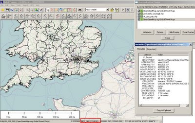
GlobalMapper v11 (Beta1) now with OpenStreetMap
GlobalMapper v11 (Beta1) now with OpenStreetMap
"Global Mapper just got even better."

Open Street Map as a background layer note: OSM Rasters are projected on the fly to British National Grid in this case.
But very useful now the Digitising Tool is updated and dock-able (also shown)
One of the best and affordable GIS software packages around just got a lot better.
Global Mapper v11 (beta1) now introduces OpenStreetMap as background layer for your map projects, It is also available to capture your own content.
New Features: summarised as the list is way too long
- Added free built-in access to global street-level maps from OpenStreetMap.org via the File->Download Online Imagery menu command.
- Added real-time display of current cursor information (location, distance, elevation) to 3D Path Profile dialog. In addition, you can now also click to define a sub-path on the 3D Path Profile dialog and get information about that sub-path displayed.
- Added support for scaling point symbols, adding custom point symbols from PNG, GIF, and JPG files, and easily creating symbols of custom sizes and colors for common shapes, like dots, squares, etc.
- Added toolbar for Digitizer/Edit Tool to make it easier to perform many commonly used operations.
- Added ability to create new line features by tracing them without clicking at each vertex with the Digitizer/Edit Tool.
- Added ability to rotate and scale features using the Digitizer/Edit Tool.
- Added support for numerous new formats, including Vertical Mapper (MapInfo) Grid, QCT, QED, HTF, SPS, BAG, and many others.
All of the other numerous changes are listed in the What's New document that is displayed during installation.
Prior to the v11.00 release we also plan on adding several other major features, including a map layout tool for more easily creating finished maps, PDF export, DWG export, access to better world-wide imagery, support for combining area features, and support for exporting new multi-band files.
Please visit this forum for the latest new and link to the download
A great way to allow many users to comment on new features and find potential bugs before a full released version
Download Global Mapper 11 (beta1) from here: (Includes full version for a limited number of days '15th July 2009')
There is also a 64-bit version of Global Mapper for 64-bit versions Windows
http://www.globalmapperforum.com/forums/announcement-news/4301-global-mapper-v11-00-beta-1-now-available.html
GlobalMapper v11 with be officially released v11.00 in approximately 1 month.
Unregistered Versions do work with this software though you will not be able to export data or overlay more than 4 layers of data. But for the price $349 or $129 (upgrade from v10) you get a lot features for your money.
Well done to the GlobalMapper Team always surpassing expectations.
New Related Post:
In addition there is a very good blog post showing you how to make your own customised maps/imagery for bing maps
http://www.soulsolutions.com.au/Blog/tabid/73/EntryId/610/Getting-your-custom-imagery-onto-Bing-Maps-with-Global-Mapper-and-the-Cloud.aspx
Labels: Beta1, Digitising Toolbar, Global Mapper, Layers, New Features, Open Street Map, v11


0 Comments:
Post a Comment
<< Home