Crime Maps England & Wales
Crime Maps England & Wales
Recorded crime in England and Wales on Google Maps - find what crimes have been committed in their neighbourhoods.
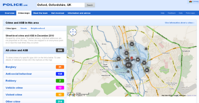
The map shows crime mapped to "an anonymous point on or near the road where they occurred." NOTE: Individual addresses are not pinpointed on the map.
To search for crime in an area users can enter a postcode or an address. The map will then display the crimes committed in a radius of the submitted location. The maps include a pretty neat marker clustering system and the number of crimes are also broken down by category.

Crime Maps for England and Wales - to Street Level - Search by postcode, town name or street.
Example:
http://www.police.uk/crime/?q=Oxford,%20Oxfordshire,%20UK#streets
Built on the API - http://www.police.uk/api/docs/
Source:
Google Maps Mania
http://googlemapsmania.blogspot.com/2011/01/uk-launches-national-crime-map.html
Interesting related post on the Guardian
http://www.guardian.co.uk/technology/2011/feb/02/uk-crime-maps-developers-unhappy
Labels: Crime, England, Google Maps, Police, Wales


0 Comments:
Post a Comment
<< Home