->

10 July 2008

ArcGIS JavaScript Extension for the Google Maps API

Updated see red and blue below

ArcGIS JavaScript Extension for the Google Maps API
"The ArcGIS JavaScript Extension for the Google Maps API allows you to use your ArcGIS maps and tasks in the framework of Google Maps. There are many reasons to use this extension to expose your GIS data. Perhaps your audience already knows how to use Google Maps. Perhaps you're already familiar with the Google Maps API. Or maybe you just like the look and feel of the Google base maps."

Google Maps + Powerful GIS Analysis
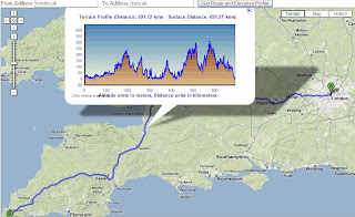
ESRI GMAP API Directions with profile UK
Here is a Google Maps Direction Route - with the added profile of the route generated by ArcServer. (click image to see live example)

Here is another example of adding GIS capabilities to Google Maps.
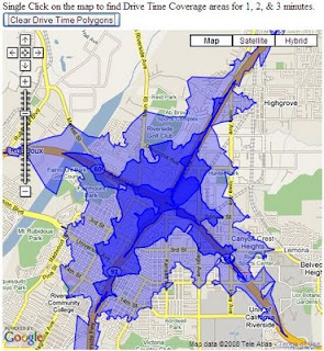
ESRI Google Maps API DriveTime
Drive Time Polygons (1,2 & 3 minute driving time polygons) on the fly - overlaid on Google Maps. (click image to see live example)
Custom version http://mapperz.googlepages.com/DriveTime_ESRI_GMAP.html
(Drive Time only works in the US and Canada)

How is this geo-processing action created?

Create Drive Time Polygons - ArcGIS Model
Image source: http://globe5.arcwebservices.com/arcgisoutput/Network_ESRI_DriveTime_US/CreateDriveTimePolygonsDisks.htm

ArcGIS comes with Model Builder here geoprocessing functions Make Service Area Layer, Add Locations are just some of the core processing elements to create Drive Time Polygons.

This is the start of some serious and powerful tools that will and can be built on to 'enrich' the map user.
This provides them with detailed information that can be manipulated and customized to the users specifications on the fly.

Other possibilities at the Geo-Processing Service examples here
  • Display your own maps on top of a Google Maps base map.
  • Execute a sequence of GIS models and display the results in Google Maps.
  • Search for features in your GIS data and display the results on Google Maps.
  • Find addresses using your own address locator and display the result on Google Maps.
  • Display attributes from your GIS data on the map using the Google Chart API.
  • Allows others to add GIS functionality from your server as a Google Mapplet.
The future looks bright with GIS software companies taking on popular mapping API's

Please note there is an ArcGIS JavaScript™ Extension for Microsoft Virtual Earth™ version as well.

Reported by Google Map Mania from this Blog


Labels: , , , , ,

04 January 2008

Graphics and Shapes Extension for ArcGIS

Graphics and Shapes Extension for ArcGIS 9.2

11/08/2008
A few extra functions have been added:
  • Added “Build Polygon” function
  • Added Polyline Azimuth options to “Calculate Geometry” tool.
  • Multiple minor edits to code and manual, described in full in manual.
  • Build 1.1.76 (January 10, 2008) Corrects a bug where the Spheroidal Length was being written to the wrong field.
version 1.1.76
http://arcscripts.esri.com/details.asp?dbid=15376

"Description: This extension includes a large suite of tools for calculating geometric attributes of vector features and for selecting and naming graphics. All tools are available at the ArcView license level."

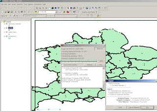
Jeff Jenness Graphics Shape Tools for ArcGIS Results
Cleaner and Faster than conventional 'ESRI' Toolsets (and a progress bar that works)


Jeff Jenness Graphics Shape Tools for ArcGIS
Simple layout of functions - much better than those geoprocessing tools in the toolbox you can never find the name for.

Tools for Graphics
Graphic Elements to Shapes
Select Graphic Elements by Type
Select All Graphic Elements
Unselect All Graphic Elements
Flip Graphic Element Selection
Zoom to Selected Graphic Elements
Name Graphic Elements
Tools for Shapes
Convert Polygons to Label Points
Convert Shapes to Centroids
Convert Shapes to Spherical Centroids (detailed method explained in PDF)
Convert Shapes to Vertices
Convert Polylines to Polygons
Convert Polygons to Polylines
Split Multipart Features
Combine Features
Calculate Geometry


"Jeff Jenness is an independent GIS consultant specializing in developing analytical applications for a wide variety of topics, although he most enjoys ecological and wildlife-related projects. He spent 16 years as a wildlife biologist with the USFS Rocky Mountain Research Station in Flagstaff, Arizona, mostly working on Mexican spotted owl research. Since starting his consulting business in 2000, he has worked with universities, businesses and governmental agencies around
the world, including a long-term contract with the United Nations Food and Agriculture Organization (FAO) for which he relocated to Rome, Italy for 3 months. His free ArcView tools have been downloaded from his website and the ESRI ArcScripts site over 190,000 times."

Full and comprehensive documentation (in PDF Format)
http://www.jennessent.com/downloads/Graphics_Shapes_Online.pdf

Source:
Jenness, J. 2008. Tools for Graphics and Shapes: Extension for ArcGIS. Jenness Enterprises.
Available at: http://www.jennessent.com/arcgis/shapes_graphics.htm

Labels: , , , , ,

30 November 2007

GeoWizards 9.7 for ArcGIS

GeoWizards 9.7 for ArcGIS
One of the best all round third party extensions you can get for ArcGIS - lots of functionality is *Free*

"A collection of powerful data manipulation, topology and surface functions for ArcGIS "

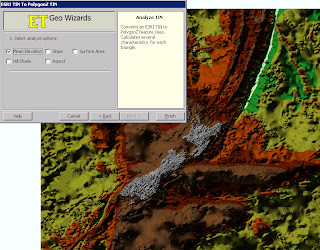
GeoWizards 9.7 TIN to Features Elevation

New functions are:

Map To Google Earth
Feature Class to Google Earth
Import from Google Earth
Polygon Characteristics
Perpendiculars from points to polylines
ESRI TIN To PolygonZ
Shape To ShapeZ
Point To Multipoint
Disperse Points
Random Points On Polylines
Random Points In Polygons

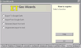
GeoWizards 9.7 Import or Export to Google Earth (KML)

* New method (number of vertices) included in the Split Polyline function
* Create Centerlines and Aggregate Polygons functions added to the version for ArcGIS 8.x.
* Scripting and toolbox implementation of the Ungenerate function added.
* Two new options added to the Features To Bounding Rectangles function.

Improved is:
* Improved performance and ability to handle large datasets. Functions affected:
o Build TIN
o Build Thiessen
o Aggregate Polygons
o Create Centerlines
* The Clean Dangles function allows user defined Fuzzy/Cluster tolerance to be assigned - better user control over the function.
* Improved error reporting
* **Several Functions improved to handle datasets with Z or M values. In the previous versions the input Z(M) values were dropped .
Functions affected:
o Clean Polygons
o Clean Polylines
o Erase
o Batch Erase
o Clean Dangling Nodes
o Clip
o Batch Clip
o Advanced Merge
o Symmetric Difference
o Merge Layers
o Split By Location

Bugs fixed:

Point Intersection function produces incorrect results if a polygon dataset that have polygons with holes is used.

A licensing problem in the Scripting and ToolBox implementations in ArcGIS 9.0.

***Inability of some of the functions to handle correctly datasets containing true Arcs. Functions affected:
Build Polygons
Clean Polygons

***Some of the tools of the ToolBox implementation produce an Windows error if used within a script run from the command prompt. The results are derived, but the tool breaks up the script. Tools affected:
o Clean Polygons
o Clean Polylines
o Clean Dangling Nodes
o Clip
o Erase
o Advanced Merge
o Symmetric Difference
o Thin Points
o Aggregate
o Interpolate Contours
o Create Centerlines
* Point Angle And Position function fails in some cases when the source paint dataset is a PGDB feature class
***Several functions fail if the output is File Geodatabase:
o Points To Polylines
o Points To PolylinesZM
o Points To PointsZM
o Points To Polygons
o Points To PolygonsZM
o Batch Drop Z(M)
o Batch Clip
o Batch Erase

** Only the version for ArcGIS 9.0 and above
*** Only the version for ArcGIS 9.2

One of the best and most useful functions that this extension has is 'Create Shapefile' inside ArcMap to create a new point, line or polygon.

For more information and to download this extension go to:
http://www.ian-ko.com/

Labels: , , , ,