Google API Geocoder Updates [ExtendedData]
Google API Geocoder Updates [ExtendedData]
Update 13/01/2009
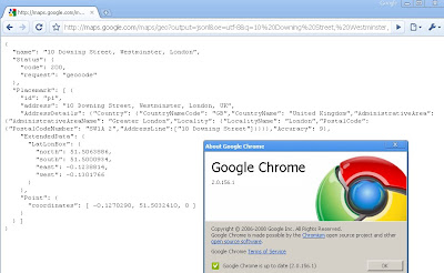
Google chrome users will be happy to know if you update to version (2.0.156.1)
your get the bounding box response from the Google Geocoder.

How to get Google Chrome 2 (Beta)?
http://dev.chromium.org/getting-involved/dev-channel
---------------------------------------------------------
Google Developers have been promising this for a few months now but finally it has made it to the real world. The Bounding Box has made it to the geocoder.
What is new?
Google Maps API Group has a suggestion/requests/issue tracker and one was for the bounding box (SW Corner and NE Corner) to be return when a geocode is sent to the google geocoding servers
Now you get the bounding box not just the centre coordinates
http://maps.google.com/maps/geo?output=jsonl&oe=utf-8&q=10%20Downing%20Street,%20Westminster,%20London&gl=uk&key=ABQIAAAA5heAddVpewIi0Vy-FvLfBBQ6SKP0Jc9Qt0dvx
now returns:
{Why the fuss?
"name": "10 Downing Street, Westminster, London",
"Status": {
"code": 200,
"request": "geocode"
},
"Placemark": [ {
"id": "p1",
"address": "10 Downing Street, Westminster, London, UK",
"AddressDetails": {"Country": {"CountryNameCode": "GB","CountryName":
"United Kingdom","AdministrativeArea": {"AdministrativeAreaName":
"Greater London","Locality": {"LocalityName": "London","PostalCode":
{"PostalCodeNumber": "SW1A 2","AddressLine":["10 Downing Street"]}}}}
,"Accuracy": 9},
"ExtendedData": {
"LatLonBox": {
"north": 51.5063886,
"south": 51.5000934,
"east": -0.1238814,
"west": -0.1301766
}
},
"Point": {
"coordinates": [ -0.1270290, 51.5032410, 0 ]
}
} ]
}
Well now this extra [Extended information] can be used to set zoom levels for your map.
"Now, in the KML/JSON outputs, you'll also get information about the
recommended bounding box associated with a geocode. You can then use
that along with map.getBoundsZoomLevel(GLatLngBounds) to set an
appropriate center and zoom after a geocode. "
Available
"in the HTTP Geocoder output and JS/Flash Geocoder functions."
Not Available currently in the static api.
Source:
http://groups.google.com/group/Google-Maps-API/browse_thread/thread/b95422a18f8701ed?hl=en#
Well Done Google Map API Team
Potential Future Requests
Altitude (feet or metres)
Time Zone (+1GMT -7 GMT etc)
Standardize the output between formats
Translate place names (Local >English or English to Local)
Accuracy of Rooftop geocoding response
Sea/Ocean Geocoder (Atlantic, Black Sea etc)
Labels: Bounding Box, Extended Data, Geocoder, Google Maps API, updated


2 Comments:
Strangly my Chrome browser just returns
{
"name": "10 Downing Street, Westminster, London",
"Status": {
"code": 610,
"request": "geocode"
}
}
While my Firefox 3.0.5 returns the whole dataset. Strange for another Google Product...
I think I understand that the bounding box data let's me figure out the recommended zoom level. Is this the maximum zoom level that will show satellite imagery? Could a recommended zoom not have satellite imagery? Or maybe there's satellite imagery for zoom levels higher than the recommended level.
I (and lots of other people) would love to find a way to determine the maximum zoom level for a location that includes satellite imagery.
Post a Comment
<< Home