ArcGIS 9.2 Cartographic Representations (part 2 of 5)
ESRI have done an excellent live seminar on Cartographic Representations (CR) presented by Peter Kasianchuk and Paul Hardy.
So why all this fuss on CR?

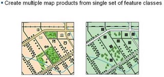
So using the same feature classes you can have more than one way to show (or represent) them. Think of it as set of layers (.lyr) or styles but attached to the feature class and can be edited directly like using Adobe Illustrator. More than one CR can be attached to the same feature class. So the same feature class can be vastly different but NOT affecting the geometry of that feature class.
Some questions answered
- ArcView can view and print cartographic representations. But not Create or Edit
In addition, the following new functionality is available in ArcEditor and ArcInfo.
- New cartographic editing and finishing capabilities
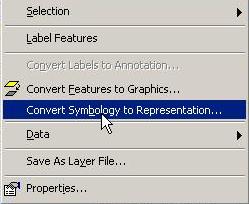
- Ability to create and edit cartographic representations and symbols of features without modifying feature locations.
- Ability to support offsetting graphic representations from the geometric location of a feature and storing these effects as part of the feature in the geodatabase.
- Ability to alter the graphic elements that make up a particular symbol (i.e., add, delete, move, or reshape something such as a single dash or marsh symbol within a fill pattern). These altered graphic elements can also be saved as part of the cartographic representation for a feature.
- Multiple cartographic representations
- Ability to store alternative cartographic representations as part of a feature record (like any other attribute). Use these different representations to create different maps from the same feature database.
- Cartographic representations will be "just another attribute" of a GIS feature.

- to be continued..


0 Comments:
Post a Comment
<< Home