->

06 November 2009

Network West Midlands - Live Bus, Train and Metro Map

Network West Midlands - Live Bus, Train and Metro Map

Network West Midlands - Live Bus, Train and Metro Map
Interactive Travel Map - this is information overlaid on to Google Maps showing live information from http://www.networkwestmidlands.co.uk/

The Interactive Live Map shows:
  • Bus stops (real time bus timetables, where available) rail stations (train departure and arrival times) and Metro stops.
  • See forthcoming departures (live for rail and bus)
  • Link through to full timetables relevant for each station and stop
  • See the 8-letter bus stop code for a particular bus stop.
The map functions:
  • Search box Type a road, town or village, postcode, bus stop name or bus stop code list matching bus stop results in the left panel.
  • Map top strip Tick/untick a checkbox to show/hide those map icons.
  • Map & markers You can pan, zoom and scroll using your mouse and the Google map controls (and the small map view in the bottom right-hand corner).
  • Left side links Select Rail or Metro to list local rail or metro stops
  • Left panel Bus stops matching your search are displayed as lists of links.
  • Quicklist Moves the map to an locality on the drop-down list.

View the Live Interactive Map
http://netwmtravelmap.com/

Labels: , , , , , , , ,

19 June 2009

Map Channels - June 2009

Map Channels - June 2009

A busy month for Map Channels: They have released the following 3 new features this month alone.


• 17 Jun 2009 : Iran Election Twitter Map

Iran Twitter Map - Map Channels
Mapping tweets about the Iran Election using twitter #tags

• 15 Jun 2009 : Map Feed Converter v1 (beta)

A utility to convert data between KML and tab-delimited format and text to KML.

• 1 Jun 2009 : Map Channels Version 3.02

Which helps you create maps for your own website quickly and easily.

Updated to fix some bugs and add new features.

Also see http://www.mashedworld.com/ for Google Maps and Street View Projects

Look forward to even more to come...

Recently Related:
http://googlemapsmania.blogspot.com/2009/06/iran-protests-on-google-maps.html
To keep up-to-date with the latest from Map Channels use the RSS Feed on the News page
http://www.mapchannels.com/News.aspx

If your bored on a Friday try the Quiz Maps:
http://www.mapchannels.com/QuizMaps.aspx

Labels: , , , , , , ,

24 February 2009

Map Channels Version 3 (Beta)

Map Channels Version 3 (Beta)

update 02/03/2009 - Map Channels v3.01 - added features:

* Google Map Maker tiles can be selected
* Fixed caching bugs affecting update and display of map scripts
* Added map cursor shape option
* Added filter and info window link colour options
* Fixed info window and tooltip style bugs
* Added 'infoInitial' map setting and '&id' parameter to display a selected place marker
when the map first loads
* Added local map hosting instructions


Not just an update, but a complete re-write of the code.
MyMaps Feed MapChannels V3 beta

New Features

• Restructuring of the design process
• User-definable dictionaries to present maps in any language
• Support for spreadsheet data in either tab-delimited format or from Google Spreadsheets
• Support for GeoRSS feeds using the Google Feeds API
• Marker clustering to display large numbers of markers on a map
• Google Street View (UK Streetview is on it's way...)

• Microsoft Virtual Earth (includes the birds eye view mode; oblique aerial imagery)


Clustering is now available as an option so maps can display more markers easily.
This involves gathering markers dependant on the number that obsure the map detail.
But also gives the user feeback that there are x amount of markers in an area
See the image below ( image source: Google Maps Mania)
Map Channels Clustering
Note: The Markers have dynamic numbers displayed on them indicating number of markers within a cluster at a particular zoom level of the map.
There is an option to display Street View and Virtual Earth as in Dual Maps.
(Look out Germany and the UK in the coming weeks)
Multi-language support is improved, users can create a custom dictionary to translate all phrases used on the map.
Feeds supported include KML, GeoRSS, Google Spreadsheet and Tab-delimited text. Feeds can be created separately from the map and from spreadsheet feeds.
Developers can customise the javascript used to display info window, tooltip and icon text.
Demos using Map Channels Version 3 (beta) are available here

Labels: , , , ,

18 August 2008

Map Channels Feed Maps

Map Channels Feed Maps New!

Map Channels - Multiple Feed Maps - London
Multiple Feeds from MyMaps or Google Spreadsheets can be brought together on a single map.

How to do this...
To save the KML file, goto 'My Maps', right click on 'View In Google Earth' and copy the link location. Open a new browser tab and paste in the copied link. Edit the link and replace 'output=nl' with 'output=kml', then press 'enter' and save the KML file.

If you locally host your KML data you can use Google Site Maps to get your data included in Google Searches.

GeoRSS Format
My Maps have a GeoRSS option which Feed Maps can use (using the Google AJAX Feeds API). GeoRSS has the advantage that the data is read from the current copy of the My Maps data. Feed caching is used, so changes can take up to an hour to be included in the GeoRSS file.

Advantages and Disadvantages...
The drawback of using GeoRSS is that the style information for markers, line and polygons is not included. You can get around this problem by creating a separate My Map for each place type. Within your Feed Map code load each My Maps as a separate GeoRSS feed and set a different marker style for each feed.
Google Spreadsheet Format
Data from Google Spreadsheets can be used in Feed Maps. The spreadsheet must be published to be used. The first (header) row of the spreadsheet is skipped.

JSON Slow - Tab-delimited Fast
Unlike My Maps, Google Spreadsheets supports JSON format which lets you load in updated spreadsheet data. However the JSON format used does contain a large amount of unnecessary data and as a result map data may not load as quickly as other formats.
Tab-Delimited Text Format
Tab-delimited text files are probably the most efficient feed format. Fields are separated by single tab characters and rows are separated by carriage return (\r) and line feed (\n) characters. You can use a spreadsheet program to edit the file. The Header line is always skipped.


Recommend is the London Tutorial to see how it it done.
http://www.mapchannels.com/mcfm_tutorials/tutorial8.htm

Labels: , , , , ,

07 May 2007

Twango - Multimedia in Google Earth

Twango - Multimedia in Google Earth

Twango content in Google Earth

How to use:

Install Google Earth

View geo-tagged media from the Twango community:
most popular media, most popular members (approx location), most recent media, most recent photos, most recent videos, most recent audio

Geo-tagged media from a particular channel:
Go to the channel page, click the Subscribe button, then click the icon on the popup.

View all geo-tagged media from a particular member:

Supported file types: 3g2, 3gp, 3gp2, 3gpp, 3gpp2, aac, aif, aifc, aiff, amr, asf, asr, asx, au, avi, bmp, cad, cmx, cod, css, dib, doc, dot, dtd, dwf, fla, flv, gif, ico, ief, ifo, ipx, jfif, jpe, jpeg, jpg, lsf, m1a, m1v, m3u, m4a, m4p, m4v, mdi, mid, midi, mov, movie, mp2, mp3, mp4, mpa, mpe, mpeg, mpg, mpp, mpv2, mqv, nsc, odf, odg, odp, ods, odt, pbm, pdf, pgm, png, pot, ppm, pps, ppt, psd, pub, qt, ra, ram, ras, rgb, rmi, rtf, rtx, scd, sit, snd, swf, tif, tiff, tsv, txt, vsd, vss, vst, vsx, vtx, wav, wax, wbmp, wm, wma, wml, wmp, wmv, wmx, wri, xbm, xla, xlc, xlm, xls, xlt, xlw, xml, xsd, xsl, xslt, z, zip.

More info:
http://blog.twango.com/

Labels: , , , ,

19 January 2007

Map Blog Feed For Mobile Devices

Get your Mapperz Blog Feed For Mobile Devices

Mapperz feed on your mobile device

This is a cut down version of what is available on the main mapperz blog and to reduce data charges, images removed and content is reduced to 50 characters.
  • Supports older web/wap enabled mobile phones.

Top Tip:Use GPRS (data transfer) mode rather than pay per minute on wap.

Blog feed to mobile feed provided by winksite.com

simply add this url
http://winksite.com/mapperz/mobile

Network charges vary.

Labels: , , , ,

01 November 2006

Map 24 Supports GeoRSS Feeds

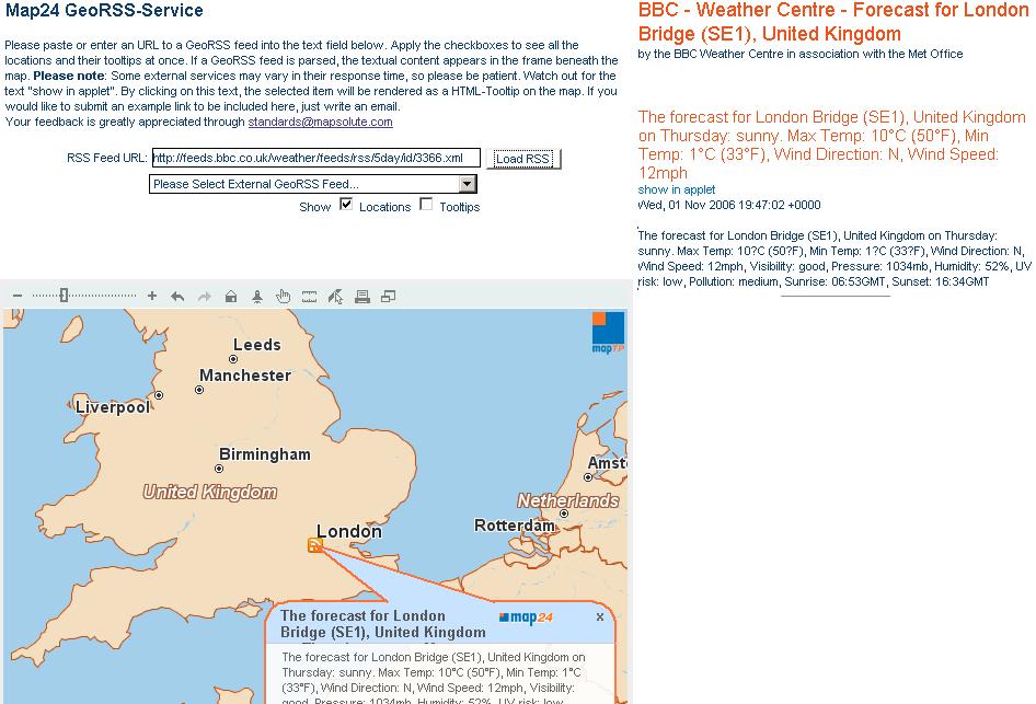
Map 24 now supports GeoRSS feeds

Map24 GeoRSS Feeds

"GeoRSS in general is a technology for distributing news feeds with corresponding location attributes among a great variety of clients. Geographically encoded news feeds may be organized thematically in channels and visualized in web mapping solutions like Map24 Portal. Since GeoRSS is evaluated by the Open Geospatial Consortium (OGC), it is a prospective standard in the geospatial domain."

A large amount of Weather GeoRSS feeds are now available from the BBC Weather Service.
search a region or enter a city (any large city in the world will have a feed)
copy the link (.xml) from clicking the
Weather RSS Feeds View Feed for this Location
http://feeds.bbc.co.uk/weather/feeds/rss/5day/id/3366.xml (London Bridge, UK)
paste into the Maps24 demo.

Labels: , , , ,