->

15 June 2011

Yahoo! Maps APIs Service Closure - Due 13th September 2011

Yahoo! Maps APIs Service Closure - Due 13th September 2011

(And suggest working/moving to Nokia Maps and Nokia Maps API)

"
As part of Yahoo!’s commitment to creating deeply personal digital experiences, we have been reprioritizing our current portfolio of mapping products to refocus on a great consumer Mapping and Local Search experience. After careful consideration, Yahoo! will no longer support the below Maps APIs as of Sept 13, 2011. However, we are continuing to invest in our core maps offering at Yahoo! and later this year will announce more details of our strategic partnership with Nokia, so stay tuned!

We will continue to support a number of location APIs and encourage you to use our Placefinder API for geocoding, our Local Search API and Placemaker for geoparsing.

In the meantime, we have decided to close the following Maps APIs:

Supported Geo APIs and alternative services
Yahoo will continue to support a number of location APIs. We encourage you to use our Placefinder API for geocoding. The Local Search API remains available and Placemaker is still available for geoparsing.

Developers who wish to implement maps, routing and traffic into their web pages may use third-party developer networks for mapping services. We suggest using maps from our partner Nokia. Please go to api.maps.ovi.com/ for more information.


Q&A

Q: On what exact date will the Yahoo! Maps APIs be shut down?
A: Yahoo! will no longer offer the Maps API service as of September 13, 2011.

Q: Why is Yahoo! removing the Maps APIs service?
A: In order to focus on our core strengths and deliver new innovations, we are reprioritizing our portfolio of products and services – increasing investment in some areas while scaling back in others. This will allow us to continue improving the Yahoo! Maps and Local Search experience and allow us to focus on providing best-in-class digital media, content and communications experiences.

Q: What Maps APIs will remain available for developers?
A: Placefinder, Placemaker and Local Search will continue to be supported.

Q: What other resources are available to developers wishing to use maps?
A: Developers who wish to implement maps, routing and traffic into their web pages may use third-party developer networks for services. We suggest using maps from our partner Nokia. Please go to api.maps.ovi.com/ for more information.

Q: What is the status of Nokia integration with Yahoo! maps and navigation services?
A: This work is in-progress and we plan to have something to announce later this year."


More Information

http://developer.yahoo.com/blogs/ydn/posts/2011/06/yahoo-maps-apis-service-closure-announcement-new-maps-offerings-coming-soon/

Labels: , , ,

31 July 2008

Yahoo! Zimbra Maps - New! & Updated Yahoo! Local API

Yahoo! Zimbra Maps - New!

"Yahoo! Zimbra Desktop is the next-generation email application"

Easily set up Zimbra, Yahoo! Mail Plus, AOL and Gmail email accounts with the Account Wizard

Web mash-ups

  • View addresses as Yahoo! Maps
  • Automatically detect your location and find points of interest with Yahoo! Local
  • Preview web pages at thumbnails instead of opening a browser
  • See your calendar schedule from within an email message if you hover over a date
  • Web Search powered by Yahoo! is built directly into Zimbra Desktop
Larger View

Updated Yahoo! Local API
Other Yahoo Local News is that Version 3 of the Local API has been released.
One new feature is the ability to find locations along a route
Here is an example XML output
http://tinyurl.com/6xc8n9
For this map and nearest pizza restaurants
http://cartosoft.com/lab/ygeo/index.htm
"We are releasing a new version of the Yahoo! Local API (V3), that gives developers a key new feature – the ability to search for convenient points of interest for a given user defined route. For example, as you are driving from San Francisco to Sacramento, you could search for a Starbucks or for a hardware store."

The RESTful API now includes a “route” parameter that is a series of latitude/longitude coordinates, with the first pair of coordinates as the starting point and the last pair of coordinates as the ending point. A string sent as the route paramater would be structured as follows:

lat1 long1,lat2 long2,...,latn longn

The API returns XML, JSON, or serialized PHP"

Labels: , , , ,

26 January 2007

LookLocal Maps (now beta 2)

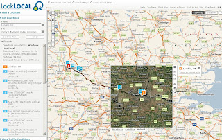
LookLOCAL is an online mapping and location based search site. Access and compare data from Google Maps, Yahoo! Local Maps, and Live Search Maps. View over 6,000 traffic cams, import your own KML layers. LookLOCAL is becoming a personalised online mapping portal.

LookLocal Maps Google with Driving Directions

"We built the site to integrate the search results and data from the three main online map providers. The idea being that it provides the user with the best of all three through a single seamless interface. Thanks for pointing out the zoom box. I've seen those and they are helpful for navigating. The zoom tool on our site is a thin client version of our patented Pliable Display Technology. The idea behind this type of visualization is that you can view additional detail without zooming the bigger picture (your context) off of the screen.

LookLocal Maps Live Local with Driving DirectionsLookLocal Maps Yahoo Map with Driving Directions

The beta 2 version now includes traffic cameras (North America and the UK), listings for some of the world's favourite travel destinations, and the ability to represent multimedia files on a map.

A worthwhile look at the development labs to for:

  • LookOUT is a great new add-in for Microsoft® Outlook® that enables you to easily map a location or find directions straight from your Outlook Contacts window.
  • The new LookLOCAL toolbar extension for Firefox® allows you to map search results or find directions directly from your Firefox browser toolbar.
  • LookWMS is a PDT-enabled Java Web Map Client with several unique features that enable you to access maps from servers that implement the OpenGIS® WMS specification.

Mapperz

Labels: , , , , ,

25 January 2007

Tag Maps - Explorer Maps

Tag Maps - World Explorer, Night Explorer & Trip Explorer

"TagMaps are a new way to visualize text on geographic maps. TagMaps can be used to communicate key characteristics of location-based data in an easy-to-understand way."
  • Visualise text (tags) geographically on a Yahoo! Maps.
  • Where Flickr tags are added to map for easy locating
World Explorer, Night Explorer & Trip Explorer Maps

There are three types of map available:
More Information at the FAQ
Yahoo! Map Developer API

Source: ProgrammableWeb

Mapperz

Labels: , , , ,

17 January 2007

Phoogle Maps (v2.01)

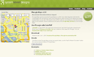
Phoogle Maps (v2.01) includes International Address Support.
  • 1 Address (Outside United States)
  • Multiple Addresses
  • Displaying Valid/Invalid Points
  • Customizing the Info Window
Phoogle Maps PHP with Google Maps and Yahoo Geocoder
"Phoogle Maps (pronounced like Foogle Maps) is a PHP class that integrates itself with the Google Maps API and with the Yahoo Geocoding API to make an easy to use interface to display Google Maps on your site."


Mapperz Note to Users: Check the Yahoo Maps API Terms and Conditions before investing time on this. There maybe infringement using the Yahoo Geocoder with Google Maps.

Labels: , , , ,