->

25 April 2007

Google Spreadsheets - Geocoding

Google Spreadsheets - Geocoding (well almost...)

Mapperz looking for London (UK), but gets the wrong London!

*Please note this is not a full solution and it might seem to geocode, but check all locations.

Not really documented on the geocoding side but the is =GoogleLookup function that seems to understand "latitude" and "longitude" in a request formula in Google Spreadsheets

Here is an example (google account holders can edit and see the function)
http://spreadsheets.google.com/pub?key=pAxR-aN5DCiWkZ60GpHxJOQ

Google Spreadsheets Geocoding Nearly
Note 'London' is not London,UK but London (Kentucky)

Same goes with Paris, no it's not Paris, France but Paris, Kentucky

detecting a pattern here?

But potentially a useful service, though some standards are needed to be able to get the correct users location, maybe "Location, State/County, Country"

For more information on this have a look at Ogle Earth post on it.

Sticking to having lat and lng fields in the spreadsheet and using google maps with
javascript:void(prompt(%22http://www.google.co.uk/search?
q=%22,gApplication.getMap().getCenter()));
(copy and paste that code, if doing lots create a bookmark, FireFox works best)

More details on that script on a previous post.

Labels: , , , ,

04 January 2007

Crown Copyright crushing UK Mapping Innovations

This is a post to make people aware that government agencies are stifling UK innovations.


"Public money paid for it - but the public can’t view because of crown copyright"

Says the Guardians Free Our Data Campaign

"Imagine flying at rooftop height up the Thames. You dive under Tower Bridge, then twist between the Gherkin and Tower 42 skyscrapers. As the London Eye looms, you bank right and dive into a translucent globe which transports you into the middle of St Paul's cathedral."


But you can't put it online!

"Although Virtual London was funded by another state body, the computer model cannot be posted on the web without infringing Ordnance Survey's copyright."

"Public money funds it, yet "public" copyright keeps it shut away."

But how can Geographically data be locked down to some ceramic hard drive and not accessible to the people who paid for it?

Nicely timed just ahead of Christmas, the Department for Constitutional Affairs has put its Statute Law Database online. You can search for any extant law, and various others - including how upcoming legislation will affect existing laws.
This was protected under crown copyright so why can this be released to the public free of charge and available online?

Come on Ordnance Survey sort your out of date crown copyright.
Reduce your prices to commercial vender's and you will gain more consumers and increase your incomes 10 fold.

Sources:
http://freeourdata.org.uk/blog/
http://technology.guardian.co.uk/weekly/story/0,,1981821,00.html
http://www.ordnancesurvey.co.uk/oswebsite/aboutus/
yourinforights/copyright/index.html

Even little company Google are having issues with Ordnance Survey -

"The sticking point is understood to be Google's attempt to negotiate a fixed fee for the data, rather than accepting Ordnance Survey's practice of charging by the number of transactions. Ordnance Survey would not comment on the specific case, but said that a fixed fee would "wreck the level playing field for other partners" - and it should be noted that it is obliged to treat all customers (including itself) on the same terms. OS said it is happy for its data to be used in a "Google-type" environment. "Sites such as Multimap and Streetmap use our data and their services are freely available to the public over the web.""

Labels: , , , , ,

14 December 2006

ArcGIS 9.2 Service Pack 1

ArcGIS 9.2 Service Pack 1 will be released next week (18th December 2006)

No 'Issues Addressed' reported on the website yet.

But since most UK ArcGIS users have yet to receive ArcGIS 9.2

Top Tip: Do not install until SP1 is Downloaded and on CD.

So after months of alpha, betas and release candidates... you still need to patch up the holes.

If ESRI want to win more users, a public beta (one without having to spend 20% of your time reporting back to ESRI for Free).

Embarrassed? (you would be)

UPDATE:
ESRI (UK) confirmed today that ArcGIS Desktop 9.2 will not be available until February 2007.

Even though EDN 9.2 is Delivered to UK EDN Users.

Therefore ArcGIS Engine, Runtime etc cannot be used with Desktop

Nice One ESRI!

So that MapInfo....

Labels: , , ,

13 November 2006

Google Maps Africa but....

Good to see that Google are expanding data coverage across the world. But be very wary on the accuracy of the data.
Info:Geek Tip - Map Tiles Version 31 not available in the API as yet.

Overall the Major Cities are coverage and general very good.

Though this a prime example of which worries mapperz.

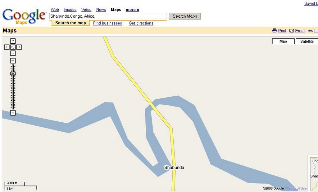
Shabunda Congo Africa Map - Map View
Shabunda,Democratic Republic of the Congo, Africa
Map (looks fair good road crossing the river...)

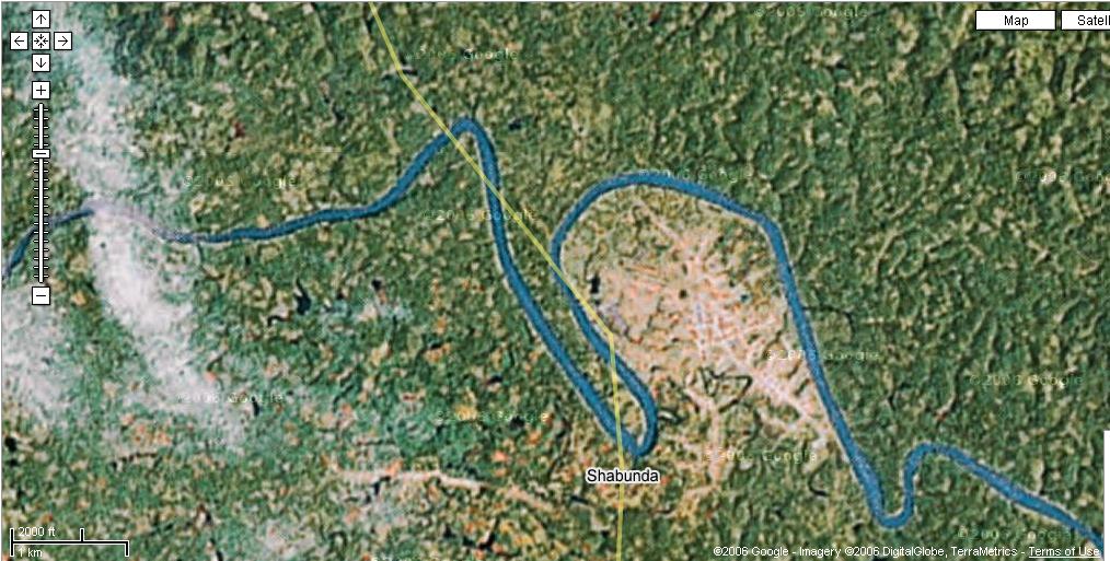
Now switch to hybrid.
Shabunda Congo Africa Map - Hybrid View

Now your need a lot of Bridges! (5 in fact!)

So just be careful.

Another example where cartographic generalization can be a bit too extreme!

Labels: , , , , ,