->

25 February 2009

Google Map Maker Directions - New!

Google Map Maker Directions - New!

Last week, Google switched on the MapMaker Tiles for API developers. See previous post (12th Feb '09).

MapMaker is based on user generated content.

"With Google Map Maker, you can become a citizen cartographer and help improve the quality of maps and local information in your region. You are invited to map the world with us!"

Now those tiles have graduated to Google Maps. 31 countries (of 160+) have made it so far - though this is likely to expand through the year and beyond.

The Full List is available
http://sites.google.com/site/mapmakeruserhelp/countries-on-google-maps

But wait there is more...

Driving Directions in MapMaker New!
(but use with caution)
Google Map Maker Directions - New
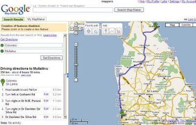
Directions in a simpler form have been enabled, usually only the likes of TeleAtlas navigation is used on Google maps but now user contributed content is being used for the first time available in Map Maker Mode only at present [google login required].

Some of the countries do not have the simplified driving directions available.

Here is a working example
http://www.google.com/mapmaker?hl=en&ctype=0&saddr=Quetta&daddr=Zhob&dirflg=&gw=56&ll=30.192618,68.895264&spn=4.756322,7.426758&z=7
but don't expect this to be the shortest route.

Here is a better example
http://www.google.com/mapmaker?hl=en&ctype=0&saddr=Colombo&daddr=Mullaitvu&dirflg=&gw=56&ll=8.070086,80.330403&spn=2.724552,3.713379&z=8

Source:
http://sites.google.com/site/mapmakeruserhelp/using-directions

Labels: , , , , ,

12 February 2009

Google Map Maker Tiles come to the API

Google Map Maker Tiles come to the API

Update:
One of the best areas of difference is in Sri Lanka
Here is the differences in Colombo


Google Maps Normal Tiles limited in content.
This shows the power of user contributed content.

http://mapperz.googlepages.com/mapmaker_api_sri_lanka.html
(Warning this example is in the latest *experimental* version of the api v146b and GLog is always displayed)

Google Map Maker gives users the power to add, edit and amend data in Google Maps.
This has been running for awhile, but as yet it has not been used by Google in the Main Google Maps Site.

A first. The Google Maps API has had the option of (G_MAPMAKER_NORMAL_MAP);
for a while but this has not been enabled, until today.Normal Google Map Tiles
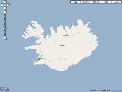
Here is one Country in Google Maps with very little data coverage. Iceland.

But now with the API you can switch on the User Made Tiles from Google Map Maker.

Google Map Maker Tiles - Available
Not much more detail , but it is better than the normal tiles from Google Maps.
Note:Copyright is Google only. (Coastline TeleAtlas still?)

There are a number of Countries and this is one example, so check the list and see if the country your are interested has more content than the original Google Map Tiles.

You can view the example here:
http://mapperz.googlepages.com/mapmaker_api_iceland.html


Mapperz would like to thank Mike Williams for the tip off .
http://groups.google.com/group/Google-Maps-API/browse_thread/thread/4d44eed7fca98d35?hl=en#


Full list of Countries in Google Map Maker
* Algeria
* American Samoa
* Angola
* Anguilla
* Antigua and Barbuda
* Argentina
* Armenia
* Aruba
* Azerbaijan
* Bahamas
* Bahrain
* Bangladesh
* Barbados
* Belize
* Benin
* Bermuda
* Bhutan
* Bolivia
* Botswana
* British Indian Ocean Territory
* British Virgin Islands
* Burkina Faso
* Burundi
* Côte d'Ivoire (Ivory Coast)
* Cambodia
* Cameroon
* Cape Verde
* Cayman Islands
* Central African Republic
* Chad
* Chile
* Christmas Island
* Cocos Islands
* Colombia
* Comoros
* Congo
* Cook Islands
* Costa Rica
* Cuba
* Cyprus
* Democratic Republic of Congo
* Djibouti
* Dominica
* Dominican Republic
* Ecuador
* El Salvador
* Equatorial Guinea
* Eritrea
* Ethiopia
* Falkland Islands
* Faroe Islands
* Fiji
* French Guiana
* French Polynesia
* French Southern and Antarctic Lands
* Gabon
* Gambia
* Ghana
* Greenland
* Grenada
* Guadeloupe
* Guam
* Guatemala
* Guinea
* Guinea-Bissau
* Guyana
* Haiti
* Heard Island and McDonald Islands
* Honduras
* Iceland
* India
* Iran
* Jamaica
* Jordan
* Kazakhstan
* Kenya
* Kiribati
* Kuwait
* Kyrgyztan
* Laos
* Lebanon
* Lesotho
* Liberia
* Libya
* Madagascar
* Malawi
* Maldives
* Mali
* Malta
* Marshall Islands
* Martinique
* Mauritania
* Mauritius
* Mayotte
* Micronesia
* Midway Islands
* Mongolia
* Montserrat
* Morocco
* Mozambique
* Myanmar
* Namibia
* Nauru
* Nepal
* Netherlands Antilles
* New Caledonia
* Nicaragua
* Niger
* Nigeria
* Niue
* Norfolk Island
* Northern Mariana Islands
* Oman
* Pakistan
* Palau
* Panama
* Papua New Guinea
* Paraguay
* Peru
* Philippines
* Pitcairn Islands
* Qatar
* Reunion
* Rwanda
* Saint Helena
* Saint Kitts and Nevis
* Saint Lucia
* Saint Vincent and the Grenadines
* Samoa
* São Tomé and Príncipe
* Senegal
* Seychelles
* Sierra Leone
* Solomon Islands
* Somalia
* South Georgia and the South Sandwich Islands
* Sri Lanka
* Sudan
* Suriname
* Svalbard and Jan Mayen
* Swaziland
* Syria
* Tajikistan
* Tanzania
* Timor-Leste
* Togo
* Tokelau
* Tonga
* Trinidad and Tobago
* Tunisia
* Turkmenistan
* Turks and Caicos Islands
* Tuvalu
* Uganda
* Uruguay
* Uzbekistan
* Vanuatu
* Venezuela
* Vietnam
* Wallis and Futuna
* Western Sahara
* Yemen
* Zambia
* Zimbabwe


You can view the example here:
http://mapperz.googlepages.com/mapmaker_api_iceland.html

Labels: , , , ,

09 September 2008

Where is the GPX Path?

Where is the GPX Path?

(well the answer is on the map now thanks to Bill Chadwick's update of GPX import.)

South West Coastal Path - Lizard Point (Cornwall)
Importing of GPX data is very fast and when in 3D (Earth) Mode it shows you the terrain your likely to encounter. (weather not included!)

"GPX to GeoJson Converter is purely a convenience for those who want to read a random GPX url on a page from a host that lacks server side scripting"

Example - The South Coastal Path
http://tinyurl.com/5zd4af

NOTE* The most annoying issue for this site is not the author's fault at all. It's the Ordnance Survey with ridiculously low openspace tile quota (currently 30,000 per 24hrs).
This is a very popular site and 30,000 tile impressions needs to be 75,000 at least.
Why does the Ordnance Survey insist of bottlenecking useful web mapping applications?
And why allow users to have 1:50,00 colour rasters (Landranger Maps) and StreetView 1:10,000 and not the very useful 1:25,000 (Explorer Maps)?

Data for the South West Coastal Path is available from (GPX format for GPS)
http://www.southwestcoastpath.com/main/useful_info/GPS-downloads.cfm

For more information on the technical aspects please visit
http://groups.google.com/group/Google-Maps-API/browse_thread/thread/69f83113b27388a3

Labels: , , , , ,

06 March 2008

Master Class: Creating Custom Maps

Creating Custom Maps with John Coryat

How do you do 'Custom Tiles' in Google Maps?

An excellent presentation explains it all.

Software/scripts required
Perl 5.8 with DBI, GD and CGI modules
USNaviguide_Google_Relpix Perl module
USNaviguide_Google_Tiles Perl module
PostgreSQL 8.2 with PostGIS Extension (Mapperz recommends PostgreSQL)
Apache 2.0 webserver
ProjectedImage.js (Javascript)
US Census Cartographic Boundary County Shapefiles
Geonames.org US.zip data file

Or the PDF version

http://www.usnaviguide.com/ws-2008-02/presentation.pdf(5.5mb file)

Examples and Presentation Materials
http://www.usnaviguide.com/ws-2008-02/download.zip (111mb file)

Well done http://maps.huge.info/blog

Labels: , , , , ,

14 December 2007

Google Maps API - See the Sky, Moon and Mars

Google Maps API - have released Sky, Moon and Mars tiles in Version 2.95 of the API.

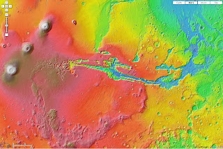
Google Maps API Mars Elevation Mode
Mars Elevation Tiles

This means you can now call up the tiles that Google Maps Moon/Mars and Google Earth Sky mode use.

Google Maps API Mars Mode
Mars there is an Infrared option too.

Google Maps API Sky Mode
It's dark out there!

Google Maps API Moon Mode
no cheese but good detail.

The original page
http://econym.googlepages.com/example_moon.htm

one bug found by Mike Williams [Google Maps API Guru]
http://econym.googlepages.com/bug_moon.htm
polylines disappears on switching modes
[this bug is already reported]

Mapperz version soon followed - as the curiosity got to them.

http://mapperz.googlepages.com/Google_SKY_MOON_MARS_Official_API.htm
l

More info:
http://groups.google.com/group/Google-Maps-API/browse_thread/thread/9da5d9f4d8dae310#

Official Blog Post
http://googlemapsapi.blogspot.com/2007/12/maps-from-another-world.html
Official Examples
http://gmaps-samples.googlecode.com/svn/trunk/planetary/planetary_maptypes.html

Labels: , , , , ,