Open Route Service using Open Street Map Data
OpenRouteService.org is taking OpenStreetMap Data and making use of the Street Data and creating Full Descriptive Routes from it.
*Currently only for Germany

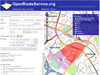
Blue Line represents the calculated 'fastest' route. Summary and full 'turn by turn' directions

Currently in German but gives you full turn by turn directions.
"Routing services are probably the most important application for street data - apart from visualizing them on a map. While there are a range of desktop (or even mobile) applications that can provide such functionality also in combination with Open Street Map data, we focus here on an approach based on the concept of interoperable Service Oriented Architectures (SOA). These are regarded as an important concept for forthcoming software architectures in general, and more and more being applied also in the GI (geographic information) sector."
Polygon Avoidance Areas

The same route as above though this time a digitized polygon (red area) defines an area for avoidance, the route is processed in less than 3 seconds.
Try it here
http://data.giub.uni-bonn.de/openrouteservice/index.php
Data Sources
OpenStreetMap
Internal use of Germany Five-Digit Zip Code from ESRI Data & Maps 2003 for Geocoding
Created by http://www.geographie.uni-bonn.de/karto/
Labels: Avoidance, Data, Map, Open Street Map, OpenRouteService, Routing


0 Comments:
Post a Comment
<< Home