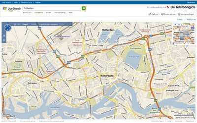
Live Maps Netherlands
Live Maps Netherlands

Live Maps partners with De Telefoongids to localize the Netherlands for improved searches.
Straat (Steet Map)
The Netherlands is excellent in Virtual Earth (better than Google) more named roads throughout the country.
Lucht (Aerial)
Tulip fields in 'Holland'
There is low resolution satellite imagery and high resolution aerial photography in the towns and cities.
Vogelvlucht-weergave (Bird’s Eye View) – 43 Dutch cities in Bird’s Eye.
3D (but is very flat!)
Live Maps Netherlands now has the 3D view activated. This allows viewing the world in all dimensions, near-real-time weather and a growing number of 3D cities. Bird’s Eye overlay allows overlying the 3D view real bird’s eye photography.
Bedrijven (Yellow Pages)
Put in the Wat (what) and put in the Warr (where) and start local searching provided by De Telefoongids.
Verzamelingen (Explore Collections)
It is now possible to explore collections on Live Maps Netherlands. Collections are user generated content that is collected from all over the web.
Delen (Share)
Users can now not only share map links in mail but also publish to blogs or websites with a click.
Route-advies (Directions)
The routing engine now allows the creation directions using Snelst (quickest route), kortst(shortest route) or lopen (walking) algorithms. Walking directions is available in the Virtual Earth giving users the quickest way suitable for pedestrians.
See Live Maps Netherlands:
Source:
http://blogs.msdn.com/virtualearth/archive/2009/01/15/live-search-maps-netherlands-geboren.aspx
Labels: 2009, De Telefoongids, Live Maps, Local Search, Netherlands


0 Comments:
Post a Comment
<< Home