192.com Mapping Updated
192.com Mapping and API Updated
- 12.5cm resolution aerial photography UK-wide
- Ordnance Survey maps with 100% of streets labelled
- Maps based on Flash technology
192.com has just launched a number of new enhancements to its interactive mapping tool including the highest resolution aerial photography, exclusive UK styled maps and a new journey planner

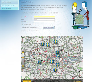
Kwik Fit uses 192.com Mapping for their website and works well.
These features make 192.com Maps a dynamic user experience designed specifically for the UK market.
"192.com is today announcing the first in a series of major improvements to its maps service, first launched last autumn and experiencing a surge in traffic in recent months. 192.com has republished all of its street maps after exclusively redrawing every UK map to incorporate the latest Ordnance Survey data and ensure street labelling was in an easy to read format. 192.com is unique on the internet for labelling 100% of UK streets (typically rival sites name 70-80%) and so uses hand drawn labelling particularly for crowded, historic cities with many street names in close proximity. The colouring of the maps has also been optimised to suit motorists and non-motorists alike and to accommodate the changing requirements of computer and mobile screens. The aerial photography, already acclaimed as the best available for the UK, has improved further and offers unrivaled clarity and resolution nationwide, not just in cities. But it’s the transition between maps and photography that really sets 192.com’s new maps apart, with the smoothest, cleanest transfer from map to map, and map to detailed aerial photography."
Having looked into these at more detail there seems to be a lot going on under the hood.
If your an experience programmer you will able to create flash based maps in a few minutes
Though a quick start tutorial with live example would aid the non-experienced programmer.
Clearly the mapping is excellent and well put togeather and seems to be the only online mapping fully based on Ordnance Survey Mapping. This must of cost a small fortune to buy or licence.
Here is a list of the scales available
- 0 = 0.125 metres/pixel Aerial Photo
- 1 = 0.25 metres/pixel Aerial Photo
- 2 = 0.5 metres/pixel Aerial Photo
- 3 = 0.125 metres/pixel Aerial Photo
- 4 = Street level OS map
- 5 = OS map
- 6 = OS map
- 7 = OS map
- 8 = OS map
- 9 = OS map (most zoomed out – whole of UK)
as the OSCAR Dataset is now withdrawn
Labels: 192.com, Aerial Photography, Directions, Flash, Mapping, updated


3 Comments:
It may be higher resolution than GE, but it is a lot more grainy. I prefer Google's aerial photography.
Well, Kwik Fit now seem to be using Google Maps rather than 192.
There again, the whole of 192 mapping seems to be down for the last month (they deny anything is wrong though, so it may be three computers of differing OS on two different networks may be completely wrong of course!).
Great idea while it lasted...
Kiwik fit kicked out 192 as they could not fulfil their needs. 192 are not very good at all and Kwik fit are using Google for a short while before moving over to ViaMichelin.
I have looked at all of the mapping providers and ViaMichelin for me have the best offering and at a good price. 192 on the other hand are still new though their mapping is quickly being outdated.
Post a Comment
<< Home