->

08 January 2010

Ovi Maps Racing - Sneak Peak

What happens when you combine Ovi Maps and Ovi Games? Ovi Maps Racing is what happens – another gaming title announced today by Nokia, coming soon to the Ovi Store.

Ovi Maps Racing


"In a truly unique experience, you use the GPS in your device to find your location or use Ovi Maps to choose any location in the world), then customize a track around your neighborhood, and finally fire up those engines."


useful? or just fun... you decide.

Labels: , , , , , ,

06 February 2009

CloudMade - A Preview the Future of Mapping

CloudMade - A Preview the Future of Mapping

update:


Have faster maps - if you use Open Street Map - Please donate to help get whizzy fast servers.
http://donate.openstreetmap.org/
  • Funding Target: £ 10,000
  • Raised: £15,579 (155.79%) - Well Done!
  • Google donates £5,000 (source: twitter)
(invest your money here rather than a UK bank - your get a better return)

And there are thanks from the Open Street Map Team
"UPDATE: Thank you to everyone who has donated. Any additional contributions raised will be used to fund additional hardware on other under resourced OpenStreetMap servers."

Cloudmade Map - Cycling Directions Export
Sneek Peek - Cycling directions with option to export to JSON or GPX format

"On the evening of the 12th February, CloudMade invite you to preview the future of mapping application development. Our developer launch event will feature a keynote talk from CloudMade Founder Steve Coast, who will share his pioneering vision of mapping."

The evening will also feature presentations from a selection of CloudMade partners who will demonstrate never seen before web and mobile applications built using CloudMade's web services. You'll have the opportunity to talk one on one to the CloudMade team and to our partner developers to find out exactly how CloudMade can help you build better applications.

The London launch event will be held at the Holborn Bars, 138-142 Holborn, The City, London, EC1N 2NQ (view on map). There will be a drinks reception and networking from 6 - 6.30pm followed by presentations and the launch event. The event will conclude around 8.30pm, with some time for additional networking.


"CloudMade's web services are going to change the way your users experience geo apps. We've been working on a set of Tools and APIs to give you access to verified OpenStreetMap data on the platform you choose in the formats you want."

Two developer events in San Francisco and London will introduce you to CloudMade's unique services. If you're a developer building web, mobile or desktop mapping applications, these are the events for you.

Sneek peek video showing the neat map editor 'Edit Map Styles'


CloudMade StyleEditor ScreenCast from CloudMade on Vimeo.

Labels: , , , , , ,

24 September 2008

Virtual Earth 6.2 Maps [Sneak Peek]
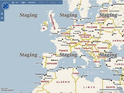
Virtual Earth 6.2 Maps [Sneak Peek]
Virtual Earth 6.2 Maps in French
French Language Map Tiles soon to be available

Virtual Earth 6.2 Maps in German
German Language Map Tiles soon as well

Virtual Earth 6.2 Maps in Italian
Italian Maps


You can see what is new in Virtual Earth 6.2 [but not fully updated yet]
http://dev.live.com/virtualearth/sdk/

* Static maps
* Direct map tile access
* Aerial map imagery metadata
* Pushpin clustering
* Landmark-based directions
* Improved geocoding
* Expanded rooftop geocoding in the US

# Pushpin clustering. Use the VEShapeLayer.SetClusteringConfiguration Method to set how to display and cluster overlapping pushpins for better shape display at higher altitudes.

# Hints for route instructions. Help your users find route turns with hints about nearby landmarks and intersections using the VERouteItineraryItem.Hints Property.

# Imagery metadata. Retrieve information about imagery using the VEMap.GetImageryMetadata Method.

# Base map disabling. Use the Virtual Earth Mercator projection in non-mapping applications by turning off the base map with the VEMapOptions.LoadBaseTiles Property. You can use the VEMap.HideScalebar Method as well.

# Support for other languages. Retrieve maps with labels in French, German, Italian, and Spanish from Virtual Earth. See the Returning Localized Results topic for a list of supported culture strings.

# 3D model import. Import 3D model data files into a shape layer using the VEMap.Import3DModel Method. Interact with these models as you would any shape.

# Updated interactive SDK. See the new functionality of the Virtual Earth map control demonstrated in the updated Virtual Earth Interactive SDK.
[not yet available]


Mapperz Source:
http://www.nateirwin.net/post/Virtual-Earth-62-Coming-September-22nd.aspx
[but it's the 24th September]


Labels: , , , , , , ,
